View allAll Photos Tagged Maps
Taller de Proyecto/ ELISAVA
Maquetas preliminares/ diseño de la información del borde cotero, para proyecto de imágenes construidas a partir de un sistema visual, según el modo en que son a.bordados.
Virginia Institute of Marine's Marine Advisory Program's 'Teachers on the Estuary: A Field Course on Virginia's Coastal Ecosystems' workshop held along the Eastern Shore. Jun 25, 2019. (Photo by Aileen Devlin | Virginia Sea Grant)
I was approached online by them with a request to use a specific photo, and they did a pretty good job of it, too. No pay, but then i wasn't concerned about that, just my name and some copies - which arrived today! Thanks Where Maps!
The originally flickr-posted photo is here.
Map of The Imperial City Hoàng thành within the citadel Kinh thành of the city of Huế.
Thừa Thiên–Huế province, Vietnam 2018.
We landed at Saranda and took about a 45 minute drive to Butrint
More info - www.butrint.org/index.php
Map detailing the location of events of the wedding day for a PA/NJ wedding
I painted the original and gave it as a shower gift.
Séminaire artistique / Workshops / Performances
En savoir plus : lecube.com/fr/map-multicasting-art-platform_2730
© Le Cube
A map of the Market Street Railway Company's City Wide Service. This projection seems to be fairly common in early to mid century maps of San Francisco- for example, there's this map of proposed freeways.
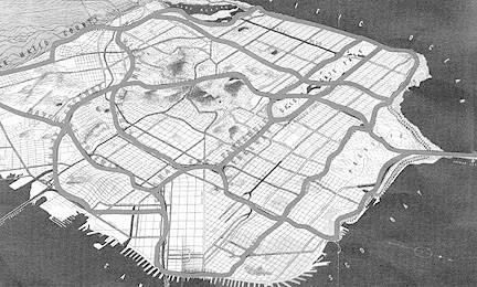
Taken at the San Francisco Railway Museum.
A 1-mile square view of baltimore reveals the highly rigid grid system, along with the cut through of alleyways that define the feel of neighborhoods like Fells Point, Canton, and Patterson Park
Software: Adobe Illustrator
2007 4”x6”
Antique french map, gel medium on paper.
This piece is one of a series of map collages. I found an antique book of maps in the gutter while in paris, and got inspired to create these intimate collages. This series studies the differences and similarities between the French and Americans, both who I feel a strong connection with. We each try to separate ourselves from the other, especially after the start of the war, but are we really that different? This work creates a landscape of sorts, from what were paris city streets. It creates a new map, showing that when you rearrange something or look at it from a different angle, one place could look like another.
For a school project, my son made two 3D standard heroclix size maps which can be combined into one large map. This is the combined map. Hot wheels cars can be added to the roadway to provide detail as well as objects for the game.