View allAll Photos Tagged Maps
On another sunny spring day I took a cross-country walk from home to Lane End skirting the north side of town via Four Ashes, Hughenden Manor, Downley, West Wycombe and Toweridge catching the old boys bus back home, total distance about 15.0km
It's on Strava so it must be true!
.
Walkabout 2025 album ... flic.kr/s/aHBqjBXsk2
2560sqm, 878 land capacity, Laka. Protected navigable lot for rent in volcanic islands & Linden Waterfalls. Beautiful home furnished and landscaped. Waterfall, and enough water for medium sized boat. Lot is for sale or rent.
Description: Map of Massachusetts with political boundaries and topographic relief.
Note: Map with tactile elements for use by the blind.
Creator: Perkins School for the Blind
Date: 1908
Format: map
Digital Identifier: MAPS-00032
Rights: Samuel P. Hayes Research Library, Perkins School for the Blind, Watertown, MA
店(住宅)を回って広告料を取って地図看板を作って掲出するという怪しい商売があるようですけど。これは後に手書きで書き加えたり新聞広告を貼ったりしているようですが地図屋さんがやったのか?店が勝手にやったのか?
View in Google Earth: large or original size
Planning map for BART lines and stations.
In this version, the outer reaches of the system are postponed to the future for cost reduction and the Mission/I-280 route is considered.
This was my big summer project this year! A full map of the continental United States all in patchwork and embroidered! You can see more pictures at:
Left & Centre: Modern Pictorial World Atlas c1939
Right: Encyclopaedia Brittanica 10th Edition Maps c1897
www.tagzania.com/paste/item/20170
www.panoramio.com/map/#lt=27.373139&ln=88.844376&...
www.pazu.com/travel/asia/map.html
The maps here are neither accurate nor precise, it doesn't reflect the real path that I travelled
Originally composed in 932 AH / 1525 CE and dedicated to Sultan Süleyman I ("The Magnificent"), this great work by Piri Reis (d. 962 AH / 1555 CE) on navigation was later revised and expanded. The present manuscript, made mostly in the late 11th AH / 17th CE century, is based on the later expanded version with some 240 exquisitely executed maps and portolan charts. They include a world map (fol.41a) with the outline of the Americas, as well as coastlines (bays, capes, peninsulas), islands, mountains and cities of the Mediterranean basin and the Black Sea. The work starts with the description of the coastline of Anatolia and the islands of the Aegean Sea, the Peloponnese peninsula and eastern and western coasts of the Adriatic Sea. It then proceeds to describe the western shores of Italy, southern France, Spain, North Africa, Palestine, Israel, Lebanon, Syria, western Anatolia, various islands north of Crete, Sea of Marmara, Bosporus and the Black Sea. It ends with a map of the shores of the the Caspian Sea (fol.374a).
See this manuscript page by page at the Walters Art Museum website:
Points worthy of note:
The Frome and Back ditch are fully open watercourses. On the 1829 Ashmead, warehouses behind Merchant Street begin to be built over it. (The castle moat was not accessable to Donne's surveying but was also wholly open to the air, except castle st and queen st bridges)
Bridewell Mill was still grinding Corn twice a day on each low tide at its 9 foot high weir
key index marker no. 39, bottom left relates to Union Street and St James Meat Market, then proposed.
Park Street is laid out, but thats about all!
St Giles or Stone bridge still has the Frome flowing under its twin 1755 spans at head of quay. The right hand arch was not filled in until 1826 when Mylne's culvert tide gates and sunken access compound were built.
Bath Street has not been built at Hf diagonally from Bridge Parade to Temple Street
The twisting narrow Halliers lane has to wait 27 years to become Nelson Street (Needless bridge, 2 gothic spans of 1696 is still only 14 feet wide)
Treen Mills malago pond has 31+ years to wait to become Bathurst Basin
The 120 foot Prewett Street glass cone, of which its base is now the Ramada restuarant was not be to built for another 7 years
This trip took months of planning, using reference material form local council plans, contact with urban planners and hours on the internet. In the end we came up with the ultimate Dublin Tour. Pub one being only 7.32 metres from the door of the hotel was an ideal meeting place both before excursions into the city & afterwards. Most routes lead to 'Oliver St John Gogarty's' in Temple bar (Both Nato & the EU rate this as 'probably the finest bar in europe). A couple of pints in 'The Bank' in Dame street (only so we could go to the ATM and a couple in a random pub near some shops. The planning paid off....
The freedom to roam in nature has diminished for children over years, but I was fortunate to grow up in Auchtertool, a rural village in Fife, so I mapped the extent of my childhood wandering and important sites for me.
Natural Thinking Report: ww2.rspb.org.uk/Images/naturalthinking_tcm9-161856.pdf
Basemap: services.arcgisonline.com/arcgis/rest/services/World_Imag...
Symbols: github.com/OrdnanceSurvey/GeoDataViz-Toolkit/tree/master/... and thenounproject.com/
Created using QGIS 2.18, symbols adjusted using Inkscape 0.91.
Ooooh-La-La! Hop over to the Potted SL Mainstore and snatch up this gorgeous goodie!
- Brewed Bliss Post - LE Tree Cutter Philodendron Pot
Available through 12/31 and Limited to 1 per Avi per 24 Hours
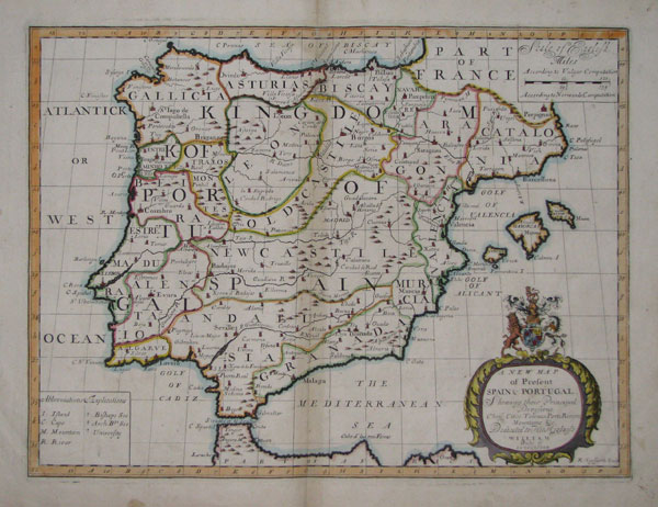
A New Map of Present Spain & Portugal, Shewing their Principal Divisions Chief Cities, Townes, Ports, Rivers, Mountains &c. Dedicated to His Highness William Duke of Gloucester.
R: Spofforth Sculp.
[Oxford, Edward Wells, c.1700.]
Coloured engraving. 380 x 495mm, 15 x 19½".
Map of the Iberian peninsula, engraved by Robert Spofforth and published for " A new sett of maps both of antient and present geography".
[Ref: 15349] £220.00
Divisions of Kingdom of Spain:
- Gallicia.
- Asturias.
- León.
- Old Castile.
- New Castile.
- Andalusia.
- Granada.
- Murcia.
- Bizcay.
- Navarre.
- Aragon.
- Catalonia.
- Valencia.