View allAll Photos Tagged Limestone
www.facebook.com/matrobinsonphoto
Firstly, apologies if this is over the top/too colourful! I have in fact toned the saturation down... along with otherwise normal processing for me. My computer is dying under running actual work code, so this is the only shot I've managed to look at so far.
Last night I finally went camping up Ingleborough, I found a lovely flat spot just below the summit (over to the left of this photo) and yet still managed to only get a single hour's sleep (or less, I wasn't counting... but it definitely wasn't more!), despite it being my most comfortable camp yet. This one's from last night's sunset looking along the sweeping curve of the hill, it's no wonder it's my favourite hill/mountain in the country - and always has been since I first laid eyes on it as wee lad being driven over from Wensleydale. Considering this photo was followed by a snapped tent pole, the night went pretty spiffingly other than the lack of sleep (I was only ever aiming for 3hrs, so 1 isn't so bad...).
So I was up at 3.15 to pack away the tent and have a quick breakfast and coffee in the early morning glow (with the best view I could imagine) before heading for the summit for sunrise - photos of which I'm sure will follow tomorrow. There was a beautiful inversion to the south, beyond Settle. A small part of me was jealous of this as it looked perfect for the Warrendale Knotts shot I tried so hard for over winter, with mist pouring over the limestone outcrops... but I was in no position to complain - not many people have seen the Lake District mountains, Howgill Fells, Yorkshire Dales and even Peak District before 5am! The air was beautifully clear, it was almost surprising I couldn't spot Snowdonia.
All that and I was back in York for 9.15 to get on with a normal day...
Sorry for the rambling, blame that on the lack of sleep too...
Un-branded DB Cargo 60010 heading the 16:10 Tunstead Sidings to to Lostock Works, Northwich loaded limestone at Peak Dale on Tuesday 21st May 2019.
© Gordon Edgar - All rights reserved. Please do not use my images without my explicit permission
The Blair Limestone Kilns at Canoe Creek State Park was part of an early 1900s limestone processing facility, a subsidiary of Jones and Laughlin Steel, that served Pennsylvania's iron and steel industries. The kiln, once eight stories high, was demolished during WWI, leaving behind the cooling towers. The site is now a historical point of interest on the park's Limestone Loop trail and a feature on the state's Path of Progress tour.
The kilns produced quicklime, a vital material for removing impurities during iron and steel manufacturing.
The kilns were built in 1907 and were demolished by 1917, with operations ceasing around 1910 due to high transportation costs, according to some sources.
Canoe Creek State Park, Blair County, Pennsylvania, US, October 1, 2025, DSC00661
1/124
I swung by Proctor before work yesterday morning to try and get a shot of the maroon pair. Just as I pulled up this limestone train was approaching the overpass. I managed to catch him as the morning sun illuminated the power and the first couple of cars through a gap in the trees.
Image from the same night a week ago when we spent the entire night under the stars in this incredible desert landscape. Watching the sky light up with countless stars and distant galaxies is always mesmerizing. There's something truly special about being surrounded by ancient rock formations and the quiet of the night.
Those two faint smudges are the Small and the Large Magellanic Clouds, dwarf galaxies orbiting the Milky Way. They're both visible to the naked eye under dark skies in the southern hemisphere all year round.
Sky
Nikon D700
Samyang 24mm f/1.4
60s, f/2.8
Foreground
Nikon D5200
Samyang 24mm f/1.4
Not been out with the camera much since the Wales holiday - DIY, gardening, and a stinking cold all took their toll. Got well up the Dales today but it was blowing a gale. Walked about a bit with the 5x4 but put it back in the car and got the digital out
A DMIR tunnel motor leads an empty limestone train down the hill for a reload. You can tell winter is approaching and it could snow anytime by the side dumps being placed in this service.
We all take inspiration from each other and my thanks go to www.flickr.com/photos/13922644@N05/ whose recent upload showing this scene prompted my visit, Cheers Terry .
Shot taken on the Yorkshire Dales in rather poor windy weather with this little break from the drizzle/rain a little after sunrise
.
B&W Polariser filter ,Lee ND 106 grad
F 13 ISO 400 28 mm 1/5 sec
English,Welsh and Scottish Railway Livery Class 66 66087 passes southbound at Woodacre near Garstang on 6v71 1647 Hardendale Quarry - Margam T.C. photographed on 08/07/2024
The escarpment to the north east of Llangollen is so striking I thought it was worth another look from the top of the castle
After a frustrating morning and evening along the tracks, I decided to stop by Proctor for one last look. Thanks to a Kevin Madsen heads-up I knew that a limestone train would be leaving. The train and the sun arrived at the same time, which made me feel less frustrated about my time trackside today.
The Aara gorge near Meiringen is a spectacular 1.4km long limestone gorge worn by the Aara river. At its widest point the gorge is 30m wide, at its narrowest it is just 1m wide and it is 200m deep at its deepest point. The gorge is accessed by means of wooden walkways above the river and short tunnel sections.
The Forsby-Köping limestone cableway, commonly referred to in Swedish as Kalklinbanan, was a 42 km aerial tramway running from Forsby in Vingåker municipality to industrial town Köping in central Sweden. Its final destination is the factory at the port of Köping, where cement was manufactured until 1978, and later various limestone derivatives. The cableway was Europe's longest at the time of construction. It was later superseded by a handful of longer cableways, notably the Norsjö aerial tramway, all of which were demolished during the 1960s–1980s. It was taken out of service in 1997 but kept in working order. By that time all longer industrial cableways had been demolished making it at present the world's longest cableway in working order.
Limestone Photography in Sahastradhara, Dehradun.
pixelspeaks.photography/galleries/sahastradhara-photography/
Early morning on Twisleton Scar, Yorkshire Dales the sun came up and shone on the rocks for a short period.
Lee 0.9s grad and B&W Polariser filters.
f 11 ISO 200 1/5 sec 24mm
Lovely Lathkill even in the rain.
29th May 2019 Lathkill Dale Derbyshire UK
Not the easiest of walks. Worth every ache and pain.
I don't know if this is fossiliferous Limestone, not had a chance to look yet. This gorge may have been caused in part by cave collapses.
Last Sunday morning, I decided to head out early morning into Yorkshire and pay a visit to Conistone's Limestone Pavement. Here is a shot from there.
The Pinnacles, Nambung National Park, Western Australia
The Pinnacles are limestone formations within Nambung National Park, near the town of Cervantes, Western Australia. The raw material for the limestone of the Pinnacles came from seashells in an earlier era that was rich in marine life. These shells were broken down into lime-rich sands that were blown inland to form high mobile dunes. However, the manner in which such raw materials formed the Pinnacles is the subject of debate. The Pinnacles Desert contains thousands of limestone pillars. The pillars are the weathered and eroded fragments of limestone beds composed of deposited marine organisms such as coral and molluscs. Some of the tallest pinnacles reach heights of up to 3.5m above the yellow sand base. The different types of formations include ones which are much taller than they are wide and resemble columns—suggesting the name of Pinnacles—while others are only a meter or so in height and width resembling short tombstones. A cross-bedding structure can be observed in many pinnacles where the angle of deposited sand changed suddenly due to changes in prevailing winds during formation of the limestone beds. Pinnacles with tops similar to mushrooms are created when the calcrete capping is harder than the limestone layer below it. The relatively softer lower layers weather and erode at a faster rate than the top layer leaving behind more material at the top of the pinnacle.
en.wikipedia.org/wiki/The_Pinnacles_(Western_Australia)
Nambung National Park is a national park in the Wheatbelt region of Western Australia, 200 km northwest of Perth, and 17 km south of the small coastal town of Cervantes. The park contains the Pinnacles Desert which is an area with thousands of limestone formations called pinnacles. The park derives its name from an indigenous Australian word possibly meaning crooked or winding. The word was first used in 1938 when naming the Nambung River which flows into the park and disappears into a cave system within the limestone. The Yued people are the acknowledged traditional custodians of the land since before the arrival of Europeans.
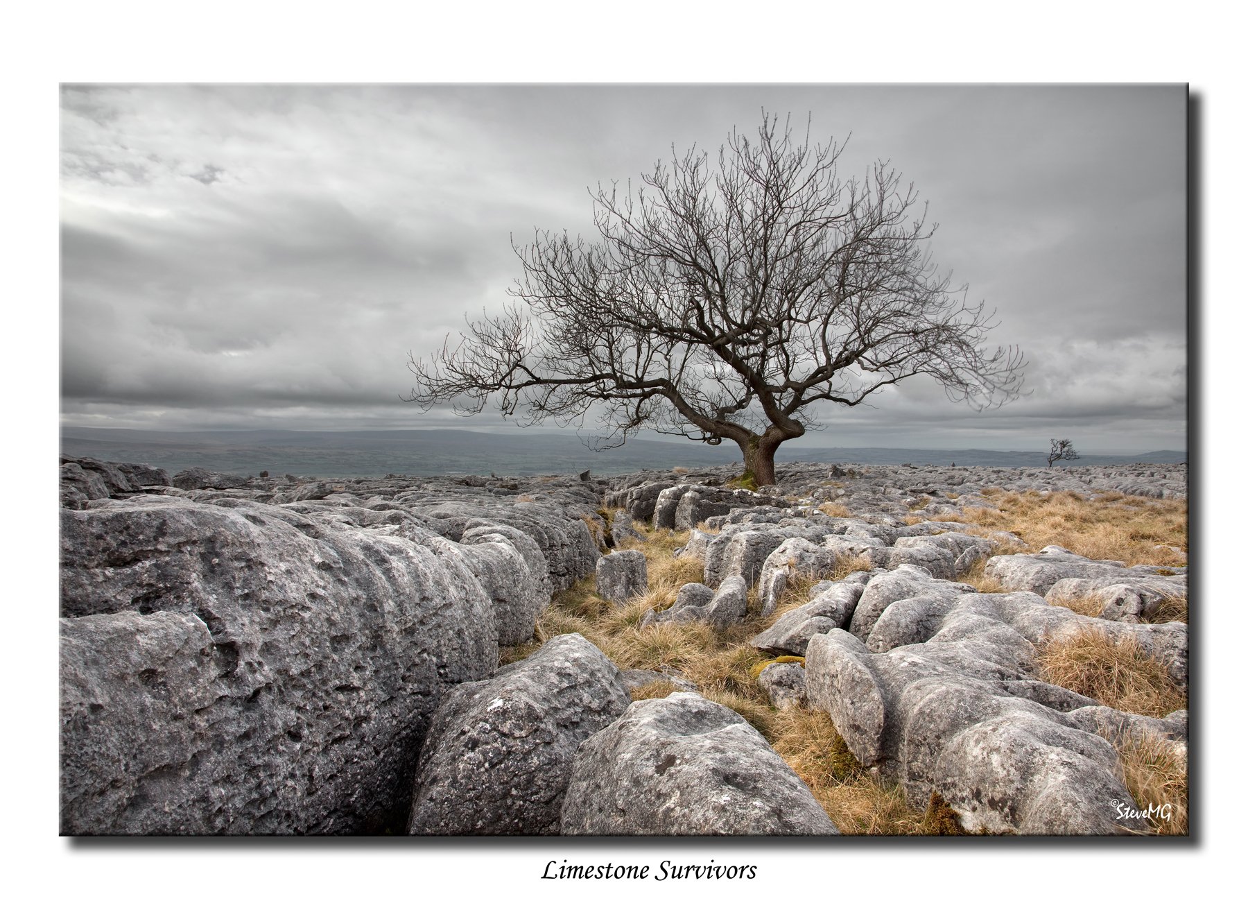
Land of Limestone
The Yorkshire Dales National Park really is limestone country, you can see features such as scars potholes and pavements like this at the foot of Ingleborough.
A set of side dumps in limestone service sits on the scale track at Proctor. I waited a while hoping to get the train in better light, but they left before that happened. That did give me the chance to get them in another location.
Geology: this limestone was formed beneath the waters of the Mediterranean Sea. The continent of Europe and the continent of Africa are v - e - r - y g - r - a - d - u - a - l - l - y meeting each other over millions of years. So, the limestone is being forced up.
Capo Caccia
Capo Caccia is situated a few kilometres from Alghero, on the southern point of a huge limestone triangle that wedges out into the sea. There are characteristic, impressive cliffs (nearly 300 m high) on its west side.
Capo Caccia is renowned for the underground labyrinth of mysterious caves discovered in 1700. The most famous one is Grotta di Nettuno (2500 m long) that can be reached by sea or on ground climbing the 656 steps of Escala del Cabirol that lead to the cave. There is a beautiful transparent lake (La Marmora) with two small sandy beaches just at its entrance.
Capo Caccia is one of the wildest places in Sardinia. Inland, there is an extraordinary natural reserve established by Italian Botanic Association in 1970 and covering nearly three thousand hectares. It's a marvellous garden full of plants unique to the world. Capo Caccia is frequented by big birds of prey. Many of them are quite rare in other parts of the world.
Travelling towards the north you will come upon Porto Conto, a beautiful bay protected from winds by high cliffs. Nearby, past the village of Fertilia, the prehistoric Necropolis of Anghelu Ruju with 36 graves and the Nuraghe Palmavera can be visited. These are some of the most antique testimonies of the past in this area.
Capo Caccia is the perfect place for diving enthusiasts - there are about 20 different immersion points accessible thanks to scuba diving guides. The sea water is crystal-clear and the submerged caves are full of colourful fish and sea plants including red corral. Most of the underwater excursions are accessible by everybody and the average depth is 25 meters. Some of them are reserved only for the most expert scuba divers.
Capo Caccia offers an ideal environment for other sports enthusiasts for the likes of swimming to aqua gym, from windsurfing to water skiing and canoeing, from mountain biking to horse riding or hiking.
Numerous boat excursions are organised, for example the Riviera del Corallo excursion with its wonderful landscape used as a scenery for many films, Faradada Island (Isola Faradada) to the west of Capo Caccia, Piana Island to the north, Porto Conte Bay with its beautiful beaches, Punta del Giglio and the most spectacular excursions in the famous caves Grotta di Nettuno, Grotta Verde and Grotta dei Ricami.
There are many places and monuments to explore inland such as the antique towers (Torre del Bollo, Torre del Tramariglio, Torre del Pegna) or the Nuraghe Santimbena together with ruins of a Roman villa, and finally, the picturesque old town of Alghero.
Sardiniatourism.com