View allAll Photos Tagged Further
Bethesda Maryland, November 12, 2017. More than a hundred activists, politicians and supporters gathered at the historic Macedonia Baptist Church for a rally and march to oppose the further desecration of the old Moses African Cemetery by developers and Montgomery County "planning" officials. This sacred ground is currently an ugly asphalt parking lot and has been approved to be the site of a new parking garage. We support the purchase of the cemetery land by the County for eventual restoration and the establishment of a museum dedicated to local African American cultural heritage.
Further picture of Strathclyde Police RPU BMW 5 series, and Scottish Ambulance Service (SAS) DTU, taken at a slight angle to show the front of the SAS DTU, complete with service crest on the bonnet.
(further information and pictures you can get by clicking on the link at the end of page!)
Mariahilferstraße
Mariahilferstraße, 6th, 7th, 14th and 15th, since 1897 (in the 6th and 7th district originally Kremser Sraße, then Bavarian highway, Laimgrubner main road, Mariahilfer main street, Fünfhauserstraße, Schönbrunnerstraße and Penzinger Poststraße, then Schönbrunner Straße), in memory of the old suburb name; Mariahilf was an independent municipality from 1660 to 1850, since then with Gumpendorf, Magdalenengrund, Windmühle and Laimgrube 6th District.
From
aeiou - the cultural information system of the bm: bwk
14,000 key words and 2000 pictures from history, geography, politics and business in Austria
Mariahilferstraße, 1908 - Wien Museum
Mariahilferstraße, 1908
Picture taken from "August Stauda - A documentarian of old Vienna"
published by Christian Brandstätter - to Book Description
History
Pottery and wine
The first ones who demonstrably populated the area of today's Mariahilferstraße (after the mammoth) were the Illyrians. They took advantage of the rich clay deposits for making simple vessels. The Celts planted on the sunny hills the first grape vines and understood the wine-making process very well. When the Romans occupied at the beginning of our Era Vienna for several centuries, they left behind many traces. The wine culture of the Celts they refined. On the hill of today's Mariahilferstraße run a Roman ridge trail, whose origins lay in the camp of Vindobona. After the rule of the Romans, the migration of peoples temporarily led many cultures here until after the expulsion of the Avars Bavarian colonists came from the West.
The peasant Middle Ages - From the vineyard to the village
Thanks to the loamy soil formed the winery, which has been pushed back only until the development of the suburbs, until the mid-17th Century the livelihood of the rural population. "Im Schöff" but also "Schöpf - scoop" and "Schiff - ship" (from "draw of") the area at the time was called. The erroneous use of a ship in the seal of the district is reminiscent of the old name, which was then replaced by the picture of grace "Mariahilf". The Weinberg (vineyard) law imposed at that time that the ground rent in the form of mash on the spot had to be paid. This was referred to as a "draw".
1495 the Mariahilfer wine was added to the wine disciplinary regulations for Herrenweine (racy, hearty, fruity, pithy wine with pleasant acidity) because of its special quality and achieved high prices.
1529 The first Turkish siege
Mariahilferstraße, already than an important route to the West, was repeatedly the scene of historical encounters. When the Turks besieged Vienna for the first time, was at the lower end of today Mariahilferstrasse, just outside the city walls of Vienna, a small settlement of houses and cottages, gardens and fields. Even the St. Theobald Monastery was there. This so-called "gap" was burned at the approach of the Turks, for them not to offer hiding places at the siege. Despite a prohibition, the area was rebuilt after departure of the Turks.
1558, a provision was adopted so that the glacis, a broad, unobstructed strip between the city wall and the outer settlements, should be left free. The Glacis existed until the demolition of the city walls in 1858. Here the ring road was later built.
1663 The new Post Road
With the new purpose of the Mariahilferstrasse as post road the first three roadside inn houses were built. At the same time the travel increased, since the carriages were finally more comfortable and the roads safer. Two well-known expressions date from this period. The "tip" and "kickbacks". In the old travel handbooks of that time we encounter them as guards beside the route, the travel and baggage tariff. The tip should the driver at the rest stop pay for the drink, while the bribe was calculated in proportion to the axle grease. Who was in a hurry, just paid a higher lubricant (Schmiergeld) or tip to motivate the coachman.
1683 The second Turkish siege
The second Turkish siege brought Mariahilferstraße the same fate. Meanwhile, a considerable settlement was formed, a real suburb, which, however, still had a lot of fields and brick pits. Again, the suburb along the Mariahilferstraße was razed to the ground, the population sought refuge behind the walls or in the Vienna Woods. The reconstruction progressed slowly since there was a lack of funds and manpower. Only at the beginning of the 18th Century took place a targeted reconstruction.
1686 Palais Esterhazy
On several "Brandstetten", by the second Turkish siege destroyed houses, the Hungarian aristocratic family Esterhazy had built herself a simple palace, which also had a passage on the Mariahilferstrasse. 1764 bought the innkeeper Paul Winkelmayr from Spittelberg the building, demolished it and built two new buildings that have been named in accordance with the Esterhazy "to the Hungarian crown."
17th Century to 19th Century. Fom the village to suburb
With the development of the settlements on the Mariahilferstraße from village to suburbs, changed not only the appearance but also the population. More and more agricultural land fell victim to the development, craftsmen and tradesmen settled there. There was an incredible variety of professions and trades, most of which were organized into guilds or crafts. Those cared for vocational training, quality and price of the goods, and in cases of unemployment, sickness and death.
The farms were replaced by churches and palaces, houses and shops. Mariahilf changed into a major industrial district, Mariahilferstrasse was an important trading center. Countless street traders sold the goods, which they carried either with them, or put in a street stall on display. The dealers made themselves noticeable by a significant Kaufruf (purchase call). So there was the ink man who went about with his bottles, the Wasserbauer (hydraulic engineering) who sold Danube water on his horse-drawn vehicle as industrial water, or the lavender woman. This lovely Viennese figures disappeared with the emergence of fixed premises and the improvement of urban transport.
Private carriages, horse-drawn carriages and buggies populated the streets, who used this route also for trips. At Mariahilferplatz Linientor (gate) was the main stand of the cheapest and most popular means of transport, the Zeiselwagen, which the Wiener used for their excursions into nature, which gradually became fashionable. In the 19th Century then yet arrived the Stellwagen (carriage) and bus traffic which had to accomplish the connection between Vienna and the suburbs. As a Viennese joke has it, suggests the Stellwagen that it has been so called because it did not come from the spot.
1719 - 1723 Royal and Imperial Court Stables
Emperor Charles VI. gave the order for the construction of the stables to Johann Bernhard Fischer von Erlach. 1772 the building was extended by two houses on the Mariahilferstrasse. The size of the stables still shows, as it serves as the Museum Quarter - its former importance. The Mariahilferstraße since the building of Schönbrunn Palace by the Imperial court very strongly was frequented. Today in the historic buildings the Museum Quarter is housed.
The church and monastery of Maria Hülff
Coloured engraving by J. Ziegler, 1783
1730 Mariahilferkirche
1711 began the renovation works at the Mariahilferkirche, giving the church building today's appearance and importance as a baroque monument. The plans stem from Franziskus Jänkl, the foreman of Lukas von Hildebrandt. Originally stood on the site of the Mariahilferkirche in the medieval vineyard "In Schoeff" a cemetery with wooden chapel built by the Barnabites. Already in those days, the miraculous image Mariahilf was located therein. During the Ottoman siege the chapel was destroyed, the miraculous image could be saved behind the protective walls. After the provisional reconstruction the miraculous image in a triumphal procession was returned, accompanied by 30,000 Viennese.
1790 - 1836 Ferdinand Raimund
Although in the district Mariahilf many artists and historical figures of Vienna lived , it is noticeable that as a residence they rather shunned the Mariahilferstraße, because as early as in the 18th Century there was a very lively and loud bustle on the street. The most famous person who was born on the Mariahilferstrasse is the folk actor and dramatist Ferdinand Raimund. He came in the house No. 45, "To the Golden deer (Zum Goldenen Hirschen)", which still exists today, as son of a turner into the world. As confectioners apprentice, he also had to visit the theaters, where he was a so-called "Numero", who sold his wares to the visitors. This encounter with the theater was fateful. He took flight from his training masters and joined a traveling troupe as an actor. After his return to Vienna, he soon became the most popular comedian. In his plays all those figures appeared then bustling the streets of Vienna. His most famous role was that of the "ash man" in "Farmer as Millionaire", a genuine Viennese guy who brings the wood ash in Butte from the houses, and from the proceeds leading a modest existence.
1805 - 1809 French occupation
The two-time occupation of Vienna by the French hit the suburbs hard. But the buildings were not destroyed fortunately.
19th century Industrialization
Here, where a higher concentration of artisans had developed as in other districts, you could feel the competition of the factories particularly hard. A craftsman after another became factory worker, women and child labor was part of the day-to-day business. With the sharp rise of the population grew apartment misery and flourished bed lodgers and roomers business.
1826
The Mariahilferstraße is paved up to the present belt (Gürtel).
1848 years of the revolution
The Mariahilferstraße this year was in turmoil. At the outbreak of the revolution, the hatred of the people was directed against the Verzehrungssteuerämter (some kind of tax authority) at the lines that have been blamed for the rise of food prices, and against the machines in the factories that had made the small craftsmen out of work or dependent workers. In October, students, workers and citizens tore up paving stones and barricaded themselves in the Mariahilfer Linientor (the so-called Linienwall was the tax frontier) in the area of today's belt.
1858 The Ring Road
The city walls fell and on the glacis arose the ring-road, the now 6th District more closely linking to the city center.
1862 Official naming
The Mariahilferstraße received its to the present day valid name, after it previously was bearing the following unofficial names: "Bavarian country road", "Mariahilfer Grund Straße", "Penzinger Street", "Laimgrube main street" and "Schönbrunner Linienstraße".
The turn of the century: development to commercial street
After the revolution of 1848, the industry displaced the dominant small business rapidly. At the same time the Mariahilferstraße developed into the first major shopping street of Vienna. The rising supply had to be passed on to the customer, and so more and more new shops sprang up. Around the turn of the century broke out a real building boom. The low suburban houses with Baroque and Biedermeier facade gave way to multi-storey houses with flashy and ostentatious facades in that historic style mixture, which was so characteristic of the late Ringstrasse period. From the former historic buildings almost nothing remained. The business portals were bigger and more pompous, the first department stores in the modern style were Gerngross and Herzmansky. Especially the clothing industry took root here.
1863 Herzmansky opened
On 3 March opened August Herzmansky a small general store in the Church Lane (Kirchengasse) 4. 1897 the great establishment in the pin alley (Stiftgasse) was opened, the largest textile company of the monarchy. August Herzmansky died a year before the opening, two nephews take over the business. In 1928, Mariahilferstraße 28 is additionally acquired. 1938, the then owner Max Delfiner had to flee, the company Rhonberg and Hämmerle took over the house. The building in Mariahilferstrasse 30 additionally was purchased. In the last days of the war in 1945 it fell victim to the flames, however. 1948, the company was returned to Max Delfiner, whose son sold in 1957 to the German Hertie group, a new building in Mariahilferstrasse 26 - 30 constructing. Other ownership changes followed.
1869 The Pferdetramway
The Pferdetramway made it first trip through the Mariahilferstraße to Neubaugasse.
Opened in 1879 Gerngroß
Mariahilferstraße about 1905
Alfred Gerngross, a merchant from Bavaria and co-worker August
Herzmanskys, founded on Mariahilferstrasse 48/corner Church alley (Kirchengasse) an own fabric store. He became the fiercest competitor of his former boss.
1901 The k.k. Imperial Furniture Collection
The k.k. Hofmobilien and material depot is established in Mariahilferstrasse 88. The collection quickly grew because each new ruler got new furniture. Today, it serves as a museum. Among other things, there is the office of Emperor Franz Joseph, the equipment of Emperor Maximilian of Mexico from Miramare Castle, the splendid table of Charles VI. and the furniture from the Oriental Cabinet of Crown Prince Rudolf.
1911 The House Stafa
On 18 August 1911, on the birthday of Emperor Franz Joseph, corner Mariahilferstraße/imperial road (Kaiserstraße) the "central palace" was opened. The construction by its architecture created a sensation. Nine large double figure-relief panels of Anton Hanak decorated it. In this building the "1st Vienna Commercial sample collective department store (Warenmuster-Kollektivkaufhaus)", a eight-storey circular building was located, which was to serve primarily the craft. The greatest adversity in the construction were underground springs. Two dug wells had to be built to pump out the water. 970 liters per minute, however, must be pumped out until today.
1945 bombing of Vienna
On 21 February 1945 bombs fell on the Mariahilferstrasse, many buildings were badly damaged. On 10th April Wiener looted the store Herzmansky. Ella Fasser, the owner of the café "Goethe" in Mariahilferstrasse, preserved the Monastery barracks (Stiftskaserne) from destruction, with the help other resistance fighters cutting the fire-conducting cords that had laid the retreating German troops. Meanwhile, she invited the officers to the cafe, and befuddled them with plenty of alcohol.
After a lot of further thought we have decided to leave Japan.
This is not an easy decision for us to make and explains why I've not been as prolific on Flickr these past few months, as most of our free time has been spent deciding what we plan to do given the situation here in Japan.
I mentioned in an earlier post that I'm not one to run away from a fight, but when the fight is rigged against you to begin with, it can be hard justifying the long hard slog. Note that its not as dangerous here as a few may say, but it certainly isn't as safe as many believe. We're erring on the side of caution and are leaving as a result. We're viewing this as an opportunity to give the kids the experience they need living in the US as they are after all Texans as well as Japanese ;-)
We leave next Friday (July 15th) for a previously planned trip to Texas to drop the boys off at Camp Champions for 3 weeks. Chizuko and I will then go around California and Texas to determine where we will live for the next few years. Irvine, CA and Austin, TX are the top two candidates. Once a decision has been made, accommodations acquired, and boys in school, *then* I will have time to get back to my regularly scheduled Flickr postings and comments!
Thanks in advance for everyone's support and comments over these past few months! I haven't forgotten y'all, just been 100% focused on this decision we've made.
Non-HDR shot taken of a spectacular sunset from the balcony of our apartment here in Tokyo. One of the last we'll be seeing for quite some time.
Tokyo, Japan.
The ravages of time are evident in these tombstones. This is the graveyard of St John's Church at Richmond, Tasmania, one of - if not the oldest - graveyards in Tasmania. (Here is a link for further reading and history . . . www.puginfoundation.org/assets/Richmond_Essay.pdf).
These stonemasons knew their craft and were able to fashion intricate work. The ravages of time are evident in the lichen that is growing on this tombstone as well as the other tombstones too. The lettering on the gravestones is another wonder of their craft too, and nowadays, not so much sandstone headstones are used but that of marble, and in different hues and shades.
I find graveyards fascinating to visit - there is much history tied up here!! Some headstones reveal and age well into the 90s or maybe even the 100s, some are in the 80s, 70s and backwards down the scale. Then there are the very young children from babies to upwards and I feel saddened that these children did not get to experience what life was all about. Or maybe it was their destiny that they come into this world for a short time, then flee on spiritual wings to a life that is bereft os suffering, a release from pain and hardship.
Some gravestones carry a verse, or a brief glimpse into that person's life.
Having been diagnosed with prostate cancer I am now aware of the statistics for my age group - one in 7 in Australia and I presume it is similar around the world. Then there are all the other forms of cancer that abound. Success rates for myself are very high, whereas there is a lovely lady who came into the "home" where we are staying and, sadly, she is slipping away and does not have long to live and she was a beautiful and friendly lady. Rosey and I and the other residents enjoyed her company very much!! We feel for her husband, another champion, and her family. One thing we can be certain of, we are on this earth for a given amount of time, we came into this world with nothing and we shall leave this world with nothing . . .
Last night (Wednesday) we decided to have a barbecue and most of the residents attended, around 20 of us, some single, mostly with our spouses and we got to meet spouses of patients we had not met before, and it was a wonderful celebration of life. Our meal consisted of a traditional Aussie barbecue with steak, chops, sausages, fish (our choice and Atlantic salmon cutlets at that - delicious) and to accompany these delicacies were salads and to finish off a trifle, cheese cake and ice cream. All went down the hatch extremely well, we can vouch for that!!! So in our world, although the different patients have been diagnosed with various forms of cancer, together we laughed and joked the night away.
Even in the waiting room when we are awating our ray treatment, we have established wonderful friendships with people who have chosen to be day patients and it is always a joy to see each other, although it is only for a 1/2 hour each day, and again we laugh and joke which is the way it ought to be!!!!
Rosey and I wish you a Very Merry Christmas and a wonderful and safe 2013. We hope your dreams, your pathway, and your lives will be trouble free, that you are continually blessed by God in all that you do and achieve. Certainly, like our cancer mates here we both feel very close and attached to you all and thanks for being our wonderful and faithful friends on Flickr. What a journey!!! And if you are going through a difficult patch, we hope and pray it will be pain free and victory will be yours in the end!!! Love and God bless you all and may 2013 be a wonderful journey for you all!!
In closing we had a wonderful Christmas Day together in Griffith, 180 klms away from Wagga where my treatment takes place. It was great to come home and have a quiet time with just us, no visitors which we wanted and time to ourselves, relaxing and watching TV (Andre Rieu was one of the wonders) and what a great day we had. We also hope your Christmas time was very special for you all and that 2013 will be a wonderful journey for you all!!!!!
Clive and Rosey xxxxxxxxx
(for further pictures and information please contact the link at the end of page!)
Maria Theresa monument
Maria Theresa monument in Vienna
Maria Theresa Square
The Maria Theresa monument is the most important ruler monument of the Habsburg monarchy in Vienna. It is reminiscent of the Empress Maria Theresa, who ruled from 1740 to 1780, and is since 1888 on the Maria Theresa Square on the Vienna ring road (Castle Square - Burgring) between the then Imperial Museums, in 1891 opened the Kunsthistorisches Museum (Museum of Art History) and in 1889 opened the Natural History Museum (Naturhistorisches Museum), in front of the background of the Museum Quarter, then the imperial stables. This by Tritons and Najad Fountains accompanied Ensemble monument counts to the UNESCO World Heritage Site Historic Centre of Vienna.
Historical Background
View from the top (2010)
The Empire of Austria in 1859 and 1866 lost Lombardy and Veneto to the new Kingdom of Italy. It was in 1866 forced to resigne after the defeat of the German war, the Prussians had triggered by violation of the rules of the German Confederation from Germany, which in 1871 was constituted as German Empire under a new empire. In 1867 Emperor Franz Joseph I. in Compromise with Hungary had to agree to the formal division of the empire into a ruled from Vienna cisleithanian and ruled from Budapest transleithanian half of the Empire, with Hungary increasingly presenting itself not as a part of the empire, but as a largely independent state. en.wikipedia.org/wiki/Leitha
During the World Exhibition 1873 in Vienna an economic crisis had occurred, the "founders' crash - Gründerkrach" that devalued liberalism as the leading political movement and new mass parties, for the time being, the Christian Social Party, and later the Social Democrats, putting forth. In addition, more and more national movements were felt in the multiethnic state.
Those centrifugal and the imperial power eroding tendencies one would counteract by patriotic appeals to splendor and glory of the empire. At the since 1858 under construction and in 1865 opened new Vienna ring road around the old town was offered the chance. On the Maria Theresa Square the center facing adjoining Heldenplatz outside the Hofburg in 1860 and 1865 monuments of the two most important generals of the monarchy were built. For the Maria Theresa square, which with the Heldenplatz should form an Imperial Forum, it was a good occasion to erect a monument to the historical mother of the nation. She had by her marriage to Francis Stephen of Lorraine and his election as emperor, the Roman-German Empire brought back to Vienna and the continuation of the dynasty, now as House of Habsburg-Lorraine, secured. She referred to a time when the development of the monarchy was not dependent on any political party nor on national political considerations, but by the wisdom of the rulers. Her reputation and popularity should radiate to the current empire.
The monument
Gypsum model of a draft of the monument
Maria Theresa surrounded by the allegories of the cardinal virtues
For the execution of the sculptures in 1874 the three sculptors Johannes Benk, Carl Kundmann and Caspar Zumbusch submitted designs. Emperor Franz Joseph I decided for Zumbusch, with his student Anton Brenek around 13 years working on the bronze sculptures, which have a total weight of 44 tons. Carl von Hasenauer designed the architecture of the monument.
With the base, the monument covers an area of 632 square meters and is 19.36 m high, on top the seated figure of the Empress with 6 m height. Base and chain pedestal consist of Mauthausen granite from Enghagen in Upper Austria, pedestal and base of brown hornblende granite from Petersburg-Jeschitz at Pilsen in the Czech Republic, the columns of serpentinite from Wiesen near Sterzing in South Tyrol.
The program's content for the monument came from Alfred von Arneth, director of the Imperial House, Court and State Archives. The monarch herself sits on her throne at the top, in the left hand a scepter and the Pragmatic Sanction, the State and the Constitutional Treaty, her allowing the rule in the Habsburg lands as woman, saluting with the right hand the people. Around the throne on the cornice are sitting as allegorical personifications of the cardinal virtues of justice, strength, gentleness and wisdom four female figures .
At the four sides of the base each is located a circular field with a relief and before that a freestanding statue in thematic context:
The consultants of the Archduchess are represented by Wenzel Anton Kaunitz as a statue and Johann Christoph von Bartenstein, Gundakar Thomas Graf Starhemberg and Florimond Claude of Mercy-Argenteau in relief, the background shows the Gloriette in the garden of Schonbrunn Palace.
For the administration stand Friedrich Wilhelm von Haugwitz (statue) and Antal Grassalkovich I, Samuel Brukenthal, Paul Joseph of Riegger, Karl Anton von Martini and Joseph von Sonnenfels in a consulting room in the Imperial Palace.
For the military stand Joseph Wenzel I (statue) with Franz Moritz von Lacy, Andreas Hadik of Futak and Franz Leopold of Nádasdy in front of the castle in Wiener Neustadt, in which in 1752 the Theresa Military Academy was established.
Science and art are represented by the physician Gerard van Swieten (statue), the numismatist Joseph Hilarius Eckhel, the historian György Pray and the composer Christoph Willibald Gluck, Joseph Haydn and the as child represented Wolfgang Amadeus Mozart in front of the Old University.
Consultants
Management
Military
Science and Art
On the diagonal axes surround equestrian statues of four commanders from the era of Maria Theresa the monument: Leopold Joseph von Daun (1705-1766), Ludwig Andreas von Khevenhüller (1683-1744), Gideon Ernst von Laudon (1717-1790) and Otto Ferdinand von Abensperg and Traun (1677-1748).
Leopold Joseph von Daun
Ludwig Andreas von Khevenhüller
Gideon Ernst von Laudon
Otto Ferdinand von Abensperg and Traun
Open base during the renovation (2008)
The monument is being totally renovated since October 2008. In a first step, the base whose granite cladding and the foundation were restored. Under the monument in the course of the work a 600-square-foot brick vault was discovered as a supporting structure that is similar to already known components underneath the equestrian statues on Heroes' Square. In a second step, the stone and metal surfaces are being rehabilitated until probably October 2013.
Reception
The monument in 1888
Maria Theresa Square in 1900
Further new vehicles for Dumfries & Galloway Council are a pair of MCV Evotor bodied Volvo B8Rs to PSVAR spec, both based at Stanrare for school bus use.
As my Dad was 100 yards further down the platform and took another shot I know that 40001 is about to run through York with a return Scarborough to Stoke Excursion on the 28th of May 1977.
Repository: California Historical Society
Date: 1859 December 9.
Publication Note: [Stockton] : San Joaquin Republican Print., 1859.
Physical Description: 1 sheet ([1] p.) ; 21 x 13 cm.
Call Number: Vault B-029
Digital object ID: Vault_B-029.jpg
Preferred Citation: Dancing school: Mr. S.J. Millington, Pioneer teacher of California ... introductory lesson in Mr. Gall's Hall ... for further particulars, inquire at the Weber House, Vault B-029, courtesy, California Historical Society, Vault_B-029.jpg.
For more CHS digital collections: digitallibrary.californiahistoricalsociety.org
Further down the stream in normal livery , seen here in Blackpool now wearing a red livery is Den Caney E680UNE a Leyland Tiger / Plaxton Paramount 3200 C53F.
Picked up a Zenit EM at a car boot sale for £5 and tried it out with my Tair-11A 135mm f2.8 and some expired Kodacolor 200.
Processed at home with Tetenal C-41 kit.
(for further information or pictures please go to the end of page and click on the link!)
The Congregation of the Servants of the Sacred Heart of Jesus
The Congregation of the Servants of the Sacred Heart of Jesus was founded in 1866 by Abbè Peter Victor Brown in Paris.
On the advice of Baron Jaromir Mundy (one of the later founders of the Vienna Ambulance Company), Viennese medical officer and Maltese, who the Sacred Heart sisters became to know and to appreciate during the Franco-German war in a military hospital, summoned the then head of the Rudolf Foundation (Rudolfstifting), Mr. Director Boehm, the Sacred Heart sisters for nursing to Vienna in his hospital.
1873 arrived 13 sisters in Vienna and began their ministry to the sick. Due to the increasing number of sisters the construction of today's mother house (the provincial house at the time) in 1890 in the Keinergasse became necessary. This building which houses the oldest part of the hospital is now a protected monument, as well as church, monastery and "school".
1906 the Sacred Heart Church was consecrated and was followed in 1931 by the opening of the school building with day-care center (kindergarten and nursery).
During World War Second were confiscated all nonessential rooms of the Convent of the Wehrmacht for a military hospital. Our sisters took over the care of the wounded soldiers. From this institution was established in 1945 the private Sacred Heart Hospital (now 141 beds).
In 1989 the staff residence has been given over to its purpose, and 11 years later, in the holy year 2000, followed the tract in the Rabengasse, which is equipped with an interdisciplinary monitoring unit.
According to the motto "serve in love", the sisters, since the founding of the Congregation, make all possible efforts in order to guarantee the welfare of the children, sick and elderly.
Order and hospital chronicle at a glance
1866 - Founded Abbé Victor Brown, a priest from Lorraine, the Congregation of the Servants of the Most Sacred Heart of Jesus. The sisters took care of the poor, abandoned, old and sick people and of neglected children.
1873 - 13 sisters come to Vienna in the Rudolf Foundation for the care of the sick and home nursing.
1874 - Opening of a branch in Gainfarn (Lower Austria) with the take-over of a children's home (Kinderbewahranstalt).
1875 - Sisters from the London house come to Vienna. Acquisition of Crown Prince Rudolf Children's Hospital.
1877 - Appeal of the sisters to St. Anna Children's Hospital/Vienna.
1879 - Acquisition of the house as the first property in Vienna, which is now the provincial house in Austria. Establishment of the first novitiate in Austria
1880 - Takeover of the nursing service in the Epidemic hospital, Triesterstraße/Vienna.
1883 - The sisters are appointed to the by the Countess Malfatti founded St. Josefs-Greisenasyl/Wien (old age asylum).
1884 - The nursing service in the community hospital Bad Vöslau is transferred to the sisters.
1886 - Due to the growth of the sisters, new acquisition of a larger provincial house in Vienna/Ober St. Veit, Himmelhof.
1888 - Takeover of the nursing service in the Kaiser-Franz -Josef Hospital/Vienna and the Wiedner Hospital/Vienna.
1890 - Laying of the foundation stone of the new provincial house in the Keinergasse/Vienna.
Vocation of the Sisters to the Nursing Institute Confraternität.
1892 - Takeover of the municipal poorhouse Scheibbs/Lower Austria and opening of a needlework school.
1893 - Opening of a needlework school and a kindergarten in the Mother House.
1896 - Establishment of a branch in Gaweinstal/Lower Austria .
1897 - Takeover of nursing in Inquisitenspital/Vienna.
1898 - Care of plague victims in the Kaiser-Franz-Josef Hospital.
1899 - Takeover of nursing in the General Hospital/Vienna.
1900 - Extension of the Mother House
1904 - Ground-breaking ceremony of the Sacred Heart Church in the 3rd District of Vienna. Commencement of operations in the poor house and in kindergarten in Kallwang/Styria.
1905 - Takeover of care in the poor house/Laa an der Thaya/Lower Austria. Inauguration of the extension of the Mother House on the Landstraßer Hauptstrasse/Vienna.
1906 - Inauguration of the Sacred Heart Church, Vienna.
1907
-
1912 - Founding of several branches throughout Austria.
1911
-
1913 - During this time, nurses are in Serbia at the war front.
1914 - Takeover of Preyerschen Children's Hospital in the 10th District of Vienna.
1919 - Establishment of a day-care center in the Mother House. Opening of an evening home for girls as young as 14 years. Acquisition of a recovery house in Niederhollabrunn.
1926 - State recognition of the trade school in the Mother House.
1932 - Death of the Superior, Chancellor Dr. Seipel.
1934 - Takeover of care in the General Army Hospital/Vienna. Purchase of a recovery house in St. Reginald/Krems.
1938 - Nazi Party seizes the school building. Expulsion of the Sisters of the kindergartens in Austria and Germany.
1939 - Second World War. By the Nazi Party follows the confiscation of the monastery. In the Mother House establishment of a military hospital. Care of the wounded in hospitals and sick bays.
1944 - In air raids on Vienna the Mother House was bombed. Two sisters killed, church and a part of the house badly damaged. In the bombing of the Franz-Josef-Spital killed five sisters.
1945 - End of war. At the Mother House follows the re-designation of the Reserve Military Hospital into the Sacred Heart Hospital. Reopening of kindergartens and day-care center in the Mother House.
1946 - Reconstruction of the Mother House.
1956 - 50th jubilee of its existence of the Sacred Heart Church.
1966 - The last sisters leave the Rudolf Foundation, in which the activity has begun in Vienna.
1970 - Inauguration of the new Austrian Province House in Mödling.
1971 - Annex to Sacred Heart Hospital.
1973 - 100 years Servants of the Sacred Heart of Jesus in Vienna.
1988 - Construction of a personal residence.
1990 - First CT in a small hospital.
1991 - Clinic for Physical Therapy.
1992 - Orthopaedic Department (only department in the 3rd district)
1993 - Surgical Outpatient Clinic/Department of Conservative orthopedics.
1994 - Annex to Sacred Heart Hospital.
1995 - Renovation of the kitchen of the hospital and 50-year anniversary.
1997 - Bed elevator Keinergasse.
1999 - Spin-off and conversion into a limited company.
2000 - Annex Rabengasse (new surgical classification).
2001 - Geriatrics (only department in the 3rd district).
2003 - Annex for electric supply.
2004 - Official recognition of four interdisciplinary monitoring beds after 30 years of voluntary service. Fire alarm system throughout the hospital.
2005 - Operation Room 3.
2006 - Operation Room 1 + 2. Completion of conversion of all departments.
2007 Integration into the Vincent Group.
(to see further pictures and read other information please go to the end of page!)
Flaktowers
Flakturm, Arenbergpark
Picture: Flakturm, Arenbergpark
The Vienna flak towers are six large, of reinforced concrete erected defensive and protective structures in Vienna, which were built in the years 1942-1945 as giant bomb shelters with fitted anti-aircraft guns and fire control. The architect of the flak towers was Friedrich Tamms (1904-1980).
Flakturm, Arenbergpark
Image: Terrace of the flak tower in Arenbergpark
The system of the Vienna flak towers consists as a whole of six buildings, three turrets, each with a Feuerleitturm (fire-control tower). The three bunker pairs are arranged in a triangle in the approximate middle of which the Stephansdom is situated. The towers are of different heights, but their upper platforms are in exactly the same altitude, so that an overall coordination of air defense was possible. The maximum operating radius of the four main guns (12.8 cm twin) of each tower was under ideal conditions 20 km. The smaller platforms of combat and fire-control towers were provided for 2 cm anti-aircraft guns, but they were never used in Vienna. In addition to its military crew the flak towers in Vienna served as makeshift hospitals, housed radio stations and partly war-relevant technical companies and offered on a large scale air raid shelters for the population.
Flakturm Augarten
Picture: Flakturm, Augarten
After the war, the Red Army undertook blasting tests in Gefechtsturm (flak tower with battle platform) Augarten, but a removal of the towers failed because of the proximity to residential areas. Nowadays, a removal of the towers would be possible, but now existing only an official decision as to the two anti-aircraft towers in Augarten from 5 April 2000 (GZ 39.086/2/2000) because all six buildings ex lege have been put under monument protection. Today, the towers are partially owned by the City of Vienna and partly owned by the Republic of Austria. There were repeatedly attempts to rebuild the flak towers and make it usable. The ideas range from depot for important backup data to a café or hotel.
Planning
Flakturm, Arenbergpark
Picture: Flakturm, Arenbergpark - Notstiege (Emergency flight of stairs)
Flakturm, Arenbergpark
Picture: Flakturm, Arenbergpark
Elevator shaft to the left, original instructions for lift usage right
After the battles of World War II also spread more and more to Vienna, Adolf Hitler ordered on 9 September 1942 the construction of flak towers in Vienna. The Air Force leadership provided for this purpose as building sites the Schmelz (Vienna), the Prater and Floridsdorf but Hitler rejected these places since the city center would not have been adequately protected because of the large distances. After discussions with Reichsstatthalter (Reich Governor) Baldur von Schirach, the final locations were determined. Instead of the Augarten, however, was initially the Roßauer barracks under discussion. The decisive factor for the choice of the places were on the one hand, the easy availability of the building ground and on the other hand the possibility to establish railway connections. The plan provided after the victorious end of the war to disguise the flak towers with marble and devote them as monuments to the fallen German soldiers. As with all the flak towers Friedrich Tamms was responsible for the planning, he was represented in Vienna by Anton Ruschitzka, construction management held Franz Fuhrmann from Vienna's city building department. The military leadership rested with Major Wimberger, which, however, had no mission staff. The material procurement was carried out by the Organisation Todt.
Construction
Flakturm, Arenbergpark
Picture: Flakturm, Arenbergpark
Emergency Exit Photo: Flakturm, Arenbergpark
With the construction of the flak towers the companies Philipp Holzmann and Gottlieb Tesch were commissioned, smaller firms being integrated via joint ventures. Since the availability of local workers due to conscription declined steadily, more and more prisoners of war, foreign and forced laborers were used in the course of the war. Cement was delivered primarily from Mannersdorf at Leithagebirge, to a lesser extent from Rodaun (situated in the outskirts of Vienna). The gravel stemmed from the gravel pits Padlesak in Felixdorf and Gustav Haager at Heidfeld at the Bratislava railway (Pressburger Bahn), about in the area of today's airport Wien-Schwechat. Sand was delivered in ships over the Danube Canal, which is why in the area of Weißgerberlände sand silos of the United Baustoffwerke AG were built. In this area was already in 1918 a feeder track of the tram through the Drorygasse. Although this was already in 1925 shut down it was restored in 1941 and enlarged in the following year after the construction of a new silo to two tracks. For the then due to the excavation of the foundations coming up overburden, at the Kratochwijlestraße (then Weissenbachstraße) in 22 District was created a landfill, which also got a tram connection.
This report is based on an article in the
WIKIPEDIA - The Free Encyclopedia
and is licensed under the GNU license
Free Documentation Creative Commons CC -BY- SA 3.0 Unported.
On Wikipedia there is List of the authors Available .
de.wikipedia.org
The monstrous remnants of the "Third Reich"
District II (Leopoldstadt), anti-aircraft towers in the Augarten, tram line 31 from metro station Scots ring/Schottenring (U2, U4).
On 15 March 1938 gathered some 200 000 Wiener (Viennese people) on Heldenplatz in order to celebrate the "Anschluss" of Austria to the so-called fatherland Germany, something, since the end of the first World War I many had been longing for. Adolf Hitler himself appeared on the balcony of the Neue Burg and announced: "As leader and Chancellor of the German nation and the Reich I report before story now the entry of my home in the German Reich". Then he boarded a plane back to Germany, the rest, as they say, is history. A few years later the magnificent Heroes Square (Heldenplatz) was dug up to plant vegetables there, they needed food for the distraught people who suffered the privations in Hitler's zusammenbrechendem (breaking down) "millennial Reich".
Right: Gefechtsturm in the Augarten
In Leopoldstadt
Below: The Leitturm (control tower) in Arenbergpark
In III. District highway (Landstraße).
The already existing and sometimes bombastic Viennese architecture the occupiers seems to have pleased, no major buildings were added during their reign. On 9 September 1942, however, Hitler decreed that the city center of Vienna like in Berlin and Hamburg should be protected by some huge flak towers, three pairs should form a defensive triangle, St. Stephen's Cathedral was the center. 1943/44, the German troops began the construction of two flak towers in the Augarten and defaced in this way Austria's oldest still existing and in 1712 laid out baroque garden. Another pair of flak towers emerged in Arenberg Park in III. District (Landstraße), a third near the Mariahilferstraße (in Esterházypark and in the courtyard of the barracks Stiftskaserne) in the VI. resp. VII. District (Mariahilf/Neubau). The towers have been made of almost indestructible, 2.5 to 3.5 meters thick reinforced concrete and were self-sufficient, and they possessed their own water and power supply, first aid station and air filters if it should come to a gas attack. Each pair of flak towers contained a big, provided with a heavy gun flak tower and a smaller control tower for communication. The first is either a square tower in the style of a fortress, like the one in the Arenbergpark (neunstöckig - nine storeys), 41.6 meters high, 57 meters in diameter) or a round tower, in fact, sixteen -sided, as in the Augarten Park and the yard of the Stiftskaserne Barracks (zwölfstöckig - twelve storeys, 50.6 meters high, 43 meters in diameter). The heaviest artillery gun (105-128 mm) was standing on the roof, on the projecting balconies below there were lighter guns (20 to 30 millimeters). The Leittürme, from which the air defense was coordinated, were all rectangular (neunstöckig - nine storeys, 39 to 51.4 meters high, 24 to 39 feet long) and equipped with a lighter gun, they possessed communication devices and searchlights on the roof. Toward the of the war the towers only just were functional. They also served as air-raid shelter for the people in the area and each tower had space for 30 000 people. In the event that the war ended with a victory, the architect, the builder of the Reichsautobahn Friedrich Tamms, already had prepared designs to dress up the towers with black marble plates in which the names of the dead German soldiers should be engraved in gold letters. So the towers would also have been victory and war memorials (and thus in a strange way similar to the Mausoleum of Theodoric in Ravenna or the Castel de Monte in Apulia).
In the bureau of an architect of Berlin were even found plans to demolish the Jewish Quarter in the Leopoldstadt and to build a huge Nazi forum. Today, however, there is in Leopoldstadt again a thriving Jewish life and the flak towers are frozen monuments to the darkest times of Viennese history (in fact, the Russians tried to destroy the tower in Augarten with dynamite, which later on was mistaken for the vandalism of a few schoolboys, by mistake a forgotten weapon depot setting on fire).
In a famous quote Hitler Vienna compared with a pearl, which he wanted to give a socket. Towards the end of war, however, this socket only consisted of bombed-out buildings and abandoned flak towers, silent witnesses of the delusion of their builder. As a result, only the Leitturm was used in Esterhazy Park, and today in it the house of the sea (Zoo - Haus des Meeres) is accommodated. Outside there is a climbing wall with 25 different routes, and the vertical wall and the projecting balconies give a perfect imitation of an overhanging cliff of 34 meters of height. A conservatory (or biotope) with a miniature rain forest along with monkeys and birds has been added on one side; it is entered through a door that only with difficulty could be broken in the two and a half meters thick reinforced concrete, but this also ensures a uniform temperature for aquariums and vivariums in the tower.
The stable temperatures also have the Museum of Applied Arts (MAK) brought to take advantage of the flak tower in Arenberg Park as a magazine and occasional exhibition space; in the meantime it is known as Contemporary Art Tower (CAT).
A former air-raid shelter at the base of the Leitturm in Esterhazy Park now contains the Museum of Medieval legal history: the history of torture
Excerpts from
Duncan J. D. Smith; Only in Vienna
A travelling guide to strange places, secret places and hidden attractions
Translated from English by Brigitte Hilzensauer
Photographs by Duncan JD Smith
"The streets of Vienna are paved with culture, the streets of other cities with asphalt". Karl Kraus (1874-1936)
Vienna is certainly one of the greatest and also the most homogeneous capitals in Europe. And it is one of the most fascinating. The overabundance of travel guides that are out there to buy, presents the not too demanding visitor a magical (and easily accessible) abundance of museums, churches, palaces and culinary venues, and they recount the history of the city since the times of the Romans over those of the Habsburg Empire to the present.
Courtesy
Christian Brandstätter Verlag mbH
The publishing service for museums, businesses and public authorities
www.brandstaetter - verlag.at
Total, totalitarian, dead
Picture: Flak tower in 1943 /44, Augarten
At the zero point of the knowledge about the progress of the world stands since 11 September 2001 "Ground Zero". The debris field of the World Trade Center was used as a metaphor, which for its part marks a zero point. "Ground Zero" is called the area that lies in the center of a nuclear explosion. In Hiroshima and Nagasaki this area has been explored, the experiments that began with Albert Einstein's warning of a nuclear policy of Nazi Germany, were successful beyond measure. The name for the nuclear program, "Manhattan Project". With the beginning of the new millennium "Ground Zero" is real returned to where it had once taken its nominal starting point. The skyscraper obviously is able to stimulate the imagination of physicists, ballistics and aeronauts. In the skyscraper the obsessions of the 20th century are concentrated, self-sufficiency and utopia become one in the sky billowing tower. It is the exalted and the sublime. It provides a beacon, of the construction as well as of the destruction.
As the World Trade Center each of the Viennese "flak towers" come along as pairs: One serves as control tower, the other as a flak tower. The central component is the platform, it was needed in high altitudes in order to have a clear field of fire over the city. The tower architecture, which thereby became necessary, one used for bunker systems, no fewer than 40,000 people should here find shelter. For other facilities there was also space: the Gaupropagandaleitung (Regional propaganda direction) for example, the radio station, a munitions factory. At three locations in the city - the triangle that they abzirkelten (encircled), took in Vienna's historic center - in the years 1943/44 had established an own self-contained world, with it corresponded an outside, the world of total war. The flak towers gave this world the architectural icon.
On 14 February 1943, the British Air Force had carpet bombings on German cities announced after it adversary those commitments to civility, just in war of some validity, namely to protect non- military targets, long ago had abandoned. It was a strategy that should give World War II a decisive turn. The Germans had their production concentrated on weapons with immediate penetrating power, especially on fighter planes and tanks. The Allies, however, swore on sustainability, on long-range bombers that now more and more were used. Against such so-called "flying fortresses" should prepare the city's flak towers.
On 18 February 1943 already, the Nazi regime had reacted propagandistically. Joseph Goebbels delivered in the Sportpalast (Sports Palace) those infamous speech in which an unleashed crowd at the top of its voice loud the hysterical question "Do you want total war?" applauded. From then on, the action would no longer overridingly occur on the fronts. Now, as Goebbels put it, the "phalanx of the homeland" was at stake. The war would be carried to the cities. In their midst, in the urban milieu that would now lose all nonchalance and any worth of life. Also, and just that is what the flak towers stand for: their comfort is the security wing, their promise the ammunition depot. They guarantee offensive and defensive in one. In this hard as reinforced concrete alignment, imagined the regime each of every Volksgenossen (member of the German nation).
The flak towers are the architecture of total war par excellence: monumental exclamation marks for military preparedness, towering icons of the resistiveness, uniform archetypes of a technical, an instrumental progress, to which the Nazi state with due atavism was always committed. Furthermore, comes to some extent the domestic political effect: The flak towers are citadels against the own population, reduits in the face of a psychological and social situation, which solely by forced violence, by martial law and concentration camps could be overmastered.
The prototype of the flak towers built up in Berlin, as well as their principle was conceived in the capital, especially by Albert Speer, the Minister for the war economy. But as a kind of urban identification mark they stand in Vienna, and also for this the logic of total war can be used. It is the logic of destruction, the so-called "Nero-command", which after Hitler's disposal would have provided the destruction of all remaining infrastructure in the German Reich. It is the logic of a perverted Darwinism, which would have applied the dictum of unworthy life in the moment of defeat on the own population.
In one of his table talks in May 1942, Hitler blustered about the "huge task to break ... the supremacy of Vienna in the cultural field ...". The hatred toward the city of his youth was notorious, and one may assume that the flak towers, whose placement the "Führer" personally ordered, the enemy, in a manner of speaking, definitely should stake out a target area. Because naturally, the towers would increasingly attract attacks on themselves. But they have the war unscathed as hardly another building survived. That they are standing for the long shot, the totalitarism this very day is clear. To eliminate them, would mean to turn the city with them in rubble.
Further along the path from Newark Park House and near to the bottom of the valley, one finds this delightful scene
Glasgow operator Murray and Son went into liquidation at the end of July, but given that this was a business that had only started a little over a year earlier with 5 of these brand new Neoplan Tourliners, and added a further 4 used Neoplans early in 2020, it may not have come as a great shock. No doubt they had high hopes when launching the firm, but with their type of high-end work drying up completely, they had nowhere left to go.
My only sighting of this operator was in November 2019, as it came south through Cheshire on the M6.
Photo Copyright 2012, dynamo.photography.
All rights reserved, no use without license
++++++++ from wikipedia.org ++++++++
The Alishan National Scenic Area is a mountain resort and natural preserve located in the mountains of Chiayi County in Taiwan.[citation needed]
Contents
1 Geography
2 Climate
3 Topography
4 Vegetation and wildlife
5 History
6 Attractions and landmarks
7 See also
8 References
9 Bibliography
10 External links
Geography
Alishan Forest Park.
Dawn view from Alishan.
Alishan is 415 square kilometres (41,500 ha) in area. Notable characteristics include mountain wilderness, four villages, waterfalls, high altitude tea plantations, the Alishan Forest Railway, and a number of hiking trails. The area is popular with tourists and mountain climbers. Alishan, or Mount Ali, itself has become one of the major landmarks associated with Taiwan. The area is famous for its production of high mountain tea and wasabi.[citation needed]
Alishan is well known for its sunrises, and on a suitable morning one can observe the sun come up on a sea of clouds in the area between Alishan and Yüshan. Alishan and Sun Moon Lake are two of the best known scenic spots in Asia. The indigenous people of the area, the Thao people, have only recently been recognized as a discrete ethnic group. They have long been confused with the Tsou people.
Climate
Alishan National Scenic Area spans a broad range in altitude. Lower elevations, such as in Leye Township, share the same subtropical and tropical climate as the rest of southern Taiwan, while the climate changes to temperate and alpine as the elevation increases. Snow sometimes falls at higher elevations in the winter.[citation needed]
Alishan National Scenic Area covers most, but not all, of Alishan Rural Township in Chiayi County, as well as parts of neighboring townships in Taiwan.[citation needed]
Average temperatures are moderate:[citation needed]
Low elevations: 24 °C in the summer, 16 °C in the winter.
Medium elevations: 19 °C in the summer, 12 °C in the winter.
High elevations: 14 °C in the summer, 5 °C in the winter.
Topography
Alishan is mountainous:[citation needed]
Number of peaks above 2000 meters: 25
Highest point: Da Ta Shan (大塔山), 2,663 meters.
Average height of Alishan Mountain Range: 2,500 meters.
Vegetation and wildlife
Important trees in the area include:[citation needed]
Taiwania cryptomerioides, a large coniferous tree in the cypress family Cupressaceae (the same family as the next three species)
Chamaecyparis formosensis, or Formosan Cypress
Chamaecyparis taiwanensis
Cunninghamia konishii
Pinus taiwanensis, or Taiwan Red Pine
Picea morrisonicola, or Yüshan Spruce
Pseudotsuga sinensis var. wilsoniana, or Taiwan Douglas-fir
Abies kawakamii, a species of conifer in the Pinaceae family, only found in Taiwan
Tsuga chinensis var. formosana, Taiwan or Chinese Hemlock
Ulmus uyematsui, a species of elm only found in the Alishan region
History
Longyin Temple of Chukou Village in Alishan National Scenic Area.
Boardwalk at Alishan National Scenic Area.
The Alishan area was originally settled by the Tsou tribe of the Taiwanese aborigines; the name derives from the aboriginal word Jarissang. Ethnic Han Chinese settlers first settled on the plains near modern-day Chiayi as early as the late Ming Dynasty (around the mid-17th century), but did not move into the mountains until the late 18th century, establishing the towns of Ruili (瑞里), Ruifeng (瑞峰), Xiding (隙頂), and Fenqihu (奮起湖). The resulting armed clashes between the settlers and the aborigines pushed the aborigines even further into the mountains.[citation needed]
Following the cession of Taiwan to Japan at the end of the First Sino-Japanese War, Japanese expeditions to the area found large quantities of cypress (檜木, or hinoki in Japanese). This led to the development of the logging industry in the area and the export of local cypress and Taiwania wood. A series of narrow-gauge railways were built in the area during this time to facilitate the transportation of lumber from the mountains to the plains below, part of which continues to operate as the Alishan Forest Railway. Several new villages also began to sprout up along the railway lines. It was also during this time that the first tourists began to visit the area. Plans were even drawn up to incorporate the area into the new Niitaka (New Highest) Arisan National Park (新高阿里山国立公園).[citation needed]
With the exhaustion of forest resources by the 1970s, domestic and international tourism overtook logging to become the primary economic activity in the area. The tourism industry continued to expand with the completion of the Alisan highway in the 1980s, displacing the railroad as the primary mode of transportation up the mountain. To combat the problems associated with the growing crowds of tourists and the expanding tea and wasabi plantations, the area was declared a national scenic area in 2001.[citation needed]
On 1 December 2014, fire broke out at Alishan spreading over more than 5 hectares of land. The area affected was located near Tapang No. 3 Bridge. The fire was believed to happen due to dry ground which was vulnerable to fire because of the absence of rain in the area for months.[1]
Attractions and landmarks
A Japanese-built train on the Alishan Forest Railway.
Fenqihu (奮起湖) is a small town of low wooden buildings built into the mountainside at 1,400 meters, midpoint of the Alishan Forest Railway. It is famous for natural rock formations, mountain streams, forests, and the ruins of a Shinto temple in the vicinity, as well as for its production of high altitude food products such as bamboo shoots and aiyu jelly (愛玉). The local box lunches (奮起湖便當, Fenqihu bento), which were once sold to passengers on the rail line, are also well known.[citation needed]
Taiwan (/ˌtaɪˈwɑːn/ (About this sound listen)), officially the Republic of China (ROC), is a state in East Asia. Its neighbors include China (officially the People's Republic of China, PRC) to the west, Japan to the northeast, and the Philippines to the south. Taiwan is the most populous state that is not a member of the United Nations and the largest economy outside the UN.
The island of Taiwan, formerly known as Formosa, was inhabited by Taiwanese aborigines before the 17th century, when Dutch and Spanish colonies opened the island to mass Han immigration. After a brief rule by the Kingdom of Tungning, the island was annexed by the Qing dynasty, the last dynasty of China. The Qing ceded Taiwan to Japan in 1895 after the Sino-Japanese War. While Taiwan was under Japanese rule, the Republic of China (ROC) was established on the mainland in 1912 after the fall of the Qing dynasty. Following the Japanese surrender to the Allies in 1945, the ROC took control of Taiwan. However, the resumption of the Chinese Civil War led to the ROC's loss of the mainland to the Communists, and the flight of the ROC government to Taiwan in 1949. Although the ROC continued to claim to be the legitimate government of China, its effective jurisdiction has since the loss of Hainan in 1950 been limited to Taiwan and its surrounding islands, with the main island making up 99% of its de facto territory. As a founding member of the United Nations, the ROC continued to represent China at the United Nations until 1971, when the PRC assumed China's seat, causing the ROC to lose its UN membership.
In the early 1960s, Taiwan entered a period of rapid economic growth and industrialization, creating a stable industrial economy. In the 1980s and early 1990s, it changed from a one-party military dictatorship dominated by the Kuomintang to a multi-party democracy with a semi-presidential system. Taiwan is the 22nd-largest economy in the world, and its high-tech industry plays a key role in the global economy. It is ranked highly in terms of freedom of the press, healthcare,[15] public education, economic freedom, and human development.[d][13][16] The country benefits from a highly skilled workforce and is among the most highly educated countries in the world with one of the highest percentages of its citizens holding a tertiary education degree.[17][18]
The PRC has consistently claimed sovereignty over Taiwan and asserted the ROC is no longer in legitimate existence. Under its One-China Policy the PRC refused diplomatic relations with any country that recognizes the ROC. Today 20 countries recognize the ROC as the sole legal representative of China,[19] but many other states maintain unofficial ties through representative offices and institutions that function as de facto embassies and consulates. Although Taiwan is fully self-governing, most international organizations in which the PRC participates either refuse to grant membership to Taiwan or allow it to participate only as a non-state actor. Internally, the major division in politics is between the aspirations of eventual Chinese unification or Taiwanese independence, though both sides have moderated their positions to broaden their appeal. The PRC has threatened the use of military force in response to any formal declaration of independence by Taiwan or if PRC leaders decide that peaceful unification is no longer possible.[20]
Contents
1 Etymology
2 History
2.1 Prehistoric Taiwan
2.2 Opening in the 17th century
2.3 Qing rule
2.4 Japanese rule
2.5 After World War II
2.6 Chinese Nationalist one-party rule
2.7 Democratization
3 Geography
3.1 Climate
3.2 Geology
4 Political and legal status
4.1 Relations with the PRC
4.2 Foreign relations
4.3 Participation in international events and organizations
4.4 Opinions within Taiwan
5 Government and politics
5.1 Major camps
5.2 Current political issues
5.3 National identity
6 Military
7 Administrative divisions
8 Economy and industry
9 Transportation
10 Education, research, and academia
11 Demographics
11.1 Ethnic groups
11.2 Languages
11.3 Religion
11.4 Largest cities
12 Public health
13 Culture
13.1 Sports
13.2 Calendar
14 See also
15 Notes
16 References
16.1 Citations
16.2 Works cited
17 Further reading
18 External links
18.1 Overviews and data
18.2 Government agencies
Etymology
See also: Chinese Taipei, Formosa, and Names of China
Taiwan
Taiwan (Chinese characters).svg
"Taiwan" in Traditional (top) and Simplified (bottom) Chinese characters
Chinese name
Traditional Chinese 臺灣 or 台灣
Simplified Chinese 台湾
Transcriptions
Standard Mandarin
Hanyu Pinyin Táiwān
Bopomofo ㄊㄞˊ ㄨㄢ
Gwoyeu Romatzyh Tair'uan
Wade–Giles T'ai²-wan¹
Tongyong Pinyin Táiwan
IPA [tʰǎi.wán]
other Mandarin
Xiao'erjing تَاَىْوًا
Wu
Romanization The平-uae平
Xiang
IPA dwɛ13 ua44
Hakka
Romanization Thòi-vàn
Yue: Cantonese
Yale Romanization Tòiwāan
Jyutping Toi4waan1
Southern Min
Hokkien POJ Tâi-oân
Tâi-lô Tâi-uân
Eastern Min
Fuzhou BUC Dài-uăng
China
Traditional Chinese 中國
Simplified Chinese 中国
Literal meaning Middle or Central State[21]
Transcriptions
Standard Mandarin
Hanyu Pinyin Zhōngguó
Bopomofo ㄓㄨㄥ ㄍㄨㄛˊ
Gwoyeu Romatzyh Jong'gwo
Wade–Giles Chung1-kuo2
Tongyong Pinyin Jhongguó
MPS2 Jūng-guó
IPA [ʈʂʊ́ŋ.kwǒ]
other Mandarin
Xiao'erjing ﺟْﻮﻗُﻮَع
Sichuanese Pinyin Zong1 gwe2
Wu
Romanization Tson平-koh入
Gan
Romanization Tung-koe̍t
Xiang
IPA Tan33-kwɛ24/
Hakka
Romanization Dung24-gued2
Yue: Cantonese
Yale Romanization Jūnggwok
Jyutping Zung1gwok3
Southern Min
Hokkien POJ Tiong-kok
Eastern Min
Fuzhou BUC Dṳ̆ng-guók
Pu-Xian Min
Hinghwa BUC De̤ng-go̤h
Northern Min
Jian'ou Romanized Dô̤ng-gŏ
Republic of China
Traditional Chinese 中華民國
Simplified Chinese 中华民国
Postal Chunghwa Minkuo
Transcriptions
Standard Mandarin
Hanyu Pinyin Zhōnghuá Mínguó
Bopomofo ㄓㄨㄥ ㄏㄨㄚˊ ㄇㄧㄣˊ ㄍㄨㄛˊ
Gwoyeu Romatzyh Jonghwa Min'gwo
Wade–Giles Chung¹-hua² Min²-kuo²
Tongyong Pinyin Jhonghuá Mínguó
MPS2 Jūng-huá Mín-guó
IPA [ʈʂʊ́ŋxwǎ mǐnkwǒ]
other Mandarin
Xiao'erjing ﺟْﻮ ﺧُﻮَ مٍ ﻗُﻮَع
Wu
Romanization tson平 gho平 min平 koh入
Gan
Romanization tung1 fa4 min4 koet7
Hakka
Romanization Chûng-fà Mìn-koet
Yue: Cantonese
Yale Romanization Jūngwà màn'gwok
Jyutping Zung1waa4 man4gwok3
Southern Min
Hokkien POJ Tiong-hôa Bîn-kok
Tâi-lô Tiong-hûa Bîn-kok
Eastern Min
Fuzhou BUC Dṳ̆ng-huà Mìng-guók
Japanese name
Kanji 台湾
Kana たいわん
Kyūjitai 臺灣
Transcriptions
Romanization Taiwan
There are various names for the island of Taiwan in use today, derived from explorers or rulers by each particular period. The former name Formosa (福爾摩沙) dates from 1542,[verification needed] when Portuguese sailors sighted the main island of Taiwan and named it Ilha Formosa, which means "beautiful island".[22] The name "Formosa" eventually "replaced all others in European literature"[23] and was in common use in English in the early 20th century.[24]
In the early 17th century, the Dutch East India Company established a commercial post at Fort Zeelandia (modern-day Anping, Tainan) on a coastal sandbar called "Tayouan",[25] after their ethnonym for a nearby Taiwanese aboriginal tribe, written by the Dutch and Portuguese variously as Taiouwang, Tayowan, Teijoan, etc.[26] This name was also adopted into the Chinese vernacular (in particular, Hokkien, as Pe̍h-ōe-jī: Tāi-oân/Tâi-oân) as the name of the sandbar and nearby area (Tainan). The modern word "Taiwan" is derived from this usage, which is seen in various forms (大員, 大圓, 大灣, 臺員, 臺圓 and 臺窩灣) in Chinese historical records. The area of modern-day Tainan was the first permanent settlement by Western colonists and Chinese immigrants, grew to be the most important trading centre, and served as the capital of the island until 1887. Use of the current Chinese name (臺灣) was formalized as early as 1684 with the establishment of Taiwan Prefecture. Through its rapid development, the entire Formosan mainland eventually became known as "Taiwan".[27][28][29][30]
In his Daoyi Zhilüe (1349), Wang Dayuan used "Liuqiu" as a name for the island of Taiwan, or the part of it near to Penghu.[31] Elsewhere, the name was used for the Ryukyu Islands in general or Okinawa, the largest of them; indeed the name Ryūkyū is the Japanese form of Liúqiú. The name also appears in the Book of Sui (636) and other early works, but scholars cannot agree on whether these references are to the Ryukyus, Taiwan or even Luzon.[32]
The official name of the state is the "Republic of China"; it has also been known under various names throughout its existence. Shortly after the ROC's establishment in 1912, while it was still located on the Chinese mainland, the government used the short form "China" Zhōngguó (中國), to refer to itself, which derives from zhōng ("central" or "middle") and guó ("state, nation-state"), [e] A term which also developed under the Zhou Dynasty in reference to its royal demesne[f] and the name was then applied to the area around Luoyi (present-day Luoyang) during the Eastern Zhou and then to China's Central Plain before being used as an occasional synonym for the state under the Qingera .[34] During the 1950s and 1960s, after the government had fled to Taiwan due to losing the Chinese Civil War, it was commonly referred to as "Nationalist China" (or "Free China") to differentiate it from "Communist China" (or "Red China").[36] It was a member of the United Nations representing "China" until 1971, when it lost its seat to the People's Republic of China. Over subsequent decades, the Republic of China has become commonly known as "Taiwan", after the island that comprises 99% of the territory under its control. In some contexts, especially official ones from the ROC government, the name is written as "Republic of China (Taiwan)", "Republic of China/Taiwan", or sometimes "Taiwan (ROC)."[37] The Republic of China participates in most international forums and organizations under the name "Chinese Taipei" due to diplomatic pressure from the People's Republic of China. For instance, it is the name under which it has competed at the Olympic Games since 1984, and its name as an observer at the World Health Organization.[38]
History
Main articles: History of Taiwan and History of the Republic of China
See the History of China article for historical information in the Chinese Mainland before 1949.
Prehistoric Taiwan
Main article: Prehistory of Taiwan
A young Tsou man
Taiwan was joined to the mainland in the Late Pleistocene, until sea levels rose about 10,000 years ago. Fragmentary human remains dated 20,000 to 30,000 years ago have been found on the island, as well as later artefacts of a Paleolithic culture.[39][40][41]
Around 6,000 years ago, Taiwan was settled by farmers, most likely from mainland China.[42] They are believed to be the ancestors of today's Taiwanese aborigines, whose languages belong to the Austronesian language family, but show much greater diversity than the rest of the family, which spans a huge area from Maritime Southeast Asia west to Madagascar and east as far as New Zealand, Hawaii and Easter Island. This has led linguists to propose Taiwan as the urheimat of the family, from which seafaring peoples dispersed across Southeast Asia and the Pacific and Indian Oceans.[43][44]
Han Chinese fishermen began settling in the Penghu islands in the 13th century, but Taiwan's hostile tribes and its lack of valuable trade products meant that few outsiders visited the island until the 16th century, when visits to the coast by fishermen from Fujian and Chinese and Japanese pirates became more frequent.[45]
Opening in the 17th century
Main articles: Dutch Formosa, Spanish Formosa, and Kingdom of Tungning
Fort Zeelandia, the Governor's residence in Dutch Formosa
The Dutch East India Company attempted to establish a trading outpost on the Penghu Islands (Pescadores) in 1622, but were militarily defeated and driven off by the Ming authorities.[46]
In 1624, the company established a stronghold called Fort Zeelandia on the coastal islet of Tayouan, which is now part of the main island at Anping, Tainan.[30] David Wright, a Scottish agent of the company who lived on the island in the 1650s, described the lowland areas of the island as being divided among 11 chiefdoms ranging in size from two settlements to 72. Some of these fell under Dutch control, while others remained independent.[30][47] The Company began to import labourers from Fujian and Penghu (Pescadores), many of whom settled.[46]
In 1626, the Spanish Empire landed on and occupied northern Taiwan, at the ports of Keelung and Tamsui, as a base to extend their trading. This colonial period lasted 16 years until 1642, when the last Spanish fortress fell to Dutch forces.
Following the fall of the Ming dynasty, Koxinga (Zheng Chenggong), a self-styled Ming loyalist, arrived on the island and captured Fort Zeelandia in 1662, expelling the Dutch Empire and military from the island. Koxinga established the Kingdom of Tungning (1662–1683), with his capital at Tainan. He and his heirs, Zheng Jing, who ruled from 1662 to 1682, and Zheng Keshuang, who ruled less than a year, continued to launch raids on the southeast coast of mainland China well into the Qing dynasty era.[46]
Qing rule
Main article: Taiwan under Qing Dynasty rule
Hunting deer, painted in 1746
In 1683, following the defeat of Koxinga's grandson by an armada led by Admiral Shi Lang of southern Fujian, the Qing dynasty formally annexed Taiwan, placing it under the jurisdiction of Fujian province. The Qing imperial government tried to reduce piracy and vagrancy in the area, issuing a series of edicts to manage immigration and respect aboriginal land rights. Immigrants mostly from southern Fujian continued to enter Taiwan. The border between taxpaying lands and "savage" lands shifted eastward, with some aborigines becoming sinicized while others retreated into the mountains. During this time, there were a number of conflicts between groups of Han Chinese from different regions of southern Fujian, particularly between those from Quanzhou and Zhangzhou, and between southern Fujian Chinese and aborigines.
Northern Taiwan and the Penghu Islands were the scene of subsidiary campaigns in the Sino-French War (August 1884 to April 1885). The French occupied Keelung on 1 October 1884, but were repulsed from Tamsui a few days later. The French won some tactical victories but were unable to exploit them, and the Keelung Campaign ended in stalemate. The Pescadores Campaign, beginning on 31 March 1885, was a French victory, but had no long-term consequences. The French evacuated both Keelung and the Penghu archipelago after the end of the war.
In 1887, the Qing upgraded the island's administration from Taiwan Prefecture of Fujian to Fujian-Taiwan-Province (福建臺灣省), the twentieth in the empire, with its capital at Taipei. This was accompanied by a modernization drive that included building China's first railroad.[48]
Japanese rule
Main articles: Taiwan under Japanese rule and Republic of Formosa
Japanese colonial soldiers march Taiwanese captured after the Tapani Incident from the Tainan jail to court, 1915.
As the Qing dynasty was defeated in the First Sino-Japanese War (1894–1895), Taiwan, along with Penghu and Liaodong Peninsula, were ceded in full sovereignty to the Empire of Japan by the Treaty of Shimonoseki. Inhabitants on Taiwan and Penghu wishing to remain Qing subjects were given a two-year grace period to sell their property and move to mainland China. Very few Taiwanese saw this as feasible.[49] On 25 May 1895, a group of pro-Qing high officials proclaimed the Republic of Formosa to resist impending Japanese rule. Japanese forces entered the capital at Tainan and quelled this resistance on 21 October 1895.[50] Guerrilla fighting continued periodically until about 1902 and ultimately took the lives of 14,000 Taiwanese, or 0.5% of the population.[51] Several subsequent rebellions against the Japanese (the Beipu uprising of 1907, the Tapani incident of 1915, and the Musha incident of 1930) were all unsuccessful but demonstrated opposition to Japanese colonial rule.
Japanese colonial rule was instrumental in the industrialization of the island, extending the railroads and other transportation networks, building an extensive sanitation system, and establishing a formal education system.[52] Japanese rule ended the practice of headhunting.[53] During this period the human and natural resources of Taiwan were used to aid the development of Japan and the production of cash crops such as rice and sugar greatly increased. By 1939, Taiwan was the seventh greatest sugar producer in the world.[54] Still, the Taiwanese and aborigines were classified as second- and third-class citizens. After suppressing Chinese guerrillas in the first decade of their rule, Japanese authorities engaged in a series of bloody campaigns against the mountain aboriginals, culminating in the Musha Incident of 1930.[55] Also, those intellectual and labours who participated in left-wing movement of Taiwan were arrested and massacred (e.g. Tsiúnn Uī-Suí(蔣渭水), masanosuke watanabe(渡辺政之辅)).[56]
Around 1935, the Japanese began an island-wide assimilation project to bind the island more firmly to the Japanese Empire and people were taught to see themselves as Japanese under the Kominka Movement, during which time Taiwanese culture and religion were outlawed and the citizens were encouraged to adopt Japanese surnames.[57] The "South Strike Group" was based at the Taihoku Imperial University in Taipei. During World War II, tens of thousands of Taiwanese served in the Japanese military.[58] For example, former ROC President Lee Teng-hui's elder brother served in the Japanese navy and was killed in action in the Philippines in February 1945. The Imperial Japanese Navy operated heavily out of Taiwanese ports. In October 1944, the Formosa Air Battle was fought between American carriers and Japanese forces based in Taiwan. Important Japanese military bases and industrial centres throughout Taiwan, like Kaohsiung, were targets of heavy American bombings.[59] Also during this time, over 2,000 women were forced into sexual slavery for Imperial Japanese troops, now euphemistically called "comfort women."[60]
In 1938, there were 309,000 Japanese settlers in Taiwan.[61] After World War II, most of the Japanese were expelled and sent to Japan.[62]
After World War II
Main article: Taiwan after World War II
General Chen Yi (right) accepting the receipt of General Order No. 1 from Rikichi Andō (left), the last Japanese Governor-General of Taiwan, in Taipei City Hall
On 25 October 1945, the US Navy ferried ROC troops to Taiwan in order to accept the formal surrender of Japanese military forces in Taipei on behalf of the Allied Powers, as part of General Order No. 1 for temporary military occupation. General Rikichi Andō, governor-general of Taiwan and commander-in-chief of all Japanese forces on the island, signed the receipt and handed it over to General Chen Yi of the ROC military to complete the official turnover. Chen Yi proclaimed that day to be "Taiwan Retrocession Day", but the Allies considered Taiwan and the Penghu Islands to be under military occupation and still under Japanese sovereignty until 1952, when the Treaty of San Francisco took effect.[63][64] Although the 1943 Cairo Declaration had envisaged returning these territories to China, in the Treaty of San Francisco and Treaty of Taipei Japan has renounced all claim to them without specifying to what country they were to be surrendered. This introduced the problem of the legal status of Taiwan.
The ROC administration of Taiwan under Chen Yi was strained by increasing tensions between Taiwanese-born people and newly arrived mainlanders, which were compounded by economic woes, such as hyperinflation. Furthermore, cultural and linguistic conflicts between the two groups quickly led to the loss of popular support for the new government, while the mass movement led by the working committee of the communist also aimed to bring down the Kuomintang government.[65][66] The shooting of a civilian on 28 February 1947 triggered island-wide unrest, which was suppressed with military force in what is now called the February 28 Incident. Mainstream estimates of the number killed range from 18,000 to 30,000. Those killed were mainly members of the Taiwanese elite.[67][68]
Chinese Nationalist one-party rule
Main articles: Chinese Civil War, Chinese Communist Revolution, and History of the Republic of China § Republic of China on Taiwan (1949–present)
For the history of Republic of China before 1949, see Republic of China (1912–49).
The Nationalists' retreat to Taipei: after the Nationalists lost Nanjing (Nanking) they next moved to Guangzhou (Canton), then to Chongqing (Chungking), Chengdu (Chengtu) and Xichang (Sichang) before arriving in Taipei.
After the end of World War II, the Chinese Civil War resumed between the Chinese Nationalists (Kuomintang), led by Chiang Kai-shek, and the Communist Party of China, led by Mao Zedong. Throughout the months of 1949, a series of Chinese Communist offensives led to the capture of its capital Nanjing on 23 April and the subsequent defeat of the Nationalist army on the mainland, and the Communists founded the People's Republic of China on 1 October.[69]
On 7 December 1949, after the loss of four capitals, Chiang evacuated his Nationalist government to Taiwan and made Taipei the temporary capital of the ROC (also called the "wartime capital" by Chiang Kai-shek).[70] Some 2 million people, consisting mainly of soldiers, members of the ruling Kuomintang and intellectual and business elites, were evacuated from mainland China to Taiwan at that time, adding to the earlier population of approximately six million. In addition, the ROC government took to Taipei many national treasures and much of China's gold reserves and foreign currency reserves.[71][72][73]
After losing most of the mainland, the Kuomintang held remaining control of Tibet, the portions of Qinghai, Xinjiang, and Yunnan provinces along with the Hainan Island until 1951 before the Communists subsequently captured both territories. From this point onwards, the Kuomintang's territory was reduced to Taiwan, Penghu, the portions of the Fujian province (Kinmen and Matsu Islands), and two major islands of Dongsha Islands and Nansha Islands. The Kuomintang continued to claim sovereignty over all "China", which it defined to include mainland China, Taiwan, Outer Mongolia and other areas. On mainland China, the victorious Communists claimed they ruled the sole and only China (which they claimed included Taiwan) and that the Republic of China no longer existed.[74]
A Chinese man in military uniform, smiling and looking towards the left. He holds a sword in his left hand and has a medal in shape of a sun on his chest.
Chiang Kai-shek, leader of the Kuomintang from 1925 until his death in 1975
Martial law, declared on Taiwan in May 1949,[75] continued to be in effect after the central government relocated to Taiwan. It was not repealed until 1987,[75] and was used as a way to suppress the political opposition in the intervening years.[76] During the White Terror, as the period is known, 140,000 people were imprisoned or executed for being perceived as anti-KMT or pro-Communist.[77] Many citizens were arrested, tortured, imprisoned and executed for their real or perceived link to the Communists. Since these people were mainly from the intellectual and social elite, an entire generation of political and social leaders was decimated. In 1998 law was passed to create the "Compensation Foundation for Improper Verdicts" which oversaw compensation to White Terror victims and families. President Ma Ying-jeou made an official apology in 2008, expressing hope that there will never be a tragedy similar to White Terror.[78]
Initially, the United States abandoned the KMT and expected that Taiwan would fall to the Communists. However, in 1950 the conflict between North Korea and South Korea, which had been ongoing since the Japanese withdrawal in 1945, escalated into full-blown war, and in the context of the Cold War, US President Harry S. Truman intervened again and dispatched the US Navy's 7th Fleet into the Taiwan Strait to prevent hostilities between Taiwan and mainland China.[79] In the Treaty of San Francisco and the Treaty of Taipei, which came into force respectively on 28 April 1952 and 5 August 1952, Japan formally renounced all right, claim and title to Taiwan and Penghu, and renounced all treaties signed with China before 1942. Neither treaty specified to whom sovereignty over the islands should be transferred, because the United States and the United Kingdom disagreed on whether the ROC or the PRC was the legitimate government of China.[80] Continuing conflict of the Chinese Civil War through the 1950s, and intervention by the United States notably resulted in legislation such as the Sino-American Mutual Defense Treaty and the Formosa Resolution of 1955.
With President Chiang Kai-shek, the US President Dwight D. Eisenhower waved to crowds during his visit to Taipei in June 1960.
As the Chinese Civil War continued without truce, the government built up military fortifications throughout Taiwan. Within this effort, KMT veterans built the now famous Central Cross-Island Highway through the Taroko Gorge in the 1950s. The two sides would continue to engage in sporadic military clashes with seldom publicized details well into the 1960s on the China coastal islands with an unknown number of night raids. During the Second Taiwan Strait Crisis in September 1958, Taiwan's landscape saw Nike-Hercules missile batteries added, with the formation of the 1st Missile Battalion Chinese Army that would not be deactivated until 1997. Newer generations of missile batteries have since replaced the Nike Hercules systems throughout the island.
During the 1960s and 1970s, the ROC maintained an authoritarian, single-party government while its economy became industrialized and technology oriented. This rapid economic growth, known as the Taiwan Miracle, was the result of a fiscal regime independent from mainland China and backed up, among others, by the support of US funds and demand for Taiwanese products.[81][82] In the 1970s, Taiwan was economically the second fastest growing state in Asia after Japan.[83] Taiwan, along with Hong Kong, South Korea and Singapore, became known as one of the Four Asian Tigers. Because of the Cold War, most Western nations and the United Nations regarded the ROC as the sole legitimate government of China until the 1970s. Later, especially after the termination of the Sino-American Mutual Defense Treaty, most nations switched diplomatic recognition to the PRC (see United Nations General Assembly Resolution 2758).
Up until the 1970s, the government was regarded by Western critics as undemocratic for upholding martial law, for severely repressing any political opposition and for controlling media. The KMT did not allow the creation of new parties and those that existed did not seriously compete with the KMT. Thus, competitive democratic elections did not exist.[84][85][86][87][88] From the late 1970s to the 1990s, however, Taiwan went through reforms and social changes that transformed it from an authoritarian state to a democracy. In 1979, a pro-democracy protest known as the Kaohsiung Incident took place in Kaohsiung to celebrate Human Rights Day. Although the protest was rapidly crushed by the authorities, it is today considered as the main event that united Taiwan's opposition.[89]
Democratization
Main articles: Democratic reforms of Taiwan and Elections in Taiwan
Chiang Ching-kuo, Chiang Kai-shek's son and successor as the president, began to liberalize the political system in the mid-1980s. In 1984, the younger Chiang selected Lee Teng-hui, a Taiwanese-born, US-educated technocrat, to be his vice-president. In 1986, the Democratic Progressive Party (DPP) was formed and inaugurated as the first opposition party in the ROC to counter the KMT. A year later, Chiang Ching-kuo lifted martial law on the main island of Taiwan (martial law was lifted on Penghu in 1979, Matsu island in 1992 and Kinmen island in 1993). With the advent of democratization, the issue of the political status of Taiwan gradually resurfaced as a controversial issue where, previously, the discussion of anything other than unification under the ROC was taboo.
After the death of Chiang Ching-kuo in January 1988, Lee Teng-hui succeeded him as president. Lee continued to democratize the government and decrease the concentration of government authority in the hands of mainland Chinese. Under Lee, Taiwan underwent a process of localization in which Taiwanese culture and history were promoted over a pan-China viewpoint in contrast to earlier KMT policies which had promoted a Chinese identity. Lee's reforms included printing banknotes from the Central Bank rather than the Provincial Bank of Taiwan, and streamlining the Taiwan Provincial Government with most of its functions transferred to the Executive Yuan. Under Lee, the original members of the Legislative Yuan and National Assembly(a former supreme legislative body defunct in 2005),[90] elected in 1947 to represent mainland Chinese constituencies and having held the seats without re-election for more than four decades, were forced to resign in 1991. The previously nominal representation in the Legislative Yuan was brought to an end, reflecting the reality that the ROC had no jurisdiction over mainland China, and vice versa. Restrictions on the use of Taiwanese Hokkien in the broadcast media and in schools were also lifted.[citation needed]
US Secretary of State Hillary Clinton and Taiwan's special envoy to the APEC summit, Lien Chan, November 2011
Democratic reforms continued in the 1990s, with Lee Teng-hui re-elected in 1996, in the first direct presidential election in the history of the ROC.[91] During the later years of Lee's administration, he was involved in corruption controversies relating to government release of land and weapons purchase, although no legal proceedings commenced. In 1997,"To meet the requisites of the nation prior to national unification",[92] the Additional Articles of the Constitution of the Republic of China was passed and then the former "constitution of five powers" turns to be more tripartite. In 2000, Chen Shui-bian of the Democratic Progressive Party was elected as the first non-Kuomintang (KMT) President and was re-elected to serve his second and last term since 2004. Polarized politics has emerged in Taiwan with the formation of the Pan-Blue Coalition of parties led by the KMT, favouring eventual Chinese reunification, and the Pan-Green Coalition of parties led by the DPP, favouring an eventual and official declaration of Taiwanese independence.[93][clarification needed] In early 2006, President Chen Shui-bian remarked: “The National Unification Council will cease to function. No budget will be ear-marked for it and its personnel must return to their original posts...The National Unification Guidelines will cease to apply."[94]
The ruling DPP has traditionally leaned in favour of Taiwan independence and rejects the so-called "One-China policy".
On 30 September 2007, the ruling DPP approved a resolution asserting a separate identity from China and called for the enactment of a new constitution for a "normal country". It also called for general use of "Taiwan" as the country's name, without abolishing its formal name, the Republic of China.[95] The Chen administration also pushed for referendums on national defence and UN entry in the 2004 and 2008 elections, which failed due to voter turnout below the required legal threshold of 50% of all registered voters.[96] The Chen administration was dogged by public concerns over reduced economic growth, legislative gridlock due to a pan-blue, opposition-controlled Legislative Yuan and corruption involving the First Family as well as government officials.[97][98]
The KMT increased its majority in the Legislative Yuan in the January 2008 legislative elections, while its nominee Ma Ying-jeou went on to win the presidency in March of the same year, campaigning on a platform of increased economic growth and better ties with the PRC under a policy of "mutual nondenial".[96] Ma took office on 20 May 2008, the same day that President Chen Shui-bian stepped down and was notified by prosecutors of possible corruption charges. Part of the rationale for campaigning for closer economic ties with the PRC stems from the strong economic growth China attained since joining the World Trade Organization. However, some analysts say that despite the election of Ma Ying-jeou, the diplomatic and military tensions with the PRC have not been reduced.[99]
The Bundaberg Region.
The rich volcanic soils of the plains near Bundaberg and the Burnett River were covered with thick scrub and bush but a few adventurous pastoralists tried to establish sheep grazing there in the 1850s. It was easier away from the Bundaberg site at Gin Gin and Gayndah further inland. More white settlers came in the mid-1860s as timber cutters. In these early years clashes with the local Aboriginal people were often violent. Aboriginal massacres are known to have occurred at Gin Gin in 1850, in North Bundaberg in the early 1860s. The first timber cutters arrived in the Bundaberg area 1867 followed by the first white farmers also in 1867. The first saw mill was erected in 1868. The town site was surveyed and laid in 1870. Experimental sugar cane farms began around 1871 and within a few months the sugar mills was built. As sugar plantations increased Bundaberg ended up with four major sugar mills. The sugar cane plantations were usually owned by the mills, run as large plantations and they employed Kanaka or South Sea Islander indentured labourers. Thus like Maryborough Bundaberg became a main entry point for the South Sea Islanders. The town grew quickly as more farmers took up small selections or acreages often growing maize or small amounts of sugar cane. The local Kolan Shire council was formed in 1873 and Bundaberg was emerging as a town. It became a municipality in 1881 and a city in 1913. The discovery of copper and that start of mining operations at nearby Mt Perry in 1871 really boosted the prospects of Bundaberg. The first bank opened in 1872, the first newspaper began publication in 1875 and a coach service operated to Maryborough until the railway line was completed in 1888. The government wharf in Bundaberg was built in 1875 with the main cargoes being timber and maize. The Primitive Methodists built an early brush and timber church in 1877 and the Anglicans completed their first church in 1876. But the Catholics were the first to build a permanent church which was consecrated in 1875. The town was well established but the big transformation occurred in the early 1880s when the land owners developed the sugar industry to its full extent until sugar eclipsed all other crops. In 1881 the Bundaberg region produced 3% of QLD’s sugar crop. In 1883 it produced 20% of QLD’s sugar crop. This domination of sugar persisted from 1880 through to 1915. New sugar mills started up with the new Millaquin mill in 1882 and mills for the Youngs of Fairymead and the Gibsons of Bingera. Stable prices for sugar assisted with this development of sugar mills and by the mid-1880s more sugar farms were being established reliant on European labour instead of South Sea Islander labour. The 1885 QLD Royal Commission into malpractices with the Kanaka trade meant the government intervened more to control conditions of the indentured labourers and limited the trade. These restrictions were lifted in 1891 to boost the sugar industry again but the emerging labour unions and associations of white labourers opposed the revival of the Kanaka trade as their employment suffered because of the trade. The new Commonwealth government of 1901 made the decision to cease the trade from 1906. As the sugar industry had to restructure itself the QLD government started to build and financially back the sugar mills itself at Gin Gin and Isis. They also tried to control the mills of Fairymead and Bingera and CSR (Colonial Sugar Refining.)The Labour government of QLD established sugar price control in 1915 and set up a board of appeal for complaints from growers against the sugar mills. By 1915 Bundaberg was in fierce competition with sugar cane areas in the Far North QLD and the industry was much regulated. But it has survived well to the present day. This has been assisted by a new port at Burnett Heads which was built in 1962.
Apart from the sugar industry the growth of Bundaberg has been assisted by mining, fruit and vegetable growing and the development of side products from sugar – molasses and rum distilling. The first rum was distilled from the Millaquin sugar mill in 1888. The town was boosted greatly by the opening of the railway from North Bundaberg to Mt Perry copper mines in 1884 which in turn encouraged the establishment of foundries and works to support the mines in Bundaberg. By the 1880s Bundaberg has some grand buildings appropriate for a regional city. The commercial and civic heart of the town was in Bourbong Street with the Post Office 157 Bourbong St (1891), the War Memorial 180 Bourbong St (1922), the School of Arts building 184 Bourbong St (1889), the former Commercial Bank 191 Bourbong St (1891) etc.
(for further pictures please go at the end of page and consult the corresponding link!)
Collegiate Church in Salzburg
The Collegiate Church in Salzburg is the University Church and dates from the Baroque period. It is located at University Square. The church is a listed building and belongs to UNESCO World Heritage Historic Site Centre of the city of Salzburg.
History
Facade, stitch around 1712
Already Prince Archbishop Paris of Lodron planned to build this private Roman Catholic University of Salzburg church on the basis of the former women's garden. It should take more than 70 years until the new church by the architect Johann Bernhard Fischer von Erlach was completed and was inaugurated in 1707 in honor of the Immaculate Virgin Mary. This provoked once among the citizens of the city some kind of mockeries. Until the construction of the Collegiate Church served the Great hall of the university (in addition to the small chapel Saecellum) not only as a theater hall, but also as a temporary sacred space for the church services of the University. Also Guidobald von Thun and Max Gandolf von Kuenburg could not fulfill the promise of the church building. Only Prince Archbishop Johann Ernst von Thun against some resistances put the church building into practice. Especially Joseph of Kuenburg put up a fight because in his opinion, as a result, his Kuenburgscher Langenhof at Kirchgasse (now Sigmund-Haffner-Gasse ) would be affected negatively.
During the period of occupation by Napoleon and the French troops, the Collegiate Church demonstratively served as a military hayloft. After the dissolution of the University it became a garrison church in the time of the monarchy. In 1922 as part of the Salzburg Festival for the first time here in the church took place the Great Salzburg World Theatre by Hugo von Hofmannsthal. The Collegiate Church is still a venue for the Salzburg Festival.
Since 1964, the Collegiate Church is again the University Church. 18 May 2008 it was awarded the rank of a University parish (university community Salzburg), as a personal parish. Pastor is Erwin Neumayer (2012).
A general renovation of this old church became badly needed. The first restored chapel was that of St. Ivo. 2010, the apse was finished, and at the end of 2013 the general renovation is completed.
Architecture
A side altar and the high central dome
The church is now the most important church building of the city of Salzburg apart from the cathedral, a masterpiece of Baroque architect Fischer von Erlach and a church building of international standing.
Fischer von Erlach here had in favor of the perceptibility of the entire building and its architecture the design of the detailling decorative elements - even by the execution of the church interior in white uniform color without painting - receded. The church was the model for many late-Baroque churches in southern Germany.
The church has three parts: the magnificent spectacle in the east façade, the main house and the slopingly stepped attachments in the West. The towers have in this church no spire anymore, they dissolve rather upwards rangy in by allegorical figures crowned balustrades. The figures on the left (south) represend the four archangels (Michael, Gabriel, Raphael and Uriel), and the right (north), the four late antique church fathers (Augustine, Ambrose, Jerome, and Gregory the Great). In addition, as a crowning of the main facade angels are to see. The figure of Saint Mary Immaculate on a crescent moon crowns the center of the building. All these figures are from Bernhard Michael Mandl.
Window
The large windows of the facade open the building to the outside and dissolve the gravity of the central facade front. The delicate window ornament stems from Diego Francesco Carlone and Paolo d' Allio, who designed together with Fischer von Erlach also the wall structure in the church in detail.
Chapels
The church is inside vaulted with a towering barrel vault in a cross shape with colossal pilasters and a central tambour dome the building being unified by the four high main chapels to a central building. These into the church building integrated open chapels with their altars characterize so beside the main altar the inside of the church the chapels being dedicated to the four faculty saints.
Thomas Aquinas: Theology
Ivo: Law
Luke: Medical
Catherine: Philosophy
The left and the right transept altar is configured with an altarpiece each of them by Michael Rottmayr.
High altar
The high altar, designed by Father Bernard Stuart and executed by Josef Anton Pfaffinger dissolves in stucco figures to the top. It repeats the main motives of the Church and continues them. In front of the columns stand allegorical figures of music, poetry, painting, and architecture, as well as of the four faculties. Above hover love and hope, inspired by the faith. At the height of the cornice stand seven archangels here. As the highest closing of the chorus appears from clouds and rays encircled - as it were celestiale - Mary Immaculate .
In the niches of the nave were until 2012 20 stone statues of Johann Piger (1905-1912), they are now in the oratorios, not visible from below, preserved.
Organ
Look at the organ loft
The organ was built in the years 1866-1868 by I. Matthew Mauracher. The instrument has 34 registers on three manuals and pedal, where the II and III. manuala stand in a common swellbox.
I Hauptwerk C -f3
1 Principal 16 '
2 Bourdun 16 '
3 Principal 8 '
4 Double Flute 8 '
5 Viola 8 '
6 Viola baritona 8 '
7 Nasard 6 '
8 Octav 4 '
9 Flute 4 '
10 Fugara 4 '
11 Quint 3 '
12 Mixture IV 2 '
13 Cornet III
14 Trumpet 8 '
Swell II C -f3
15 Quintatön 16 '
16 Violin Principal 8 '
17 Philomela 8 '
18 Salicional 8 '
19 Geigenpraestant 4 '
20 Reed pipe 4 '
21 Flageolet 2 '
22 Flagiolet 1 '
23 progression III
III Swell II C -f3
24 Sweetly Covered 8 '
25 Gamba 8 '
26 Philomela 4 '
27 Dolce 4 '
Pedal mechanism C -d1
28 Principal Bass 16 '
29 Subbass 16 '
30 Violonbass 16 '
31 Nasard 12 '
32 Octavbaß 8 '
33 Cello 8 '
34 Bombardon 16 '
Anton Bruckner must have appreciated this instrument. In the winter of 1869, he performed on it some fugues, in that strictly held form corresponding to the reputation he already received in the same year in Nancy and Paris as a great contraputist which has its connection to Beethoven. The following year, he delighted several music lovers through an interesting production on the beautiful organ in the Church of the Colleges.
de.wikipedia.org/wiki/Kollegienkirche_(Salzburg)
+++ DISCLAIMER +++
Nothing you see here is real, even though the conversion or the presented background story might be based on historical facts. BEWARE!
Some background:
The BAC Jet Provost was a British jet trainer aircraft that was in use with the Royal Air Force (RAF) from 1955 to 1993. It was originally developed by Hunting Percival from the earlier piston engine-powered Percival Provost basic trainer, and later produced by the British Aircraft Corporation (BAC). In addition to the multiple RAF orders, the Jet Provost, sometimes with light armament, was exported to many air forces worldwide. The design was also further developed into a more heavily armed ground attack variant under the name BAC Strikemaster, which was not operated by the Royal Air Force but became a worldwide export success.
The Jet Provost was produced for the Royal Air Force in several variants with gradually stronger engines and other detail improvements, the first trainers entered RAF service in 1955. A major development step was the T.5 variant in 1967 with a pressurized cabin, a modified front section and the option for export customers to arm it with machine guns and underwing hardpoints. The T.5 was fitted with the Viper 201 or 202 turbojet engine and its versatility encouraged the RAF to utilize the Jet Provost in more roles besides basic training. With a top speed of 440 mph, excellent maneuverability, mechanical reliability and low operating costs, the Jet Provost was utilized as an aerobatic aircraft, for air warfare and tactical weapons training as well as for advanced training. T.5 deliveries from BAC's Warton factory commenced on 3 September 1969, and operators of the type included the RAFs Central Flying School and No. 1, No. 3, and No. 6 Flying Training Schools. During their career the T.5s were modified with improved avionics and a rough coating on the wing to break up the smooth airflow and give the trainee pilot an early indication of the onset of a stall (the T.5's original clean wing gave the pilot little warning); upgraded aircraft were re- designated T.5A. A sub-variant, unofficially designated T.5B, was a small number of T.5As fitted with wingtip-tanks (so far only used by export customers) and special equipment for long-range low-level navigator training.
During the Mid-Eighties the RAF started to look for a more economical successor for the aging Jet Provost fleet, and this eventually became the turbo-prop Shorts Tucano. The Tucano was selected in 1985 in preference to the Swiss Pilatus PC-9 and the British Hunting Firecracker. The first Tucano flew in Brazil on 14 February 1986, with the first Shorts built production aircraft flying on 30 December 1986. However, problems with the ejection seats delayed the introduction of the aircraft into service until 1989. During this period the Jet Provost remained the RAF’s mainstay trainer, but it was gradually withdrawn from RAF service, mostly due to many airframes’ age. However, late in their career a handful of these robust aircraft eventually saw frontline use and were deployed in a hot conflict during the first Gulf War, in an unexpected but important role that paved the way for new air strike tactics.
When the RAF took part in combat operations during Operation Granby/Desert Storm in 1991, it had been anticipated that complex and fast attack aircraft like the Tornado would autonomously perform air strikes, either with iron bombs against area targets or with precision weapons like laser-guided glide bombs against important or small objects. However, early experience from the front lines showed that deploying precision weapons was not easy: target acquisition and then both target designation and weapon deployment were not feasible with just a single aircraft – it would be exposed to potential enemy fire for too long or require two or more passes over the target, so that any surprise moment was ruined. During the early stages of the RAF’s air raids a strike group of six aircraft would require two of them to act as dedicated target designators, selecting and illuminating targets with laser projectors for other aircraft. Another problem was that these scouts had to fly ahead of the strike force, check out the battlefield and loiter at relatively slow speed in hostile environment until the fast strike aircraft would arrive and drop their weapons. “Wasting” Tornados and their strike capability for these FAC duties was regarded as inefficient, and an alternative aircraft that was better suited for this task was chosen: the vintage but small and nimble Jet Provost T.5A!
Early on, this had been thought to be "unlikely”, but following a short-notice decision to deploy, the first batch of six aircraft were readied to deploy in under 72 hours. These were dedicated long-range navigational trainers, operated by 79(R) Squadron as part of No. 229 Operational Conversion Unit, and the aircraft were hastily prepared for their unusual mission. This included the removal of the aerodynamic wing coating to improve the flight characteristics again, the adoption of desert camouflage, mounting of underwing hardpoints and additional equipment like an encrypted radio with better range and navigation systems (including a GPS sensor in a spinal fairing). As protective measures, Kevlar mats were added to the cockpit floor and lower side walls, as well as a passive radar warning system with sensors on nose and fin and chaff/flare dispensers under the rear fuselage. A fixed refueling probe was considered for the transfer flight and to extend loiter time during missions via air-to-air refueling, but this was not realized due to the lack of time.
To mark their special status the machines were (now officially) designated T(R).5B. They departed from RAF Brawdy in Wales for the Middle Eastern theatre early on 26 January 1991. Upon arrival the machines were immediately thrown into action. It now became common for each attack formation to comprise four Tornados or Jaguars and two Jet Provosts; each Jet Provost carried a 144-inch-long (3.66 m), 420-lb (209 kg) AN/AVQ-23E ‘Pave Spike’ laser designator pod on one of the outer underwing stations and acted as backup to the other in the event of an equipment malfunction. The machines would typically not carry offensive loads, except for occasional unguided SNEB missiles to visually mark potential targets, since they did not have a sufficient load-carrying capacity, but they were frequently equipped with drop tanks to extend their range and loiter time, and “Dash 10” (AN/ALQ-101) ECM pods to counter radar-guided weapons against them.
The first combat mission already took place on 2 February 1991, operating at a medium altitude of roughly 18,000 feet (5,500 m), and successfully attacked the As Suwaira Road Bridge. Operations continued, practically every available day, even though missions did not take place at night as the RAF’s ’Pave Spike’ pods (a simplified version of the American AN/ASQ-153) lacked night-time functionality. After the first missions the Jet Provosts received black anti-glare-panels in front of the windscreen – they had been re-painted in the UK without them, and the black panel markedly reduced the camouflage’s efficiency, but the strong and constant sunshine reflection from the Jet Provosts’ bulged nose frequently blinded the crews. Another retrofitted feature was the addition of a video camera to document the targeting missions, which was mounted in a shallow blister on top of the nose, just above the landing light cluster.
When the tactical separation of target designation and strike missions proved to be successful, more and more potent aircraft were sent into the theatre of operations, namely the RAF’s Blackburn Buccaneer, which replaced the Jet Provosts on long-range missions and also carried out strike and dive-bombing missions. Approximately 20 road bridges were destroyed with the help of the target spotter aircraft, restricting the Iraqi Army's mobility and communications. In conjunction with the advance of Coalition ground forces into Iraq, the Buccaneers switched to airfield bombing missions, targeting bunkers, runways, and any aircraft sighted on the ground, while the Jet Provosts were used over less dangerous terrain and closer to the air bases, primarily acting as artillery spotters. However, the designator pods were still carried to mark targets of opportunity and strike aircraft were then called in to eliminate them.
The Jet Provost T(R).5Bs took part in 186 missions during the Gulf War. Two from the total of eight deployed Jet Provosts were lost during their short active career: One was shot down at low level by a MANPADS (probably an IR-guided 9K38 Igla/SA-18 Grouse), both crew members were lost; the other crashed due a failure of the hydraulic system but could be brought down over friendly terrain and the crew ejected safely.
After their return to Great Britain the worn machines were quickly phased out and all T(R).5Bs were retired when 79(R) Squadron was disbanded in August 1992. The last Jet Provosts in RAF service were retired in 1993.
General characteristics:
Crew: 2
Length: 34 ft 0 in (10.36 m)
Wingspan: 35 ft 4 in (10.77 m) with wingtip tanks
Height: 10 ft 2 in (3.10 m)
Wing area: 213.7 sq ft (19.85 m²)
Airfoil: root: NACA 23015 mod; tip: NACA 4412 mod
Empty weight: 4,888 lb (2,217 kg)
Gross weight: 6,989 lb (3,170 kg)
Max takeoff weight: 9,200 lb (4,173 kg)
Powerplant:
1× Armstrong Siddeley Viper Mk.202 turbojet engine, 2,500 lbf (11,1 kN)
Performance:
Maximum speed: 382 kn (440 mph, 707 km/h) at 25,000 ft (7,620 m)
Range: 780 nmi (900 mi, 1,440 km) with tip tanks
Service ceiling: 36,750 ft (11,200 m)
Rate of climb: 4,000 ft/min (20 m/s)
Wing loading: 32.7 lb/sq ft (160 kg/m²)
Armament:
No internal guns;
4× underwing hardpoints, each capable of carrying 540 lb (245 kg), for a wide range of loads,
including bombs, pods and launch rails with unguided missiles, gun pods;
the inner pair of pylons were plumbed for auxiliary tanks.
The T( R).5B was outfitted with an AN/AVQ-23E Pave Spike laser designator pod and an AN/ALQ-101
ECM pod on the outer stations, plus a pair of 75 Imp gallon (341 liter) drop tanks or pods with 28
unguided SNEB missiles on the inner pylons
The kit and its assembly:
This fictional Gulf War participant was a spontaneous decision to build – actually as a group build submission, but it turned out to be ineligible. After fellow user SPINNERS posted one of his CG skins, a grey RAF low-viz Jet Provost at whatifmodellers.com, I suggested in the respective thread a machine in Desert Pink – and it was promptly realized, including equipment from the Gulf War Buccaneers and LGBs as ordnance. Inspiration enough to dig out an Airfix kit out of The Stash™ for which I had no concrete plan yet and turn the CG rendition into hardware.
The kit is a simple affair and shows its age through (light) flash and shaggy fit around the seams almost everywhere. Nothing dramatic, but you have to invest time and PSR effort. And it features the most complicated landing light arrangement I have ever come across: five(!) single parts if you include the front cover. Why the mold designer did not just provide a single clear piece with three lens-shaped dents at the back - and instead went for a bulkhead, three(!) separate and tiny clear lenses PLUS a clear cover that is supposed to fit in a rather dysmorphic nose opening is beyond me?
The kit was basically built OOB, using the Jet Provost T.5 air intakes and fuselage details but the Strikemaster wing tip tanks and wing pylons. The Pave Spike pod came from a Hasegawa 1:72 aircraft weapon set, the ECM pod from a Revell 1:72 F-16A (the vintage kit of the prototype with the extra engine) – it is shorter than a typical AN/ALQ-101, rather looks like an AN/ALQ-119, but these pods were all modular and could have different lengths/sizes. And I think that the shorter variant suits the Jet provost well, the Pave Spike pod is already quite long for the small aircraft.
Unlike SPINNERS I settled just for drop tanks on the inner wing stations to extend range and loiter time. I also doubt that the Jet Provost had enough carrying capacity and speed for LGBs, and on their target designation missions the RAF Buccaneers did AFAIK not carry much offensive ordnance, either. There’s also not much clearance under a Jet Provost on the ground – I doubt that anything with big fins could safely go under it? However, for a modernized look I replaced the Jet Provost’s OOB teardrop-shaped tanks with cigar-shaped alternatives.
Further mods were only of cosmetic nature: the seats received ejection handles made from thin wire, the characteristic chines under the nose were omitted (the kit’s parts are rather robust, and they were left away on some T.5s in real life, anyway), and I scratched small conformal chaff/flare dispensers from styrene profile and put them under the lower rear fuselage. Fairings for a radar-warning system were scratched from 1.5 mm styrene rods, too, some blade antennae were added around the hull, and sprue material was used to create the GPS antenna “bubble” behind the cockpit. The shallow camera bulge on the nose was created in a similar fashion.
Another problem: the model is seriously tail-heavy. I filled the chamber between the odd landing lights compartment and the cockpit with lead beads, but once the landing gear had been attached the model still sat on its tail. I was lucky that I had not glued the seats into place yet, so I was able to add more ballast in front of the main wheels, therewith creating a bulkhead (which is missing OOB) behind the seats, what was eventually enough to shift the model’s center of gravity forward.
Painting and markings:
Desert Pink was the driving theme for this build (to be correct, it’s FS 30279 “Desert Sand”). While real RAF aircraft from Operation Granby were painted all-over with this tone (and SPINNERS did the same with the CG rendition), I wanted a bit more variety and just painted the upper surfaces and the underside of the leading edges, the inside of the air intakes and the tip tanks in the sand tone, while the undersides were painted in RAF Barley Grey (Humbrol 167), as if an late all-grey low-viz trainer had been painted over just on the upper surfaces.
For the Desert Pink I was able to use the authentic tone, I had a virgin tin of Humbrol 250 in my enamels hoard that now found a good use. After basic painting the kit received an overall black in washing, dry-brushing with Revell 35 (Skin – it’s a perfect match for panel post-shading!) to retain the pinkish hue and, after the decals had been applied, a bit of grinded graphite to simulate wear and dirt and emphasize the raised surface details.
The cockpit interior was painted in Anthracite (Revell 06), the dashboard became medium grey with dark instruments (not painted, thanks to the raised details I simple rubbed some graphite over it, and the effect is nice!). The ejection seats became tar black with grey-green cushions. The landing gear was painted in Medium Sea Grey (Humbrol 165).
The drop tanks became Medium Sea Grey (Humbrol 165) and Barley Grey, as if they had been procured from a different aircraft, while the Pave Spike pod and the ECM pod were both in RAF Dark Green (Humbrol 163), for good contrast to the rest of the model.
Decals/markings come from Xtradecal sheets. The low-viz roundels were taken from a dedicated RAF roundel sheet because I wanted a uniform roundel size (in six positions) and slightly darker print colors. Unit markings and tactical codes came from a Jet Provost/Strikemaster sheet, also from Xtradecal; RAF 79 Squadron actually operated the Jet provost, but AFAIK only the T.4 version, but not the pressurized T.5 or even the T.5A navigator trainers. The nose art at bow side came from a USN EA-6B Prowler.
After some final details (position lights), the model was sealed with matt acrylic varnish.
A quick project, and the Operation Granby Jet Provost looks better than expected. However, I am not sold on the vintage Airfix kit. It clearly shows its age, nothing really went together smoothly, gaps and sinkholes, PSR on every seam. It also required tons of nose weight to keep it on its spindly legs. The alternative Matchbox kit is not much better, though, with even more simple surface and cockpit details, but at least the parts fit together. I might try to hunt down a Sword kit if I should want to build one again, AFAIK the only other IP option? The result looks interesting, though, quite purposeful with its low-viz markings, and the simple livery turns out to be very effective over the desert terrain where it would have been supposed to operate. Furthermore, the model fits well into the Jet Provost’s historic final years of duty with the RAF – even though in an unlikely role!
On your left, Amalienburg
(further pictures and information are available by clicking on the link at the end of page!)
History of the Vienna Hofburg
First residence
With the elevation of Austria to Archduchy in 1156, Vienna became a city of residence. From the residence of the Babenberg dynasty, who was located on the present site "Am Hof", unfortunately, there do not exist any remains anymore. After the extinction of the Babenberg, Ottokar II of Bohemia (1230-1278) took over by marriage the rule in Vienna and began in 1275 with the construction of a castle within the city walls of Vienna. This castle was equipped with four towers around a rectangular court that is known as Schweizerhof today. In the battle for the German crown Ottokar was defeated at the Battle of Dürnkrut by Rudolf I of Habsburg (1218-1291) and killed during the retreat.
As the old residence of the Babenberg in 1276 burned down, Rudolf probably 1279 moved into the former castle of Ottokar. The descendants of Rudolf extended the castle only slightly: castle chapel (documentary mention in 1296), St. Augustine's Church (consecrated in 1349), reconstruction of the chapel (1423-1426). Due to the division of the lands of the Habsburg Vienna lost its importance and also lacked the financial resources to expand the castle.
Imperial residence
Under Frederick III. (1415-1493) the Habsburgs obtained the imperial title and Vienna became an imperial residence. But Friedrich and his successors used the Vienna Residence only rarely and so it happened that the imperial residence temporarily orphaned. Only under Ferdinand I (1503-1564) Vienna again became the capital of the Archduchy. Under Ferdinand set in a large construction activity: The three existing wings of the Swiss court were expanded and increased. The defensive wall in the northwest as fourth tract with the Swiss Gate (built in 1552 probably by Pietro Ferrabosco) was rebuilt. In the southwest, a tract for Ferdinand's children (the so-called "children Stöckl") was added. The newly constituted authorities Exchequer and Chancery were located in adjacent buildings at Castle Square. Were added in the castle an art chamber, a hospital, a passage from the castle to St. Augustine's Church and a new ballroom.
First major extensions of the residence
In the area of "desolate church" built Ferdinand from 1559 a solitary residence for his son. However, the construction was delayed, and Maximilian II (1527-1576) after his father's death in 1564 moved into the ancient castle. His residence he for his Spanish horses had converted into a Hofstallgebäude (Stallburg - stables) and increased from 1565 .
Ferdinand I decided to divide his lands to his three sons, which led to a reduction of Vienna as a residence. Moreover, stayed Maximilian II, who was awarded alongside Austria above and below the Enns also Bohemia and Hungary, readily in Prague and he moved also the residence there. In 1575 he decided to build a new building in front of the Swiss court for the royal household of his eldest son, Rudolf II (1552-1612). The 1577 in the style of the late Renaissance completed and in 1610 expanded building, which was significantly fitted with a turret with "welscher hood" and an astronomical clock, but by the governor of the Emperor (Archduke Ernst of Austria) was inhabited. However, the name "Amalienborg Castle" comes from Amalie of Brunswick-Wolfenbüttel (wife of Joseph I.), which in 1711 there installed her widow seat.
In the late 16th and early 17th Century only a few extensions were carried out: extension of a separate tract in the northeast of the castle for the Treasure and Art chamber (1583-1585) and setting up of a dance hall in the area of today's Redoutensäle (1629-1631).
Under Leopold I the dance hall by Ludovico Burnacini 1659/1660 was rebuilt into an at that time modern theater ("Comedy House"). 1666 Leopold I in the area of today's castle garden a new opera house with three tiers and a capacity of 5,000 people had built.
In the 1660-ies under Leopold I (1640-1705) after the plans of architect Filiberto Lucchese an elongated wing building between the Amalienborg Castle and the Schweizerhof, the so-called Leopoldine Wing, was built. However, since the tract shortly after the completion burned down, this by Giovanni Pietro Tencala was set up newly and increased. Architecturally, this tract still connects to the late Renaissance. The connection with the Amalienborg castle followed then under Leopold's son Joseph I (1678-1711).
After completion of the Leopoldine Wing the in the southeast of castle located riding school was renewed, the south tower of the old castle pulled down, the old sacristy of the chapel replaced by an extension. Under Charles VI. (1685-1740) the Gateway Building between cabbage market (Kohlmarkt) and Courtyard by Johann Lucas von Hildebrandt was transformed into a monumental triumphal arch as a representative sign of the imperial power. However, this construction does not exist anymore, it had to give way to the Michael tract.
Baroque redesign of the Hofburg
In the early 18th Century set in a buoyant construction activity. The emperor commissioned Johann Bernhard Fischer von Erlach with the construction of new stables outside the city walls and a new court library.
After the death of Johann Bernhard Fischer von Erlach, his son Joseph Emanuel Fischer von Erlach took over the construction management for the stables and the court library. 1725 the palatial front of the stables was completed. As already during the construction period has been established that the stables were dimensioned too small, the other wings were not realized anymore. The with frescoes by Daniel Gran and statues of Emperors by Paul Strudel equipped Court Library was completed in 1737.
Opposite the Leopoldine Wing a new Reich Chancellery should be built. 1723 was entrusted with the planning Johann Lucas von Hildebrandt. 1726, however, the supervision the Reich Chancellery was withdrawn and transferred to the Chancery and thus Joseph Emanuel Fischer von Erlach, who also designed the adjacent Court Chamber and the front to St. Michael's Church. 1728 the Court Chamber and the facade of the two buildings were completed. By Joseph Emanuel Fischer von Erlach was also the Michaelertrakt, the connection between the Winter Riding School and the Imperial Chancellery Wing planned. However, since the old Burgtheater the building was in the path, this was half done for a period of 150 years and was only completed in 1889-1893 by Ferdinand Kirschner .
Under Maria Theresia (1717-1780) the at St. Michael's Square located and only as remnants existing Ballhaus was adapted as a court theater. Beside the Emperor hospital in return a new ball house was built, being eponymous for the Ballhausplatz. Subsequently, there occured again and again conversions and adaptations: reconstruction of the comedy hall according to the plans of Jean Nicolas Jadot into two ballrooms, the small and large ball room (1744-1748). The transformation of the two halls (from 1760), repair of the Court Library, and from 1769 onwards the design of the Josephsplatz took place under Joseph Nicolas of Pacassi. These buildings were completed by the successor of Pacassi Franz Anton Hillebrandt. As an extension for the Court Library in the southeast the Augustinian tract was built.
Other structural measures under Maria Theresia: establishment of the court pharmacy into the Stallburg, relocation of the in the Stallburg housed art collection into the Upper Belvedere, razing of the two remaining towers of the old castle, the construction of two stairways (the ambassador stairway and the column stairways (Botschafter- and Säulenstiege).
Extensions in the 19th Century and early 20th century
Francis II (1768-1835) gave Duke Albert of Saxe-Teschen and his wife Marie Christine (daughter of Maria Theresa) the Palais Tarouca south of the Augustinian monastery. From 1800 this was remodeled by Louis Montoyer and extended by a wing building to today's Albertina.
1804, Francis II proclaimed the hereditary Empire of Austria and was, consequently, as Franz I the first Emperor of Austria. With the by Napoleon Bonaparte provoked abdication of the emperor in 1806 ended the Holy Roman Empire of the German Nation.
1809 part of the old bastions was blown up at the castle in consequence of the war with Napoleon, and after it blazed. Towards today's ring road, then new outworks were created (the so-called Hornwerkskurtine and the Escarpen). In the early 20-ies of the 19th Century were layed out three gardens: the private imperial castle garden with two of Louis Remy planned steel/glass- constructed greenhouses, Heroes Square (Heldenplatz) with avenues and the People's garden (Volksgarten) with the Theseus Temple (Pietro Nobile). At the same time, emerged also the new, 1821 by Luigi Cagnola began and 1824 by Pietro Nobile completed outer castle gate.
1846 was built a monumental memorial to Francis I in Inner Castle Square. In the turmoil of the 1848 revolution the Stallburg was stormed and fought fiercely at the outer castle square and the castle gate. As a result, the roof of the court library burned. The political consequences of the revolution were the abdication of Emperor Ferdinand I (1793-1875), the dismissal of the dreaded Chancellor Clemens Lothar Fürst Metternich and the enthronement of Ferdinand's nephew Franz Joseph.
In the first years of the reign of Emperor Franz Joseph I (1830-1916) the royal stables of Leopold Mayer have been redesigned and expanded. As part of the expansion of the city, the city walls were razed and instead of the fortifications arose place for a magnificent boulevard, the Ringstrasse. 1862, the idea of an Imperial Forum by architect Ludwig Förster was born. On the surface between the Hofburg and the Imperial Stables should arise court museums (Museum of Art History and Museum of Natural History).
At the outer Castle Square (today's Heldenplatz) were in the 60-ies of the 19th Century the by Anton Dominik Fernkorn created equestrian statues of Archduke Charles (victor over Napoleon at the Battle of Aspern) and Prince Eugene of Savoy (victor over the Turks in several battles) set up.
After an unsuccessful architectural competition on the design of the Heroes' Square area in 1869 Gottfried Semper could be won. This led to the involuntary and not frictionless collaboration with Carl Freiherr von Hasenauer. Planned was a two-wing complex beyond the ring road, with the two flanking twin museums (Art and Natural History Museum) and the old stables as a conclusion. 1871 was began with the Erdaushebungen (excavations) for the museums. 1889, the Museum of Natural History was opened, and in 1891, the Museum of Art History.
On a watercolor from 1873 by Rudolf Ritter von Alt (1812 - 1905) an overall view of the Imperial Forum is shown.
1888, the Old Court Theatre at St. Michael's Square was demolished, as the new KK Court Theatre (today's Burgtheater), built by Gottfried Semper and Carl Freiherr von Hasenauer, was finished. The since 150 years existing construction site at St. Michael's Square could be completed. The roundel got a dome, the concave curved Michaelertrakt was finalized by Ferdinand Kirschner. The once by Lorenzo Mattielli created cycle of statues on the facade of the Reich Chancellery was continued with four other "deeds of Hercules' at he side of the passage arches. 1893, the Hofburg had finally got its ostentatious show facade.
1901, the old greenhouses were demolished and replaced by an orangery with Art Nouveau elements according to plans by Friedrich Ohmann (completed in 1910). In 1907, the Corps de Logis, which forms the end of the Neue Burg, is completed. Since Emperor Franz Joseph I in budding 20th Century no longer was interested in lengthy construction projects and the heir to the throne Franz Ferdinand of Austria-Este (1863-1914) was against the establishment of a throne hall building, but was in favour for the construction of a smaller ballroom tract, the implementation of the second wing was dropped. After the assassination of Franz Ferdinand of Austria-Este in Sarajevo, the First World War broke out. Franz Joseph I died in 1916. A great-nephew of Franz Joseph I, Charles I (1887-1922), succeeded to the throne, however, he held only two years. The end of the First World War also meant the end of the Austro-Hungarian monarchy. On 11 November 1918 the First Republic was proclaimed. As Karl although renounced to government business, but not to the throne, he had to go into exile with his family.
The Imperial Palace in the 20th century
The interior design of the ballroom tract and the Neue Burg continued despite the end of the monarchy until 1926. By the end of the monarchy, many of the buildings lost their purpose. Furthermore used or operated was the Riding School. The stables were used from 1921 as an exhibition site of the Vienna Fair ("Fair Palace"). In 1928, the Corps de Logis, the Museum of Ethnology, until then part of the Natural History Museum, opened. In 1935 the collection of weapons (Court, Hunting and Armour Chamber) of the Kunsthistorisches Museum (Museum of Art History) came in the Neue Burg.
1933/1934 the outer castle gate by Rudolf Wondracek was transformed into the hero monument to the victims of the First World War. 1935 emerged on the left and on the right of the castle gate the pylon portals with eagle sculptures by William Frass. In March 1938, the Heroes Square and the balcony of the Neue Burg gained notoriety after Adolf Hitler to the cheering crowd at the Heldenplatz announced the annexation of Austria to the German Reich. The Nazis were planning a redesign of the Heroes' Square to a paved parade and ceremony space. The plans were not realized since 1943 a fire pond at Heldenplatz was dredged and the place was later used for agriculture. In the Trade Fair Palace during the period of Nazism propaganda events were held.
During the war, the Hofburg (Imperial Stables, St. Augustine's Church, Albertina, the official building of the Federal President, the current building of the Federal Chancellery) was severely damaged by bombing: The first President of the Second Republic, Dr. Karl Renner, in 1946 the Office of the President moved into the Leopoldine Wing (in the former living quarters of Maria Theresa and Joseph II).
During the occupation time the seat of the Inter-Allied Commission was housed in the Neue Burg.
1946 first events were held in the Exhibition Palace again, and were built two large halls in the main courtyard of the Exhibition Palace. In the course of the reconstruction war damages were disposed and the Imperial Palace was repaired, the barn castle (Stallburg) erected again. In 1958, in the ballroom wing the convention center has been set up.
1962-1966 the modern Library of the Austrian National Library is housed in the Neue Burg.
1989 emerged for the first time the notion of a "Museum Quarter". The museum quarter should include contemporary art and culture. The oversized design by Laurids and Manfred Ortner but was downsized several times after resistance of a citizens' initiative. It was implemented a decade later.
1992 the two Redoutensäle (ball rooms) burned out completely. Yet shortly after the fire was started with reconstruction. The roof was reconstructed and the little ball room (Kleiner Redoutensaal) could be restored. The big ball room, however, was renovated and designed with paintings by Josef Mikl. In 1997 the two halls were reopened.
From 1997-2002 the Museum Quarter (including Kunsthalle Wien, Leopold Collection) was rebuilt and the old building fabric renovated.
Was began in 1999 with the renovation of the Albertina. The by a study building, two exhibit halls and an underground storage vault extended Museum was reopened in 2003. The Albertina ramp was built with an oversized shed roof by Hans Hollein.
In 2006, additional rooms for the convention center were created by the boiler house yard.
(Source: Trenkler, Thomas: "The Hofburg Wien", Vienna, 2004)
www.burghauptmannschaft.at/php/detail.php?ukatnr=12185&am....
Hanoi; Vietnamese: Hà Nội is the capital of Vietnam and the country's second largest city. Its population in 2009 was estimated at 2.6 million for urban districts and 6.5 million for the metropolitan jurisdiction. From 1010 until 1802, it was the most important political centre of Vietnam. It was eclipsed by Huế, the imperial capital of Vietnam during the Nguyễn Dynasty (1802–1945), but Hanoi served as the capital of French Indochina from 1902 to 1954. From 1954 to 1976, it was the capital of North Vietnam, and it became the capital of a reunified Vietnam in 1976, after the North's victory in the Vietnam War.
The city lies on the right bank of the Red River. Hanoi is 1,760 km north of Ho Chi Minh City and 120 km west of Hai Phong city.
October 2010 officially marked 1000 years since the establishment of the city. The Hanoi Ceramic Mosaic Mural is a 4 km ceramic mosaic mural created to mark the occasion.
NAMES
Hanoi (河內) has had many names throughout history. During the Chinese occupation of Vietnam, it was known first as Long Biên, then Tống Bình (宋平, "Song Peace") and Long Đỗ (龍肚, "Dragonbelly"). In 866, it was turned into a citadel and named Đại La (大羅, "Big Net"). During the Lê dynasty, Hanoi was known as Đông Kinh (東京, "Eastern Capital"); this gave the name to Tonkin.
HISTORY
Pre-Thăng Long period
Hanoi has been inhabited since at least 3000 BC. The Cổ Loa Citadel in Dong Anh district served as the capital of the Âu Lạc kingdom founded by the Shu emigrant Thục Phán after his 258 BC conquest of the native Văn Lang.
In 197 BC, Âu Lạc Kingdom was annexed by Nanyue, which ushered in more than a millennium of Chinese domination. By the middle of the 5th century, in the center of ancient Hanoi, the Liu Song Dynasty set up a new district (縣) called Songping (Tong Binh), which later became a commandery (郡), including two districts Yihuai (義懷) and Suining (綏寧) in the south of the Red River (now Từ Liêm and Hoài Đức districts) with a metropolis (the domination centre) in the present inner Hanoi. By the year 679, the Tang dynasty changed the region's name into Annan (Pacified South), with Songping as its capital.
In order to defeat the people’s uprisings, in the later half of the 8th century, Zhang Boyi (張伯儀), a Tang dynasty viceroy, built Luocheng (羅城, La Thanh or La citadel, from Thu Le to Quan Ngua in present-day Ba Dinh precinct). In the earlier half of the 9th century, it was further built up and called Jincheng (金城, Kim Thanh or Kim Citadel). In 866, Gao Pian, the Chinese Jiedushi, consolidated and named it Daluocheng (大羅城, Dai La citadel, running from Quan Ngua to Bach Thao), the then-largest citadel of ancient Hanoi.
Thăng Long, Đông Đô, Đông Quan, Đông Kinh
In 1010, Lý Thái Tổ, the first ruler of the Lý Dynasty, moved the capital of Đại Việt to the site of the Đại La Citadel. Claiming to have seen a dragon ascending the Red River, he renamed the site Thăng Long (昇龍, "Soaring Dragon") - a name still used poetically to this day. Thăng Long remained the capital of Đại Việt until 1397, when it was moved to Thanh Hóa, then known as Tây Đô (西都), the "Western Capital". Thăng Long then became Đông Đô (東都), the "Eastern Capital."
In 1408, the Chinese Ming Dynasty attacked and occupied Vietnam, changing Đông Đô's name to Dongguan (Chinese: 東關, Eastern Gateway), or Đông Quan in Sino-Vietnamese. In 1428, the Vietnamese overthrew the Chinese under the leadership of Lê Lợi, who later founded the Lê Dynasty and renamed Đông Quan Đông Kinh (東京, "Eastern Capital") or Tonkin. Right after the end of the Tây Sơn Dynasty, it was named Bắc Thành (北城, "Northern Citadel").
During Nguyễn Dynasty and the French colonial period
In 1802, when the Nguyễn Dynasty was established and moved the capital to Huế, the old name Thăng Long was modified to become Thăng Long (昇龍, "Soaring Dragon"). In 1831, the Nguyễn emperor Minh Mạng renamed it Hà Nội (河内, "Between Rivers" or "River Interior"). Hanoi was occupied by the French in 1873 and passed to them ten years later. As Hanoï, it became the capital of French Indochina after 1887.
DURING TWO WARS
The city was occupied by the Japanese in 1940 and liberated in 1945, when it briefly became the seat of the Viet Minh government after Ho Chi Minh proclaimed the independence of Vietnam. However, the French returned and reoccupied the city in 1946. After nine years of fighting between the French and Viet Minh forces, Hanoi became the capital of an independent North Vietnam in 1954.
During the Vietnam War, Hanoi's transportation facilities were disrupted by the bombing of bridges and railways. These were all, however, promptly repaired. Following the end of the war, Hanoi became the capital of a reunified Vietnam when North and South Vietnam were reunited on July 2, 1976.
MODERN HANOI
On May 29, 2008, it was decided that Hà Tây Province, Vĩnh Phúc Province's Mê Linh District and 4 communes of Lương Sơn District, Hòa Bình Province be merged into the metropolitan area of Hanoi from August 1, 2008. Hanoi's total area then increased to 334,470 hectares in 29 subdivisions with the new population being 6,232,940., effectively tripling its size. The Hanoi Capital Region (Vùng Thủ đô Hà Nội), a metropolitan area covering Hanoi and 6 surrounding provinces under its administration, will have an area of 13,436 square kilometres with 15 million people by 2020
Hanoi has experienced a rapid construction boom recently. Skyscrapers, popping up in new urban areas, have dramatically changed the cityscape and have formed a modern skyline outside the old city. In 2015, Hanoi is ranked # 39 by Emporis in the list of world cities with most skyscrapers over 100 m; its two tallest buildings are Hanoi Landmark 72 Tower (336m, tallest in Vietnam and second tallest in Southeast Asia after Malaysia's Petronas Twin Towers) and Hanoi Lotte Center (272m, also second tallest in Vietnam)
GEOGRAPHY
LOCATION - TOPOGRAPHY
Hanoi is located in northern region of Vietnam, situated in the Vietnam’s Red River delta, nearly 90 km away from the coastal area. Hanoi contains three basic kind of terrain, which are the delta area, the midland area and mountainous zone. In general, the terrain is gradually lower from the north to the south and from the west to the east, with the average height ranging from 5 to 20 meters above the sea level. The hills and mountainous zones are located in the northern and western part of the city. The highest peak is at Ba Vi with 1281 m, located in the western part of the region.
CLIMATE
Hanoi features a warm humid subtropical climate (Köppen Cwa) with plentiful precipitation. The city experiences the typical climate of northern Vietnam, with 4 distinct seasons. Summer, from May until August, is characterized by hot and humid weather with abundant rainfall. September to October is fall, characterized by a decrease in temperature and precipitation. Winter, from November to January, is dry and cool by national standards. The city is usually cloudy and foggy in winter, averaging only 1.5 hours of sunshine per day in February.
Hanoi averages 1,680 millimetres of rainfall per year, the majority falling from May to September. There are an average of 114 days with rain.
The average annual temperature is 23.6 °C with a mean relative humidity of 79%. The highest recorded temperature was 42.8 °C on May 1926 while the lowest recorded temperature was 2.7 °C on January 1955.
ADMINISTRATIVES DIVISIONS
Hà Nội is divided into 12 urban districts, 1 district-leveled town and 17 rural districts. When Ha Tay was merged into Hanoi in 2008, Hà Đông was transformed into an urban district while Sơn Tây degraded to a district-leveled town. They are further subdivided into 22 commune-level towns (or townlets), 399 communes, and 145 wards.
DEMOGRAPHICS
Hanoi's population is constantly growing (about 3.5% per year), a reflection of the fact that the city is both a major metropolitan area of Northern Vietnam, and also the country's political centre. This population growth also puts a lot of pressure on the infrastructure, some of which is antiquated and dates back to the early 20th century.
The number of Hanoians who have settled down for more than three generations is likely to be very small when compared to the overall population of the city. Even in the Old Quarter, where commerce started hundreds of years ago and consisted mostly of family businesses, many of the street-front stores nowadays are owned by merchants and retailers from other provinces. The original owner family may have either rented out the store and moved into the adjoining house or moved out of the neighbourhood altogether. The pace of change has especially escalated after the abandonment of central-planning economic policies and relaxing of the district-based household registrar system.
Hanoi's telephone numbers have been increased to 8 digits to cope with demand (October 2008). Subscribers' telephone numbers have been changed in a haphazard way; however, mobile phones and SIM cards are readily available in Vietnam, with pre-paid mobile phone credit available in all areas of Hanoi.
ECONOMY
Hanoi has the highest Human Development Index among the cities in Vietnam. According to a recent ranking by PricewaterhouseCoopers, Hanoi will be the fastest growing city in the world in terms of GDP growth from 2008 to 2025. In the year 2013, Hanoi contributed 12.6% to GDP, exported 7.5% of total exports, contributed 17% to the national budget and attracted 22% investment capital of Vietnam. The city's nominal GDP at current prices reached 451,213 billion VND (21.48 billion USD) in 2013, which made per capita GDP stand at 63.3 million VND (3,000 USD). Industrial production in the city has experienced a rapid boom since the 1990s, with average annual growth of 19.1 percent from 1991–95, 15.9 percent from 1996–2000, and 20.9 percent during 2001–2003. In addition to eight existing industrial parks, Hanoi is building five new large-scale industrial parks and 16 small- and medium-sized industrial clusters. The non-state economic sector is expanding fast, with more than 48,000 businesses currently operating under the Enterprise Law (as of 3/2007).
Trade is another strong sector of the city. In 2003, Hanoi had 2,000 businesses engaged in foreign trade, having established ties with 161 countries and territories. The city's export value grew by an average 11.6 percent each year from 1996–2000 and 9.1 percent during 2001–2003. The economic structure also underwent important shifts, with tourism, finance, and banking now playing an increasingly important role. Hanoi's business districts are traditionally Hoàn Kiếm and the neighborhood; and a newly developing Cầu Giấy and Từ Liêm in the western part.
Similar to Ho Chi Minh City, Hanoi enjoys a rapidly developing real estate market. The current most notable new urban areas are central Trung Hoa Nhan Chinh, Mỹ Đình, the luxurious zones of The Manor, Ciputra and Times City.
Agriculture, previously a pillar in Hanoi's economy, has striven to reform itself, introducing new high-yield plant varieties and livestock, and applying modern farming techniques.
Together with economic growth, Hanoi's appearance has also changed significantly, especially in recent years. Infrastructure is constantly being upgraded, with new roads and an improved public transportation system.
LANDMARKS
As the capital of Vietnam for almost a thousand years, Hanoi is considered one of the main cultural centres of Vietnam, where most Vietnamese dynasties have left their imprint. Even though some relics have not survived through wars and time, the city still has many interesting cultural and historic monuments for visitors and residents alike. Even when the nation's capital moved to Huế under the Nguyễn Dynasty in 1802, the city of Hanoi continued to flourish, especially after the French took control in 1888 and modeled the city's architecture to their tastes, lending an important aesthetic to the city's rich stylistic heritage. The city hosts more cultural sites than any other city in Vietnam, and boasts more than 1,000 years of history; that of the past few hundred years has been well preserved.
OLD QUARTER
The Old Quarter, near Hoàn Kiếm Lake, has the original street layout and architecture of old Hanoi. At the beginning of the 20th century the city consisted of only about 36 streets, most of which are now part of the old quarter. Each street then had merchants and households specializing in a particular trade, such as silk or jewelry. The street names nowadays still reflect these specializations, although few of them remain exclusively in their original commerce. The area is famous for its small artisans and merchants, including many silk shops. Local cuisine specialties as well as several clubs and bars can be found here also. A night market (near Đồng Xuân Market) in the heart of the district opens for business every Friday, Saturday, and Sunday evening with a variety of clothing, souvenirs and food.
Some other prominent places are: The Temple of Literature (Văn Miếu), site of the oldest university in Vietnam 1010; One Pillar Pagoda (Chùa Một Cột); Flag Tower of Hanoi (Cột cờ Hà Nội). In 2004, a massive part of the 900-year-old Hanoi Citadel was discovered in central Hanoi, near the site of Ba Đình Square.
LAKES
A city between rivers built from low land, Hanoi has many scenic lakes and is sometimes called "city of lakes." Among its lakes, the most famous are Hoàn Kiếm Lake, West Lake, and Bay Mau Lake (inside Thongnhat Park). Hoan Kiem Lake, also known as Sword Lake, is the historical and cultural center of Hanoi, and is linked to the legend of the magic sword. West Lake (Hồ Tây) is a popular place for people to spend time. It is the largest lake in Hanoi and there are many temples in the area. The lakeside road in the Nghi Tam - Quang Ba area is perfect for bicycling, jogging and viewing the cityscape or enjoying lotus ponds in the summer. The best way to see the majestic beauty of a Westlake sunset is to view it from one of the many bars around the lake, especially the Sofitel Plaza rooftop bar.
COLONIAL HANOI
Under French rule, as an administrative centre for the French colony of Indochina, the French colonial architecture style became dominant, and many examples remain today: the tree-lined boulevards (e.g. Phan Dinh Phung street) and its many villas and mansions, Grand Opera House, State Bank of Vietnam (formerly The Bank of Indochina), Presidential Palace (formerly the Palace of the Governor-General of French Indochina), St. Joseph's Cathedral, and the historic Hotel Metropole. Many of the colonial structures are an eclectic mixture of French and traditional Vietnamese architectural styles, such as the National Museum of Vietnamese History, the Vietnam National Museum of Fine Arts and the old Indochina Medical College. Gouveneur-Général Paul Doumer (1898-1902) played a crucial role in colonial Hanoi's urban planning. Under his tenure there was a major construction boom.
Critical historians of empire have noted that French colonial rule imposed a system of white supremacy on the city. Vietnamese subjects supplied labor and tax revenue, but the privileges and comforts of the city went to the white population. French efforts at rat eradication revealed some of the colonial city's racial double-standards.
MUSEUMS
Hanoi is home to a number of museums:
- National Museum of Vietnamese History
- Vietnam National Museum of Fine Arts
- Vietnam Museum of Ethnology
- Vietnam Museum of Revolution
- Hỏa Lò Prison (Hanoi Hilton)
- Ho Chi Minh Museum
- Hanoi Contemporary Arts Centre
- Vietnam Military History Museum
- Hanoi Museum
TOURISM
Hanoi is a very picturesque city, the leafy metropolis sometimes dubbed the "Paris of Asia." With its tree-fringed boulevards, more than two dozen lakes and thousands of French colonial-era buildings, Hanoi is a popular tourist attraction and one of only a few Asian capitals to retain its historic charm amid rapid modernization and population growth.
In 2015, Hanoi ranks #4 in TripAdvisor's list of the World's Best Destinations (Travellers' Choice).
And Hanoi is the most affordable international destination in TripAdvisor's annual TripIndex report. Created to help travelers plan and budget their summer holiday, the TripIndex looks at the average cost of a three-night trip in 60 key tourist cities around the world.
ENTERTAINMENT
A variety of options for entertainment in Hanoi can be found throughout the city. Modern and traditional theaters, cinemas, karaoke bars, dance clubs, bowling alleys, and an abundance of opportunities for shopping provide leisure activity for both locals and tourists. Hanoi has been named one of the top 10 cities for shopping in Asia by Water Puppet Tours. The number of art galleries exhibiting Vietnamese art has dramatically increased in recent years, now including galleries such as "Nhat Huy" of Huynh Thong Nhat.
A popular traditional form of entertainment is Water puppetry, which is shown, for example, at the Thăng Long Water Puppet Theatre."
CUISINE
Hanoi has rich culinary traditions. Many of Vietnam's most famous dishes, such as phở, chả cá, bánh cuốn and cốm are believed to have originated in Hanoi. Perhaps most widely known is Phở - a simple rice noodle soup often eaten as breakfast at home or at street-side cafes, but also served in restaurants as a meal. Two varieties dominate the Hanoi scene: Phở Bò, containing beef, and Phở Gà, containing chicken.
Vietnam's national dish phở has been named as one of the Top 5 streetfoods in the world by globalpost.
Hanoi has a number of restaurants whose menus specifically offer dishes containing dog, snake and various species of insects. Insect-inspired menus can be found at a number of restaurants in Khuong Thuong village, Hanoi. The signature dishes at these restaurant are those containing processed ant-eggs, often in the culinary styles of Thai people or Vietnam's Muong and Tay ethnic people.
EDUCATION
Hanoi, as the capital of French Indochina, was home to the first Western-style universities in Indochina, including: Indochina Medical College (1902) - now Hanoi Medical University, Indochina University (1904) - now Hanoi National University (the largest), and École Supérieure des Beaux-Arts de l'Indochine (1925) - now Hanoi University of Fine Art.
After the Communist Party took control over Hanoi in 1954 with support from the Soviet Union, many new universities were built, among them, Hanoi University of Technology, still the largest technical university in Vietnam. Recently ULIS (University of Languages and International Studies) was rated as one of the top universities in Southeast Asia for languages and language studies at the undergraduate level. Other universities that are not part of Vietnam National University or Hanoi University include Hanoi School for Public Health and Hanoi School of Agriculture.
Hanoi is the largest centre of education in Vietnam. It is estimated that 62% of the scientists in the whole country are living and working in Hanoi. Admissions to undergraduate study are through entrance examinations, which are conducted annually and open for everyone (who has successfully completed his/her secondary education) in the country. The majority of universities in Hanoi are public, although in recent years a number of private universities have begun operation. Thăng Long University, founded in 1988, by some Vietnamese mathematics professors in Hanoi and France is the first private university in Vietnam. Because many of Vietnam's major universities are located in Hanoi, students from other provinces (especially in the northern part of the country) wishing to enter university often travel to Hanoi for the annual entrance examination. Such events usually take place in June and July, during which a large number of students and their families converge on the city for several weeks around this intense examination period. In recent years, these entrance exams have been centrally coordinated by the Ministry of Education, but passing marks are decided independently by each university.
Although there are state owned kindergartens, there are also many private ventures that serve both local and international needs. Pre-tertiary (elementary and secondary) schools in Hanoi are generally state run, but there are also some independent schools. Education is equivalent to the K–12 system in the US, with elementary school between grades 1 and 5, middle school (or junior high) between grades 6 and 9, and high school from grades 10 to 12.
TRANSPORT
Hanoi is served by Noi Bai International Airport, located in the Soc Son District, approximately 15 km north of Hanoi. The new international terminal (T2), designed and built by Japanese contractors, opened in January 2015 and is a big facelift for Noibai International Airport. In addition, a new highway and the new Nhat Tan cable-stay bridge connecting the airport and the city center opened at the same time, offering much more convenience than the old road (via Thanglong bridge). Taxis are plentiful and usually have trip meters, although it is also common to agree on the trip price before taking a taxi from the airport to the city centre.
Hanoi is also the origin or departure point for many Vietnam Railways train routes in the country. The Reunification Express (tàu Thống Nhất) runs from Hanoi to Ho Chi Minh City from Hanoi station (formerly Hang Co station), with stops at cities and provinces along the line. Trains also depart Hanoi frequently for Hai Phong and other northern cities. The Reunification Express line was established during French colonial rule and was completed over a period of nearly forty years, from 1899 to 1936. The Reunification Express between Hanoi and Ho Chi Minh City covers a distance of 1,726 km and takes approximately 33 hours. As of 2005, there were 278 stations on the Vietnamese railway network, of which 191 were located along the North-South line.
The main means of transport within Hanoi city are motorbikes, buses, taxis, and a rising number of cars. In recent decades, motorbikes have overtaken bicycles as the main form of transportation. The increased number of motorcycles can cause gridlock. To minimize this and the negative consequences for the environment and health, the local government is trying to increase public transportation. Public buses run on many routes and fares can be purchased on the bus, with very cheap prices (30 cents for a journey where a taxi might cost $10).
There are 2 metro lines under construction in Hanoi now. The first one is expected to be operational in 2016, the second in 2018
Persons on their own or traveling in a pair who wish to make a fast trip around Hanoi to avoid traffic jams or to travel at an irregular time or by way of an irregular route often use "xe ôm" (literally, "hug bike"). Motorbikes can also be rented from agents within the Old Quarter of Hanoi.
WIKIPEDIA
Thursday, February 25.
Developed further with color pencils, pens, Sharpies, Pearl Ex, coffee, cherry juice, and red wine
Work in progress
(Further pictures you can see by clicking on the link at the ende of page!)
The history of the sanctuary and parish Mariahilf
The beginnings of Mariahilf
Since the cemetery of Hofpfarre (Court Parish) St. Michael - it was too close to the Imperial Palace - in 1508 had to be abandoned due to an imperial command, a new location outside the city walls and the glacis - served as a military parade and defense area - was searched. Only in 1656 could a vineyard in Ried "Schoeff" at the black cross in front of the Widmertor - the present castle gate - to be purchased for the new cemetery.
This Ried "Schoeff" stretched from Widmertor on the slopes of the left bank of Vienna (very small river Wienfluss) to Penzing. Here flourished a famous and popular type of wine, "the Gumpendorfer".
The first cemetery chapel
Picture of grace. At the highest point of this hill a small wooden cemetery chapel was built, that together with the cemetery on 19 April in 1660 was consecrated by Bishop Philipp Friedrich von Breuner. The only decoration of this humble chapel was that of the Barnabitenmönch (monch of the Barnabites) Don Celestine Joanelli - see today's Joanelligasse - donated miraculous image "Mariahülf ", which soon became the destination of many pilgrims from Vienna and the surrounding area.
This representation of Mary is a replica of the miraculous image on Mariahilferberg near Passau, which again is a copy of the miraculous image in the parish church at Innsbruck. All three images, the story tells of miraculous powers. In many "miracle books" - partly till today in Mariahilfer library preserved - is reported about miraculous healings.
The pilgrimages became more and more intense and so the Barnabites were forced to build in the years 1668 and 1669 a stone chapel, including residential buildings for the priests.
In the second Turkish siege of Vienna in 1683, the buildings were destroyed, but the picture of grace in time could be brought to safety by the then sexton Eduard Lampel within the city walls.
The new church
Due to popular demand for the miraculous image, the many pilgrimages and the non-successful floor plan of the building was from 1711 according to the plans of Franziskus Jänckl - a student and construction supervisor of Lukas von Hildebrandt - the church, using part of the existing foundation walls, in its present form built. 1714 choral parts were rebuilt and the nave erected, in 1715 were the towers of the west front - facing the present Mariahilferstraße - ready in shell (2nd construction periode). In the 3rd construction periode 1721-1726 the towers were covered with copper and decorated the west facade with statues and reliefs of J. Jacob and Ignatius Gunst.
A drawing of Salamon Kleiner from 1724 shows the general impression at that time.
Church 1724
Pilgrimages to the holy image of Mariahilf
To get a feel for the intensity of the pilgrimage tradition at this time, some numbers from 1733: 97 692 people received the Holy Communion, 20,000 Holy Masses were celebrated this year in Mariahilf.
The Empress Maria Theresa made a pilgrimage to Mariahilf to ask Our Lady for her intercession. The Chronicle reported that, during the three Masses, those she here attended sequentially, she a quarter hour lying on the ground here prayed and wept.
These and other notable historical documentations can be found until the middle of the 19th Century in the "Akta" of the parish Mariahilf, which can be looked-up in our library.
In the years 1805, 1809 and 1813 during the Napoleonic war took place enormous state processions with up to 90,000 participants to Mariahilf.
Many Viennese suburb and suburban communities pilgrimaged here every year for centuries to pray, to take their concerns to Mary and to obtain a plenary indulgence, under certain specified conditions. Some parishes in Vienna and Lower Austria come even today annually to the miraculous image "pilgrimaging".
In the years 1760 - 100th anniversary, 1860 - 200th anniversary of the mounting of the miraculous image, 1910 - 250 anniversary celebration and 1960 to the 300th recurrence of this event took place festivities lasting for days, the, as the chronicle reported, especially in the years 1760 and 1860 not only religious contents had but also secular celebrations were.
Ultimately led all these conditions and events to the consequence that until now the 6th District of Vienna is called Mariahilf and probably the largest shopping street in Vienna Mariahilferstraße.
The religious communities of Mariahilf
The Barnabitenorden (Barnabite Order) oversaw the parish, which in the meantime from 1722 was also the provost until 1920. From 1920-1923 diocesan priests worked here until church and parsonage were transferred to the Order of Salvatorianer. These were active here until 1997 and had to give up for lack of personnel and financial reasons this location. Subsequently transferred the Archdiocese of Vienna to the Polish Order of Michaelites the care of the parish and pilgrimage church.
Architectural and historic preservation measures in recent decades:
In 1960, on the occasion of the 300 year celebrations the partly wooden marble altars - this was quite usual in the Baroque period for cost reasons - new marbled , that is newly painted. In 1950/55 and 1982, the exterior facades of the church were renovated and restored, from 1986 to 1988 the interior of the church was also renovated and restored the frescoes on the ceilings and walls. Solid plaster damage, moister penetration of the masonry and the increasing pollution from the environment made in 2003 a renewed facade repair at the moment on the Western Front and the two church towers, including the statues and reliefs, urgently required to prevent an even greater extent of damage.
Another construction was 2008-2010, being renovated the remaining facade surfaces of the church (both long sides and south side) including sacristy tower and at the parsonage the roadside west facade and the narrow, southern front facing the courtyard. At the parsonage also an extensive roof renovation was necessary.
Church tower 2, church tower 1 Church Renovation 2010
The historic bell of the Mariahilferkirche - The Schuster Michel
Schuster Michel
After the shoemaker Johann Michael Sailler yet in the previous year had donated a large bell, he gave 1720 again fl 4,000 for a larger bell. This was in the imperial Arsenal by the imperial stucco founder Michael Leopold Heylil casted into tin bronze and weighed 4445 kg with a diameter of 193 cm. On the spot took, took Gottfried Bessel, abbot of Göttweig (Lower Austria), the consecration to the "Blessed Virgin Helper" (ad impositum phenomenon BV Auxiliatricis). It is designed with typical squat baroque style in heavy rib with wide flaring, heavy blow ring carried out and it resounds with massive, very dark basic tone a.
Artistic design of the surface: at the neck (upper edge), a narrow flower frieze, below it then again, broad, by decorative strips edged frieze with rose garlands, enclosed by double trimming elements, the inscription in Roman capitals:
GOSS ME IN LEOPOLD HALIL KAYSERLICHER STVCKGIESSER Wienn 1720 WIGT 7939 PF I AM TO HONOR GOD AND HUMAN SERVICES MANAGEMENT AND READY WHEN I AM (shall) the dead THE TOLL !
The sheath of the bells adorn four cartridges with inscriptions and images: the picture of grace Mariahilf, the Apostle Paul with the sword icon and the founders of the Regular Clerics of the St. Apostle Paul, farther a with an arrow pierced shoe, probably the arms of the founder.
The fourth cartridge contains the chronogram: AVS Dear Rich h MICaeLI Saller generosity Am I AVCH here gehenCket ("from dear rich bounty of the Lord Michael Sailer I 'm also here gehäncket (suspended)"), the capital letters of this inscription constitute the latin number sequence VLIICMICLILLIIIIICVCIC, giving as a result the year 1720.
Schuster Michel
That such a large bell was not so easy to ring by hand and in the course of time were necessary stabilization measures in the belfry, shows an entry in the parish chronicle of 1903: It...."was for the Great Bell "Schuster Michel" of the tower instead of the much more expensive wood helmet an iron belfry .....manufactured, by which the dangers at ringing should be eliminated because now only two men were required to ring the bell and also the vibrations of the whole tower are resolved. "Meant are probably iron bracings and reinforcements in the bell chamber, as the wooden belfry itself continued to remain preserved.
The replacement of the old wooden yoke through a Glockenjoches (bell yoke) of steel followed 1930. When the electrification took place is not documented.
The legend of the "miserly Schuster Michel" was created 1726-1731 and initially referred to a 1719 by the same donor donated, smaller Michael bell. Its defects, which coincided in terms of time with illness and death of the donor, and the in 1731 necessary recast gave this bell a mysterious reputation. As of 1731, hence the name "Michel Schuster" was transferred to the in 1720 also by Michael Sailler donated larger bell. The Michael Bell, however, was later referred to as "Saller-bell" or "Saillerin (Lady Sailler)".
Schuster Michel Schuster Michel
In the heyday (1st half of the 19th century) the Mariahilferkirche was equipped with a total of 8 bells. A detailed Läutordnung (toll regime) already should give the believers acoustically the time and type of worship. The Schuster Michel was rung on the eve before Sundays and public holidays. In the two world wars but in each case bells had to be delivered as war material. 1930 three new bells were still re-purchased, but 1941 the next war took its toll. It remained in the Mariahilferkirche only the historically valuable bell from 1720.
2011: New Patterns for Schuster Michel
Probably 1930, at the Schuster Michel the original wooden yoke was replaced by a steel yoke. These steel suspension proved now but not as convenient, because the ringing of the bell had to be done in a very high Läutwinkel (toll angle). Furthermore, the iron clapper from 1908 was too hard and proportioned wrong and could have hurt the bell. Since the antiquated electric drive, too, was very susceptible to disturbance, the Schuster Michel since Easter 2011 had to be silent.
In order to conserve the Schuster Michel as long as possible, the parish Mariahilf decided to had done some changes. With the renovation work the company Schauer und Sachs from Salzburg was commissioned: The steel yoke was again exchanged with an oak one (approximately 350 kg). As a result, the Läutwinkel (toll angle) could be reduced by 15%. A new round bale clapper, 180 kg, of special steel RSK 100, cast of the company Rosswag in Germany, was installed.
During a small devotion on 25 October 2011, the new clapper was blessed by Father Casimir, before it acceded to the applause of a small crowd of onlookers to the breezy trip to the height on its new location. The unilateral electrical drive has been replaced by an electronic drive with two motors. The screw connections at the belfry were tightened. So the Schuster Michel after a half year break on 28th October 2011 finally could resound again .
The costs for these bell remediations amount to € 20,218.38. Of which bears the parish Mariahilf € 6,803.01. The Federal Monuments Office has a grant of € 5.000, - promised, the rest is pumped in from the Archdiocese of Vienna .
Photos of the installation can be found here: in the photo gallery.
www.pfarremariahilf.at/mariahilf/index.php?mid=Kultur&...
The Cerro de los Ángeles is a hill located in the municipality of Getafe, about 10 km south of Madrid (Spain). The base is at 610 meters above sea level and at the highest point, at 666.235 meters above sea level, there is a first-order geodetic vertex. From its summit you can enjoy excellent views of Madrid, Getafe and the surrounding countryside. Since 2011 it has been twinned with the Alhóndiga Park in Getafe.
Its fame lies in the fact that it has traditionally been considered the geographical centre of the Iberian Peninsula, although according to the National Geographic Institute the exact location of this centre is difficult to determine, because it depends a lot on the methodology used; some modern studies place it further west, in an unpopulated area south of Calalberche (province of Toledo).1 This place was the scene of some battles of the Spanish Civil War.
On the esplanade at the top of the hill are the 14th century shrine of Our Lady of the Angels, the patron saint of Getafe, and the Monument to the Sacred Heart, built in 1919 and inaugurated by King Alfonso XIII. There is also the Diocesan Seminary of Our Lady of the Apostles, a training place for priests who will carry out their apostolic work in the diocese of Getafe, and a convent of Discalced Carmelites.
Tonight, I have just posted the final 11 photos taken on a fungi walk, on 14 September 2019.
A small group of us were invited to explore the 18-acre property, SW of the city, belonging to Rick and Connie Hillary. This we did, on 14 September 2019. This beautiful mix of forest and grassland held so many treasures of the fungus kind and others. At the very start of our nature walk, Rick was happy to show us the beautiful mushrooms that were growing near his house. What an absolute treat! Even Karel, our fungi leader, had never seen this species before - Shaggy parasol / Chlorophyllum (formerly Macrolepiota) rhacodes. I couldn't believe my eyes when I first saw them - so perfect, hiding in the grass.
Rick told us there were other species to enjoy, further along the walk. One small area, especially, had a good variety growing amongst the trees. Our cameras barely stopping shooting - so much fun.
Two of the three dogs in this family accompanied us for the whole walk. Mother and daughter, who were such loving animals. What a dog paradise they live in, giving them the freedom to run and play-fight, seemingly with boundless energy. Only after several hours, when our walk ended, did their energy seem to run out temporarily, giving me a chance to take photos of them.
Thank you so much, Rick and Connie, for your very kind invitation. I hope you could tell how much we enjoyed ourselves! The extra and unexpected kindness of providing us with cheese and crackers and delicious cake afterwards was so much appreciated.
Karel, thank you, as always, for your knowledge of the fungi world and for helping us find and learn. I know you will enjoy your mushroom suppers from the Boletes you came across : )
Designer: Zhang Yun, Sheng Tingfang
1976, May
Determinedly strike anti-revolutionary destructive activities, further strengthen and consolidate the dictatorship of the proletariat
Jianjue daji fangeming pohuai huodong, jin yibu jiaqiang he zhugu wuchan jieji zhuanzheng
Call nr.: BG E12/700 (IISH collection)
Text also in a "minority language" from Xinjiang.
More? See: chineseposters.net
(for further information please go to the end of page and by clicking on the link you will get them!)
University of Music and Performing Arts Vienna
Motto tradition and innovation
Founded in 1817
State sponsorship
Location Vienna, Austria
Rector Werner Hasitschka
About 3,000 students
Employees about 850 of which about 140 professors
www.mdw.ac.at site
The University of Music and Performing Arts 2007
Columned hall to staircase, Kaiserstein
Pillar staircase around open shaft, Kaiserstein
Institute building and former main building, including the Academy Theater, Lothringerstraße 18
The University of Music and Performing Arts Vienna (mdw) is an Austrian university located in third District of Vienna highway (Landstraße), Anton-von-Webern-Platz 1. It claims to be the greatest art university in Austria and greatest university of music worldwide. Approximately 3,000 students are supported by more than 850 teachers. It is since 2002 structured into 24 institutions offering the artistic, artistic-scientific and purely scientific doctrine. Since 2002 Werner Hasitschka is rector.
History
Already 1808 was discussed on the establishment of a conservatory of Music according to Parisian model (Conservatoire de Paris). The 1812 founded Society of Friends of Music in Vienna this venture had set as it main task, so that already in 1817 a singing school could be launched, which laid the headstone for such an institution. Thus the year 1817 is considered the official founding year of the mdw. In 1819 with the Engagierung (engagement) of violin professor Joseph Böhm instrumental lessons have been started.
With short interruptions during the 19th Century the curriculum was expanded massively, so that in the 1890s more than 1,000 students could be counted. In 1909, this private institution was nationalized on resolution of the emperor and was now kk Academy of Music and Dramatic Art.
With the nationalization it also received an own house: in collaboration with the Vienna Konzerthaus Society from 1912 in Liszstraße a building together with a sample stage (today Academy Theater) was built, into which already in January 1914 could be moved. After World War I, the institution was called State Academy (1919). In 1928, the Academy has been extended to a drama seminar (Reinhardt-Seminar) and a music educational seminar. Between 1938 and 1945 it was continued as a Reichshochschule (Academy of the German Reich) by exclusion of Jewish teachers and students.
After the war, in 1946 the institution again became an art school, from 1970 to 1998 it was called University of Music and Performing Arts, since 1998 it is a university.
In 1952 Walter Kolm-Veltée established special training for film design. In 1960, a film class, led by Hans Winge, was added. In 1963, the two courses were combined into the newly founded "Film and Television Department". There were other additional courses, and since 1998, the department is also known as the Vienna Film Academy.
Building
In addition to its headquarters, the mdw-campus at Anton-von-Webern-Platz in the third district, are other branches in 3rd District in Ungargasse 14, am Rennweg 8, in the Metternichgasse 8 and 12 as well as in the Lothringerstraße 18. In the first district of Vienna teaching locations are situated at Karlsplatz 1 and 2, at the Schubertring 14, at the corner of John Street/Seilerstätte and in the Singerstraße 26. Furthermore, in the 4th District in Rienößlgasse 12, in 13th district in the Schoenbrunn Palace Theater as well as at the Palais Cumberland in the Penzingerstrasse.
Campus
The monumental functional purpose building in the sober, classicist forms of Hofbauamtes located at the former Wiener Neustadt channel (rapid rail line), is located at the Anton-von-Webern-Platz 1. 1776 there on the suggestion of Emperor Joseph II. an animal hospital was built in the former Jesuit dairy farm. 1821-1823 followed a new building by Johann Nepomuk Amann, being planned a sprawling complex. The main building with a long façade extends to the left Bahngasse, there are numerous additions. A major contract received the Kaisersteinbrucher master stonemasons, the spacious entrance hall with Tuscan columns, pilasters and mullioned pillars, the spacios pillar staircase around open shaft, all made of light Kaiserstein with typical blue translucent embeddings - a special room for friends of the emperor stone (Kaiserstein). By 1996, the building was the seat of the University of Veterinary Medicine and its predecessor institutions.
In 1996 the building was chosen as the new seat of the University, and completely renovated by architect Reinhardt Gallister. The historic structure was preserved, elements such as glass, wood and stone are the defining stylistic devices and modern technology and equipment was connected with good room acoustics. Studios, classrooms and halls can be rented externally, too.
Disciplines of study
Composition and Music Theory
Conducting
Sound engineer
Instrumental study
Church Music
Educational Studies
Singing and opera directing
Performing Arts
Film and Television
Doctoral Studies
Summer Campus
The isa - International Summer Academy is the musical summer campus of the University of Music and Performing Arts Vienna. More than 200 students from over 40 nations are taking part in two weeks of master classes of the highest calibre in the Semmering region and in Vienna. The summer campus was founded in 1991 as an initiative of Michael Frischenschlager. The isa arose from the euphoria over the fall of the Iron Curtain with the aim, exceptionally talented young students, mainly from the Central and Eastern European countries (CEE countries), allow musical encounters and build international relationships. Since 2005 Johannes Meissl is artistic director of the isa.
Institutions
Institute for Composition and Electro-Acoustics
Institute for Music Conducting
Institute for Analysis, Theory and History of Music
Institute for Keyboard Instruments (podium/concert)
Institute for Bowed and other String Instruments (podium/concert)
Leonard Bernstein Institute for Wind and Percussion instruments
Joseph Haydn Institute for Chamber Music and Special Ensembles
Institute for Organ, Organ Research and Church Music
Institute for Singing and Music Theater
Institute for Drama and Acting Direction (Max Reinhardt Seminar)
Institute for Film and Television (Film Academy Vienna)
Institute for Music Education
Institute for Music and Movement Education and Music Therapy
Institute of Musical Style Research
Institute of Popular Music
Institute Ludwig van Beethoven (keyboard instruments in music pedagogy)
Hellmesberger - Institute (string & other bowed instruments in Music Education)
Institute Franz Schubert (wind and percussion instruments in Music Pedagogy)
Institute Antonio Salieri (singing in Music Pedagogy)
Institute Anton Bruckner (music theory, ear training, ensemble direction)
Institute for Folk Music Research and Ethnomusicology
Institute for Viennese Sound Style (Musical Acoustics)
Institute for Music Sociology
Institute of Culture Management and Cultural Studies (IKM)
Science
Apart from artistic training form the scientific institutions (or full professors and university lecturers with great teaching qualification - venia docendi) a significant part of the university's work. A special feature of the MDW is the high interconnectedness of science and art. The right to award doctorates is the foundation of a university, and is realized at the MDW in the PhD graduate program. Departments of scientific work in this connection are:
Dramaturgy
Film Studies
Gender Studies
History and Theory of Popular Music
Gregorian chant and liturgy
Historical Musicology (including analysis, music theory and harmonic research)
Stylistics and performance practice
Cultural Business Operations
Musical Acoustics
Music Education
Sociology of Music
Music Theory
Music Therapy
Systematic musicology within interdisciplinary approaches
Folk Music Research, Ethnomusicology
Known graduates
Claudio Abbado
Barbara Albert
Peter Alexander
Christian Altenburger
Maria Andergast
Walter Samuel Bartussek
Johanna Beisteiner
Erwin Belakowitsch
Achim Benning
Zsófia Boros
Thomas Brezinka
Florian Brüning
Rudolf Buchbinder
Friedrich Cerha
Gabriel Chmura
Mimi Coertse
Luke David
Yoram David
Jacques Delacôte, French conductor
Jörg Demus
Helmut German
Johanna Doderer
Iván Eröd
Karlheinz Essl
Matthias Fletzberger
Sabrina Frey
Beat Furrer
Rudolf Gamsjäger
Raoul Gehringer
Nicolas Geremus
Wolfgang Glück
Wolfgang Glüxam
Eugen Gmeiner
Walter Goldschmidt
Stefan Gottfried
Friedrich Gulda
Robert Gulya
Ingomar Auer
Christoph Haas (born 1949), Swiss conductor
Georg Friedrich Haas
Hans Hammerschmid
Gottfried Hemetsberger
John Hiemetsberger
Robert Holl
Mariss Jansons
Leo Jaritz
Mariama Djiwa Jenie, concert pianist and dancer
Thomas Jöbstl
Thomas Kakuska
Bijan Khadem-Missagh, violin
Angelika Kirschschlager
Hermann Killmeyer
Patricia Kopatchinskaya
Leon Koudelak
Bojidara Kouzmanova
Tina Kordić
Klaus Kuchling
Rainer Küchl
Gabriele Lechner
Wolf Lotter
Gustav Mahler
Edith Mathis
Zubin Mehta
Tobias Moretti
Tomislav Mužek
Helmut Neumann
Josef Niederhammer
Ernst Ottensamer
Erwin Ortner
Rudolf Pacik
Harry Pepl
Günter Pichler
Josephine Pilars de Pilar
Peter Planyavsky
Stefanie Alexandra Prenn
Armando Puklavec
Carole Dawn Reinhart
Gerald Reischl
Wolfgang Reisinger
Erhard Riedlsperger
Jhibaro Rodriguez
Hilde Rössel-Maidan
Michael Radanovics
Sophie Rois
Gerhard Ruhm
Kurt Rydl
Clemens Salesny
Heinz Sandauer
Klaus-Peter Sattler
Wolfgang Sauseng
Nicholas Schapfl
Agnes Scheibelreiter
Heinrich Schiff
Michael Schnitzler
Peter Schuhmayer
Christian W. Schulz
Wolfgang Schulz
Ulrich Seidl
Fritz Schreiber
Kurt Schwertsik
Ulf-Diether Soyka
Christian Spatzek
Arben Spahiu
Götz Spielmann
Othmar Steinbauer
Hermann Sulzberger (b. 1957), Austrian composer
Roman Summereder
Hans Swarovsky
Jenő Takács
Wolfgang Tomböck
Karolos Trikolidis, Greek-Austrian conductor
Mitsuko Uchida
Timothy Vernon (b. 1948), Canadian conductor
Eva Vicens harpsichordist from Uruguay, lives in Spain
Annette Volkamer
Johanna Wokalek
Adolf Wallnöfer
Gregor Widholm
Bruno Weil
Hermann Wlach
Paul Zauner
Herbert Zipper
de.wikipedia.org/wiki/Universit%C3%A4t_f%C3%BCr_Musik_und...
(further pictures and information you can see by clicking on the link at the end of page!)
Palais Ephrussi
1, University Ring 14
Architect Theophil Hansen 1873
Family:
Address: Franzensring to Universitätsring
Progenitor Ephrussi-Sephardic Greek from Russia
Family tree - family vault at the Central Cemetery
Ignaz leaves the palace built on the ring
Viktor is arrested by the Nazis
The hare with amber eyes
Palais:
A small but fine Heinrichshof - Förstersche group
The neighbor: Palais Lieben
Piano nobile in inconspicuous 1 floor
Interior of Hitler's Professor
Location: Story of the Schottentor
From Franzensring to Universitätsring
The Ephrussi family name is relatively unknown in Vienna.
The Palais Ephrussi, so the building at the ring road, however, many Viennese is familiar, was there but housed the administration of Casinos Austria from 1969 to 2009 housed. The company inscription 'decorates' still the facade.
Today, the property is home of a law firm, led by the President of the Bar Association Gerhard Benn-Ibler.
Students across the university is probably more known McDonald, who has rented the ground floor of the adjacent house.
At that time the palace was at Franzensring. It began at the Parliament and reached to the university. In 1934 one part of it was renamed in Dr. Karl Lueger-Ring. This remained so until 2012. Now it's called University Ring.
The other part even had a more eventfull naming:
1934 Dr. Ignaz Seipel-Ring
1940 Josef Bürckel-Ring
1945 Dr. Ignaz Seipel-Ring
1949 Parliament-Ring
1956 Dr. Karl Renner Ring
Palais Ephrussi, opposite the University
Progenitor Ephrussi - Sephardic Greek from Russia
Ephrussi sounds strange and a bit exotic. One does not really know how to write the word, if you have not seen it before. Hardly anyone suspects that the ancestor of the dynasty, Charles Joachim (1792 - 1864), from Odessa in Russia was - and yet less that this was a Sephardic Greek.
He built a business empire, beginning with grain exports from Ukraine, then investing in the construction of infrastructure: bridges, railways, port facilities. And this, of course, also included the establishment of a bank - with offices in Paris and Vienna.
Offices in Paris - Vienna - Odessa
Pedigree
1. generation
Charles Joachim (1792 - 1864)
2. generation
Ignaz (1829 - 1899)
Leon (1826 - 1878)
3. generation
Viktor (1860 - 1945)
Charles (1849 - 1905)
4. generation
Elisabeth Waal (1899 - 2001)
Ignaz Ephrussi 'Iggie' (1906 - 2011)
5. generation
Victor de Waal
6. generation
Edmund de Waal (1964 - )
Son Ignaz has built the palace
Son Ignaz (1829 - 1899) took over in 1860 the financial transactions in Vienna, his brother Leonid (1826 - 1878) went to Paris and became 'Leon'
As the progenitor Charles died, he was laid to rest in the family vault Ephrussi at the Central Cemetery, not far from the gate 1
(There were later also Ignaz and his wife Emilie, born Porges 1836-1900, buried.)
Ephrussi family vault at the Central Cemetery, Gate 1
Son Ignaz was now head of the Viennese house and reputable in society. He was knighted by the emperor, bestowed him in 1871 with the Order of the Iron Crown, Third Class - although Ignaz throughout his life remained Russian citizen.
Economically he experienced a further upswing, founded more stores, also in London. It is said that the Ephrussi were the second richest banking family after the Rothschilds.
Therefore Ignaz could afford it to take on one of the most successful Ringstrasse architects, Theophil Hansen, 1869 for the construction of his palace. This one had a year earlier started with the construction of the Palais Epstein.
Apart from that Hansen had by his Athens stays good contacts with the Greek society of Vienna and came so to orders such as the Palais Sina am Hohen Markt or the Greek Orthodox Church at the meat market (Fleischmarkt).
Hansen Memorial, Parliament (detail)
Netsuke figurines come in the family
Around the time of the Palais building acquired Ignaz' extremely art-loving cousin Charles (1849 - 1905), who could afford to live as a bohemian and did not have to work, a collection of small carved Japanese figures, netsuke. Those were used in the attachment of kimono belts and were made of ivory, jade or horn.
As heritage (Note: according to other sources, as a gift ) within the family this exotic extravaganza came to Vienna's Palais, where Ignaz resided with family.
Son Victor is arrested by Nazis
In the family Ephrussi it came again to an alteration of generations: Viktor (1860-1945) took over the house. He was with Emilie, called 'Emmy', a born Schey, married.
The marriage was not happy, allegedly, in a manner of speaking the bride was in love with another man. Nevertheless, rapidly three children were born, almost 20 years later, another son - the father was at this time, however, almost certainly Emmys lover (but it was not talked about it).
The family survived reasonably sound an safe to the end of the monarchy, the first World War and the interwar period. But in 1938 came the Nazis, arrested the nearly 80-year-old Viktor in his palace and looted his valuables .
Viktor von Ephrussi
Against the Gestapo violence there were no means, only stratagems: Viktor's maid Anna scurried over and over again among the henchmen.
She succeeded every time to hide some of the small netsuke figurines under her apron, which she then hid in her room.
And she did not say a word to any of them. Not even the stately family.
Viktor was arrested, interrogated in the Hotel Metropol at Morzinplatz and forced to renounce all of his possessions in order to obtain an exit permit.
For his wife Emmy finally all of this became too much. She swallowed an increased dose of heart medications and died.
The Hotel Metropol as an interrogation center
The hare with amber eyes
Viktor was able to flee to England, where he died shortly before the end of the war. His daughter Elizabeth married into the Dutch family de Waal.
She returned in 1945 after the war to Vienna. In the meantime offices of the U. S. Army had moved Into the palais. Vienna should now remain occupied for ten years. Some of the old furnitures were still there. And Anna, the maid.
She handed out Elizabeth the netsuke figures which she could hide then. 264 by the number. A courageous woman. And no one knows her last name. Nobody has asked her for it.
Elizabeth's grandson Edmund has written the story of six generations in the book 'The Hare with the Amber Eyes'. A bestseller: sold 200 000 times.
The Bestseller
Netsuke Figures (Bid: Asian shop Bräunerstraße)
The war-damaged palace was in 1950 returned to the family. Meanwhile impoverished, it had to sell it for only $ 30 000. Were deferred only a few tapestries and books. For the compulsory expropriation of the bank a compensation of $ 5,000 was paid out - with the commitment that they would make no further claims .
As the palace changed hands in 2009, a sum of about 30 million euros has been rumored.
A small but fine Heinrichshof
The Palais Ephrussi extends on the ring road side over nine window axes, on the Schottengasse eight window axes.
The building is a scaled down version of the Heinrichshof which Hansen 1861-63 had built for the brick Baron Heinrich Drasche opposite the Court Opera (destroyed in 1945).
Heinrichshof, 1863
Palais Ephrussi on the left, then the Förstersche group
Theophil Hansen renounced of an accentuation of the center in favor of monumental tower-like corner projections giving the impression that the building stands free. The corner risalit was a characteristic of the baroque palace architecture (example: Schloss Belvedere). It was Hansen's innovative idea to incorporate this motif into the housing. In the business office at the corner of Schottengasse moved in the large, as well furnished by Hansen Café Hembsch.
University (left), Förstersche group (middle), Café Landtmann (right)
Hansen worked very closely with the architects of the adjacent building groups, which also had familial backgrounds: He was with Sophie, sister of Emil Foerster (1838 -1909) married. The brother took over the design on the ring road side, Carl Tietz on the back side at the Palais Lieben. In the literature, this complex of buildings of aesthetic and formal unity went down in history as the 'Förstersche group'.
Unfortunately, the part of the building complex (No. 10, to Mölkerbastei) was severely damaged by bombing in World War II and replaced by a new building.
Palais Ephrussi with caryatids, next to # 12
University Ring No. 10: New in 1966, Carl Appel
The neighbor: Palais Lieben
View Schottengasse:
Left Palais Lieben (8 window axes), right Palais Ephrussi (8 window axes)
One is inclined to attribute the Palais Ephrussi the entire complex. But on the side Schottengasse it includes only the first eight window axes.
If you look closely you can clearly see this on the basis of the color difference of the facade and the gilded, or not gilded balcony lattices.
Ephrussis' immediate neighbors were at the corner Schottengasse/Mölkerbastei the Lieben family, on the ring road side the Iron Baron Mayr-Melnhof (No. 12), No. 10 owned Theresa Blum (destroyed in 1945).
Corner Mölkerbastei/Schottengasse
Piano nobile in inconspicuous 1st floor
Italian flair with plenty of balconies
University Ring (above), Schottengasse (right)
The palace is through ledges horizontally divided into three zones ( base, 'piano nobile', Attica), nevertheless dominates the vertical order: pilasters embrace the second and third floor and the optical impression is further extended by the Terrakottakaryatiden (Terracotta caryatides) that carry the woodwork.
The entire attic floor lies something set back and is circumscribed by a gilded tendrils grid (the thus created balcony room provides surely a nice residential feeling, moreover, perhaps with a view to the Vienna Woods.)
The color scheme of the facade is particularly eye-catching and gives an Italian flair: red brick color with yellow stucco.
Hansen accentuates with the Palais Ephrussi in the first floor the main entrance and the sides with columns, wearing balconies. The shape of the balusters will be taken up later in the opposite University.
The lower floors were rusticated in the neo-Renaissance style, the appear massive and simple.
On the first floor, above the balcony, were the apartment of the landlord and the representative rooms - and not, as one might suspect, a floor above.
Terracotta Jewelry: The head of Mercury protrudes from the Arkanthusblättern (arcanthus leaves) of the capital. Fruit garlands adorn the tower walls between the pilaster capitals.
Detail balcony lattices
Interior of Hitler's Professor
Entrance hall
Transversely embedded courtyard with a glass roof
1 bedroom
2 Damensalon (ladie's salon)
3 dance lounge (including main entrance)
4 reception room
5 smoking-room, billiard room
6 Dining Room
(Note: In the Palais no tours are possible, only the reception area on the ground floor can be visited during business hours.)
Floor plan main floor
Ignaz Ritter von Ephrussi expressly wished from the architect to his main floor a separate staircase, which must not beeing used by any other house party. For the tenants were to build three floors with a convenient main and kitchen stair. On the ground floor a stable for four horses was provided. There are two basement levels.
For the interior design none other than Christian Griepenkerl was taken that equipped the main floor with painting cycles.
Later this one will Adolf Hitler refuse admission to the Academy of Arts because of "insufficient sample drawings".
The ceiling paintings in the Palais show Greek Zeus adventures and Jewish themes (images from the Book of Esther). In other respects, too, it was made sure that nothing was lacking: precious wood floors, expensive fireplaces, elegant marble - and a lot of gold. Inside and outside.
In sunlight, the balcony lattices shine far into the distance. No other Ringstraßenpalais (ring road palais) afforded this beauty .
Terracotta decorations, detail (Mercury)
Location - history from Schottentor
View before 1900 with still intact Gehtor (walking gate) of the Schottentor (gate).
Tor - Tower - Residential House
In the Middle Ages the Babenberg Jasomirgott took Irish-Scottish monks to Vienna. They founded on the ancient Roman road (traffic artery) leading to the west a convent and a school. The name Schottenviertel became customary.
The Schottentor was a part of the fortification. Mentioned it is for the first time in 1276, from 1291 on it was called the Schottenburgtor (Scottish castle gate), later only Schottentor.
The above the gate situated tower was extended in 1418, 1716 were converted into a house gate and tower, which belonged 1775-95 to the couple Eva and Anton Prohaska and 1812 to Protomedicus Edward Guldner von Lobes.
1839 has been demolished.
Old Schottentor Schottenkloster (monastery) 1683
Already in 1656 had been built a new (outer) gate in front of the old Schottentor. 1840 it was replaced by a neoclassical building, similar to the exterior castle gate.
However, as so inconvenient The five passages at Schottentor proved that the new gate soon, " the 5 follies " was the nickname . Supposedly, have been held to narrow the driving gates. And for pedestrians , it was a zig- zag course .
The new Schottentor was already 20 years after its establishment , in 1862 , demolished, only a Gehtor has been preserved until 1900. Then they demolished the remaining groups together with four houses of Mölkerbastei .
The term Schottentor found today on any street sign, only the metro station at the University bears the name - much to the chagrin of some Vienna tourists from the next station - can be misleading - Scots ring.
Old Schottentor to 1839
Schottentor , plan 1799
▲
New Schottentor 1840
View Schottengasse with Schottentor ( direction Votive Church ) , circa 1840
View Schottentor - outside, around 1840
View Schottentor - outside, around 1840
Outside, around 1840
Outside, around 1840
▲
New ablation Schottentor 1862
left: Palais Ephrussi
1875 - 1920 : Maximilian Course ( Emperor Maximilian of Mexico, initiated the building of the Votive Church )
1920 - 1934 : Liberty Square
1934 - 1938 : Dollfußplatz
1938 - 1945 : Hermann Goering place
1945 - 1946 : Liberty Square
1946 - Roosevelt Square ( with Sigmund Freud Park )
After the 2nd World War I circulated the following joke in Vienna: A visitor from the provinces asks in a Viennese tram :
" What is the name of the place over there? " "That is the Town Hall Square , formerly Adolf- Hitler-Platz . " A little further asks the visitors again :
" And what is there in the building? " "This is the Parliament , formerly County House . " Again, the tram runs a piece .
" And what is this place?" "This is the Stalin Square , formerly Schwarzenberg Platz . " The visitor gets out and says goodbye with the words:
"Goodbye , formerly Heil Hitler . "
View after 1900
▲
external link : Image Indoors on f1.online
Link :
Alphonse Thorsch
A banker was almost as rich as Rothschild - the extinction
Tomb of Thorsch family , Central Cemetery , Gate 1
▲
sources:
Dehio S 336 , Czeike , Archives Publishing
Viennese palace , W. Kraus, P. Müller, Blanck stone Verlag, 1991
The Ringstrasse , a European architectural idea , Barbara Dmytrasz , Amalthea Verlag, 2008
Vienna in old postcards, Czeike , 1989
Vienna pictures from the youth of our Emperor , Gerlach, 80 born FJ
The Press : The Ephrussi family scattered to the winds
The Standard : Prison of gold
Further recent arrivals at Ellie Rose Travel are a pair of Northern Counties Palatine 2 bodied Volvo Olympians from Arriva North West, one of which is R326WVR, seen at Saltend this afternoon.
After further research, I found out that there were four different engines offered in the 1996 Ford Taurus, sedan and wagon models - all V-6 engines. There was a V-8 offered, but it was only available in the Taurus SHO sedan and it had a special frame for it. My Taurus is the GL trim package and came with the 3.0L OHV Vulcan V-6.
The good news is - I have finally located another engine to replace my bad one and it's only 44 miles away. I hope to be able to go and pick it up later this week, but in any case, I now have an end in sight to get my station wagon back on the road again. Along with the renewed hope for it comes this digital custom where I try out wide whitewalls with chrome reversed rims and baby moon hubcaps. I have also digitally altered the image to represent a ride of about 4 inches lower than the cars' stock height. I think it looks better a little closer to the ground like this. The reason I bought the car in the first place was to do a little customizing to it so that I could join a local car club with it.
Any comments about this combination of wheels and tires? I think the wide whitewalls and retro wheels compliment the round, swoopy lines of the car. Just as this combination of wheels and tires used to make my Dad's cars back in the 1950's look so cool. I guess customizing cars runs in the family.
Further evidence that art enlivens space, excites the senses and energizes the soul. I’m sure it does some other e words as well.
No Blank Walls.
Berlin
Rolleiflex f3.5
Fuji Velvia 50
North Korea at the 1966 FIFA World Cup - In 1966, North Korea won the first round after competing against the Soviet Union, Chile, and Italy. North Korea progressed to the second round, thus making them the first Asian country to have qualified past the first round. However, they lost to Portugal in the quarter-finals. Seven players were consistently fielded during these matches. North Korea was the lowest-ranking team to qualify for the 2010 World Cup and did not pass the group stage after losing in all three group matches. North Korea had four top goalscorers in 1966, and only one goalscorer in the 2010 World Cup. Prior to North Korea's debut in 1966, Korean Empire had entered qualification for the FIFA World Cup in 1930, 1934, and 1938 as part of Japan because Korea was occupied by Japan at that time. In later years, North Korea either withdrew (1970 and 1978), or did not enter or qualify for the World Cup. LINK - i.ebayimg.com/images/g/SY4AAeSwOaZoTp-e/s-l1600.webp
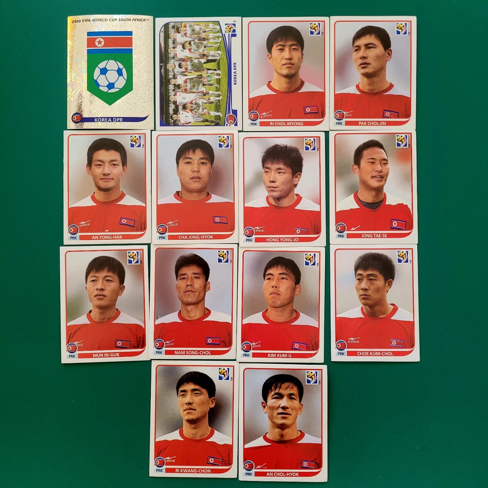
LINK to article - Italy World Cup Rewind: Humiliation at the Hands of North Korea, 1966 - bleacherreport.com/articles/1998811-italy-world-cup-rewin...
LINK to video - North Korea's 1966 World Cup Run | AFC Finners | Football History Documentary - www.youtube.com/watch?v=-J1o5CVldmU&t=332s
1. Im Shung-hwi (Korean: 임성휘; born 3 February 1946), also spelled Im Song Hwi, is a North Korean former football midfielder who played for the national team in the 1966 FIFA World Cup. He also played for February 8 Sports Club. Im was ultimately chosen as one of 22 players for the World Cup team. By that time, he had been capped for the national team a total of 12 times, according to the Evening Telegraph, although the Sunday Mirror reported it to be 18 caps. At the World Cup, the North Korean team played their home games at Ayresome Park in Middlesbrough, England, as part of Group 4 in the tournament which included the Soviet Union, Chile and Italy. Im was considered one of the team's top players in the midfield, and The Guardian described the team's playing style as "basically 4-2-4, with Pak Seung Zin, who must have one of the hardest shots of any of the World Cup finalists, and Im Seung Hwi feeding the wings and creating openings down the middle for Pak Doo Ik." The North Koreans, projected as having little chance of success, lost their first match, 3–0 against the Soviet Union, before tying Chile 1–1. After Chile, the team then played against heavily-favored Italy to determine the qualifier to the next round. In a massive upset, North Korea won 1–0 on a goal by Pak Doo-ik. Im recorded an assist on Pak's goal, having headed the ball to him before he made the winning shot. The team eventually lost 5–3 in the quarterfinals to Portugal; the North Koreans had opened the scoring with a goal by Pak Seung-zin in the first minute, with Im having made the assist. Im ended the World Cup having appeared in all four matches, playing all 360 minutes.
-----------------------------------------------------------------------------------
2. Yang Song-guk (Korean: 양성국; born 19 August 1944) is a North Korean football forward who played for North Korea in the 1966 FIFA World Cup. There he scored against Portugal in the Quarter-finals at Goodison Park. He also played for Kigwancha Pyongyang. He also competed in the men's tournament at the 1976 Summer Olympics.
---------------------------------------------------------------------------------
3. Rim Jung-son, also known as Lim Zoong-sun (림중선; born 16 July 1943). Rim Jung-son is a former centre or right back. He spent his entire career for Moranbong throughout the 1960s and 1970s. He was a member of North Korea national team from 1965 to 1974, participating to the 1966 FIFA World Cup.Considered one of the main defenders of the North Korea team, Rim Jung-son was focused in his defensive task and never left his own half during active play, doing so only during set pieces. He was pretty careful at defending but his timely response in the tackling was his best asset. He was seen tackling successfully the Soviet wingers to stop them from crossing or Chilean players like Prieto and Landa to stop them from reaching the goal. He wasn't a big guy and not notably fast but he wasn't light either and his decent short sprints helped him reach the ball in time for making a tackle. His mentality and will to fight were also strong points. Sporadically in charge of taking free kicks, he delivered a powerful shot that finished over the crossbar against Soviet Union and a pinpoint cross against Chile that was cleared but followed by Pak Sung-jin's goal. Against USSR, in one of the rare occasions he was seen forward, he send a dangerous right-footed cross in the box with an acrobatic volley. Used as centre back in the first two World Cup group matches, he was instead deployed as right back against Italy and Portugal.
------------------------------------------------------------------------------------------
4. Pak Seung-zin (a.k.a. Pak Sung / 박승진 Jin; 11 January 1941 – 5 August 2011) was a North Korean footballer. He represented North Korea at the 1966 FIFA World Cup in England, scoring two goals, against Chile and Portugal. He was the first Asian footballer to score a goal in the World Cup. Career - In his book, The Aquariums of Pyongyang, North Korean defector Kang Chol-hwan claimed that he met Pak in the Yodok concentration camp. He says that Pak and other players on the 1966 team were imprisoned for celebrating the team's victory over Italy in a bar, which was seen as "a sign of bourgeois decadence" by North Korean officials. According to Kang, Pak was in the camp for over 20 years. However, in the documentary film The Game of Their Lives, Pak and the other players were interviewed and denied there had been any retribution.
---------------------------------------------------------------------------------------
5. Han Bong-zin (Korean: 한봉진; born 2 September 1945), also called Han Bong Jin, is a North Korean former football outside forward who played for the national team in the 1966 FIFA World Cup. He also played for 2.8 Sports Team. He later served as the manager of the national team from 1980 to 1981. International career - In 1957, the North Korea national football team was re-organized with the goal of competing at the 1966 FIFA World Cup. In c. 1962, Han was chosen as one of the best 40 players from the North Korean leagues, whose membership reportedly consisted of over 250,000, to be considered for the national team. The 40 players were enlisted into the Army as military officers, under the leadership of colonel and coach Myung Rye-hyun, and went under strict training for the next four years in preparation for the cup. Han and the others trained twice a day starting at 6:00 a.m. and were under other restrictions which included being unmarried, no smoking, no drinking, and (for the last six months) being in bed by 10:00 p.m. Han, an outside right, was ultimately chosen as one of 22 players for the World Cup team. He was the most experienced player on the squad and had a cap total listed by varying sources as 49, 52, or 72 by the time of the competition. Han was considered the best member of the North Korean team and received comparisons to Garrincha for his dribbling and Bobby Charlton for his shooting. The radio station in Pyongyang alleged that he "overshadows the world-renowned Brazilian player" – Pelé. The Evening Telegraph mentioned him as being one of the top two stars of the team and noted that he "demoralised countless defences with his speed and skill, and he is a powerful two-footed kicker.
--------------------------------------------------------------------------------------
6. Pak Doo-ik (Chosungul: 박두익; Hanja: 朴斗翼; born 17 December 1936) is a North Korean former footballer who played as a forward. He scored the goal which knocked out Italy from the group stage of the 1966 FIFA World Cup. Pak Doo-ik was born in Pyongyang. He represented North Korea at the 1966 FIFA World Cup in England, scoring the winning goal in their 1–0 win over Italy at Ayresome Park, Middlesbrough, a game since documented in the film The Game of Their Lives by British filmmaker Daniel Gordon. The result is still considered one of the World Cup's biggest ever upsets, with Italy – holders of a then joint-record two world titles – having been widely expected to face no difficulty in comfortably beating North Korea, who were making their tournament debut. Drawn in a group with Italy, Chile and the USSR, the North Koreans were based in the north-eastern English industrial town of Middlesbrough during the tournament, playing their matches at Ayresome Park stadium. After a 0–3 defeat against the USSR, their courageous and spirited display in an exciting 1–1 draw against Chile won the hearts of the local people. Their surprising win against the powerful Italians further cemented their popularity in the town. Pak, speaking in 2002 on a return to Middlesbrough with the surviving members of the 1966 North Korea team, recalled that "It was the day I learnt football is not all about winning. I learnt that playing football can improve diplomatic relations and promote peace." After the victory, Pak, who was, at the time, a corporal in the North Korean army, was promoted to sergeant. An original ticket to the match is on display among other historical football items at the FIFA World Football Museum in Zurich.