View allAll Photos Tagged Develop,
05/05/2023. London, United Kingdom. Sophie, Duchess of Edinburgh, Prince Edward, Duke of Edinburgh and The Foreign Secretary James Cleverly at the Small Island Developing States Coronation Event. Treasury. Picture by Kirsty O'Connor/Treasury
A lovely storm which developed inland of Darwin before moving across the southern end of the harbour.
A full container vessel operated by the Evergreen Line sails under the Golden Gate Bridge, near Fort Point, in San Francisco Bay, California. Evergreen operates the fourth largest container fleet in the world with over 150 ships.
This particular vessel is the "Ever Develop". There are two 'Develop's' in the Evergreen fleet, 'Develop 1' and 'Develop 2'. I could not determine which of the two is pictured in this photo. This is a Panamanian-flagged vessel launched in 1998 with a maximum TEU capacity of 4211 tons. The ship was built by Mitsubishi Heavy Industries Ltd. in Shimonoseki, Japan and can carry up to 476 reefer containers.
Fort Point, at the bottom-right of this photograph, is located on the southern side of the Golden Gate at the entrance to San Francisco Bay. It was built just prior to the Civil War by the US Army Corps of Engineers in order to protect and defend the Bay against hostile warships. Today, it is a National Historic Site administered by the National Park Service.
If you look closely, you can just make out the diminutive 'Fort Point Lighthouse' on the roof of Fort Point. This is actually the third lighthouse to stand at this location. The first was built in 1853 and torn down a year later to make room for the fort. The second was built on a narrow ledge between the fort and the water in 1855 but strong tidal currents eventually undermined the shore and the lighthouse had to be removed. The tower was replaced with the third and final light placed in its present position atop the fort.
c/n 2350705
NATO codename:- Cookpot
Developed from the Tu-104, only 164 Tu-124 airliners were built. There were few orders as most customers were waiting for the rear engined Tu-134, which became a huge success. Despite this, the last military examples of the Tu-124 were retired in 1992.
Built in 1964, this Tu-124 came to Monino in 1981. The fuselage was badly damaged by fire in 2002, and so far only a temporary repair has been carried out. Only about six Tu-124s survive.
Central Air Force museum, Monino, Moscow Oblast, Russia.
27th August 2017
+++ DISCLAIMER +++
Nothing you see here is real, even though the conversion or the presented background story might be based on authentic facts. BEWARE!
Some background:
The English Electric Skyspark was a British fighter aircraft that served as an interceptor during the 1960s, the 1970s and into the late 1980s. It remains the only UK-designed-and-built fighter capable of Mach 2. The Skyspark was designed, developed, and manufactured by English Electric, which was later merged into the newly-formed British Aircraft Corporation. Later the type was marketed as the BAC Skyspark.
The specification for the aircraft followed the cancellation of the Air Ministry's 1942 E.24/43 supersonic research aircraft specification which had resulted in the Miles M.52 program. W.E.W. "Teddy" Petter, formerly chief designer at Westland Aircraft, was a keen early proponent of Britain's need to develop a supersonic fighter aircraft. In 1947, Petter approached the Ministry of Supply (MoS) with his proposal, and in response Specification ER.103 was issued for a single research aircraft, which was to be capable of flight at Mach 1.5 (1,593 km/h) and 50,000 ft (15,000 m).
Petter initiated a design proposal with F W "Freddie" Page leading the design and Ray Creasey responsible for the aerodynamics. As it was designed for Mach 1.5, it had a 40° swept wing to keep the leading edge clear of the Mach cone. To mount enough power into the airframe, two engines were installed, in an unusual, stacked layout and with a high tailplane This proposal was submitted in November 1948, and in January 1949 the project was designated P.1 by English Electric. On 29 March 1949 MoS granted approval to start the detailed design, develop wind tunnel models and build a full-size mock-up.
The design that had developed during 1948 evolved further during 1949 to further improve performance. To achieve Mach 2 the wing sweep was increased to 60° with the ailerons moved to the wingtips. In late 1949, low-speed wind tunnel tests showed that a vortex was generated by the wing which caused a large downwash on the initial high tailplane; this issue was solved by lowering the tail below the wing. Following the resignation of Petter, Page took over as design team leader for the P.1. In 1949, the Ministry of Supply had issued Specification F23/49, which expanded upon the scope of ER103 to include fighter-level manoeuvring. On 1 April 1950, English Electric received a contract for two flying airframes, as well as one static airframe, designated P.1.
The Royal Aircraft Establishment disagreed with Petter's choice of sweep angle (60 degrees) and the stacked engine layout, as well as the low tailplane position, was considered to be dangerous, too. To assess the effects of wing sweep and tailplane position on the stability and control of Petter's design Short Brothers were issued a contract, by the Ministry of Supply, to produce the Short SB.5 in mid-1950. This was a low-speed research aircraft that could test sweep angles from 50 to 69 degrees and tailplane positions high or low. Testing with the wings and tail set to the P.1 configuration started in January 1954 and confirmed this combination as the correct one. The proposed 60-degree wing sweep was retained, but the stacked engines had to give way to a more conventional configuration with two engines placed side-by-side in the tail, but still breathing through a mutual nose air intake.
From 1953 onward, the first three prototype aircraft were hand-built at Samlesbury. These aircraft had been assigned the aircraft serials WG760, WG763, and WG765 (the structural test airframe). The prototypes were powered by un-reheated Armstrong Siddeley Sapphire turbojets, as the selected Rolls-Royce Avon engines had fallen behind schedule due to their own development problems. Since there was not much space in the fuselage for fuel, the thin wings became the primary fuel tanks and since they also provided space for the stowed main undercarriage the fuel capacity was relatively small, giving the prototypes an extremely limited endurance. The narrow tires housed in the thin wings rapidly wore out if there was any crosswind component during take-off or landing. Outwardly, the prototypes looked very much like the production series, but they were distinguished by the rounded-triangular air intake with no center-body at the nose, short fin, and lack of operational equipment.
On 9 June 1952, it was decided that there would be a second phase of prototypes built to develop the aircraft toward achieving Mach 2.0 (2,450 km/h); these were designated P.1B while the initial three prototypes were retroactively reclassified as P.1A. P.1B was a significant improvement on P.1A. While it was similar in aerodynamics, structure and control systems, it incorporated extensive alterations to the forward fuselage, reheated Rolls Royce Avon R24R engines, a conical center body inlet cone, variable nozzle reheat and provision for weapons systems integrated with the ADC and AI.23 radar. Three P.1B prototypes were built, assigned serials XA847, XA853 and XA856.
In May 1954, WG760 and its support equipment were moved to RAF Boscombe Down for pre-flight ground taxi trials; on the morning of 4 August 1954, WG760 flew for the first time from Boscombe Down. One week later, WG760 officially achieved supersonic flight for the first time, having exceeded the speed of sound during its third flight. While WG760 had proven the P.1 design to be viable, it was plagued by directional stability problems and a dismal performance: Transonic drag was much higher than expected, and the aircraft was limited to Mach 0.98 (i.e. subsonic), with a ceiling of just 48,000 ft (14,630 m), far below the requirements.
To solve the problem and save the P.1, Petter embarked on a major redesign, incorporating the recently discovered area rule, while at the same time simplifying production and maintenance. The redesign entailed a new, narrower canopy, a revised air intake, a pair of stabilizing fins under the rear fuselage, and a shallow ventral fairing at the wings’ trailing edge that not only reduced the drag coefficient along the wing/fuselage intersection, it also provided space for additional fuel.
On 4 April 1957 the modified P.1B (XA847) made the first flight, immediately exceeding Mach 1. During the early flight trials of the P.1B, speeds in excess of 1,000 mph were achieved daily.
In late October 1958, the plane was officially presented. The event was celebrated in traditional style in a hangar at Royal Aircraft Establishment (RAE) Farnborough, with the prototype XA847 having the name ‘Skyspark’ freshly painted on the nose in front of the RAF Roundel, which almost covered it. A bottle of champagne was put beside the nose on a special rig which allowed the bottle to safely be smashed against the side of the aircraft.
On 25 November 1958 the P.1B XA847 reached Mach 2 for the first time. This made it the second Western European aircraft to reach Mach 2, the first one being the French Dassault Mirage III just over a month earlier on 24 October 1958
The first operational Skyspark, designated Skyspark F.1, was designed as a pure interceptor to defend the V Force airfields in conjunction with the "last ditch" Bristol Bloodhound missiles located either at the bomber airfield, e.g. at RAF Marham, or at dedicated missile sites near to the airfield, e.g. at RAF Woodhall Spa near the Vulcan station RAF Coningsby. The bomber airfields, along with the dispersal airfields, would be the highest priority targets in the UK for enemy nuclear weapons. To best perform this intercept mission, emphasis was placed on rate-of-climb, acceleration, and speed, rather than range – originally a radius of operation of only 150 miles (240 km) from the V bomber airfields was specified – and endurance. Armament consisted of a pair of 30 mm ADEN cannon in front of the cockpit, and two pylons for IR-guided de Havilland Firestreak air-to-air missiles were added to the lower fuselage flanks. These hardpoints could, alternatively, carry pods with unguided 55 mm air-to-air rockets. The Ferranti AI.23 onboard radar provided missile guidance and ranging, as well as search and track functions.
The next two Skyspark variants, the Skyspark F.1A and F.2, incorporated relatively minor design changes, but for the next variant, the Skyspark F.3, they were more extensive: The F.3 had higher thrust Rolls-Royce Avon 301R engines, a larger squared-off fin that improved directional stability at high speed further and a strengthened inlet cone allowing a service clearance to Mach 2.0 (2,450 km/h; the F.1, F.1A and F.2 were all limited to Mach 1.7 (2,083 km/h). An upgraded A.I.23B radar and new, radar-guided Red Top missiles offered a forward hemisphere attack capability, even though additional electronics meant that the ADEN guns had to be deleted – but they were not popular in their position in front of the windscreen, because the muzzle flash blinded the pilot upon firing. The new engines and fin made the F.3 the highest performance Skyspark yet, but this came at a steep price: higher fuel consumption, resulting in even shorter range. From this basis, a conversion trainer with a side-by-side cockpit, the T.4, was created.
The next interceptor variant was already in development, but there was a need for an interim solution to partially address the F.3's shortcomings, the F.3A. The F.3A introduced two major improvements: a larger, non-jettisonable, 610-imperial-gallon (2,800 L) ventral fuel tank, resulting in a much deeper and longer belly fairing, and a new, kinked, conically cambered wing leading edge. The conically cambered wing improved manoeuvrability, especially at higher altitudes, and it offered space for a slightly larger leading edge fuel tank, raising the total usable internal fuel by 716 imperial gallons (3,260 L). The enlarged ventral tank not only nearly doubled available fuel, it also provided space at its front end for a re-instated pair of 30 mm ADEN cannon with 120 RPG. Alternatively, a retractable pack with unguided 55 mm air-to-air rockets could be installed, or a set of cameras for reconnaissance missions. The F.3A also introduced an improved A.I.23B radar and the new IR-guided Red Top missile, which was much faster and had greater range and manoeuvrability than the Firestreak. Its improved infrared seeker enabled a wider range of engagement angles and offered a forward hemisphere attack capability that would allow the Skyspark to attack even faster bombers (like the new, supersonic Tupolev T-22 Blinder) through a collision-course approach.
Wings and the new belly tank were also immediately incorporated in a second trainer variant, the T.5.
The ultimate variant, the Skyspark F.6, was nearly identical to the F.3A, with the exception that it could carry two additional 260-imperial-gallon (1,200 L) ferry tanks on pylons over the wings. These tanks were jettisonable in an emergency and gave the F.6 a substantially improved deployment capability, even though their supersonic drag was so high that the extra fuel would only marginally raise the aircraft’s range when flying beyond the sound barrier for extended periods.
Finally, there was the Skyspark F.2A; it was an early production F.2 upgraded with the new cambered wing, the squared fin, and the 610 imperial gallons (2,800 L) ventral tank. However, the F.2A retained the old AI.23 radar, the IR-guided Firestreak missile and the earlier Avon 211R engines. Although the F.2A lacked the thrust of the later Skysparks, it had the longest tactical range of all variants, and was used for low-altitude interception over West Germany.
The first Skysparks to enter service with the RAF, three pre-production P.1Bs, arrived at RAF Coltishall in Norfolk on 23 December 1959, joining the Air Fighting Development Squadron (AFDS) of the Central Fighter Establishment, where they were used to clear the Skyspark for entry into service. The production Skyspark F.1 entered service with the AFDS in May 1960, allowing the unit to take part in the air defence exercise "Yeoman" later that month. The Skyspark F.1 entered frontline squadron service with 74 Squadron at Coltishall from 11 July 1960. This made the Skyspark the second Western European-built combat aircraft with true supersonic capability to enter service and the second fully supersonic aircraft to be deployed in Western Europe (the first one in both categories being the Swedish Saab 35 Draken on 8 March 1960 four months earlier).
The aircraft's radar and missiles proved to be effective, and pilots reported that the Skyspark was easy to fly. However, in the first few months of operation the aircraft's serviceability was extremely poor. This was due to the complexity of the aircraft systems and shortages of spares and ground support equipment. Even when the Skyspark was not grounded by technical faults, the RAF initially struggled to get more than 20 flying hours per aircraft per month compared with the 40 flying hours that English Electric believed could be achieved with proper support. In spite of these concerns, within six months of the Skyspark entering service, 74 Squadron was able to achieve 100 flying hours per aircraft.
Deliveries of the slightly improved Skyspark F.1A, with revised avionics and provision for an air-to-air refueling probe, allowed two more squadrons, 56 and 111 Squadron, both based at RAF Wattisham, to convert to the Skyspark in 1960–1961. The Skyspark F.1 was only ordered in limited numbers and served only for a short time; nonetheless, it was viewed as a significant step forward in Britain's air defence capabilities. Following their replacement from frontline duties by the introduction of successively improved Skyspark variants, the remaining F.1 aircraft were employed by the Skyspark Conversion Squadron.
The improved F.2 entered service with 19 Squadron at the end of 1962 and 92 Squadron in early 1963. Conversion of these two squadrons was aided by the of the two-seat T.4 and T.5 trainers (based on the F.3 and F.3A/F.6 fighters), which entered service with the Skyspark Conversion Squadron (later renamed 226 Operational Conversion Unit) in June 1962. While the OCU was the major user of the two-seater, small numbers were also allocated to the front-line fighter squadrons. More F.2s were produced than there were available squadron slots, so later production aircraft were stored for years before being used operationally; some of these Skyspark F.2s were converted to F.2As.
The F.3, with more powerful engines and the new Red Top missile was expected to be the definitive Skyspark, and at one time it was planned to equip ten squadrons, with the remaining two squadrons retaining the F.2. However, the F.3 also had only a short operational life and was withdrawn from service early due to defence cutbacks and the introduction of the even more capable and longer-range F.6, some of which were converted F.3s.
The introduction of the F.3 and F.6 allowed the RAF to progressively reequip squadrons operating aircraft such as the subsonic Gloster Javelin and retire these types during the mid-1960s. During the 1960s, as strategic awareness increased and a multitude of alternative fighter designs were developed by Warsaw Pact and NATO members, the Skyspark's range and firepower shortcomings became increasingly apparent. The transfer of McDonnell Douglas F-4 Phantom IIs from Royal Navy service enabled these much longer-ranged aircraft to be added to the RAF's interceptor force, alongside those withdrawn from Germany as they were replaced by SEPECAT Jaguars in the ground attack role.
The Skyspark's direct replacement was the Tornado F.3, an interceptor variant of the Panavia Tornado. The Tornado featured several advantages over the Skyspark, including far larger weapons load and considerably more advanced avionics. Skysparks were slowly phased out of service between 1974 and 1988, even though they lasted longer than expected because the definitive Tornado F.3 went through serious teething troubles and its service introduction was delayed several times. In their final years, the Skysparks’ airframes required considerable maintenance to keep them airworthy due to the sheer number of accumulated flight hours.
General characteristics:
Crew: 1
Length: 51 ft 2 in (15,62 m) fuselage only
57 ft 3½ in (17,50 m) including pitot
Wingspan: 34 ft 10 in (10.62 m)
Height: 17 ft 6¾ in (5.36 m)
Wing area: 474.5 sq ft (44.08 m²)
Empty weight: 31,068 lb (14,092 kg) with armament and no fuel
Gross weight: 41,076 lb (18,632 kg) with two Red Tops, ammunition, and internal fuel
Max. takeoff weight: 45,750 lb (20,752 kg)
Powerplant:
2× Rolls-Royce Avon 301R afterburning turbojet engines,
12,690 lbf (56.4 kN) thrust each dry, 16,360 lbf (72.8 kN) with afterburner
Performance:
Maximum speed: Mach 2.27 (1,500 mph+ at 40,000 ft)
Range: 738 nmi (849 mi, 1,367 km)
Combat range: 135 nmi (155 mi, 250 km) supersonic intercept radius
Range: 800 nmi (920 mi, 1,500 km) with internal fuel
1,100 nmi (1,300 mi; 2,000 km) with external overwing tanks
Service ceiling: 60,000 ft (18,000 m)
Zoom ceiling: 70,000 ft (21,000 m)
Rate of climb: 20,000 ft/min (100 m/s) sustained to 30,000 ft (9,100 m)
Zoom climb: 50,000 ft/min
Time to altitude: 2.8 min to 36,000 ft (11,000 m)
Wing loading: 76 lb/sq ft (370 kg/m²) with two AIM-9 and 1/2 fuel
Thrust/weight: 0.78 (1.03 empty)
Armament:
2× 30 mm (1.181 in) ADEN cannon with 120 RPG in the lower fuselage
2× forward fuselage hardpoints for a single Firestreak or Red Top AAM each
2× overwing pylon stations for 2.000 lb (907 kg each)
for 260 imp gal (310 US gal; 1,200 l) ferry tanks
The kit and its assembly:
This build was a submission to the “Hunter, Lightning, Canberra” group build at whatifmodellers.com, and one of my personal ultimate challenges – a project that you think about very often, but the you put the thought back into its box when you realize that turning this idea into hardware will be a VERY tedious, complex and work-intensive task. But the thematic group build was the perfect occasion to eventually tackle the idea of a model of a “side-by-side engine BAC Lightning”, a.k.a. “Flatning”, as a rather conservative alternative to the real aircraft’s unique and unusual design with stacked engines in the fuselage, which brought a multitude of other design consequences that led to a really unique aircraft.
And it sound so simple: take a Lightning, just change the tail section. But it’s not that simple, because the whole fuselage shape would be different, resulting in less depth, the wings have to be attached somewhere and somehow, the landing gear might have to be adjusted/shortened, and how the fuselage diameter shape changes along the hull, so that you get a more or less smooth shape, was also totally uncertain!
Initially I considered a MiG Ye-152 as a body donor, but that was rejected due to the sheer price of the only available kit (ModelSvit). A Chinese Shenyang J-8I would also have been ideal – but there’s not 1:72 kit of this aircraft around, just of its successor with side intakes, a 1:72 J-8II from trumpeter.
I eventually decided to keep costs low, and I settled for the shaggy PM Model Su-15 (marketed as Su-21) “Flagon” as main body donor: it’s cheap, the engines have a good size for Avons and the pen nib fairing has a certain retro touch that goes well with the Lightning’s Fifties design.
The rest of this "Flatning" came from a Hasegawa 1:72 BAC Lightning F.6 (Revell re-boxing).
Massive modifications were necessary and lots of PSR. In an initial step the Flagon lost its lower wing halves, which are an integral part of the lower fuselage half. The cockpit section was cut away where the intake ducts begin. The Lightning had its belly tank removed (set aside for a potential later re-installation), and dry-fitting and crude measures suggested that only the cockpit section from the Lightning, its spine and the separate fin would make it onto the new fuselage.
Integrating the parts was tough, though! The problem that caused the biggest headaches: how to create a "smooth" fuselage from the Lightning's rounded front end with a single nose intake that originally develops into a narrow, vertical hull, combined with the boxy and rather wide Flagon fuselage with large Phantom-esque intakes? My solution: taking out deep wedges from all (rather massive) hull parts along the intake ducts, bend the leftover side walls inwards and glue them into place, so that the width becomes equal with the Lightning's cockpit section. VERY crude and massive body work!
However, the Lightning's cockpit section for the following hull with stacked engines is much deeper than the Flagon's side-by-side layout. My initial idea was to place the cockpit section higher, but I would have had to transplant a part of the Lightning's upper fuselage (with the spine on top, too!) onto the "flat" Flagon’s back. But this would have looked VERY weird, and I'd have had to bridge the round ventral shape of the Lightning into the boxy Flagon underside, too. This was no viable option, so that the cockpit section had to be further modified; I cut away the whole ventral cockpit section, at the height of the lower intake lip. Similar to my former Austrian Hasegawa Lightning, I also cut away the vertical bulkhead directly behind the intake opening - even though I did not improve the cockpit with a better tub with side consoles. At the back end, the Flagon's jet exhausts were opened and received afterburner dummies inside as a cosmetic upgrade.
Massive PSR work followed all around the hull. The now-open area under the cockpit was filled with lead beads to keep the front wheel down, and I implanted a landing gear well (IIRC, it's from an Xtrakit Swift). With the fuselage literally taking shape, the wings were glued together and the locator holes for the overwing tanks filled, because they would not be mounted.
To mount the wings to the new hull, crude measurements suggested that wedges had to be cut away from the Lightning's wing roots to match the weird fuselage shape. They were then glued to the shoulders, right behind the cockpit due to the reduced fuselage depth. At this stage, the Lightning’s stabilizer attachment points were transplanted, so that they end up in a similar low position on the rounded Su-15 tail. Again, lots of PSR…
At this stage I contemplated the next essential step: belly tank or not? The “Flatning” would have worked without it, but its profile would look rather un-Lightning-ish and rather “flat”. On the other side, a conformal tank would probably look quite strange on the new wide and flat ventral fuselage...? Only experiments could yield an answer, so I glued together the leftover belly bulge parts from the Hasegawa kit and played around with it. I considered a new, wider belly tank, but I guess that this would have looked too ugly. I eventually settled upon the narrow F.6 tank and also used the section behind it with the arrestor hook. I just reduced its depth by ~2 mm, with a slight slope towards the rear because I felt (righteously) that the higher wing position would lower the model’s stance. More massive PSR followed….
Due to the expected poor ground clearance, the Lightning’s stabilizing ventral fins were mounted directly under the fuselage edges rather than on the belly tank. Missile pylons for Red Tops were mounted to the lower front fuselage, similar to the real arrangement, and cable fairings, scratched from styrene profiles, were added to the lower flanks, stretching the hull optically and giving more structure to the hull.
To my surprise, I did not have to shorten the landing gear’s main legs! The wings ended up a little higher on the fuselage than on the original Lightning, and the front wheel sits a bit further back and deeper inside of its donor well, too, so that the fuselage comes probably 2 mm closer to the ground than an OOB Lightning model. Just like on the real aircraft, ground clearance is marginal, but when the main wheels were finally in place, the model turned out to have a low but proper stance, a little F8U-ish.
Painting and markings:
I was uncertain about the livery for a long time – I just had already settled upon an RAF aircraft. But the model would not receive a late low-viz scheme (the Levin, my mono-engine Lightning build already had one), and no NMF, either. I was torn between an RAF Germany all-green over NMF undersides livery, but eventually went for a pretty standard RAF livery in Dark Sea Grey/Dark Green over NMF undersides, with toned-down post-war roundels.
A factor that spoke in favor of this route was a complete set of markings for an RAF 11 Squadron Lightning F.6 in such a guise on an Xtradecal set, which also featured dayglo orange makings on fin, wings and stabilizers – quite unusual, and a nice contrast detail on the otherwise very conservative livery. All stencils were taken from the OOB Revell sheet for the Lightning. Just the tactical code “F” on the tail was procured elsewhere, it comes from a Matchbox BAC Lightning’s sheet.
After basic painting the model received the usual black ink washing, some post-panel-shading and also a light treatment with graphite to create soot strains around the jet exhausts and the gun ports, and to emphasize the raised panel lines on the Hasegawa parts.
Finally, the model was sealed with matt acrylic varnish and final bits and pieces like the landing gear and the Red Tops (taken OOB) were mounted.
A major effort, and I have seriously depleted my putty stocks for this build! However, the result looks less spectacular than it actually is: changing a Lightning from its literally original stacked engine layout into a more conservative side-by-side arrangement turned out to be possible, even though the outcome is not really pretty. But it works and is feasible!
Voronezh is a city and the administrative centre of Voronezh Oblast in southwestern Russia straddling the Voronezh River, located 12 kilometers (7.5 mi) from where it flows into the Don River. The city sits on the Southeastern Railway, which connects western Russia with the Urals and Siberia, the Caucasus and Ukraine, and the M4 highway (Moscow–Voronezh–Rostov-on-Don–Novorossiysk). In recent years the city has experienced rapid population growth, rising in 2021 to 1,057,681, up from 889,680 recorded in the 2010 Census, making it the 14th-most populous city in the country.
For many years, the hypothesis of the Soviet historian Vladimir Zagorovsky dominated: he produced the toponym "Voronezh" from the hypothetical Slavic personal name Voroneg. This man allegedly gave the name of a small town in the Chernigov Principality (now the village of Voronizh in Ukraine). Later, in the 11th or 12th century, the settlers were able to "transfer" this name to the Don region, where they named the second city Voronezh, and the river got its name from the city. However, now many researchers criticize the hypothesis, since in reality neither the name of Voroneg nor the second city was revealed, and usually the names of Russian cities repeated the names of the rivers, but not vice versa.
A comprehensive scientific analysis was conducted in 2015–2016 by the historian Pavel Popov. His conclusion: "Voronezh" is a probable Slavic macrotoponym associated with outstanding signs of nature, has a root voron- (from the proto-Slavic vorn) in the meaning of "black, dark" and the suffix -ezh (-azh, -ozh). It was not “transferred” and in the 8th - 9th centuries it marked a vast territory covered with black forests (oak forests) - from the mouth of the Voronezh river to the Voronozhsky annalistic forests in the middle and upper reaches of the river, and in the west to the Don (many forests were cut down). The historian believes that the main "city" of the early town-planning complex could repeat the name of the region – Voronezh. Now the hillfort is located in the administrative part of the modern city, in the Voronezh upland oak forest. This is one of Europe's largest ancient Slavic hillforts, the area of which – more than 9 hectares – 13 times the area of the main settlement in Kyiv before the baptism of Rus.
In it is assumed that the word "Voronezh" means bluing - a technique to increase the corrosion resistance of iron products. This explanation fits well with the proximity to the ancient city of Voronezh of a large iron deposit and the city of Stary Oskol. As well as the name of Voroneț Monastery known for its blue shade.
Folk etymology claims the name comes from combining the Russian words for raven (ворон) and hedgehog (еж) into Воронеж. According to this explanation two Slavic tribes named after the animals used this combination to name the river which later in turn provided the name for a settlement. There is not believed to be any scientific support for this explanation.
In the 16th century, the Middle Don basin, including the Voronezh river, was gradually conquered by Muscovy from the Nogai Horde (a successor state of the Golden Horde), and the current city of Voronezh was established in 1585 by Feodor I as a fort protecting the Muravsky Trail trade route against the slave raids of the Nogai and Crimean Tatars. The city was named after the river.
17th to 19th centuries
In the 17th century, Voronezh gradually evolved into a sizable town. Weronecz is shown on the Worona river in Resania in Joan Blaeu's map of 1645. Peter the Great built a dockyard in Voronezh where the Azov Flotilla was constructed for the Azov campaigns in 1695 and 1696. This fleet, the first ever built in Russia, included the first Russian ship of the line, Goto Predestinatsia. The Orthodox diocese of Voronezh was instituted in 1682 and its first bishop, Mitrofan of Voronezh, was later proclaimed the town's patron saint.
Owing to the Voronezh Admiralty Wharf, for a short time, Voronezh became the largest city of South Russia and the economic center of a large and fertile region. In 1711, it was made the seat of the Azov Governorate, which eventually morphed into the Voronezh Governorate.
In the 19th century, Voronezh was a center of the Central Black Earth Region. Manufacturing industry (mills, tallow-melting, butter-making, soap, leather, and other works) as well as bread, cattle, suet, and the hair trade developed in the town. A railway connected Voronezh with Moscow in 1868 and Rostov-on-Don in 1871.
Designer: Wang Dexing (王德兴)
1975, June
Develop the spirit to wage bitter struggle
Fayang jianku fendou jingshen (发扬艰苦奋斗精神)
Call nr.: BG E13/811 (Landsberger collection)
More? See: chineseposters.net/themes/seven-may-cadre-schools
Photo Copyright 2012, dynamo.photography.
All rights reserved, no use without license
From Wikipedia, the free encyclopedia
(Redirected from Hong kong)
Hong Kong, officially the Hong Kong Special Administrative Region of the People's Republic of China, is an autonomous territory south to Mainland China and east to Macao in East Asia. With around 7.2 million Hong Kongers of various nationalities[note 2] in a territory of 1,104 km2, Hong Kong is the world's fourth most densely populated country or territory.
Hong Kong used to be a British colony with the perpetual cession of Hong Kong Island from the Qing Empire after the First Opium War (1839–42). The colony expanded to the Kowloon Peninsula in 1860 and acquired a 99-year lease of the New Territories from 1898. Hong Kong was later occupied by Japan during the Second World War until British control resumed in 1945. The Sino-British Joint Declaration signed between the United Kingdom and China in 1984 paved way for the transfer of sovereignty of Hong Kong in 1997, when it became a special administrative region (SAR) of the People's Republic of China with a high degree of autonomy.[15]
Under the principle of "one country, two systems",[16][17] Hong Kong maintains a separate political and economic system from China. Except in military defence and foreign affairs, Hong Kong maintains its independent executive, legislative and judiciary powers.[18] In addition, Hong Kong develops relations directly with foreign states and international organisations in a broad range of "appropriate fields".[19] Hong Kong involves in international organizations, such as the WTO[20] and the APEC [21], actively and independently.
Hong Kong is one of the world's most significant financial centres, with the highest Financial Development Index score and consistently ranks as the world's most competitive and freest economic entity.[22][23] As the world's 8th largest trading entity,[24] its legal tender, the Hong Kong dollar, is the world's 13th most traded currency.[25] As the world's most visited city,[26][27] Hong Kong's tertiary sector dominated economy is characterised by competitive simple taxation and supported by its independent judiciary system.[28] Even with one of the highest per capita incomes in the world, it suffers from severe income inequality.[29]
Nicknamed "Pearl of the Orient", Hong Kong is renowned for its deep natural harbour, which boasts the world's fifth busiest port with ready access by cargo ships, and its impressive skyline, with the most skyscrapers in the world.[30][31] It has a very high Human Development Index ranking and the world's longest life expectancy.[32][33] Over 90% of the population makes use of well-developed public transportation.[34][35] Seasonal air pollution with origins from neighbouring industrial areas of Mainland China, which adopts loose emissions standards, has resulted in a high level of atmospheric particulates in winter.[36][37][38]
Contents
1 Etymology
2 History
2.1 Prehistory
2.2 Imperial China
2.3 British Crown Colony: 1842–1941
2.4 Japanese occupation: 1941–45
2.5 Resumption of British rule and industrialisation: 1945–97
2.6 Handover and Special Administrative Region status
3 Governance
3.1 Structure of government
3.2 Electoral and political reforms
3.3 Legal system and judiciary
3.4 Foreign relations
3.5 Human rights
3.6 Regions and districts
3.7 Military
4 Geography and climate
5 Economy
5.1 Financial centre
5.2 International trading
5.3 Tourism and expatriation
5.4 Policy
5.5 Infrastructure
6 Demographics
6.1 Languages
6.2 Religion
6.3 Personal income
6.4 Education
6.5 Health
7 Culture
7.1 Sports
7.2 Architecture
7.3 Cityscape
7.4 Symbols
8 See also
9 Notes
10 References
10.1 Citations
10.2 Sources
11 Further reading
12 External links
Etymology
Hong Kong was officially recorded in the 1842 Treaty of Nanking to encompass the entirety of the island.[39]
The source of the romanised name "Hong Kong" is not known, but it is generally believed to be an early imprecise phonetic rendering of the pronunciation in spoken Cantonese 香港 (Cantonese Yale: Hēung Góng), which means "Fragrant Harbour" or "Incense Harbour".[13][14][40] Before 1842, the name referred to a small inlet—now Aberdeen Harbour (Chinese: 香港仔; Cantonese Yale: Hēunggóng jái), literally means "Little Hong Kong"—between Aberdeen Island and the southern coast of Hong Kong Island. Aberdeen was an initial point of contact between British sailors and local fishermen.[41]
Another theory is that the name would have been taken from Hong Kong's early inhabitants, the Tankas (水上人); it is equally probable that romanisation was done with a faithful execution of their speeches, i.e. hōng, not hēung in Cantonese.[42] Detailed and accurate romanisation systems for Cantonese were available and in use at the time.[43]
Fragrance may refer to the sweet taste of the harbour's fresh water estuarine influx of the Pearl River or to the incense from factories lining the coast of northern Kowloon. The incense was stored near Aberdeen Harbour for export before Hong Kong developed Victoria Harbour.[40]
The name had often been written as the single word Hongkong until the government adopted the current form in 1926.[44] Nevertheless, a number of century-old institutions still retain the single-word form, such as the Hongkong Post, Hongkong Electric and the Hongkong and Shanghai Banking Corporation.
As of 1997, its official name is the "Hong Kong Special Administrative Region of the People's Republic of China". This is the official title as mentioned in the Hong Kong Basic Law and the Hong Kong Government's website;[45] however, "Hong Kong Special Administrative Region" and "Hong Kong" are widely accepted.
Hong Kong has carried many nicknames. The most famous among those is the "Pearl of the Orient", which reflected the impressive nightscape of the city's light decorations on the skyscrapers along both sides of the Victoria Harbour. The territory is also known as "Asia's World City".
History
Main articles: History of Hong Kong and History of China
Prehistory
Main article: Prehistoric Hong Kong
Archaeological studies support human presence in the Chek Lap Kok area (now Hong Kong International Airport) from 35,000 to 39,000 years ago and on Sai Kung Peninsula from 6,000 years ago.[46][47][48]
Wong Tei Tung and Three Fathoms Cove are the earliest sites of human habitation in Hong Kong during the Paleolithic Period. It is believed that the Three Fathom Cove was a river-valley settlement and Wong Tei Tung was a lithic manufacturing site. Excavated Neolithic artefacts suggested cultural differences from the Longshan culture of northern China and settlement by the Che people, prior to the migration of the Baiyue to Hong Kong.[49][50] Eight petroglyphs, which dated to the Shang Dynasty (c. 1600 BC – 1066 BC) in China, were discovered on the surrounding islands.[51]
Imperial China
Main article: History of Hong Kong under Imperial China
In 214 BC, Qin Shi Huang, the first emperor of a centralised China, conquered the Baiyue tribes in Jiaozhi (modern-day Liangguang region and Vietnam) and incorporated the area of Hong Kong into his imperial China for the first time. Hong Kong proper was assigned to the Nanhai commandery (modern-day Nanhai District), near the commandery's capital city Panyu.[52][53][54]
After a brief period of centralisation and collapse of the Qin dynasty, the area of Hong Kong was consolidated under the Kingdom of Nanyue, founded by general Zhao Tuo in 204 BC.[55] When Nanyue lost the Han-Nanyue War in 111 BC, Hong Kong came under the Jiaozhi commandery of the Han dynasty. Archaeological evidence indicates an increase of population and flourish of salt production. The Lei Cheng Uk Han Tomb on the Kowloon Peninsula is believed to have been built as a burial site during the Han dynasty.[56]
From the Han dynasty to the early Tang dynasty, Hong Kong was a part of Bao'an County. In the Tang dynasty, modern-day Guangzhou (Canton) flourished as an international trading centre. In 736, the Emperor Xuanzong of Tang established a military stronghold in Tuen Mun to strengthen defence of the coastal area.[57] The nearby Lantau Island was a salt production centre and salt smuggler riots occasionally broke out against the government. In c. 1075, The first village school, Li Ying College, was established around 1075 AD in modern-day New Territories by the Northern Song dynasty.[58] During their war against the Mongols, the imperial court of Southern Song was briefly stationed at modern-day Kowloon City (the Sung Wong Toi site) before their ultimate defeat by the Mongols at the Battle of Yamen in 1279.[59] The Mongols then established their dynastic court and governed Hong Kong for 97 years.
From the mid-Tang dynasty to the early Ming dynasty (1368–1644), Hong Kong was a part of Dongguan County. During the Ming dynasty, the area was transferred to Xin'an County. The indigenous inhabitants at that time consisted of several ethnicities such as Punti, Hakka, Tanka and Hoklo.
European discovery
The earliest European visitor on record was Jorge Álvares, a Portuguese explorer, who arrived in 1513.[60][61] Having established a trading post in a site they called "Tamão" in Hong Kong waters, Portuguese merchants commenced with regular trading in southern China. Subsequent military clashes between China and Portugal, however, led to the expulsion of all Portuguese merchants from southern China.
Since the 14th century, the Ming court had enforced the maritime prohibition laws that strictly forbade all private maritime activities in order to prevent contact with foreigners by sea.[62] When the Manchu Qing dynasty took over China, Hong Kong was directly affected by the Great Clearance decree of the Kangxi Emperor, who ordered the evacuation of coastal areas of Guangdong from 1661 to 1669. Over 16,000 inhabitants of Xin'an County including those in Hong Kong were forced to migrate inland; only 1,648 of those who had evacuated subsequently returned.[63][64]
British Crown Colony: 1842–1941
A painter at work. John Thomson. Hong Kong, 1871. The Wellcome Collection, London
Main articles: British Hong Kong and History of Hong Kong (1800s–1930s)
In 1839, threats by the imperial court of Qing to sanction opium imports caused diplomatic friction with the British Empire. Tensions escalated into the First Opium War. The Qing admitted defeat when British forces captured Hong Kong Island on 20 January 1841. The island was initially ceded under the Convention of Chuenpi as part of a ceasefire agreement between Captain Charles Elliot and Governor Qishan. A dispute between high-ranking officials of both countries, however, led to the failure of the treaty's ratification. On 29 August 1842, Hong Kong Island was formally ceded in perpetuity to the United Kingdom of Great Britain and Ireland under the Treaty of Nanking.[65] The British officially established a Crown colony and founded the City of Victoria in the following year.[66]
The population of Hong Kong Island was 7,450 when the Union Flag raised over Possession Point on 26 January 1841. It mostly consisted of Tanka fishermen and Hakka charcoal burners, whose settlements scattered along several coastal hamlets. In the 1850s, a large number of Chinese immigrants crossed the then-free border to escape from the Taiping Rebellion. Other natural disasters, such as flooding, typhoons and famine in mainland China would play a role in establishing Hong Kong as a place for safe shelter.[67][68]
Further conflicts over the opium trade between Britain and Qing quickly escalated into the Second Opium War. Following the Anglo-French victory, the Crown Colony was expanded to include Kowloon Peninsula (south of Boundary Street) and Stonecutter's Island, both of which were ceded to the British in perpetuity under the Convention of Beijing in 1860.
In 1898, Britain obtained a 99-year lease from Qing under the Convention for the Extension of Hong Kong Territory, in which Hong Kong obtained a 99-year lease of Lantau Island, the area north of Boundary Street in Kowloon up to Shenzhen River and over 200 other outlying islands.[69][70][71]
Hong Kong soon became a major entrepôt thanks to its free port status, attracting new immigrants to settle from both China and Europe. The society, however, remained racially segregated and polarised under early British colonial policies. Despite the rise of a British-educated Chinese upper-class by the late-19th century, race laws such as the Peak Reservation Ordinance prevented ethnic Chinese in Hong Kong from acquiring houses in reserved areas such as Victoria Peak. At this time, the majority of the Chinese population in Hong Kong had no political representation in the British colonial government. The British governors did rely, however, on a small number of Chinese elites, including Sir Kai Ho and Robert Hotung, who served as ambassadors and mediators between the government and local population.
File:1937 Hong Kong VP8.webmPlay media
Hong Kong filmed in 1937
In 1904, the United Kingdom established the world's first border and immigration control; all residents of Hong Kong were given citizenship as Citizens of United Kingdom and Colonies (CUKC).
Hong Kong continued to experience modest growth during the first half of the 20th century. The University of Hong Kong was established in 1911 as the territory's first higher education institute. While there had been an exodus of 60,000 residents for fear of a German attack on the British colony during the First World War, Hong Kong remained unscathed. Its population increased from 530,000 in 1916 to 725,000 in 1925 and reached 1.6 million by 1941.[72]
In 1925, Cecil Clementi became the 17th Governor of Hong Kong. Fluent in Cantonese and without a need for translator, Clementi introduced the first ethnic Chinese, Shouson Chow, into the Executive Council as an unofficial member. Under Clementi's tenure, Kai Tak Airport entered operation as RAF Kai Tak and several aviation clubs. In 1937, the Second Sino-Japanese War broke out when the Japanese Empire expanded its territories from northeastern China into the mainland proper. To safeguard Hong Kong as a freeport, Governor Geoffry Northcote declared the Crown Colony as a neutral zone.
Japanese occupation: 1941–45
Main article: Japanese occupation of Hong Kong
The Cenotaph in Hong Kong commemorates those who died in service in the First World War and the Second World War.[73]
As part of its military campaign in Southeast Asia during Second World War, the Japanese army moved south from Guangzhou of mainland China and attacked Hong Kong in on 8 December 1941.[74] Crossing the border at Shenzhen River on 8 December, the Battle of Hong Kong lasted for 18 days when British and Canadian forces held onto Hong Kong Island. Unable to defend against intensifying Japanese air and land bombardments, they eventually surrendered control of Hong Kong on 25 December 1941. The Governor of Hong Kong was captured and taken as a prisoner of war. This day is regarded by the locals as "Black Christmas".[75]
During the Japanese occupation of Hong Kong, the Japanese army committed atrocities against civilians and POWs, such as the St. Stephen's College massacre. Local residents also suffered widespread food shortages, limited rationing and hyper-inflation arising from the forced exchange of currency from Hong Kong dollars to Japanese military banknotes. The initial ratio of 2:1 was gradually devalued to 4:1 and ownership of Hong Kong dollars was declared illegal and punishable by harsh torture. Due to starvation and forced deportation for slave labour to mainland China, the population of Hong Kong had dwindled from 1.6 million in 1941 to 600,000 in 1945, when the United Kingdom resumed control of the colony on 2 September 1945.[76]
Resumption of British rule and industrialisation: 1945–97
Main articles: British Hong Kong, 1950s in Hong Kong, 1960s in Hong Kong, 1970s in Hong Kong, 1980s in Hong Kong, and 1990s in Hong Kong
Flag of British Hong Kong from 1959 to 1997
Hong Kong's population recovered quickly after the war, as a wave of skilled migrants from the Republic of China moved in to seek refuge from the Chinese Civil War. When the Communist Party eventually took full control of mainland China in 1949, even more skilled migrants fled across the open border for fear of persecution.[69] Many newcomers, especially those who had been based in the major port cities of Shanghai and Guangzhou, established corporations and small- to medium-sized businesses and shifted their base operations to British Hong Kong.[69] The establishment of a socialist state in China (People's Republic of China) on 1 October 1949 caused the British colonial government to reconsider Hong Kong's open border to mainland China. In 1951, a boundary zone was demarked as a buffer zone against potential military attacks from communist China. Border posts along the north of Hong Kong began operation in 1953 to regulate the movement of people and goods into and out of the territory.
Stamp with portrait of Queen Elizabeth II, 1953
In the 1950s, Hong Kong became the first of the Four Asian Tiger economies under rapid industrialisation driven by textile exports, manufacturing industries and re-exports of goods to China. As the population grew, with labour costs remaining low, living standards began to rise steadily.[77] The construction of the Shek Kip Mei Estate in 1953 marked the beginning of the public housing estate programme to provide shelter for the less privileged and to cope with the influx of immigrants.
Under Sir Murray MacLehose, 25th Governor of Hong Kong (1971–82), a series of reforms improved the public services, environment, housing, welfare, education and infrastructure of Hong Kong. MacLehose was British Hong Kong's longest-serving governor and, by the end of his tenure, had become one of the most popular and well-known figures in the Crown Colony. MacLehose laid the foundation for Hong Kong to establish itself as a key global city in the 1980s and early 1990s.
A sky view of Hong Kong Island
An aerial view of the northern shore of Hong Kong Island in 1986
To resolve traffic congestion and to provide a more reliable means of crossing the Victoria Harbour, a rapid transit railway system (metro), the MTR, was planned from the 1970s onwards. The Island Line (Hong Kong Island), Kwun Tong Line (Kowloon Peninsula and East Kowloon) and Tsuen Wan Line (Kowloon and urban New Territories) opened in the early 1980s.[78]
In 1983, the Hong Kong dollar left its 16:1 peg with the Pound sterling and switched to the current US-HK Dollar peg. Hong Kong's competitiveness in manufacturing gradually declined due to rising labour and property costs, as well as new development in southern China under the Open Door Policy introduced in 1978 which opened up China to foreign business. Nevertheless, towards the early 1990s, Hong Kong had established itself as a global financial centre along with London and New York City, a regional hub for logistics and freight, one of the fastest-growing economies in Asia and the world's exemplar of Laissez-faire market policy.[79]
The Hong Kong question
In 1971, the Republic of China (Taiwan)'s permanent seat on the United Nations was transferred to the People's Republic of China (PRC), Hong Kong's status as a recognised colony became terminated in 1972 under the request of PRC. Facing the uncertain future of Hong Kong and expiry of land lease of New Territories beyond 1997, Governor MacLehose raised the question in the late 1970s.
The British Nationality Act 1981 reclassified Hong Kong into a British Dependent Territory amid the reorganisation of global territories of the British Empire. All residents of Hong Kong became British Dependent Territory Citizens (BDTC). Diplomatic negotiations began with China and eventually concluded with the 1984 Sino-British Joint Declaration. Both countries agreed to transfer Hong Kong's sovereignty to China on 1 July 1997, when Hong Kong would remain autonomous as a special administrative region and be able to retain its free-market economy, British common law through the Hong Kong Basic Law, independent representation in international organisations (e.g. WTO and WHO), treaty arrangements and policy-making except foreign diplomacy and military defence.
It stipulated that Hong Kong would retain its laws and be guaranteed a high degree of autonomy for at least 50 years after the transfer. The Hong Kong Basic Law, based on English law, would serve as the constitutional document after the transfer. It was ratified in 1990.[69] The expiry of the 1898 lease on the New Territories in 1997 created problems for business contracts, property leases and confidence among foreign investors.
Handover and Special Administrative Region status
Main articles: Transfer of sovereignty over Hong Kong and 2000s in Hong Kong
Transfer of sovereignty
Golden Bauhinia Square
On 1 July 1997, the transfer of sovereignty over Hong Kong from the United Kingdom to the People's Republic of China took place, officially marking the end of Hong Kong's 156 years under British colonial governance. As the largest remaining colony of the United Kingdom, the loss of Hong Kong effectively represented the end of the British Empire. This transfer of sovereignty made Hong Kong the first special administrative region of China. Tung Chee-Hwa, a pro-Beijing business tycoon, was elected Hong Kong's first Chief Executive by a selected electorate of 800 in a televised programme.
Structure of government
Hong Kong's current structure of governance inherits from the British model of colonial administration set up in the 1850s. The 1984 Sino-British Joint Declaration states that "Hong Kong should enjoy a high degree of autonomy in all areas except defence and foreign affairs" with reference to the underlying principle of one country, two systems.[note 3] This Declaration stipulates that Hong Kong maintains her capitalist economic system and guarantees the rights and freedoms of her people for at least 50 years after the 1997 handover. [note 4] Such guarantees are enshrined in the Hong Kong's Basic Law, the territory's constitutional document, which outlines the system of governance after 1997, albeit subject to interpretation by China's Standing Committee of the National People's Congress (NPCSC).[95][96]
Hong Kong's most senior leader, Chief Executive, is elected by a committee of 1,200 selected members (600 in 1997) and nominally appointed by the Government of China. The primary pillars of government are the Executive Council, Legislative Council, civil service and Judiciary.
Policy-making is initially discussed in the Executive Council, presided by the Chief Executive of Hong Kong, before passing to the Legislative Council for bill adoption. The Executive Council consists of 30 official/unofficial members appointed by the Chief Executive and one member among them acts as the convenor.[97][98]
The Legislative Council, set up in 1843, debates policies and motions before voting to adopt or rejecting bills. It has 70 members (originally 60) and 40 (originally 30) among them are directly elected by universal suffrage; the other 30 members are "functional constituencies" (indirectly) elected by a smaller electorate of corporate bodies or representatives of stipulated economic sectors as defined by the government. The Legislative Council is chaired by a president who acts as the speaker.[99][100]
In 1997, seating of the Legislative Council (also public services and election franchises) of Hong Kong modelled on the British system: Urban Council (Hong Kong and Kowloon) and District Council (New Territories and Outlying Islands). In 1999, this system has been reformed into 18 directly elected District Offices across 5 Legislative Council constituencies: Hong Kong Island (East/West), Kowloon and New Territories (East/West); the remaining outlying islands are divided across the aforementioned regions.
Hong Kong's Civil Service, created by the British colonial government, is a politically neutral body that implements government policies and provides public services. Senior civil servants are appointed based on meritocracy. The territory's police, firefighting and customs forces, as well as clerical officers across various government departments, make up the civil service.[101][102]
Meaning "shame car". For request from @Blue Nozomi.
Iwamizawa Greenland, Hokkaido.
Canon AE-1, Tefnon 70-210mm F3.5, negative for recording ISO 100 from Fujifilm, exposed as ISO 400, developed with C-41 based reversal process by Michitaro Kohno as described before., This one is for the test of the development for shots under very cloudy sky. Wiping was not enough resulting stains on the background sky.
Photo Lightroom Presets, photo textHere are some professional photo & video editing tools, lightroom presets, video & photo luts, textures and overlays that I developed and that you can use in all your photo and video projects. you can view them here: fixthephoto.com/benheine
All of these pro tools are currently 30% OFF. Once the discount is activated, it is available automatically on all the products. To activate the discount, simply add this code to any of the product URL: #discount-code-30-percent
Lightroom Presets:
fixthephoto.com/benheine/matte-collection-lrp#discount-co...
Mobile Presets:
fixthephoto.com/benheine/wonderland-mobile-lrp#discount-c...
Video Luts:
fixthephoto.com/benheine/premiere-luts#discount-code-30-p...
Photo Retouching Package:
fixthephoto.com/benheine/high-end-retouching-package#disc...
Photoshop Actions:
fixthephoto.com/benheine/double-exposure-collection-psa#d...
Photoshop Overlays:
fixthephoto.com/benheine/bokeh-overlays-collection#discou...
Video Overlays:
fixthephoto.com/benheine/glitch-effect-vo#discount-code-3...
Photo Luts:
fixthephoto.com/benheine/photoshop-luts#discount-code-30-...
Photo Textures:
fixthephoto.com/benheine/rustic-wood-textures#discount-co...
Free products: fixthephoto.com/benheine/freebies
All the products:
To activate the discount, simply add this code to any of the product URL: #discount-code-30-percent
#presets #lightroompresets #lightroom #benheine #fixthephoto #adobephotoshop #video #photo #photoediting #effects #mobilepresets #discount #photography #drawing #art #editing #retouching #professional #textures #photographerures, photo luts, effects and Overlays developed by Ben Heine
Grand Canyon National Park, located in northwestern Arizona, is the 15th site in the United States to have been named as a national park. The park's central feature is the Grand Canyon, a gorge of the Colorado River, which is often considered one of the Wonders of the World. The park, which covers 1,217,262 acres (1,901.972 sq mi; 4,926.08 km2) of unincorporated area in Coconino and Mohave counties, received more than six million recreational visitors in 2017, which is the second highest count of all American national parks after Great Smoky Mountains National Park. The Grand Canyon was designated a World Heritage Site by UNESCO in 1979. The park celebrated its 100th anniversary on February 26, 2019.
The Grand Canyon became well known to Americans in the 1880s after railroads were built and pioneers developed infrastructure and early tourism. In 1903, President Theodore Roosevelt visited the site and said,
The Grand Canyon fills me with awe. It is beyond comparison—beyond description; absolutely unparalleled through-out the wide world ... Let this great wonder of nature remain as it now is. Do nothing to mar its grandeur, sublimity and loveliness. You cannot improve on it. But you can keep it for your children, your children's children, and all who come after you, as the one great sight which every American should see.
Despite Roosevelt's enthusiasm and strong interest in preserving land for public use, the Grand Canyon was not immediately designated as a national park. The first bill to establish Grand Canyon National Park was introduced in 1882 by then-Senator Benjamin Harrison, which would have established Grand Canyon as the third national park in the United States, after Yellowstone and Mackinac. Harrison unsuccessfully reintroduced his bill in 1883 and 1886; after his election to the presidency, he established the Grand Canyon Forest Reserve in 1893. Theodore Roosevelt created the Grand Canyon Game Preserve by proclamation on November 28, 1906, and the Grand Canyon National Monument on January 11, 1908. Further Senate bills to establish the site as a national park were introduced and defeated in 1910 and 1911, before the Grand Canyon National Park Act was finally signed by President Woodrow Wilson on February 26, 1919. The National Park Service, established in 1916, assumed administration of the park.
The creation of the park was an early success of the conservation movement. Its national park status may have helped thwart proposals to dam the Colorado River within its boundaries. (Later, the Glen Canyon Dam would be built upriver.) A second Grand Canyon National Monument to the west was proclaimed in 1932. In 1975, that monument and Marble Canyon National Monument, which was established in 1969 and followed the Colorado River northeast from the Grand Canyon to Lees Ferry, were made part of Grand Canyon National Park. In 1979, UNESCO declared the park a World Heritage Site. The 1987 the National Parks Overflights Act found that "Noise associated with aircraft overflights at the Grand Canyon National Park is causing a significant adverse effect on the natural quiet and experience of the park and current aircraft operations at the Grand Canyon National Park have raised serious concerns regarding public safety, including concerns regarding the safety of park users."
In 2010, Grand Canyon National Park was honored with its own coin under the America the Beautiful Quarters program. On February 26, 2019, the Grand Canyon National Park commemorated 100 years since its designation as a national park.
The Grand Canyon had been part of the National Park Service's Intermountain Region until 2018.[citation needed] Today, the Grand Canyon is a part of Region 8, also known as the Lower Colorado Basin.
The Grand Canyon, including its extensive system of tributary canyons, is valued for its combination of size, depth, and exposed layers of colorful rocks dating back to Precambrian times. The canyon itself was created by the incision of the Colorado River and its tributaries after the Colorado Plateau was uplifted, causing the Colorado River system to develop along its present path.
The primary public areas of the park are the South and North Rims, and adjacent areas of the canyon itself. The rest of the park is extremely rugged and remote, although many places are accessible by pack trail and backcountry roads. The South Rim is more accessible than the North Rim and accounts for 90% of park visitation.
The park headquarters are at Grand Canyon Village, not far from the South Entrance to the park, near one of the most popular viewpoints.
Most visitors to the park come to the South Rim, arriving on Arizona State Route 64. The highway enters the park through the South Entrance, near Tusayan, Arizona, and heads eastward, leaving the park through the East Entrance. Interstate 40 provides access to the area from the south. From the north, U.S. Route 89 connects Utah, Colorado, and the North Rim to the South Rim. Overall, some 30 miles of the South Rim are accessible by road.
The North Rim area of the park is located on the Kaibab Plateau and Walhalla Plateau, directly across the Grand Canyon from the principal visitor areas on the South Rim. The North Rim's principal visitor areas are centered around Bright Angel Point. The North Rim is higher in elevation than the South Rim, at over 8,000 feet (2,400 m) of elevation. Because it is so much higher than the South Rim, it is closed from December 1 through May 15 each year, due to the enhanced snowfall at elevation. Visitor services are closed or limited in scope after October 15. Driving time from the South Rim to the North Rim is about 4.5 hours, over 220 miles (350 km).
There are few roads on the North Rim, but there are some notable vehicle-accessible lookout points, including Point Imperial, Roosevelt Point, and Cape Royal. Mule rides are also available to a variety of places, including several thousand feet down into the canyon.
Many visitors to the North Rim choose to make use of the variety of hiking trails including the Widforss Trail, Uncle Jim's Trail, the Transept Trail, and the North Kaibab Trail. The North Kaibab Trail can be followed all the way down to the Colorado River, connecting across the river to the South Kaibab Trail and the Bright Angel Trail, which continue up to the South Rim of the Grand Canyon.
The Toroweap Overlook is located in the western part of the park on the North Rim. Access is via unpaved roads off Route 389 west of Fredonia, Arizona. The roads lead through Grand Canyon–Parashant National Monument and to the overlook.
A variety of activities at the South Rim cater to park visitors. A driving tour (35 miles (56 km)) along the South Rim is split into two segments. The western drive to Hermit's Point is eight miles (13 km) with several overlooks along the way, including Mohave Point, Hopi Point, and the Powell Memorial. From March to December, access to Hermit's Rest is restricted to the free shuttle provided by the Park Service. The eastern portion to Desert View is 25 miles (40 km), and is open to private vehicles year round.
Walking tours include the Rim Trail, which runs west from the Pipe Creek viewpoint for about eight miles (13 km) of paved road, followed by seven miles (11 km) unpaved to Hermit's Rest. Hikes can begin almost anywhere along this trail, and a shuttle can return hikers to their point of origin. Mather Point, the first view most people reach when entering from the south entrance, is a popular place to begin.
Private canyon flyovers are provided by helicopters and small airplanes out of Las Vegas, Phoenix, and Grand Canyon National Park Airport. Due to a crash in the 1990s, scenic flights are no longer allowed to fly within 1,500 feet (460 m) of the rim within the Grand Canyon National Park. Flights within the canyon are still available outside of park boundaries.
Arizona is a state in the Southwestern region of the United States. Arizona is part of the Four Corners region with Utah to the north, Colorado to the northeast, and New Mexico to the east; its other neighboring states are Nevada to the northwest, California to the west and the Mexican states of Sonora and Baja California to the south and southwest. It is the 6th-largest and the 14th-most-populous of the 50 states. Its capital and largest city is Phoenix.
Arizona is the 48th state and last of the contiguous states to be admitted to the Union, achieving statehood on February 14, 1912. Historically part of the territory of Alta California and Nuevo México in New Spain, it became part of independent Mexico in 1821. After being defeated in the Mexican–American War, Mexico ceded much of this territory to the United States in 1848, where the area became part of the territory of New Mexico. The southernmost portion of the state was acquired in 1853 through the Gadsden Purchase.
Southern Arizona is known for its desert climate, with very hot summers and mild winters. Northern Arizona features forests of pine, Douglas fir, and spruce trees; the Colorado Plateau; mountain ranges (such as the San Francisco Mountains); as well as large, deep canyons, with much more moderate summer temperatures and significant winter snowfalls. There are ski resorts in the areas of Flagstaff, Sunrise, and Tucson. In addition to the internationally known Grand Canyon National Park, which is one of the world's seven natural wonders, there are several national forests, national parks, and national monuments.
Arizona's population and economy have grown dramatically since the 1950s because of inward migration, and the state is now a major hub of the Sun Belt. Cities such as Phoenix and Tucson have developed large, sprawling suburban areas. Many large companies, such as PetSmart and Circle K, have headquarters in the state, and Arizona is home to major universities, including the University of Arizona and Arizona State University. The state is known for a history of conservative politicians such as Barry Goldwater and John McCain, though it has become a swing state since the 1990s.
Arizona is home to a diverse population. About one-quarter of the state is made up of Indian reservations that serve as the home of 27 federally recognized Native American tribes, including the Navajo Nation, the largest in the state and the United States, with more than 300,000 citizens. Since the 1980s, the proportion of Hispanics in the state's population has grown significantly owing to migration from Mexico. A substantial portion of the population are followers of the Roman Catholic Church and the Church of Jesus Christ of Latter-day Saints.
The history of Arizona encompasses the Paleo-Indian, Archaic, Post-Archaic, Spanish, Mexican, and American periods. About 10,000 to 12,000 years ago, Paleo-Indians settled in what is now Arizona. A few thousand years ago, the Ancestral Puebloan, the Hohokam, the Mogollon and the Sinagua cultures inhabited the state. However, all of these civilizations mysteriously disappeared from the region in the 15th and 16th centuries. Today, countless ancient ruins can be found in Arizona. Arizona was part of the state of Sonora, Mexico from 1822, but the settled population was small. In 1848, under the terms of the Mexican Cession the United States took possession of Arizona above the Gila River after the Mexican War, and became part of the Territory of New Mexico. By means of the Gadsden Purchase, the United States secured the northern part of the state of Sonora, which is now Arizona south of the Gila River in 1854.
In 1863, Arizona was split off from the Territory of New Mexico to form the Arizona Territory. The remoteness of the region was eased by the arrival of railroads in 1880. Arizona became a state in 1912 but was primarily rural with an economy based on cattle, cotton, citrus, and copper. Dramatic growth came after 1945, as retirees and young families who appreciated the warm weather and low costs emigrated from the Northeast and Midwest.
In the Mexican–American War, the garrison commander avoided conflict with Lieutenant Colonel Cooke and the Mormon Battalion, withdrawing while the Americans marched through the town on their way to California. In the Treaty of Guadalupe Hidalgo (1848), Mexico ceded to the U.S. the northern 70% of modern-day Arizona above the Sonora border along the Gila River. During the California Gold Rush, an upwards of 50,000 people traveled through on the Southern Emigrant Trail pioneered by Cooke, to reach the gold fields in 1849. The Pima Villages often sold fresh food and provided relief to distressed travelers among this throng and to others in subsequent years.
Paleo-Indians settled what is now Arizona around 10,000 to 12,000 years ago. According to most archaeologists, the Paleo-Indians initially followed herds of big game—megafauna such as mammoths, mastodons, and bison—into North America. The traveling groups also collected and utilized a wide variety of smaller game animals, fish, and a wide variety of plants. These people were likely characterized by highly mobile bands of approximately 20 or 50 members of an extended family, moving from place to place as resources were depleted and additional supplies needed. Paleoindian groups were efficient hunters and created and carried a variety of tools, some highly specialized, for hunting, butchering and hide processing. These paleolithic people utilized the environment that they lived in near water sources, including rivers, swamps and marshes, which had an abundance of fish, and drew birds and game animals. Big game, including bison, mammoths and ground sloths, also were attracted to these water sources. At the latest by 9500 BCE, bands of hunters wandered as far south as Arizona, where they found a desert grassland and hunted mule deer, antelope and other small mammals.
As populations of larger game began to diminish, possibly as a result of intense hunting and rapid environmental changes, Late Paleoindian groups would come to rely more on other facets of their subsistence pattern, including increased hunting of bison, mule deer and antelope. Nets and the atlatl to hunt water fowl, ducks, small animals and antelope. Hunting was especially important in winter and spring months when plant foods were scarce.
The Archaic time frame is defined culturally as a transition from a hunting/gathering lifestyle to one involving agriculture and permanent, if only seasonally occupied, settlements. In the Southwest, the Archaic is generally dated from 8000 years ago to approximately 1800 to 2000 years ago. During this time the people of the southwest developed a variety of subsistence strategies, all using their own specific techniques. The nutritive value of weed and grass seeds was discovered and flat rocks were used to grind flour to produce gruels and breads. This use of grinding slabs in about 7500 BCE marks the beginning of the Archaic tradition. Small bands of people traveled throughout the area, gathering plants such as cactus fruits, mesquite beans, acorns, and pine nuts and annually establishing camps at collection points.
Late in the Archaic Period, corn, probably introduced into the region from central Mexico, was planted near camps with permanent water access. Distinct types of corn have been identified in the more well-watered highlands and the desert areas, which may imply local mutation or successive introduction of differing species. Emerging domesticated crops also included beans and squash.
About 3,500 years ago, climate change led to changing patterns in water sources, leading to a dramatically decreased population. However, family-based groups took shelter in south facing caves and rock overhangs within canyon walls. Occasionally, these people lived in small semisedentary hamlets in open areas. Evidence of significant occupation has been found in the northern part of Arizona.
In the Post-Archaic period, the Ancestral Puebloan, the Hohokam, the Mogollon and Sinagua cultures inhabited what is now Arizona. These cultures built structures made out of stone. Some of the structures that these cultures built are called pueblos. Pueblos are monumental structures that housed dozens to thousands of people. In some Ancestral Puebloan towns and villages, Hohokam towns and villages, Mogollon towns and villages, and Sinagua towns and villages, the pueblo housed the entire town. Surrounding the pueblos were often farms where farmers would plant and harvest crops to feed the community. Sometimes, pueblos and other buildings were built in caves in cliffs.
The Ancestral Puebloans were an ancient Pre-Columbian Native American civilization that spanned the present-day Four Corners region of the United States, comprising southeastern Utah, northeastern Arizona, northwestern New Mexico, and southwestern Colorado. The Ancestral Puebloans are believed to have developed, at least in part, from the Oshara tradition, who developed from the Picosa culture.
They lived in a range of structures that included small family pit houses, larger structures to house clans, grand pueblos, and cliff-sited dwellings for defense. The Ancestral Puebloans possessed a complex network that stretched across the Colorado Plateau linking hundreds of communities and population centers. They held a distinct knowledge of celestial sciences that found form in their architecture. The kiva, a congregational space that was used chiefly for ceremonial purposes, was an integral part of this ancient people's community structure. Some of their most impressive structures were built in what is now Arizona.
Hohokam was a Pre-Columbian culture in the North American Southwest in what is now part of Arizona, United States, and Sonora, Mexico. Hohokam practiced a specific culture, sometimes referred to as Hohokam culture, which has been distinguished by archeologists. People who practiced the culture can be called Hohokam as well, but more often, they are distinguished as Hohokam people to avoid confusion.
Most archaeologists agree that the Hohokam culture existed between c. 300 and c. 1450 CE, but cultural precursors may have been in the area as early as 300 BC. Whether Hohokam culture was unified politically remains under controversy. Hohokam culture may have just given unrelated neighboring communities common ground to help them to work together to survive their harsh desert environment.
The Mogollon culture was an ancient Pre-Columbian culture of Native American peoples from Southern New Mexico and Arizona, Northern Sonora and Chihuahua, and Western Texas. The northern part of this region is Oasisamerica, while the southern span of the Mogollon culture is known as Aridoamerica.
The Mogollon culture was one of the major prehistoric Southwestern cultural divisions of the Southwestern United States and Northern Mexico. The culture flourished from c. 200 CE, to c. 1450 CE or 1540 CE, when the Spanish arrived.
The Sinagua culture was a Pre-Columbian culture that occupied a large area in central Arizona from the Little Colorado River, near Flagstaff, to the Verde River, near Sedona, including the Verde Valley, area around San Francisco Mountain, and significant portions of the Mogollon Rim country, between approximately 500 CE and 1425 CE. Besides ceremonial kivas, their pueblos had large "community rooms" and some featured ballcourts and walled courtyards, similar to those of the Hohokam culture. Since fully developed Sinagua sites emerged in central Arizona around 500 CE, it is believed they migrated from east-central Arizona, possibly emerging from the Mogollon culture.
The history of Arizona as recorded by Europeans began in 1539 with the first documented exploration of the area by Marcos de Niza, early work expanded the following year when Francisco Vásquez de Coronado entered the area as well.
The Spanish established a few missions in southern Arizona in the 1680s by Father Eusebio Francisco Kino along the Santa Cruz River, in what was then the Pimería Alta region of Sonora. The Spanish also established presidios in Tubac and Tucson in 1752 and 1775. The area north of the Gila River was governed by the Province of Las California under the Spanish until 1804, when the Californian portion of Arizona became part of Alta California under the Spanish and Mexican governments.
In 1849, the California Gold Rush led as many as 50,000 miners to travel across the region, leading to a boom in Arizona's population. In 1850, Arizona and New Mexico formed the New Mexico Territory.
In 1853, President Franklin Pierce sent James Gadsden to Mexico City to negotiate with Santa Anna, and the United States bought the remaining southern strip area of Arizona and New Mexico in the Gadsden Purchase. A treaty was signed in Mexico in December 1853, and then, with modifications, approved by the US Senate in June 1854, setting the southern boundary of Arizona and of New Mexico.
Before 1846 the Apache raiders expelled most Mexican ranchers. One result was that large herds of wild cattle roamed southeastern Arizona. By 1850, the herds were gone, killed by Apaches, American sportsmen, contract hunting for the towns of Fronteras and Santa Cruz, and roundups to sell to hungry Mexican War soldiers, and forty-niners en route to California.
During the Civil War, on March 16, 1861, citizens in southern New Mexico Territory around Mesilla (now in New Mexico) and Tucson invited take-over by the Confederacy. They especially wanted restoration of mail service. These secessionists hoped that a Confederate Territory of Arizona (CSA) would take control, but in March 1862, Union troops from California captured the Confederate Territory of Arizona and returned it to the New Mexico Territory.
The Battle of Picacho Pass, April 15, 1862, was a battle of the Civil War fought in the CSA and one of many battles to occur in Arizona during the war among three sides—Apaches, Confederates and Union forces. In 1863, the U.S. split up New Mexico along a north–south line to create the Arizona Territory. The first government officials to arrive established the territory capital in Prescott in 1864. The capital was later moved to Tucson, back to Prescott, and then to its final location in Phoenix in a series of controversial moves as different regions of the territory gained and lost political influence with the growth and development of the territory.
In the late 19th century the Army built a series of forts to encourage the Natives to stay in their territory and to act as a buffer from the settlers. The first was Fort Defiance. It was established on September 18, 1851, by Col. Edwin V. Sumner to create a military presence in Diné bikéyah (Navajo territory). Sumner broke up the fort at Santa Fe for this purpose, creating the first military post in what is now Arizona. He left Major Electus Backus in charge. Small skirmishes were common between raiding Navajo and counter raiding citizens. In April 1860 one thousand Navajo warriors under Manuelito attacked the fort and were beaten off.
The fort was abandoned at the start of the Civil War but was reoccupied in 1863 by Colonel Kit Carson and the 1st New Mexico Infantry. Carson was tasked by Brigadier-General James H. Carleton, Commander of the Federal District of New Mexico, to kill Navajo men, destroy crops, wells, houses and livestock. These tactics forced 9000 Navajos to take the Long Walk to a reservation at Bosque Redondo, New Mexico. The Bosque was a complete failure. In 1868 the Navajo signed another treaty and were allowed to go back to part of their former territory. The returning Navajo were restocked with sheep and other livestock. Fort Defiance was the agency for the new Navajo reservation until 1936; today it provides medical services to the region.
Fort Apache was built on the Fort Apache Indian Reservation by soldiers from the 1st Cavalry and 21st Infantry in 1870. Only one small battle took place, in September 1881, with three soldiers wounded. When the reservation Indians were granted U.S. citizenship in 1924, the fort was permanently closed down. Fort Huachuca, east of Tucson, was founded in 1877 as the base for operations against Apaches and raiders from Mexico. From 1913 to 1933 the fort was the base for the "Buffalo Soldiers" of the 10th Cavalry Regiment. During World War II, the fort expanded to 25,000 soldiers, mostly in segregated all-black units. Today the fort remains in operation and houses the U.S. Army Intelligence Center and the U.S. Army Network.
The Pueblos in Arizona were relatively peaceful through the Navajo and Apache Wars. However, in June 1891, the army had to bring in troops to stop Oraibi from preventing a school from being built on their mesa.
After the Civil War, Texans brought large-scale ranching to southern Arizona. They introduced their proven range methods to the new grass country. Texas rustlers also came, and brought lawlessness. Inexperienced ranchers brought poor management, resulting in overstocking, and introduced destructive diseases. Local cattleman organizations were formed to handle these problems. The Territory experienced a cattle boom in 1873–91, as the herds were expanded from 40,000 to 1.5 million head. However, the drought of 1891–93 killed off over half the cattle and produced severe overgrazing. Efforts to restore the rangeland between 1905 and 1934 had limited success, but ranching continued on a smaller scale.
Arizona's last major drought occurred during Dust Bowl years of 1933–34. This time Washington stepped in as the Agricultural Adjustment Administration spent $100 million to buy up the starving cattle. The Taylor Grazing Act placed federal and state agencies in control of livestock numbers on public lands. Most of the land in Arizona is owned by the federal government which leased grazing land to ranchers at low cost. Ranchers invested heavily in blooded stock and equipment. James Wilson states that after 1950, higher fees and restrictions in the name of land conservation caused a sizable reduction in available grazing land. The ranchers had installed three-fifths of the fences, dikes, diversion dams, cattleguards, and other improvements, but the new rules reduced the value of that investment. In the end, Wilson believes, sportsmen and environmentalists maintained a political advantage by denouncing the ranchers as political corrupted land-grabbers who exploited the publicly owned natural resources.
On February 23, 1883, United Verde Copper Company was incorporated under New York law. The small mining camp next to the mine was given a proper name, 'Jerome.' The town was named after the family which had invested a large amount of capital. In 1885 Lewis Williams opened a copper smelter in Bisbee and the copper boom began, as the nation turned to copper wires for electricity. The arrival of railroads in the 1880s made mining even more profitable, and national corporations bought control of the mines and invested in new equipment. Mining operations flourished in numerous boom towns, such as Bisbee, Jerome, Douglas, Ajo and Miami.
Arizona's "wild west" reputation was well deserved. Tombstone was a notorious mining town that flourished longer than most, from 1877 to 1929. Silver was discovered in 1877, and by 1881 the town had a population of over 10,000. Western story tellers and Hollywood film makers made as much money in Tombstone as anyone, thanks to the arrival of Wyatt Earp and his brothers in 1879. They bought shares in the Vizina mine, water rights, and gambling concessions, but Virgil, Morgan and Wyatt were soon appointed as federal and local marshals. They killed three outlaws in the Gunfight at the O.K. Corral, the most famous gunfight of the Old West.
In the aftermath, Virgil Earp was maimed in an ambush and Morgan Earp was assassinated while playing billiards. Walter Noble Burns's novel Tombstone (1927) made Earp famous. Hollywood celebrated Earp's Tombstone days with John Ford's My Darling Clementine (1946), John Sturges's Gunfight at the O.K. Corral (1957) and Hour of the Gun (1967), Frank Perry's Doc (1971), George Cosmatos's Tombstone (1993), and Lawrence Kasdan's Wyatt Earp (1994). They solidified Earp's modern reputation as the Old West's deadliest gunman.
Jennie Bauters (1862–1905) operated brothels in the Territory from 1896 to 1905. She was an astute businesswoman with an eye for real estate appreciation, and a way with the town fathers of Jerome regarding taxes and restrictive ordinances. She was not always sitting pretty; her brothels were burned in a series of major fires that swept the business district; her girls were often drug addicts. As respectability closed in on her, in 1903 she relocated to the mining camp of Acme. In 1905, she was murdered by a man who had posed as her husband.
By 1869 Americans were reading John Wesley Powell's reports of his explorations of the Colorado River. In 1901, the Santa Fe Railroad reached Grand Canyon's South Rim. With railroad, restaurant and hotel entrepreneur Fred Harvey leading the way, large-scale tourism began that has never abated. The Grand Canyon has become an iconic symbol of the West and the nation as a whole.
The Chinese came to Arizona with the construction of the Southern Pacific Railroad in 1880. Tucson was the main railroad center and soon had a Chinatown with laundries for the general population and a rich mix of restaurants, groceries, and services for the residents. Chinese and Mexican merchants and farmers transcended racial differences to form 'guanxi,' which were relations of friendship and trust. Chinese leased land from Mexicans, operated grocery stores, and aided compatriots attempting to enter the United States from Mexico after the Mexican Revolution in 1910. Chinese merchants helped supply General John Pershing's army in its expedition against Pancho Villa. Successful Chinese in Tucson led a viable community based on social integration, friendship, and kinship.
In February 1903, U.S. Senator Hamilton Kean spoke against Arizona's statehood. He said Mormons who fled from Idaho to Mexico would return to the U.S. and mix in the politics of Arizona.
In 1912, Arizona almost entered the Union as part of New Mexico in a Republican plan to keep control of the U.S. Senate. The plan, while accepted by most in New Mexico, was rejected by most Arizonans. Progressives in Arizona favored inclusion in the state constitution of the initiative, referendum, recall, direct election of senators, woman suffrage, and other reforms. Most of these proposals were included in the constitution that was rejected by Congress.
A new constitution was offered with the problematic provisions removed. Congress then voted to approve statehood, and President Taft signed the statehood bill on February 14, 1912. State residents promptly put the provisions back in. Hispanics had little voice or power. Only one of the 53 delegates at the constitutional convention was Hispanic, and he refused to sign. In 1912 women gained suffrage in the state, eight years before the country as a whole.
Arizona's first Congressman was Carl Hayden (1877–1972). He was the son of a Yankee merchant who had moved to Tempe because he needed dry heat for his bad lungs. Carl attended Stanford University and moved up the political ladder as town councilman, county treasurer, and Maricopa County sheriff, where he nabbed Arizona's last train robbers. He also started building a coalition to develop the state's water resources, a lifelong interest. A liberal Democrat his entire career, Hayden was elected to Congress in 1912 and moved to the Senate in 1926.
Reelection followed every six years as he advanced toward the chairmanship of the powerful Appropriations Committee, which he reached in 1955. His only difficult campaign came in 1962, at age 85, when he defeated a young conservative. He retired in 1968 after a record 56 years in Congress. His great achievement was his 41-year battle to enact the Central Arizona Project that would provide water for future growth.
The Great Depression of 1929–39 hit Arizona hard. At first local, state and private relief efforts focused on charity, especially by the Community Chest and Organized Charities programs. Federal money started arriving with the Federal Emergency Relief Committee in 1930. Different agencies promoted aid to the unemployed, tuberculosis patients, transients, and illegal immigrants. The money ran out by 1931 or 1932, and conditions were bad until New Deal relief operations began on a large scale in 1933.
Construction programs were important, especially the Hoover Dam (originally called Boulder Dam), begun by President Herbert Hoover. It is a concrete arch-gravity dam in the Black Canyon of the Colorado River, on the border with Nevada. It was constructed by the Federal Bureau of Reclamation between 1931 and 1936. It operationalized a schedule of water use set by the Colorado River Compact of 1922 that gave Arizona 19% of the river's water, with 25% to Nevada and the rest to California.
Construction of military bases in Arizona was a national priority because of the state's excellent flying weather and clear skies, large amounts of unoccupied land, good railroads, cheap labor, low taxes, and its proximity to California's aviation industry. Arizona was attractive to both the military and private firms and they stayed after the war.
Fort Huachuca became one of the largest nearly-all-black Army forts, with quarters for 1,300 officers and 24,000 enlisted soldiers. The 92nd and 93rd Infantry Divisions, composed of African-American troops, trained there.
During the war, Mexican-American community organizations were very active in patriotic efforts to support American troops abroad, and made efforts to support the war effort materially and to provide moral support for the American servicemen fighting the war, especially the Mexican-American servicemen from local communities. Some of the community projects were cooperative ventures in which members of both the Mexican-American and Anglo communities participated. Most efforts made in the Mexican-American community represented localized American home front activities that were separate from the activities of the Anglo community.
Mexican-American women organized to assist their servicemen and the war effort. An underlying goal of the Spanish-American Mothers and Wives Association was the reinforcement of the woman's role in Spanish-Mexican culture. The organization raised thousands of dollars, wrote letters, and joined in numerous celebrations of their culture and their support for Mexican-American servicemen. Membership reached over 300 during the war and eventually ended its existence in 1976.
Heavy government spending during World War II revitalized the Arizona economy, which was still based on copper mining, citrus and cotton crops and cattle ranching, with a growing tourist business.
Military installations peppered the state, such as Davis-Monthan Field in Tucson, the main training center for air force bomber pilots. Two relocation camps opened for Japanese and Japanese Americans brought in from the West Coast.
After World War II the population grew rapidly, increasing sevenfold between 1950 and 2000, from 700,000 to over 5 million. Most of the growth was in the Phoenix area, with Tucson a distant second. Urban growth doomed the state's citrus industry, as the groves were turned into housing developments.
The cost of water made growing cotton less profitable, and Arizona's production steadily declined. Manufacturing employment jumped from 49,000 in 1960 to 183,000 by 1985, with half the workers in well-paid positions. High-tech firms such as Motorola, Hughes Aircraft, Goodyear Aircraft, Honeywell, and IBM had offices in the Phoenix area. By 1959, Hughes Aircraft had built advanced missiles with 5,000 workers in Tucson.
Despite being a small state, Arizona produced several national leaders for both the Republican and Democratic parties. Two Republican Senators were presidential nominees: Barry Goldwater in 1964 and John McCain in 2008; both carried Arizona but lost the national election. Senator Ernest McFarland, a Democrat, was the Majority Leader of the U.S. Senate from 1951 to 1952, and Congressman John Rhodes was the Republican Minority Leader in the House from 1973 to 1981. Democrats Bruce Babbitt (Governor 1978–87) and Morris Udall (Congressman 1961–90) were contenders for their party's presidential nominations. In 1981 Sandra Day O'Connor became the first woman on the U.S. Supreme Court; she served until 2006.
Retirement communities
Warm winters and low cost of living attracted retirees from the so-called snowbelt, who moved permanently to Arizona after 1945, bringing their pensions, Social Security, and savings with them. Real estate entrepreneurs catered to them with new communities with amenities pitched to older people, and with few facilities for children. Typically they were gated communities with controlled access and had pools, recreation centers, and golf courses.
In 1954, two developers bought 320 acres (1.3 km2) of farmland near Phoenix and opened the nation's first planned community dedicated exclusively to retirees at Youngtown. In 1960, developer Del Webb, inspired by the amenities in Florida's trailer parks, added facilities for "active adults" in his new Sun City planned community near Phoenix. In 1962 Ross Cortese opened the first of his gated Leisure Worlds. Other developers copied the popular model, and by 2000 18% of the retirees in the state lived in such "lifestyle" communities.
The issues of the fragile natural environment, compounded by questions of water shortage and distribution, led to numerous debates. The debate crossed traditional lines, so that the leading conservative, Senator Barry Goldwater, was also keenly concerned. For example, Goldwater supported the controversial Colorado River Storage Project (CRSP). He wrote:
I feel very definitely that the [Nixon] administration is absolutely correct in cracking down on companies and corporations and municipalities that continue to pollute the nation's air and water. While I am a great believer in the free competitive enterprise system and all that it entails, I am an even stronger believer in the right of our people to live in a clean and pollution-free environment. To this end, it is my belief that when pollution is found, it should be halted at the source, even if this requires stringent government action against important segments of our national economy.
Water issues were central. Agriculture consumed 89% of the state's strictly limited water supply while generating only 3% of the state's income. The Groundwater Management Act of 1980, sponsored by Governor Bruce Babbitt, raised the price of water to farmers, while cities had to reach a "safe yield" so that the groundwater usage did not exceed natural replenishment. New housing developments had to prove they had enough water for the next hundred years. Desert foliage suitable for a dry region soon replaced grass.
Cotton acreage declined dramatically, freeing up land for suburban sprawl as well as releasing large amounts of water and ending the need for expensive specialized machinery. Cotton acreage plunged from 120,000 acres in 1997 to only 40,000 acres in 2005, even as the federal treasury gave the state's farmers over $678 million in cotton subsidies. Many farmers collect the subsidies but no longer grow cotton. About 80% of the state's cotton is exported to textile factories in China and (since the passage of NAFTA) to Mexico.
Super Bowl XXX was played in Tempe in 1996 and Super Bowl XLII was held in Glendale in 2008. Super Bowl XLIX was also held in Glendale in 2015.
Illegal immigration continued to be a prime concern within the state, and in April 2010, Arizona SB1070 was passed and signed into law by Governor Jan Brewer. The measure attracted national attention as the most thorough anti-illegal immigration measure in decades within the United States.
Congresswoman Gabrielle Giffords was shot in the head during a political event in Tucson on January 8, 2011. The shooting resulted in six deaths and several injuries. Giffords survived the attack and became an advocate for gun control.
On June 30, 2013, nineteen members of the Prescott Fire Department were killed fighting the Yarnell Hill Fire. The fatalities were members of the Granite Mountain Hotshots, a hotshot crew, of whom only one survived as he was working in another location.
Border crisis: by 2019 Arizona was one of the states most affected by the border crisis, with a high number of migrant crossings and detentions.
Develop your senses- especially learn how to see. Realize that everything connects to everything else.
We are developing a public makerspace in Tam High School’s state-of-the-art woodshop, to create cool objects -- and grow a community of makers, students and teachers in South Marin.
Here are some of the artworks we are creating in Geo Monley’s woodworking workshop, called ‘You Can Build It’. With his help, I am building a ‘maker art cart’ to showcase the work of our students -- and Howard Rheingold is making a triangular table for our Pataphysical Studios.
This week, I used the laser cutter to make characters for our City of the Future course. In this ‘maker art’ class, lower and middle school students will build a futuristic home with a cardboard ‘wonderbox’ and animated characters such as these. They will bring these wood and acrylic figures to life with lights, sounds and motion, using simple electronics.
Geo showed off ‘Maker Field’, the animatronic city his high school students are building with his help. Here’s their work in progress, which now features a variety of buildings (including ‘Trump Towers’ and a 5V power plant), as well as a robot car powered with Arduino.
These projects are good examples of what we could support with more maker programs for adults and teens in this new Tam High makerspace. More on this later.
View more photos of our Tam High makerspace: www.flickr.com/photos/fabola/albums/72157660433218276
Learn more about our City of the Future course: fabriceflorin.com/2016/02/23/city-of-the-future/
Learn more about our Maker Art courses:
fabriceflorin.com/2016/02/14/teaching-maker-art/
Learn more about Geo's technical courses at Tam High: www.marinlearn.com/index.cfm?method=ClassListing.ClassLis...
Nikon F3
Six Gates Films Orwell BW @400 iso
developed in Tmax dev 7''
epson v700
almost all of this picture were taken by Luca (Laszlo K.) while i was developing.
it has been a glorious day. We developed over 23 rolls of color negative cinema film in a vintage Morse G3 tank. We had some major fixing issue but we saved some good frames & had a good time.
Bottom line:
1)ECN2 is totally feasible for home processing
2) Morse G3 tank agitation could not be the best for these films.
3) we took a little step forward for DIY film photography
"Society Hill is a historic neighborhood in Center City Philadelphia, with a population of 6,215 as of the 2010 United States Census. Settled in the early 1680s, Society Hill is one of the oldest residential neighborhoods in Philadelphia. After urban decay developed between the late 19th and early 20th centuries, an urban renewal program began in the 1950s, restoring the area and its many historic buildings. Society Hill has since become one of the most expensive neighborhoods with the highest average income and second-highest real estate values in Philadelphia. Society Hill's historic colonial architecture, along with planning and restoration efforts, led the American Planning Association to designate it, in 2008, as one of the great American neighborhoods and a good example of sustainable urban living.
The neighborhood hosts one of the largest concentrations of original 18th- and early 19th-century buildings in the United States. Society Hill is noted for its Franklin street lamps, brick sidewalks, cobblestone and Belgian block streets bordered by two- to four-story brick rowhouses in Federal and Georgian architecture, and public buildings in Greek Revival architecture such as the Merchants' Exchange Building and the Old Pine Street Church.
Philadelphia, often called Philly, is the largest city in the Commonwealth of Pennsylvania, the sixth-largest city in the U.S., the second-largest city in both the Northeast megalopolis and Mid-Atlantic regions after New York City, and the 68th-largest city in the world. Since 1854, the city has been coextensive with Philadelphia County, the most populous county in Pennsylvania and the urban core of the Delaware Valley, the nation's seventh-largest and world's 68th-largest metropolitan region, with 6.245 million residents as of 2020. The city's population as of the 2020 census was 1,603,797, and over 56 million people live within 250 mi (400 km) of Philadelphia.
Philadelphia was founded in 1682 by William Penn, an English Quaker. The city served as capital of the Pennsylvania Colony during the British colonial era and went on to play a historic and vital role as the central meeting place for the nation's founding fathers whose plans and actions in Philadelphia ultimately inspired the American Revolution and the nation's independence. Philadelphia hosted the First Continental Congress in 1774 following the Boston Tea Party, preserved the Liberty Bell, and hosted the Second Continental Congress during which the founders signed the Declaration of Independence, which historian Joseph Ellis has described as "the most potent and consequential words in American history". Once the Revolutionary War commenced, both the Battle of Germantown and the Siege of Fort Mifflin were fought within Philadelphia's city limits. The U.S. Constitution was later ratified in Philadelphia at the Philadelphia Convention of 1787. Philadelphia remained the nation's largest city until 1790, when it was surpassed by New York City, and served as the nation's first capital from May 10, 1775, until December 12, 1776, and on four subsequent occasions during and following the American Revolution, including from 1790 to 1800 while the new national capital of Washington, D.C. was under construction.
During the 19th and 20th centuries, Philadelphia emerged as a major national industrial center and railroad hub. The city’s blossoming industrial sector attracted European immigrants, predominantly from Germany and Ireland, the two largest reported ancestry groups in the city as of 2015. In the 20th century, immigrant waves from Italy and elsewhere in Southern Europe arrived. Following the end of the Civil War in 1865, Philadelphia became a leading destination for African Americans in the Great Migration. In the 20th century, Puerto Rican Americans moved to the city in large numbers. Between 1890 and 1950, Philadelphia's population doubled to 2.07 million. Philadelphia has since attracted immigrants from East and South Asia, Eastern Europe, and Latin America.
With 18 four-year universities and colleges, Philadelphia is one of the nation's leading centers for higher education and academic research. As of 2021, the Philadelphia metropolitan area was the nation's ninth-largest metropolitan economy with a gross metropolitan product (GMP) of US$479 billion. Philadelphia is the largest center of economic activity in Pennsylvania and the broader multi-state Delaware Valley region; the city is home to five Fortune 500 corporate headquarters as of 2022. The Philadelphia skyline, which includes several globally renowned commercial skyscrapers, is expanding, primarily with new residential high-rise condominiums. The city and the Delaware Valley are a biotechnology and venture capital hub; and the Philadelphia Stock Exchange, owned by NASDAQ, is the nation's oldest stock exchange and a global leader in options trading. 30th Street Station, the city's primary rail station, is the third-busiest Amtrak hub in the nation, and the city's multimodal transport and logistics infrastructure, including Philadelphia International Airport, the PhilaPort seaport, freight rail infrastructure, roadway traffic capacity, and warehouse storage space, are all expanding.
Philadelphia is a national cultural hub, hosting more outdoor sculptures and murals than any other American city. Fairmount Park, when combined with adjacent Wissahickon Valley Park in the same watershed, is 2,052 acres (830 ha), representing one of the nation's largest contiguous urban parks and the 45th largest urban park in the world. The city is known for its arts, culture, cuisine, and colonial and Revolution-era history; in 2016, it attracted 42 million domestic tourists who spent $6.8 billion, representing $11 billion in total economic impact to the city and surrounding Pennsylvania counties.
With five professional sports teams and a hugely loyal fan base, the city is often ranked as the nation's best city for professional sports fans. The city has a culturally and philanthropically active LGBTQ+ community. Philadelphia also has played an immensely influential historic and ongoing role in the development and evolution of American music, especially R&B, soul, and rock.
Philadelphia is a city of many firsts, including the nation's first library (1731), hospital (1751), medical school (1765), national capital (1774), university (by some accounts) (1779), stock exchange (1790), zoo (1874), and business school (1881). Philadelphia contains 67 National Historic Landmarks, including Independence Hall. From the city's 17th century founding through the present, Philadelphia has been the birthplace or home to an extensive number of prominent and influential Americans. In 2021, Time magazine named Philadelphia one of the world's greatest 100 places." - info from Wikipedia.
The fall of 2022 I did my 3rd major cycling tour. I began my adventure in Montreal, Canada and finished in Savannah, GA. This tour took me through the oldest parts of Quebec and the 13 original US states. During this adventure I cycled 7,126 km over the course of 2.5 months and took more than 68,000 photos. As with my previous tours, a major focus was to photograph historic architecture.
Now on Instagram.
Yashica Electro 35
Kodak colorplus 200 @200
Rodinal
20 Celsius
15 minutes
1:50
Film exposed Jan. 2012, develop April 2016
Pictured is the prototype of my 2x3 film carrier. A 4x5 sheet was cleared in fix and then a window cut. Strips of polyester from another sheet were added to hold the edges and provide a channel for the negative to be slid in. I used black silicone sealer so I could see where it was and where it shouldn't be. Later I found that epoxy brushed on works well.
This picture was shot using my 1946 Graflex Mini Speed Graphic. The resulting 2x3 FP4+ sheet was then slipped into the prototype carrier, then onto the pictured 4x5 reel and developed in HC-110 (B) for 9 minutes using my JOBO tank and the Uniroller. f/32 for 1.5 potato seconds.
It may smell like fixer but to me it smells like success.
Marina Bay Sands is an integrated resort fronting Marina Bay in Singapore. Developed by Las Vegas Sands (LVS), it is billed as the world's most expensive stand-alone casino property at US$ 5.7 billion, including the cost of the prime land.
Marina Bay Sands is situated on 15.5 hectares of land with the gross floor area of 581,000 square metres. The iconic design has transformed Singapore's skyline and tourism landscape since it opened on 27 April, 2010. The property has a hotel, convention and exhibition facilities, theatres, entertainment venues, retailers, and restaurants.
Marina Bay Sands was one of two winning proposals for Singapore's first integrated resorts, the other being the Resorts World Sentosa, which incorporates Universal Studios Theme Park. The two resorts aimed to meet Singapore's economic and tourism objectives, and have 30-year casino licenses, exclusively for the first ten years.
Bidders were assessed based on four criteria:
tourism appeal and contribution
architectural concept and design
development investment
strength of the consortium and partners
On 27 May, 2006, Las Vegas Sands (LVS) was declared as the winner to develop the Marina Bay site in the prime new business district of Marina South. LVS highlighted its forte in Meetings, Incentives, Conferencing, Exhibitions (MICE). LVS's founder Sheldon Adelson is a pioneer in Las Vegas and the key to his early business success.[3] In the Design Evaluation portion of the tender, a panel of local and international architects commended Sands' design as superior to other bids in terms of pedestrian circulation and layout, and it also fit in with the Marina Bay landscape best. They liked that the hotel towers were set back from the waterfront to open up expansive views of the city and the entire Marina Bay, making the skyline for Singapore's downtown more attractive and distinctive.Construction of the property commenced in early 2007 and was expected to be completed by 2009.
Singapore Tourism Board highlighted Sands' line-up of six celebrity chefs, such as Tetsuya Wakuda, Wolfgang Puck, Daniel Boulud and Mario Batali.
LVS submitted its winning bid on its own. Its original partner City Developments Limited (CDL), with a proposed 15% equity stake, pulled out of the partnership in the second phase of the tender process. CDL's CEO, Kwek Leng Beng said his company's pullout was a combination of factors – such as difficulties in getting numerous companies he owns to comply in time, as well as reluctance of some parties to disclose certain private information in probity checks required by the Singapore government. However, Kwek was retained as an advisor for Sands' bid.
Las Vegas Sands initially committed to invest S$3.85 billion in the project, not including the fixed S$1.2 billion cost of the 6,000,000 square feet (560,000 m2) site itself. With the escalating costs of materials, such as sand and steel, and labour shortages owing to other major infrastructure and property development in the country, Sheldon Adelson placed the total cost of the development at S$8 billion as of July 2009.
Las Vegas Sands declared the undertaking as "one of the world's most challenging construction projects and certainly the most expensive stand-alone integrated resort property ever built". It expects the casino to generate at least $1 billion in annual profit. Two months after the initial phased opening, the casino attracts around 25,000 visitors daily, about a third being Singaporeans and permanent residents who pay a $100 daily entry levy or $2,000 for annual unlimited access. Half a million gamblers passed through the casino in June 2010. In the third quarter of 2012, the revenues of the Marina Bay Sands fell almost 28 per cent from a year earlier.
For the economy, Marina Bay Sands is projected to stimulate an addition of $2.7 billion or 0.8% to Singapore's Gross Domestic Product by 2015, employing 10,000 people directly and 20,000 jobs being created in other industries.
Moshe Safdie was approached to lead the design on this massive project. Taking inspiration from the form of card decks, led to the unique design of the three hotel towers. Other key structures of the property include the 200,000-square-foot (19,000 m2) ArtScience Museum, The Shoppes, Expo and Convention center and the casino. During the resort's planning and construction phases, feng shui consultants, the late Master Chong Swan Lek and Master Louisa Ong-Lee were consulted in regards to divination.
The engineering for the project was headed by Arup and Parsons Brinkerhoff (MEP/ELV). Arup had originally worked on prestigious projects such as the Beijing National Aquatics Centre and the Sydney Opera House. In spite of their experience in constructing challenging designs, the Marina Bay Sands project was described as the 'most difficult to carry out in the whole world' due to the amount of integration of the varied and advanced technologies needed to complete the project.
The extensive background music system was installed by Singapore based contractor Electronics & Engineering Pte Ltd
The Marina Bay Sands hotel has three 55-story towers with 2,561 luxury rooms and suites, which is capped by the Sands SkyPark, which offers 360-degree views of Singapore's skyline. The SkyPark is home to restaurants, gardens, a 150-metre vanishing edge and the world's largest public cantilever housing an observation deck. This architectural marvel stands at the height of 200 metres and boasts 12,400 square metres of space. Dining options at the Skypark include local celebrity chef restaurant, Sky on 57 (by Justin Quek), restaurant and nightclub KU DÉ TA, and executive club lounge The Club at Marina Bay Sands.
To help the Skypark withstand the natural motion of the towers caused by wind, engineers designed and constructed four movement joints beneath the main pools, each possessing a unique range of motion. The total range of motion is 500 millimetres (19.68 inches). In addition to wind, the hotel towers are also subject to settlement in the earth over time, hence custom jack legs were built and installed to allow for future adjustment at more than 500 points beneath the pool system. This jacking system is important primarily to ensure the infinity edge of the pool continues to function properly.[citation needed]
Connected to the hotel towers are the Sands Expo and Convention Centre, Marina Bay Sands Casino and The Shoppes at Marina Bay Sands.
The Sands Expo and Convention Centre has more than 120,000 square metres or 1.3 million square feet of meeting space, making it one of the largest and most flexible locations in Asia. It is also the biggest MICE (Meeting, Incentives, Conference and Exhibitions) facility in Singapore, and the ballroom is the largest in Southeast Asia, capable of hosting up to 11,000 delegates. The Sands Expo and Convention Centre has five floors of exhibition and convention space, with up to 2,000 exhibition booths and 250 meeting rooms. It has hosted events ranging from banquets, theater-style conventions, to exhibitions and roadshows.
Located near the Sands Expo and Convention Centre is the Marina Bay Sands Casino. Spanning 15,000 square metres over four levels of gaming, the casino features over 600 gaming tables and 1,500 slot machines along with two noodle bars, The Nest and Tong Dim, and local Chinese eatery, Fatt Choi Express.
Another attraction found at Marina Bay Sands is The Shoppes at Marina Bay Sands. With close to 800,000 square feet of retail and restaurant space, The Shoppes at Marina Bay Sands is Singapore's first large-scale luxury shopping mall in the Central Business District with boutiques such as Ralph Lauren, Chanel, Cartier and Prada. Other luxury stores include Salon by Surrender, Gucci, Hermès, Emporio Armani, Chopard, REDValentino, Dior, Dunhill, Vertu, Miu Miu, Saint Laurent Paris, Salvatore Ferragamo, Montblanc, Blancpain, and an Hermès Watch Boutique. Also housed within the Shoppes are the five of the six Celebrity Chef Restaurants – Cut (by Wolfgang Puck), Waku Ghin (by Tetsuya Wakuda), Pizzeria and Osteria Mozza (by Mario Batali), Guy Savoy (by Guy Savoy), and DB Bistro Moderne (by Daniel Boulud).
Other attractions within The Shoppes at Marina Bay Sands include a canal which runs through the length of the Shoppes, in the same style as the Venetian in Las Vegas, two Crystal Pavilions, one housing renowned nightclubs – Avalon and Pangaea and the other the world's largest Louis Vuitton boutique. An indoor skating rink (synthetic ice) measuring 6,500 square feet (600 m2) as well as the MasterCard Theatres, compromising of the Sands Theatre and Grand Theatre which seat 1,680 people and 2,155 people respectively can also be found at The Shoppes at Marina Bay Sands.
The MasterCard Theatres has played host to many international acts and plays since its opening, with Broadway smash musicals like The Lion King, Wicked, Annie, and The Phantom of the Opera. Other acts such as Cirque Éloize and A. R. Rahman's Jai Ho, located in the latter during their world tours.
Visitors to the Event Plaza at The Shoppes can enjoy the nightly Wonder Full show, a 13-minute light and water show featuring lasers, lights, water movements and graphics, set against the backdrop of Marina Bay Sands.
Marina Bay Sands is also home to the ArtScience Museum, With a form reminiscent of the lotus, the ArtScience Museum has been called "The Welcoming Hand of Singapore". It features an adjustable roof waterfall which uses rainwater collected when the roof is sealed in the day.
The resort also features an Art Path designed by Moshe Safdie, incorporating 11 installations by five artists including Zheng Chongbin, Antony Gormley, and Sol LeWitt. The 11 art installations were commissioned to integrate seamlessly with Moshe Safdie's iconic architecture. These art installations form the largest art commissions ever completed as part of an integrated architectual proccess
HOYSALA ARCHITECTURE
Hoysala architecture is the building style developed under the rule of the Hoysala Empire between the 11th and 14th centuries, in the region known today as Karnataka, a state of India. Hoysala influence was at its peak in the 13th century, when it dominated the Southern Deccan Plateau region. Large and small temples built during this era remain as examples of the Hoysala architectural style, including the Chennakesava Temple at Belur, the Hoysaleswara Temple at Halebidu, and the Kesava Temple at Somanathapura. Other examples of Hoysala craftsmanship are the temples at Belavadi, Amruthapura, Hosaholalu, Mosale, Arasikere, Basaralu, Kikkeri and Nuggehalli. Study of the Hoysala architectural style has revealed a negligible Indo-Aryan influence while the impact of Southern Indian style is more distinct.
Temples built prior to Hoysala independence in the mid-12th century reflect significant Western Chalukya influences, while later temples retain some features salient to Chalukyan art but have additional inventive decoration and ornamentation, features unique to Hoysala artisans. Some three hundred temples are known to survive in present-day Karnataka state and many more are mentioned in inscriptions, though only about seventy have been documented. The greatest concentration of these are in the Malnad (hill) districts, the native home of the Hoysala kings.
The Karnata Dravida tradition which covers a period of about seven centuries began in the 7th century under the patronage of the Chalukya dynasty of Badami, developed further under the Rashtrakutas of Manyakheta during the 9th and 10th centuries and the Western Chalukyas (or Later Chalukyas) of Basavakalyan in the 11th and 12th centuries. Its final development stage and transformation into an independent style was during the rule of the Hoysalas in the 12th and 13th centuries. Medieval inscriptions displayed prominently at temple locations give information about donations made toward the maintenance of the temple, details of consecration and on occasion, even architectural details.
TEMPLE DEITIES
Hinduism is a combination of secular and sacred beliefs, rituals, daily practices and traditions that has evolved over the course of over two thousand years and embodies complex symbolism combining the natural world with philosophy. Hindu temples began as simple shrines housing a deity and by the time of the Hoysalas had evolved into well articulated edifices in which worshippers sought transcendence of the daily world. Hoysala temples were not limited to any specific organised tradition of Hinduism and encouraged pilgrims of different Hindu devotional movements. The Hoysalas usually dedicated their temples to Shiva or to Vishnu (two of the popular Hindu gods), but they occasionally built some temples dedicated to the Jain faith as well. Worshippers of Shiva are called Shaivas and worshippers of Vishnu are called Vaishnavas. While King Vishnuvardhana and his descendants were Vaishnava by faith, records show that the Hoysalas maintained religious harmony by building as many temples dedicated to Shiva as they did to Vishnu. Most of these temples have secular features with broad themes depicted in their sculptures. This can be seen in the famous Chennakesava Temple at Belur dedicated to Vishnu and in the Hoysaleswara temple at Halebidu dedicated to Shiva. The Kesava temple at Somanathapura is different in that its ornamentation is strictly Vaishnavan. Generally Vaishnava temples are dedicated to Keshava (or to Chennakeshava, meaning "Beautiful Vishnu") while a small number are dedicated to Lakshminarayana and Lakshminarasimha (Narayana and Narasimha both being Avatars, or physical manifestations, of Vishnu) with Lakshmi, consort of Vishnu, seated at his feet. Temples dedicated to Vishnu are always named after the deity. The Shaiva temples have a Shiva linga, symbol of fertility and the universal symbol of Shiva, in the shrine. The names of Shiva temples can end with the suffix eshwara meaning "Lord of". The name "Hoysaleswara", for instance, means "Lord of Hoysala". The temple can also be named after the devotee who commissioned the construction of the temple, an example being the Bucesvara temple at Koravangala, named after the devotee Buci. The most striking sculptural decorations are the horizontal rows of moldings with detailed relief, and intricately carved images of gods, goddesses and their attendants on the outer temple wall panels.
The Doddagaddavalli Lakshmi Devi ("Goddess of Wealth") Temple is an exception as it is dedicated to neither Vishnu nor Shiva. The defeat of the Jain Western Ganga Dynasty (of present-day south Karnataka) by the Cholas in the early 11th century and the rising numbers of followers of Vaishnava Hinduism and Virashaivism in the 12th century was mirrored by a decreased interest in Jainism. However, two notable locations of Jain worship in the Hoysala territory were Shravanabelagola and Kambadahalli. The Hoysalas built Jain temples to satisfy the needs of its Jain population, a few of which have survived in Halebidu containing icons of Jain tirthankaras. They constructed stepped wells called Pushkarni or Kalyani, the ornate tank at Hulikere being an example. The tank has twelve minor shrines containing Hindu deities.
The two main deities found in Hoysala temple sculpture are Shiva and Vishnu in their various forms and avatars (incarnations). Shiva is usually shown with four arms holding a trident and a small drum among other emblems that symbolize objects worshiped independently of the divine image with which they are associated. Any male icon portrayed in this way is Shiva although a female icon may sometimes be portrayed with these attributes as Shiva's consort, Parvati. Various depictions of Lord Shiva exist: showing him naked (fully or partially), in action such as slaying a demon (Andhaka) or dancing on the head of a slain elephant (Gajasura) and holding its skin up behind his back. He is often accompanied by his consort Parvati or shown with Nandi the bull. He may be represented as Bhairava, another of Shiva's many manifestations.
A male figure depicted holding certain objects such as a conch (symbol of eternal, heavenly space) and a wheel (eternal time and destructive power) is Vishnu. If a female figure is depicted holding these objects, she is seen as his consort, Lakshmi. In all the depictions Vishnu is holding four objects: a conch, a wheel, a lotus and a mace. These can be held in any of the icon's hands, making possible twenty-four different forms of Vishnu, each with a unique name. Apart from these, Vishnu is depicted in any of his ten avataras, which include Vishnu sitting on Anantha (the celestial snake and keeper of life energy also known as Shesha), Vishnu with Lakshmi seated on his lap (Lakshminarayana), with the head of a lion disemboweling a demon on his lap (Lakshminarasimha), with head of a boar walking over a demon (Varaha), in the Krishna avatar (as Venugopala or the cow herder playing the Venu (flute), dancing on the head of the snake Kaliya, lifting a hill such as Govardhana), with his feet over head of a small figure (Vamana), along with Indra riding an elephant, with Lakshmi seated on Garuda, and the eagle (stealing the parijata tree).
TEMPLE COMPLEX
The focus of a temple is the centre or sanctum sanctorum (garbhagriha) where the image of the deity resides, so temple architecture is designed to move the devotee from outside to the garbhagriha through ambulatory passageways for circumambulation and halls or chambers (mantapas) that become increasingly sacred as the deity is approached. Hoysala temples have distinct parts that are merged to form a unified organic whole, in contrast to the temples of Tamil country where different parts of a temple stand independently. Although superficially unique, Hoysala temples resemble each other structurally. They are characterised by a complex profusion of sculpture decorating all the temple parts chiseled of soft soapstone (chloritic schist), a good material for intricate carving, executed mostly by local craftsmen, and exhibit architectural features that distinguish them from other temple architectures of South India.
Most Hoysala temples have a plain covered entrance porch supported by lathe turned (circular or bell-shaped) pillars which were sometimes further carved with deep fluting and moulded with decorative motifs. The temples may be built upon a platform raised by about a metre called a "jagati". The jagati, apart from giving a raised look to the temple, serves as a pradakshinapatha or "circumambulation path" for circumambulation around the temple, as the garbagriha (inner sanctum) provides no such feature. Such temples will have an additional set of steps leading to an open mantapa (open hall) with parapet walls. A good example of this style is the Kesava Temple at Somanathapura. The jagati which is in unity with the rest of the temple follows a star-shaped design and the walls of the temple follow a zig-zag pattern, a Hoysala innovation.
Devotees can first complete a ritual circumambulation on the jagati starting from the main entrance by walking in a clockwise direction (towards the left) before entering the mantapa, following the sculptural clockwise-sequenced reliefs on the outer temple walls depicting a sequence of epic scenes from the Hindu epics. Temples that are not built on a jagati can have steps flanked by elephant balustrades (parapets) that lead to the mantapa from ground level. An example of a temple that does not exhibit the raised platform is the Bucesvara temple in Korvangla, Hassan District. In temples with two shrines (dvikuta), the vimanas (the shrines or cellae) may be placed either next to each other or on opposite sides. The Lakshmidevi temple at Doddagaddavalli is unique to Hoysala architecture as it has four shrines around a common center and a fifth shrine within the same complex for the deity Bhairava (a form of Shiva). In addition, four minor shrines exist at each corner of the courtyard (prakaram).
ARCHITECTURAL ELEMENTS
MANTAPA
The mantapa is the hall where groups of people gather during prayers. The entrance to the mantapa normally has a highly ornate overhead lintel called a makaratorana (makara is an imaginary beast and torana is an overhead decoration). The open mantapa which serves the purpose of an outer hall (outer mantapa) is a regular feature in larger Hoysala temples leading to an inner small closed mantapa and the shrine(s). The open mantapas which are often spacious have seating areas (asana) made of stone with the mantapa's parapet wall acting as a back rest. The seats may follow the same staggered square shape of the parapet wall. The ceiling here is supported by numerous pillars that create many bays. The shape of the open mantapa is best described as staggered-square and is the style used in most Hoysala temples. Even the smallest open mantapa has 13 bays. The walls have parapets that have half pillars supporting the outer ends of the roof which allow plenty of light making all the sculptural details visible. The mantapa ceiling is generally ornate with sculptures, both mythological and floral. The ceiling consists of deep and domical surfaces and contains sculptural depictions of banana bud motifs and other such decorations.
If the temple is small it will consist of only a closed mantapa (enclosed with walls extending all the way to the ceiling) and the shrine. The closed mantapa, well decorated inside and out, is larger than the vestibule connecting the shrine and the mantapa and has four lathe-turned pillars to support the ceiling, which may be deeply domed. The four pillars divide the hall into nine bays. The nine bays result in nine decorated ceilings. Pierced stone screens (Jali or Latticework) that serve as windows in the navaranga (hall) and Sabhamantapa (congregation hall) is a characteristic Hoysala stylistic element.
A porch adorns the entrance to a closed mantapa, consisting of an awning supported by two half-pillars (engaged columns) and two parapets, all richly decorated. The closed mantapa is connected to the shrine(s) by a vestibule, a square area that also connects the shrines. Its outer walls are decorated, but as the size the vestibule is not large, this may not be a conspicuous part of the temple. The vestibule also has a short tower called the sukanasi or "nose" upon which is mounted the Hoysala emblem. In Belur and Halebidu, these sculptures are quite large and are placed at all doorways.
The outer and inner mantapa (open and closed) have circular lathe-turned pillars[36] having four brackets at the top. Over each bracket stands sculptured figure(s) called salabhanjika or madanika. The pillars may also exhibit ornamental carvings on the surface and no two pillars are alike. This is how Hoysala art differs from the work of their early overlords, the Western Chalukyas, who added sculptural details to the circular pillar base and left the top plain. The lathe-turned pillars are 16, 32, or 64-pointed; some are bell-shaped and have properties that reflect light. The Parsvanatha Basadi at Halebidu is a good example. According to Brown, the pillars with four monolithic brackets above them carry images of salabhanjikas and madanikas (sculpture of a woman, displaying stylized feminine features). This is a common feature of Chalukya-Hoysala temples. According to Sastri, the shape of the pillar and its capital, the base of which is square and whose shaft is a monolith that is lathe turned to render different shapes, is a "remarkable feature" of Hoysala art.
VIMANA
The vimana, also called the cella, contains the most sacred shrine wherein resides the image of the presiding deity. The vimana is often topped by a tower which is quite different on the outside than on the inside. Inside, the vimana is plain and square, whereas outside it is profusely decorated and can be either stellate ("star-shaped") or shaped as a staggered square, or feature a combination of these designs, giving it many projections and recesses that seem to multiply as the light falls on it. Each projection and recess has a complete decorative articulation that is rhythmic and repetitive and composed of blocks and mouldings, obscuring the tower profile. Depending on the number of shrines (and hence on the number of towers), the temples are classified as ekakuta (one), dvikuta (two), trikuta (three), chatushkuta (four) and panchakuta (five). Most Hoysala temples are ekakuta, dvikuta or trikuta, the Vaishnava ones mostly being trikuta. There are cases where a temple is trikuta but has only one tower over the main shrine (in the middle). So the terminology trikuta may not be literally accurate. In temples with multiple disconnected shrines, such as the twin temples at Mosale, all essential parts are duplicated for symmetry and balance.
The highest point of the temple (kalasa) has the shape of a water pot and stands on top of the tower. This portion of the vimana is often lost due to age and has been replaced with a metallic pinnacle. Below the kalasa is a large, highly- sculptured structure resembling a dome which is made from large stones and looks like a helmet. It may be 2 m by 2 m in size and follows the shape of the shrine. Below this structure are domed roofs in a square plan, all of them much smaller and crowned with small kalasas. They are mixed with other small roofs of different shapes and are ornately decorated. The tower of the shrine usually has three or four tiers of rows of decorative roofs while the tower on top of the sukanasi has one less tier, making the tower look like an extension of the main tower (Foekema calls it the "nose"). One decorated roof tier runs on top of the wall of a closed mantapa above the heavy eaves of an open mantapa and above the porches.
Below the superstructure of the vimana are temple "eaves" projecting half a meter from the wall. Below the eaves two different decorative schemes may be found, depending on whether a temple was built in the early or the later period of the empire. In the early temples built prior to the 13th century, there is one eave and below this are decorative miniature towers. A panel of Hindu deities and their attendants are below these towers, followed by a set of five different mouldings forming the base of the wall. In the later temples there is a second eave running about a metre below the upper eaves with decorative miniature towers placed between them. The wall images of gods are below the lower eaves, followed by six different mouldings of equal size. This is broadly termed "horizontal treatment". The six mouldings at the base are divided in two sections. Going from the very base of the wall, the first horizontal layer contains a procession of elephants, above which are horsemen and then a band of foliage. The second horizontal section has depictions of the Hindu epics and Puranic scenes executed with detail. Above this are two friezes of yallis or makaras (imaginary beasts) and hamsas (swans). The vimana (tower) is divided into three horizontal sections and is even more ornate than the walls.
SCULPTURE
In Hoysala art Hardy identifies two conspicuous departures from the more austere Western (Later) Chalukya art:ornamental elaboration and a profusion of iconography with figure sculptures, both of which are found in abundance even on the superstructure over the shrine. Their medium, the soft chlorite schist (Soapstone) enabled a virtuoso carving style. Hoysala artists are noted for their attention to sculptural detail be it in the depiction of themes from the Hindu epics and deities or in their use of motifs such as yalli, kirtimukha (gargoyles), aedicula (miniature decorative towers) on pilaster, makara (aquatic monster), birds (hamsa), spiral foliage, animals such as lions, elephants and horses, and even general aspects of daily life such as hair styles in vogue.
Salabhanjika, a common form of Hoysala sculpture, is an old Indian tradition going back to Buddhist sculpture. Sala is the sala tree and bhanjika is the chaste maiden. In the Hoysala idiom, madanika figures are decorative objects put at an angle on the outer walls of the temple near the roof so that worshipers circumambulating the temple can view them.
The sthamba buttalikas are pillar images that show traces of Chola art in the Chalukyan touches. Some of the artists working for the Hoysalas may have been from Chola country, a result of the expansion of the empire into Tamil-speaking regions of Southern India. The image of mohini on one of the pillars in the mantapa (closed hall) of the Chennakeshava temple is an example of Chola art.
General life themes are portrayed on wall panels such as the way horses were reined, the type of stirrup used, the depiction of dancers, musicians, instrumentalists, and rows of animals such as lions and elephants (where no two animals are identical). Perhaps no other temple in the country depicts the Ramayana and Mahabharata epics more effectively than the Hoysaleshwara temple at Halebidu.
Erotica was a subject the Hoysala artist handled with discretion. There is no exhibitionism in this, and erotic themes were carved into recesses and niches, generally miniature in form, making them inconspicuous. These erotic representations are associated with the Shakta practice.
Apart from these sculptures, entire sequences from the Hindu epics (commonly the Ramayana and the Mahabharata) have been sculpted in a clockwise direction starting at the main entrance. The right to left sequence is the same direction taken by the devotees in their ritual circumambulation as they wind inward toward the inner sanctum. Depictions from mythology such as the epic hero Arjuna shooting fish, the elephant-headed god Ganesha, the Sun god Surya, the weather and war god Indra, and Brahma with Sarasvati are common. Also frequently seen in these temples is Durga, with several arms holding weapons given to her by other gods, in the act of killing a buffalo (a demon in a buffalo's form) and Harihara (a fusion of Shiva and Vishnu) holding a conch, wheel and trident. Many of these friezes were signed by the artisans, the first known instance of signed artwork in India.
RESEARCH
According to Settar, surveys in modern times have indicated that 1000–1500 structures were built by the Hoysalas, of which about a hundred temples have survived to date. The Hoysala style is an offshoot of the Western Chalukya style, which was popular in the 10th and 11th centuries. It is distinctively Dravidian, and according to Brown, owing to its features, Hoysala architecture qualifies as an independent style. While the Hoysalas introduced innovative features into their architecture, they also borrowed features from earlier builders of Karnata like the Kadambas, Western Chalukyas. These features included the use of chloritic schist or soapstone as a basic building material. Other features were the stepped style of vimana tower called the Kadamba shikhara, which was inherited from the Kadambas. Hoysala sculptors made use of the effect of light and shade on carved walls, which poses a challenge for photography of the temples. The artistry of the Hoysalas in stone has been compared to the finesse of an ivory worker or a goldsmith. The abundance of jewellery worn by the sculpted figures and the variety of hairstyles and headdresses depicted give a fair idea of the lifestyles of the Hoysala times.
NOTABLE CRAFTSMEN
While medieval Indian artisans preferred to remain anonymous, Hoysala artisans signed their works, which has given researchers details about their lives, families, guilds, etc. Apart from the architects and sculptors, people of other guilds such as goldsmiths, ivory carvers, carpenters, and silversmiths also contributed to the completion of temples. The artisans were from diverse geographical backgrounds and included famous locals. Prolific architects included Amarashilpi Jakanachari, a native of Kaidala in Tumkur district, who also built temples for the Western Chalukyas. Ruvari Malithamma built the Kesava Temple at Somanathapura and worked on forty other monuments, including the Amruteshwara temple at Amruthapura. Malithamma specialised in ornamentation, and his works span six decades. His sculptures were typically signed in shorthand as Malli or simply Ma. Dasoja and his son Chavana from Balligavi were the architects of Chennakesava Temple at Belur; Kedaroja was the chief architect of the Hoysaleswara Temple at Halebidu. Their influence is seen in other temples built by the Hoysalas as well. Names of other locals found in inscriptions are Maridamma, Baicoja, Caudaya, Nanjaya and Bama, Malloja, Nadoja, Siddoja, Masanithamma, Chameya and Rameya. Artists from Tamil country included Pallavachari and Cholavachari.
WIKIPEDIA
with lubitel 166U on kodak TMAX 400 @400
developed in D76 stock, 7:30min
epson v600 negative scan
The Long Goodbye
A 365 midlife-crisis self-portrait project
Documenting my 39th year
We have some Irish friends, who think Cape Cod is just about all right, particularly Provincetown. We are much of their opinion. But they never go there without being entirely grossed out by all the salt water taffy. Taffy, pronounced with an aggressively flat æ digraph, is a soft, sticky candy that is always sold wrapped up in a twist of wax paper, to protect it, presumably, from the moist sea air. I haven't been anywhere, on either coast, where it isn't made and sold as a necessary part of the shore experience. I don't think the tourists would ever go home, if it wasn't for this stuff, ripping out their fillings.
I sometimes think that our Irish friends take exception to the pronunciation of the word, perhaps thinking it's a Yankee mangling of the insular English word, toffee. Indeed, we have toffee, too, but it's a different animal, entirely. Maybe they resent the use of a word that is a tribal slur in England for the Welsh. Hard to say. They might not have a taste for it. I mean, they actually eat and enjoy Turkish delight, which is just nasty.
Oh, yes, this box suggests a piece of salt water taffy to me. I'm highly impressionable and maybe a little impressionistic.
+++ DISCLAIMER +++
Nothing you see here is real, even though the conversion or the presented background story might be based on historical facts. BEWARE!
Some background:
The McDonnell F-101 Voodoo was a supersonic jet fighter which primarily served the United States Air Force (USAF). Initially designed by McDonnell Aircraft as a long-range bomber escort (known as a penetration fighter) for the Strategic Air Command (SAC), the Voodoo was instead developed as a nuclear-armed fighter-bomber for the Tactical Air Command (TAC) and later evolved into an all-weather interceptor as well as into a reconnaissance platform.
The Voodoo's career as a fighter-bomber (F-101A and C) was relatively brief, but the reconnaissance fighter versions served for some time. Along with the US Air Force's Lockheed U-2 and US Navy's Vought RF-8 Crusaders, the RF-101 reconnaissance variant of the Voodoo was instrumental during the Cuban Missile Crisis and saw extensive service during the Vietnam War. Beyond original RF-101 single seaters, a number of former F-101A and Cs were, after the Vietnam era, converted into photo reconnaissance aircraft (as RF-101G and H) for the US Air National Guards.
Delays in the 1954 interceptor project (also known as WS-201A, which spawned to the troubled F-102 Delta Dagger) led to demands for an interim interceptor aircraft design, a role that was eventually won by the Voodoo’s B model. This new role required extensive modifications to add a large radar to the nose of the aircraft, a second crewmember to operate it, and a new weapons bay using a unique rotating door that kept its four AIM-4 Falcon missiles (two of them alternatively replaced by unguided AIR-2 Genie nuclear warhead rockets with 1.5 Kt warheads) semi-recessed under the airframe.
The F-101B was first deployed into service on 5 January 1959, and this interceptor variant was produced in greater numbers than the original F-101A and C fighter bombers, with a total of 479 being delivered by the end of production in 1961. Most of these were delivered to the Air Defense Command (ADC), the only foreign customer was Canada from 1961 onwards (as CF-101B), after the cancellation of the CF-105 Arrow program in February 1959. From 1963–66, USAF F-101Bs were upgraded under the Interceptor Improvement Program (IIP; also known as "Project Bold Journey") with a fire control system enhancement against hostile ECM and an infrared sighting and tracking (IRST) system in the nose in place of the Voodoo’s original hose-and drogue in-flight refueling probe.
The F-101B interceptor later became the basis of further Voodoo versions which were intended to improve the tactical reconnaissance equipment of the US Air National Guards. In the early 1970s, a batch of 22 former Canadian CF-101Bs were returned to the US Air Force and, together with some USAF Voodoos, converted into dedicated reconnaissance aircraft, similar to the former RF-101G/H conversion program for the single-seat F-101A/C fighter bombers.
These modified interceptors were the RF-101B and J variants. Both had their radar replaced with a set of three KS-87B cameras (one looking forward and two as a split vertical left/right unit) and a panoramic KA-56 camera, while the former missile bay carried different sensor and avionics packages.
The RF-101Bs were exclusively built from returned Canadian Voodoos. Beyond the photo camera equipment, they featured upgraded navigational equipment in the former weapon bay and a set of two AXQ-2 TV cameras, an innovative technology of the era. A TV viewfinder was fitted to the cockpit and the system was operated effectively from altitudes of 250 ft at 600 knots.
The other re-built reconnaissance version, the RF-101J, was created from twelve former USAF F-101Bs, all of them from the final production year 1961 and with relatively few flying hours. Beyond the KS-87B/KA-56 camera set in the nose, the RF-101J featured a Goodyear AN/APQ-102 SLAR (Side-looking airborne radar) that occupied most of the interceptor’s former rotating internal weapon bay, which also carried a fairing for a heat exchanger. The radar’s conformal antenna array was placed on either side of the lower nose aft of the cameras and allowed to record radar maps from view to each side of the aircraft and pinpoint moving targets like trucks in a swath channel approximately 10 nautical miles (11.5 miles/18 km) wide. To identify potential targets along the flight path for the SLAR and to classify them, the RF-101J furthermore received an AN/AAS-18 Infrared Detecting Set (IRDS). It replaced the F-101B’s IRST in front of the cockpit and was outwardly the most obvious distinguishing detail from the RF-1010B, which lacked this hump in front of the windscreen. The IRDS’ range was almost six miles (9.5 km) and covered the hemisphere in front of the aircraft. With the help of this cryogenically-cooled device the crewman in the rear cockpit could identify through a monitor small heat signatures like hot engines, firing weapons or campfires, even in rough terrain and hidden under trees.
Both new Voodoo recce versions were unarmed and received AN/APR-36 radar homing and warning sensors to nose and tail. They also had an in-flight refueling receptacle re-fitted, even though this was now only compatible with the USAF’s high-speed refueling boom system and was therefore placed in a dorsal position behind the cockpit. Furthermore, both versions received a pair of unplumbed underwing pylons for light loads, e. g. for AN/ALQ-101,-119 or -184 ECM pods, photoflash ejectors for night photography or SUU-42A/A Flares/Infrared decoys and chaff dispenser pods.
The RF-101Bs were delivered in 1971 and allocated to the 192d Tactical Reconnaissance Squadron of the Nevada Air National Guard, where they served only through 1975 because their advanced TV camera system turned out to be costly to operate and prone to failures. Their operational value was very limited and most RF-101Bs were therefore rather used as proficiency trainers than for recce missions. As a consequence, they were already phased out from January 1975 on.
The RF-101Js entered service in 1972 and were allocated to the 147th Reconnaissance Wing of the Texas Air National Guard. Unlike the RF-101Bs’ TV cameras, the AN/APQ-102 SLAR turned out to be reliable and more effective. These machines were so valuable that they even underwent some upgrades: By 1977 the front-view camera under the nose had been replaced with an AN/ASQ-145 Low Light Level TV (LLLTV) camera, sensitive to wavelengths above the visible (0.4 to 0.7 micrometer) wavelengths and ranging into the short-wave Infrared (usually to about 1.0 to 1.1 micrometer). The AN/ASQ-145 complemented the IRDS with visual input and was able to amplify the existing light 60,000 times to produce television images as clearly as if it were noon. In 1980, the RF-101Js were furthermore enabled to carry a centerline pod for the gigantic HIAC-1 LOROP (Long Range Oblique Photography) camera, capable of taking high-resolution images of objects 100 miles (160 km) away.
USAF F-101B interceptors were, as more modern and effective interceptors became available (esp. the F-4 Phantom II), handed off to the Air National Guard, where they served in the fighter role until 1982. Canadian CF-101B interceptors remained in service until 1984 and were replaced by the CF-18 Hornet. The last operational Canadian Voodoo, a single EF-101B (nicknamed the “Electric Voodoo”, a CF-101B outfitted with the jamming system of the EB-57E Canberra and painted all-black) was returned to the United States on 7 April 1987. However, the RF-101Js served with the Texas ANG until 1988, effectively being the last operational Voodoos in the world. They were replaced with RF-4Cs.
General characteristics:
Crew: Two
Length: 67 ft 5 in (20.55 m)
Wingspan: 39 ft 8 in (12.09 m)
Height: 18 ft 0 in (5.49 m)
Wing area: 368 ft² (34.20 m²)
Airfoil: NACA 65A007 mod root, 65A006 mod tip
Empty weight: 28,495 lb (12,925 kg)
Loaded weight: 45,665 lb (20,715 kg)
Max. takeoff weight: 52,400 lb (23,770 kg)
Powerplant:
2× Pratt & Whitney J57-P-55 afterburning turbojets
with 11,990 lbf (53.3 kN) dry thrust and 16,900 lbf (75.2 kN) thrust with afterburner each
Performance:
Maximum speed: Mach 1.72, 1,134 mph (1,825 km/h) at 35,000 ft (10,500 m)
Range: 1,520 mi (2,450 km)
Service ceiling: 54,800 ft (17,800 m)
Rate of climb: 36,500 ft/min (185 m/s)
Wing loading: 124 lb/ft² (607 kg/m²)
Thrust/weight: 0.74
Armament:
None, but two 450 US gal (370 imp gal; 1,700 l) drop-tanks were frequently carried on ventral
hardpoints; alternatively, a central hardpoint could take single, large loads like the HIAC-1 LOROP
camera pod.
A pair of retrofitted underwing hardpoints could carry light loads like ECM jammer pods,
flare/chaff dispensers or photoflash ejectors
The kit and its assembly:
This is another project that I had on my agenda for a long while. It originally started with pictures of an RF-101H gate guard in Louisville at Standiford Field International from around 1987-1991:
imgproc.airliners.net/photos/airliners/6/2/9/1351926.jpg?...
www.aerialvisuals.ca/Airframe/Gallery/0/41/0000041339.jpg
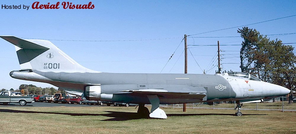
This preserved machine wore a rather unusual (for a Voodoo) ‘Hill’ low-viz scheme with toned-down markings, quite similar to the late USAF F-4 Phantom IIs of the early Eighties. The big aircraft looked quite good in this simple livery, and I kept the idea of a Hill scheme Voodoo in the back of my mind for some years until I recently had the opportunity to buy a cheap Matchbox Voodoo w/o box and decals. With its optional (and unique) RF-101B parts I decided to take the Hill Voodoo idea to the hardware stage and create another submission to the “Reconnaissance and Surveillance” group build at whatifmodellers.com around July 2021: an ANG recce conversion of a former two-seat interceptor, using the RF-101B as benchmark but with a different suite of sensors.
However, the Matchbox Voodoo kit is rather mediocre, and in a rather ambitious mood I decided to “upgrade” the project with a Revell F-101B as the model’s basis. This kit is from 1991 and a MUCH better and finely detailed model than the rather simple Matchbox kit from the early Eighties. In fact, the Revell F-101B is actually a scaled-down version of Monogram’s 1:48 F-101B model kit from 1985, with many delicate details. But while this downscaling practice has produced some very nice 1:72 models like the F-105D or the F-4D, the scaling effect caused IMHO in this case a couple of problems. Revell's assembly instructions for the 1:72 kit are not good, either. While the step-by-step documentation is basically good, some sketches are so cluttered that you cannot tell where parts in the cockpit or on the landing gear are actually intended to be placed and how. This is made worse by the fact that there are no suitable markings on the parts – you are left to guessing.
Worse, there is a massive construction error: the way the wings section is to be assembled and mounted to the hull is impossible! The upper wing halves have locator pins for the fuselage, but they are supposed to be glued to the lower wing half (which also encompasses the aircraft's belly) and the mounted to the hull. The locator pins make this impossible, unless you bend the lower wing section to a point where it might warp or break, or you just cut the pins off - and live with some instability. Technically the upper wing halves have to be mounted to the fuselage before you glue the lower wing section to them, but I am not certain if this would work well because you also have to assemble the air intakes at the same time “from behind”, which is only feasible when the wings have already been completed but still left away from the fuselage. It’s a nonsense construction! I cannot remember when I came across a kit the last time with such an inherent design flaw?
Except for the transplanted RF-101B nose section, which did not fit well because the Matchbox Voodoo apparently has a more slender nose, the Revell kit was built mostly OOB. However, this is already a challenge in itself because of the kit’s inherent flaws (see above), its complex construction and an unorthodox assembly sequence, due to many separate internal modules including the cockpit tub, a separate (fully detailed) front landing gear well, a rotating weapon bay, air intakes with complete ducts, and the wing section. A fiddly affair.
Only a few further changes beyond the characteristic camera fairing under the radome were made. The rotating weapon bay was faired-over with the original weapon pallet, just fixing it into place and using putty to blend it into the belly. The small underwing pylons (an upgrade that actually happened to some late Voodoos) were taken from a vintage Revell F-16. The SLAR antenna fairings along the cockpit flanks were created with 0.5mm styrene sheet and some PSR. They are a little too obvious/protruding, but for a retrofitted solution I find the result acceptable. The drop tanks came from the Revell kit, the underwing ordnance consists of an ALQ-119 ECM pod from a Hasegawa aftermarket set and a SUU-42 dispenser, scratched from a Starfighter ventral drop tank, bomb fins and the back of a Soviet unguided missile launcher.
Painting and markings:
Very simple and basic. While I originally wanted to adopt the simple two-tone ‘Hill’ scheme from the gate guard for my fictional Voodoo, I eventually settled for the very similar but slightly more sophisticated ‘Egypt One’ scheme that was introduced with the first F-16s – it just works better on the F-101’s surfaces. This scheme uses three grey tones: FS 36118 (Gunship Gray, ModelMaster 1723) for the upper wing surfaces, the “saddle” on the fuselage and the canopy area with an anti-glare panel, FS 36270 (Medium Grey, Humbrol 126) on the fin and the fuselage area in front of the wing roots, and FS 36375 (Light Ghost Grey, Humbrol 127) for all lower surfaces, all blended into each other with straight but slightly blurred edges (created with a soft, flat brush). The radome and the conformal antennae on the flanks became Revell 47 for a consistent grey-in-grey look, but with a slightly different shade. The model received an overall black ink washing and some post panel shading, so that the large grey areas would not look too uniform.
As an updated USAF aircraft I changed the color of the landing gear wells’ interior from green zinc chromate primer to more modern, uniform white, even though the red inside of the covers was retained. The interior of the flaps (a nice OOB option of Revell’s kit) and the air brakes became bright red, too.
The cockpit retained its standard medium grey (Humbrol 140, Dark Gull Grey) interior and I used the instrument decals from the kit – even though these did not fit well onto the 3D dashboards and side consoles. WTF? Decal softener came to the rescue. The exhaust area was painted with Revell 91 (Iron) and Humbrol’s Steel Metallizer (27003), later treated with graphite for a dirty, metallic shine.
Markings/decals primarily come from a 1:72 Hi-Decal F-4D sheet that contains (among others) several Texas ANG Phantoms from the mid-Eighties. Some stencils were taken over from the original Voodoo sheet, the yellow formation lights had to be procured from a Hasegawa F-4E/J sheet (the Matchbox sheet was lost and the Revell sheet lacks them completely!). The characteristic deep yellow canopy sealant stripes came from a CF-101 sheet from Winter Valley Decals (today part of Canuck Models as CAD 72008). I was lucky to have them left over from another what-if build MANY moons ago, my fictional CF-151 kitbashing.
Everything went on smoothly, but the walkway markings above the air intakes became a problem. I initially used those from the Revell sheet, which are only the outlines so that the camouflage would still be visible. But the decal film, which is an open square, turned out to be so thin that it wrinkled on the curved surface whatever I tried, and what looked like a crisp black outline on the white decal paper turned out to be a translucent dark blue with blurry edges on the kit. I scrapped them while still wet… Enter plan B: Next came the walkway markings from the aforementioned Winter Valley sheet, which were MUCH better, sharper and opaque, but they included the grey walking areas. While the tone looked O.K. on the sheet it turned out to be much too light for the all-grey Voodoo, standing out and totally ruining the low-viz look. With a bleeding heart I eventually ripped them off of the model with the help of adhesive tape, what left light grey residues. Instead of messing even more with the model I finally decided to embrace this accident and manually added a new black frame to the walkway areas with generic 2mm decal stripe material from TL Modellbau The area now looks rather worn, as if the camouflage had peeled off and light grey primer shows through. An unintentional result, but it looks quite “natural”.
The “Rhino Express” nose art was created with Corel Draw and produced with a simple inkjet printer on clear decal sheet. It was inspired by the “toenail” decoration on the main landing gear covers, a subtle detail I saw IIRC on a late CF-101B and painted onto the model by hand. With its all-grey livery, the rhino theme appeared so appropriate, and the tag on the nose appeared like a natural addition. It’s all not obvious but adds a personal touch to the aircraft.
Finally, after some more exhaust stains had been added to various air outlets around the hull, the model was sealed with matt acrylic varnish, position lights were added with clear paint and the camera windows, which had been created with black decal material, received glossy covers. The IRST sensor was painted with translucent black over a gold base.
Well, while the all-grey USAF livery in itself is quite dull and boring, but I must say that it suits the huge and slender Voodoo well. It emphasizes the aircraft's sleek lines and the Texas ANG fin flash as a colorful counterpoint, as well as the many red interior sections that only show from certain angles, nicely break the adapted low-viz Egypt One livery up. The whole thing looks surprisingly convincing, and the subtle rhino markings add a certain tongue-in-cheek touch.
Apparently I have developed a fascination with electric blue lately.
*My List of Movie Posters*
-Butterfly Effect
-Charlottes Web
-Eight Below
-Fallen (tv series)
-Iron Man
-Harold and Kumar
-Indiana Jones (4th)
-Burn After Reading
-The Ring Two
-Diary of a Mad Black Woman
-Man of the House
-White Noise
-Catwoman
-Disturbia
-The Reaping
-Evan Almighty
-License to Wed
-Oceans Thirteen
-Fantastic Four
-Live Free or Die Hard
-Children of Men
-Code Name: The Cleaner
-Dream Girls
-Stranger Than Fiction
-We are Marshall
-Electra
-Constantine
-The Bourn Ultimatum
-Stardust
-Chuck and Larry
-The Lovely Bones
-Ice Road Truckers (tv series)
-Sweeny Todd
-27 Dresses
-I am Legend
-National Treasure
-I Know Who Killed Me (banner)
final rinse 25 feet of hand developed 16mm / Bolex double 8mm Kodak 100D 7285 Motion Picture Film as loose coil
~3 minutes running time of 8mm footage at 24 fps
souped for 8 minutes at 100F in Tetenal E-6 kit using Paterson tank
Hot Tubbin at the Ski Lodge
Fernie, British Columbia, Canada
directed by Martin M.
All Rights Reserved 2013
Paillard Bolex P1 8mm 8 - 64 fps variable shutter camera
SOM Berthiot Pan Cinor 8-40mm f/1.9 zoom lens
Kodak 100D 7285 motion picture film
Telecine on Epson Perfection 4490 Flatbed Scanner at 48 bit 4800 dpi and Cine2Vid 24 fps
----
picture taken with Olympus PEN E-PM1
Leica Summicron M DR f2 50mm
Holga 120n
Ilford HP5 Plus
Developed in HC-110
I've been a horrible flickr contact as of late. Not a fan of the new flickr and not really any spare time. Hope you all will forgive me. I'll be catching up to everyone's stream shortly! :)
Please also check out my newest project over at www.hrcga.org Historic Rural Churches of Georgia
Developed in Microdol-X 1:3 16 MIn. 75 F.
Camera: Pentax K-1000
Lens: SMC Pentax-M 1.4/50
Film: Legacy Pro 100
Scanned from 2" x 5 1/2" lith print. Arista Liquid Lith Developer.
Fomatone MG Warmtone RC 332
SEE THE CAMERA AT THE LINK BELOW:
This is a capture of the beginning of the sunset that developed the first time I took out the new Panasonic to give it a test drive. I had hoped for a spectacular sunset, but noticed that the clouds that were just above the horizon were moving in very rapidly and so I grabbed this shot of the evening sky before I started heading for the car. I figured that it would just die and untimely death as the sun vanished behind the cloud bank, but did I have a surprise in store for me. I captioned this one DEVELOPING because of what happened after the sun disappeared behind the clouds. I might add that neither my new Sony A57 nor the new Panasonic FZ200 are capable of taking this shot into the sun as well as my antique Sony A700 with the Zeiss lens. Not quite the resolution of the newer cameras, but much more adjustable. I have some additional scenes in the sequence that I’ll be posting a bit later. Hope everyone is staying warm and no Gary, I WILL NOT be on the bayou tomorrow morning.
DSC03349uls
Nikon F3
Six Gates Films Orwell BW @400 iso
developed in Tmax dev 7''
epson v700
almost all of this picture were taken by Luca (Laszlo K.) while i was developing.
it has been a glorious day. We developed over 23 rolls of color negative cinema film in a vintage Morse G3 tank. We had some major fixing issue but we saved some good frames & had a good time.
Bottom line:
1)ECN2 is totally feasible for home processing
2) Morse G3 tank agitation could not be the best for these films.
3) we took a little step forward for DIY film photography