View allAll Photos Tagged Contribute
I finally got to visit the new Bespoke Community centre and decided play with the Neko Stray V2(squeee evox update and cool hud!)! It's gorgeous but of course it is, the designers are magical gods. I can't wait to contribute to the community with mods to my favorite mesh heads and avatars in the future. <3 MUAH you all.
/POSE/
Tsuki // Veena Static 2 pose
//BODY,HAIR//
BeSpoke - Neko Stray v2 / skin: Cream eyes: cat eyes 2
.STOIC. MANICURED CLAWS
AP: Handy Pawpads v1.0.1 (eB.Reborn)
MAZE.mods - Soft Thighs (both) (eBody Reborn)
REBORN - Waifus - Addon v1.0
REBORN by eBODY v1.69.6
VCO ~ NANDA Hair / Rigged /
//CLOTHING,ATTACH//
NI.JU // Ermine Ribbon Collar (no spikes)
.Malediction.Flora Thigh Ribbons
{Oiche} . Odette Dress {E.body Waifu Boobs}(tinted to purple from light pink)
~C.R~ Meowchi (Plate) (Attach) -server item
Ahhww the exhibition at the Holst & Holst Gallery was beautiful the many talented Photographers and their work ♥.♥
I feel very honored that I could contribute my part to the January exhibition. Thank you soo muche Peachy Holst & Torsten Holst ♥
A big thank you to my husband who always supports and inspires me. . . . I love you Marvin Graycloud 💋💋💋💋💋💋
To all my Friends and Familiar and of course my Followers without you nothing goes ♥♥♥
I send you all a lot of love your Sophie Graycloud
Visit: The Holst & Holst Photography Gallery
Flickr Group: Holst & Holst Photography in Second Life
Schooners lined up today for the start of the Great Chesapeake Bay Schooner Race. It was an overcast day with only a 5-7 knot wind so not a very dramatic start but still wonderful to see. This year there are 17 schooners actually racing and a few more that were anchored near the starting line. The race started with canon shot at 13:30 and by 20:00 they had barely gone 40 nautical miles. Will be a long night for this 115+ mile race.
The race is a fund raiser for bay conservation. Some of the vessels contributed but are not racing this year. Though most are from the mid-Atlantic states, we do have one competitor from the UK as well.
More pictures to come! Be sure to check out the whole set.
Left to right
When & If (yellow sails)
Principles
Liberty Clipper (dark green hull)
Lady Maryland (pink hull)
The race can be tracked here
www.baltimoremarinecenters.com/About-BMC/Schooner-Race-Tr...
List of the vessels here
A visit to New Jersey Transit's mainline brought a lot of backlighting and a couple of extras contributing to the maintenance of way operations.
The Rio della Ca'en Duo in Castello one of the six sestieri of Venice, Veneto, Italy.
The name Castello derives from fortifications located in the island of Olivolo, today the island of San Pietro di Castello, in the High Middle Ages.
There is the Basilica of San Pietro de Castello, the episcopal seat until 1807, the year of the transfer of the bishopric by Napoleon to the Basilica of San Marco, which until then had been the Doge's chapel used only for special occasions.
The Sestier de Castello is the most oriental of the city. It is divided in two by the imposing extent of land and water contained in the Arsenal, an old industrial engine and military-industrial complex serving the maritime power of the Serenissima.
Placed on the margins of the political center, Saint-Marc, and of the commercial center (Rialto) of the city, the Sestier always lived mainly on the activity of the Arsenal and on the maintenance and supplying needs of the ships; an activity that did not survive in the middle of the twentieth century when the technological development of production structures contributed to making this complex. inadequate.
The devastation and damage to the churches, convents and other buildings of the tip of Sant'Antonio and its surroundings in the nineteenth century led to the realization of the current public gardens and the realization of the Biennial of Art between 1894 and 1987.
The Pier Luigi Penzo Sports Stadium, the Francesco Morosini Naval Academy, and the urban area erected between 1924 and 1928 were built in the zone from the improvement of the lais around the small monastic island of Sant'Elena
Snorkling with Sea Lions off Floreana. It was amazing as they were so playful, one thought chewing on my flippers was a great game and another liked swimming really close and blowing bubbles in my face!
Galapagos Sea Lion
The Galápagos Sea Lion (Zalophus wollebaeki) breeds on the Galápagos Islands and – in smaller numbers – on Isla de la Plata (to Ecuador). Being fairly social, and one of the most numerous species in the Galápagos archipelago, they are often spotted sun-bathing on sandy shores or rock groups or gliding gracefully through the surf. Their loud “bark”, playful nature, and graceful agility in water make them the “welcoming party” of the islands. They are lightly smaller than their Californian relatives, Galápagos Sea Lions range from 150 to 250 cm in length and weigh between 50 to 400 kg, with the males much larger than females. Adult males also tend to have a thicker, more robust neck, chest, and shoulders in comparison to their slender abdomen. Females are somewhat opposite males with a longer, more slender neck and thick torso. Once sexually mature, a male’s sagittal crest enlarges, forming a small, characteristic bump-like projection on their forehead. Galápagos Sea Lions, compared to California sea lions, have a slightly smaller sagittal crest and a shorter muzzle. Adult females and juveniles lack this physical characteristic altogether with a nearly flat head and little or no forehead. Both male and female sea lions have a pointy, whiskered nose and somewhat long, narrow muzzle. The young pups are almost dog-like in profile. Another characteristic that defines the sea lion are their external ear-like pinnae flaps which distinguish them from their close relative in which they are often confused with, the seal. The fore-flippers have a short fur extending from the wrist to the middle of the dorsal fin surface, but other than that, the flippers are covered in black, leathery skin. Although somewhat clumsy on land with their flippers, sea lions are amazingly agile in water. With their streamline bodies and flipper-like feet, they easily propel themselves through crashing surf and dangerously sharp coastal rocks. They also have the ability to control their flippers independently and thus change directions with ease and have more control over their body on land. When wet, sea lions are a shade of dark brown, but once dry, their color varies greatly. The females tend to be a lighter shade than the males and the pups a chestnut brown. Born with a longer, brownish-black lanugo, a pup's coat gradually fades to brown within the first five months of life. At this time, they undergo their first molt resulting in their adult coat. Feeding mostly on sardines, Galápagos Sea Lions sometimes travel ten to fifteen kilometers from the coast over the span of days to hunt for their prey. This is when they come into contact with their biggest predators: sharks and killer whales. Injuries and scars from attacks are often visible. Galápagos Sea Lions are especially vulnerable to human activity. Their inquisitive and social nature makes them more likely to approach areas inhabited by humans, and thus come into contact with human waste, fishing nets, and hooks. They occupy many different shoreline types from steep, rocky cliff sides to low-lying sandy beaches. To avoid overheating during the day, sea lions will take refuge from the sun under vegetation, rocks, and cliffs, and wade into tidal pools. Not only are sea lions social, they are also quite vocal. Adult male Galápagos Sea Lions often bark in long, repeated sequences that are loud and distinctive. Females and juveniles do not produce this repetitive bark, but both sexes and the younger pups will growl. From birth, a mother sea lion recognizes her pup’s distinct bark and can pin point it from a crowd of thirty or more barking sea lions. On land, sea lions form colonies at their hauling-out areas. Adult males known as Bulls are the head of the Colony, growing up to 7 ft (2 m) long and weighing up to 800 lb (363 kg). As males grow larger, they fight to win dominance of a harem of between 5 and 25 cows and the surrounding territory. Swimming from border to border of his colony, the dominant bull jealously defends his coastline against all other adult males. While patrolling his area, he frequently rears his head out of the water and barks, as an indication of his territorial ownership. The average dominant bull holds his territory for only a few months, until he is challenged by another male. On land, these fights start by stretching out the neck and barking in attempt to test each other’s bravery. If this isn’t enough to scare the opponent off, they begin pushing each other and biting around the neck area. If males weren’t equipped with a thick, muscular neck, their vital organs would be easily damaged during these fights. Blood, is often drawn, however, and many male sea lions have battle scars due to these territorial competitions. Losers are dramatically chased far from their territory by the new dominant bull with much splashing. Because there is only one male in each harem, there is always a surplus of “bachelor” male sea lions. They usually congregate fairly peaceably on less favorable areas of the coastline in “bachelor colonies.”. Because the dominant male of the harem cannot feed while defending his colony, he eventually becomes too tired and weak, and is overpowered by the well-nourished, fresh bull. Breeding takes place from May all the way through to January. Because of this prolonged breeding season and the extensive care required by the pups from their mother, there are dependent pups in the colonies year round. Each cow in the harem has a single pup born a year after conception. After about a week of continuous attention from birth, the female returns to the ocean and begins to forage, and just a week after that, the pup will follow her and begin to develop its swimming skills. When the pup is two to three weeks old the cow will mate again. The mothers will take the young pups with them into the water while nursing until around the 11th month when the pups are weaned from their mother’s milk and become dependent on their own hunting skills. The pups have a strong bond with their mother. The cow will nurture a pup for up to three years. In that time the cow and the pup will recognize each other's bark from the rest of the colony. Within the colony sea lion pups live together in a rookery. Pups can be seen together napping, playing, and feeding. It is not uncommon to see one cow 'baby-sitting' a group of pups while the other cows go off to feed.
Floreana (Champions Islet)
Located approximately 4 to 5 hours west of Española and equal distance south of Santa Cruz, this island has long been a favorite site of visitors including pirates, whalers and early settlers. One of the oldest islands Floreana illustrates the aging process of a volcanic island. Unlike the younger western islands, Floreana's volcano has been long extinct and is in the advanced stages of erosion. The erosion process gave the island the nutrients and soils need to sustain plant life. The combination of this rich soil and a good water supply have given the highlands of Floreana a diversified landscaping of native and introduced flora. Floreana is best known for its colorful history of buccaneers, whalers, convicts, and colonists. In 1793 British whalers established the Post Office Barrel to send letters to and from England. This tradition has continued over the years, and even today visitors may drop off and pick up letters, without stamps, to be carried to far destinations. Punta Cormorant offers two highly contrasting beaches. The landing beach is of volcanic origin and is composed of olivine crystals, giving it a greenish tinge. At the end of the short trail is a carbonate beach of extremely fine white sand. Formed by the erosion of coral skeletons, it is a nesting site for green sea turtles. In the 1930's Floreana was the setting for intrigue and mystery. A German dentist and his mistress, a young family (the Wittmer family who still live on the island) and a self-styled baroness with three men came to settle in the island. Shortly after the baroness and her lovers arrived chaos began. The baroness and her entourage terrorized the other inhabitants while planning to build a luxury hotel. Eventually the baroness, two of her lovers and the dentist all turned up missing or dead. There has been much investigation searching for what really happened on Floreana, but there have never been any hard answers. John Treherne wrote of these people in "The Galapagos Affair". Located just off Punta Cormorant, Champions Islet is the best snorkeling in the Galapagos! To see the Devil’s Crown you need to go underwater, an almost completely submerged volcano, which erosion has transformed the cone into a series of jagged peaks creating the "Devil's Crown". The remains of the volcano create a haven for seabirds such as boobies, pelicans and frigates. Red-billed tropical birds can be seen nesting in the crevices. The highlight of the visit is snorkeling in the center of the crater. You will play with sea lions, while swimming with schools of colorful king angel fish, balloon fish, hawkfish, scrawled filefish, yellowtail grunts, tiger snake eels, white-tipped sharks, eagle rays, amberjacks, wrasses, hammerhead sharks, and sea turtles. The water is a bit rough and the current is strong. The east to west current provides a fun ride as it pushes you through the crown. There is a tube on the western side that you can swim through if you are a strong swimmer (approximately 10-15 feet down) and come out on the other side.
Galapagos Islands
The Galápagos Islands (official name: Archipiélago de Colón; other Spanish names: Islas de Colón or Islas Galápagos) are an archipelago of volcanic islands distributed around the equator in the Pacific Ocean, some 900 km west of Ecuador. It is a UNESCO World Heritage site: wildlife is its most notable feature. Because of the only very recent arrival of man the majority of the wildlife has no fear of humans and will allow visitors to walk right up them, often having to step over Iguanas or Sea Lions.The Galápagos islands and its surrounding waters are part of a province, a national park, and a biological marine reserve. The principal language on the islands is Spanish. The islands have a population of around 40,000, which is a 40-fold expansion in 50 years. The islands are geologically young and famed for their vast number of endemic species, which were studied by Charles Darwin during the voyage of the Beagle. His observations and collections contributed to the inception of Darwin's theory of evolution by natural selection.
Jerash, the Gerasa of Antiquity (Ancient Greek: Γέρασα, Hebrew: גַ'רַש), is the capital and largest city of Jerash Governorate (محافظة جرش), which is situated in the north of Jordan, 48 kilometres (30 mi) north of the capital Amman towards Syria. Jerash Governorate's geographical features vary from cold mountains to fertile valleys from 250 to 300 metres (820 to 980 above sea level, suitable for growing a wide variety of crops.
In the latter Ottoman period, the city of Jerash's name was abandoned and changed to Sakib, yet this was not a permanent development, as the name "Jerash" reappears in Ottoman tax registers by the end of 16th century.
A strong earthquake in 749 AD destroyed large parts of Jerash, while subsequent earthquakes along with the wars and turmoil contributed to additional destruction. Its destruction and ruins remained buried in the soil for hundreds of years until they were discovered by German Orientalist Ulrich Jasper Seetzen in 1806. He began excavation and a return to life of the current Jerash by inhabitants of older villages. 70 years later, this was followed by the Muslim community, Circassians, who emigrated to Jordan from the Caucasus in 1878 after the Ottoman-Russian war. Subsequently a large community of people from Syria came to the area at the beginning of the 20th century.
Gerasa es el nombre de una antigua ciudad de la Decápolis. Sus ruinas representan una de las ciudades romanas más importantes y mejor conservadas del Próximo Oriente, y se ubican en la región de Gilead, al noroeste de Jordania.
Recientes excavaciones muestran que Jerash ya estaba habitada durante la Edad del Bronce y la Edad del Hierro (3200 a. C. - 1200 a. C.). Después de la conquista romana, en el año 63 a. C., Jerash y sus contornos fueron anexionados a la provincia romana de Siria, y más tarde se integró en la Decápolis. En 90 d. C. se incorporó a la provincia de Arabia, que incluía la ciudad de Filadelfia (actual Ammán). Los romanos garantizaron la paz y la seguridad en el área, lo que permitió a sus habitantes dedicar su tiempo y sus energías al desarrollo económico y a la construcción. En la segunda mitad del siglo I, la ciudad de Jerash alcanzó una gran prosperidad. En 106 el emperador Trajano construyó calzadas que atravesaban las provincias, lo que incrementó las actividades comerciales de la ciudad. Adriano visitó Jerash en los años 129-130. Una inscripción latina registra la dedicatoria religiosa hecha por miembros de la guardia imperial que invernaron allí. El arco de triunfo -o Arco de Adriano- fue erigido para solemnizar la visita.
Jerash, situado 48 quilômetros ao norte de Amman, é considerado um dos maiores e mais bem preservados lugares da cultura romana no mundo, fora da Itália. Atualmente, suas ruas colunatas, banhos, teatros, praças e arcos permanecem em condição excepcional. Dentro dos restos das muralhas da cidade, arqueólogos encontraram as ruínas de estabelecimento datadas na época posterior ao Neolítico, indicando a ocupação humana nesta localidade para mais de 6500 anos. Isto não surpreende sendo que a área é situada idealmente para a habitação humana. Jerash, é bem abastecida de água, e sua altitude de 500 metros proporciona-lhe um clima temperado e uma excelente visão sobre as áreas mais baixas que rodeiam a cidade.
A história de Jerash é uma mistura do mundo greco-romano da bacia mediterrânea, e das antigas tradições da Arábia Oriental. De fato, o próprio nome da cidade reflete esta interação. Os habitantes Árabe-Semitas mais antigos, que habitavam na área durante o período pré-clássico do primeiro milênio BCE. chamavam sua aldeia Garschu. Os romanos posteriormente helenizaram o antigo nome árabe de Garschu para Gerasa, e a Biblia refere-se "à região dos Gerasenos" (Mk 5:1; Lc 8:26). No fim do século 19, os habitantes árabes e circanos dos pequenos estabelecimentos rurais transformaram a Gerasa romana em Jerash árabe.
Let me take you on a brief musical journey through my past... music has always been one of the most important components of my life. My dad is a guitarist and music lover, and his huge blaring stereo (all 500w of it) provided a constant background to my childhood. The first LP I bought was a Beatles compilation when I was about 8.
At the age of 10 I was in awe of Adam Ant. A year later I was a mod, dancing to The Who, The Jam and The Small Faces (and the odd bit of ska) at the local youth club.
By the time I got to my mid teens I was getting into metal (the heavier the better). Then later on indie, industrial, goth, etc. etc... But in between all that from the age of 12 to 14 I was really into this new style of music which you may have heard of called 'Hip Hop'.
My dad got me into rap in 1982, when he imported the first Grandmaster Flash album ('The Message') - his love of funk also contributing heavily (Prince Charles (the other one), George Clinton, early Prince, etc). But when rap really started breaking into the mainstream in the mid-80s, I lapped it up.
I would watch the movie 'Breakdance' on repeat play until the video broke; practice my (dire) human-beatboxing; and listen to my three favourite 12" singles:
- '(Nothing Serious) Just Buggin' ' by Whistle ;
- 'Bang Zoom! Let's Go Go!' by The Real Roxanne with Hitman Howie Tee;
- and the seminal 'The Show' by Doug E Fresh and the Get Fresh Crew (otherwise know as 'that song with the Inspector Gadget hook').
And here they still all are... complete with original price tags (£2.79p - from E.G.S and Son in Wakefield).
For a few years rap got better and better - and it almost seemed like it was growing and maturing with me (with the likes of Public Enemy and NWA). Which just makes me feel really bitter about all of the self-centred, 'Bitch/Ho/Bling' crap of the last fifteen years or so... But I guess it happens to all musical genres as they are subsumed by the marketing gurus and money men. The originators remain pennyless - but their morals intact - while the insipid pretenders milk the cash cow until it's dry. Give me Melle Mel over Jay Z anyday.
Gah... anyway. Listening to these EPs now just makes me feel young and FRESH all over again. Check it- check it out.
(Oh, and new prescription shades y'all!)
Podyjí National Park (Czech: Národní park Podyjí) is a national park in the South Moravian Region of the Czech Republic. It protects near-natural forests along the deep Dyje River valley. It is a biom whose well-preserved state is unique in Central Europe. It connects to the smaller Nationalpark Thayatal in Austria.
Podyjí National Park is characterized by extraordinary scenery, being home to features such as rocky amphitheatres, cliffs, meanders, detritus fields, impervious ravines, several types of heatland adorned with muilti-coloured layers of thermophilic plants, or alluvial plains around the river Dyje. The division of the valley along the river Dyje creates two distinctive ecological regions and thus contributes to the high biological diversity of the park.
-----
Did make a weekend (boat) trip across the Podyjí national park in late October to find it empty and silent on and around the Dyje river.
We were lucky with the weather: peak of autumn colours and delicate sunlight created a really fairy-tale atmosphere. It was (sometimes) cold on the river, however still very beautiful.
The Ontario County Courthouse is located in Canandaigua, New York, United States. The United States v. Susan B. Anthony trial took place in this courthouse in 1873. It is a contributing property to the Canandaigua Historic District, listed on the National Register of Historic Places in 1984.
Excerpt from the plaque:
The Last Shift by John McCaffrey: This piece was produced to honour and celebrate the many men and women of Collingwood who contributed their skills during a lifetime of work building ships at the “The Yard” (1883-1986)
The San Francisco Pride parade is a world-renowned LGBT pride parade. It is held on Sunday morning of the Festival. The route is usually along San Francisco's Market Street, from Beale Street to 8th Street.[1] The parade starts nominally at 10:30 am, though it is hours before all the contingents are able to get onto the parade route, and the last contingent doesn't leave the parade route until 2-4 pm.
The parade consists of hundreds of contingents from various groups and organizations. Some of the more well-known contingents are:
Women's Motorcycle Contingent, also known as Dykes On Bikes.[2] Several hundred motorcycle riders, all women. Some of the women are topless, some wear leather or fanciful costumes. The sound of hundreds of motorcycle engines gives this contingent a big impact. Part of the reason they are first in the parade is that it's difficult for motorcycles to run reliably at the walking pace of the rest of the parade, so as the first contingent they can move faster. On November 13, 2006, they won a battle to trademark the name "Dykes on Bikes", having struggled since 2003 to persuade the United States Patent and Trademark Office that "dyke" was not an offensive word.[3][4]
PFLAG, or Parents, Families, and Friends of Lesbians and Gays. Usually one of the largest contingents, featuring several hundred people. These are typically the (straight) parents or family members of LGBT people, sometimes marching together with their LGBT relatives. Many carry signs indicating where their PFLAG chapter comes from. It's common to see signs from all over Northern California. This contingent is notable for the swell in cheers (and some tears) that follow it along the route.
Politicians frequently participate in the parade, as a way of making themselves visible to LGBT prospective voters.
Churches of many denominations, or religious-oriented LGBT groups, contribute several dozen contingents.
Dance clubs and LGBT-oriented entertainment businesses contribute several contingents. It's common for a dance club to decorate a flat-bed truck or float, and have several people dancing on it, along with loud dance music.
The Leather Contingent consists of lesbian, gay and pansexual leather and BDSM groups.
Groups which are anti-gay typically do not have contingents. During the 1990s it was common to see anti-gay protestors in the spectator area along the parade route, holding large signs condemning homosexuality, often with biblical passages. In the 2000s such protestors have become less common.
Hundreds of thousands of spectators, if not over a million, line the parade route along Market Street. Some arrive hours in advance to claim a prime spot on the curb with a clear view of the street. Others climb onto bus shelters, the walls of subway station stairs, or scaffolding on buildings to get a clear view. As the parade ends, the spectators are able to pass through the barriers and march down Market street behind the parade. The end of the parade route is near the Festival location at the Civic Center.
The Engadine is a paradise for hikers in autumn.
The valley has plenty of sunny days, and it has mineral springs and a very pleasant climate. Piz Bernina is the only four-thousander in the eastern Alps (4,049 m. altitude). Piz Palü, Piz Corvatsch, Corviglia and Diavolezza are among its other well-known peaks and skiing areas.
Engadin St. Moritz has a fascinating cultural heritage - Romansch as its official main language, German spoken in St. Moritz, Italian in the neighboring valleys, French at the Club Med, lots of English for example at the Cresta Run, cricket and polo. Giovanni Segantini and the Giacomettis, Friedrich Nietzsche, Richard Wagner, Hermann Hesse, Thomas Mann, Arturo Toscanini, Richard Strauss, Herbert von Karajan and many other famous personalities from the worlds of the arts and culture have contributed to the myth und nimbus of this valley. 'Schlittedas', 'Chalandamarz', an own architectural style (the 'Engadine house'), and the famous Engadine nut tart are also a part of it all.
Early science results from NASA’s Juno mission to Jupiter portray the largest planet in our solar system as a complex, gigantic, turbulent world, with Earth-sized polar cyclones, plunging storm systems that travel deep into the heart of the gas giant, and a mammoth, lumpy magnetic field that may indicate it was generated closer to the planet’s surface than previously thought.
This image shows Jupiter’s south pole, as seen by NASA’s Juno spacecraft from an altitude of 32,000 miles (52,000 kilometers). The oval features are cyclones, up to 600 miles (1,000 kilometers) in diameter. Multiple images taken with the JunoCam instrument on three separate orbits were combined to show all areas in daylight, enhanced color, and stereographic projection.
Read more: go.nasa.gov/2rEgNhT
Credits: NASA/JPL-Caltech/SwRI/MSSS/Betsy Asher Hall/Gervasio Robles
NASA Goddard Space Flight Center enables NASA’s mission through four scientific endeavors: Earth Science, Heliophysics, Solar System Exploration, and Astrophysics. Goddard plays a leading role in NASA’s accomplishments by contributing compelling scientific knowledge to advance the Agency’s mission.
Follow us on Twitter
Like us on Facebook
Find us on Instagram
This is a detailed, 121 megapixel panorama of the San Francisco holiday skyline, shot on December 28 2016. I've been working on making as sharp and as detailed as possible; you can make out exit sign lights above doors at the SFMOMA 2.4km (1.5 miles) and 555 California 3km (1.9 miles) away and individual lights on the Bay Bridge 5.5km (3.4 miles) away. Thanks very much to Florian Kainz for all of his advice to get this as good as it could be :]
You can check out the full resolution version here: www.flickr.com/photos/captin_nod/32066278265/sizes/o/
The hardware used was nothing particularly special - a Canon 7D with the cheap, standard canon 70-300mm zoom lens at 260mm. I shot individual pictures at f/11, ISO 400 with a 1 second exposure (which underexposed most things about a stop). The panorama itself is shot from 46 individual images; and each one of these images consisted of locking off the camera and taking 4 photographs. In photoshop, these are exactly aligned and median filtered to reduce noise, remove motion artifacts from moving lights and recover a little dynamic range. I'd periodically switch the camera into live view to check that the focus of the lens was sharp. The process of shooting the images - the setup, calibration, checking focus and of course actual exposures - took a little under an hour.
After stitching, the image is around 50,000 pixels across. As expected, I wasn't able to completely eliminate all the things that could contribute to softness - nailing the focus, intrinsic shaking of the tripod & camera due to things like wind, and distortion due to heat haze and atmosphere. In the original panorama, there are large parts of the image that can be downsampled, resized back up and placed back in without any significant loss in quality. This 'empty resolution' means that I could wholesale resample the image to half it's size; this also had the effect of improving the signal to noise ratio a little, reducing the noise in the final image.
For the interactive panorama on Facebook (www.facebook.com/bjoshi/posts/10154212269427423), I used a modified version of Eric Cheng's fantastic PSD templates (www.facebook.com/notes/eric-cheng/editing-360-photos-inje...) to create a 6000 pixel wide, 300-degree-wide cylindrical panorama version of the image. It requires a little manual messing around with the XMP metadata to get it exactly where I wanted it (my image is not very tall); ping me in the comments below if you want more details or help figuring it out.
For those of you that have grabbed the original image from Flickr with the intent of printing or using commercially - please don't, and buy the image or hire me instead. I shoot high quality imagery at very reasonable rates. I'm easy to find, drop me a line.
Just in case this alone doesn't deter you, in the online copies of the photograph I've hidden (in plain sight) in a range of highly offensive imagery that would be extremely embarrassing and difficult to explain to a client. Have fun trying to find it all because I guarantee you can't :]
The Hubble Space Telescope has snapped the closest images yet of the sky's latest visitor to make headlines, comet NEOWISE, after it passed by the Sun. This is the first time Hubble has photographed a comet of this brightness at such resolution after this close of a pass by the Sun.
This ground-based image of comet C/2020 F3 (NEOWISE) was taken from the Northern Hemisphere on July 16, 2020. The inset image, taken by the Hubble Space Telescope on Aug. 8, 2020, reveals a close-up of the comet after its pass by the Sun. Hubble’s image zeroes in on the comet’s nucleus, which is too small to be seen. It’s estimated to measure no more than 3 miles (4.8 kilometers) across. Instead, the image shows a portion of the comet’s coma, the fuzzy glow, which measures about 11,000 miles (18,000 kilometers) across in this image.
The comet photos were taken after NEOWISE skimmed closest to the Sun on July 3, 2020, at a distance of 27 million miles (43 million kilometers). Other comets often break apart due to thermal and gravitational stresses at such close encounters, but Hubble’s view shows that apparently NEOWISE’s solid nucleus stayed intact.
Comet NEOWISE is considered the brightest visible from the Northern Hemisphere since 1997’s Hale-Bopp. It’s headed beyond the outer solar system, now traveling at a whopping 144,000 miles per hour. It will not return to the Sun for another nearly 7,000 years.
Credits: NASA, ESA, STScI, Q. Zhang (Caltech); ground-based image copyright © 2020 by Zoltan G. Levay, used with permission
www.nasa.gov/feature/goddard/2020/hubble-snaps-close-up-o...
NASA Goddard Space Flight Center enables NASA’s mission through four scientific endeavors: Earth Science, Heliophysics, Solar System Exploration, and Astrophysics. Goddard plays a leading role in NASA’s accomplishments by contributing compelling scientific knowledge to advance the Agency’s mission.
Follow us on Twitter
Like us on Facebook
Find us on Instagram
Contributing to the potent, ethereal magic present was this happy coincidence.
Possibly a slightly jarring composition, the picture still had to be taken for obvious reasons.
The utter contrast to mundane daily life that these experiences gift to the onlooker cannot be stressed sufficiently. The usual melancholy kicked in as I gazed in wonder at my situation: the impossibility of 'bottling it all up' & taking some of it home proving to amplify an already raised state of emotion.
FDR Powwow: NATIVE AMERICAN HERITAGE FESTIVAL - September 27th & 28th, 2008.
*********************************************************************************************
FDR State Park
Yorktown Heights, Westchester, NY
In case you weren't aware, November is Native American Indian month in the United States and time is quickly Running Out.
In the 2008 presidential proclamation
designating this year’s National American Indian Heritage Month, the President of the United States wrote, “I call upon all Americans to commemorate this month with appropriate programs and activities.”
Whether your “appropriate programs and activities” are school programs, special events, letters to the editor, blogging, or personal ambassadorship for Native American culture, there’s still time to get involved!
Visit the Native Americans Rights Fund's (NARF) Native American Month Campaign page for suggestions of how to make this month meaningful in your community: narf.convio.net/site/PageServer?pagename=Modern_Day_Warri...
Wherever the rights, culture, or environment of Native Americans are threatened and NARF is there to stand up for what’s right to make governments at all levels respect the agreements made with native peoples.
Many thanks for your support,
John E. Echohawk
Executive Director
*********************************************************************************************
ANYONE INTERESTED IN LEARNING ABOUT THANKSGIVING from A First PEOPLE'S PERSPECTIVE please read:
First Voices Indigenous Radio on WBAI NY / Radio Pacifica
Thursdays, 10 AM to 11 AM ---> wbai.org/
Host: Tiokasin Ghosthorse
Web site: www.firstvoicesindigenousradio.org
Email: Tiokasin@gmail.com (This e-mail address is being protected from spam bots, you need JavaScript enabled to view)
Voicemail: (212) 209-2979
First Voices broadcasts are available on CD. Contact using email/phone above.
Program description:
First Voices Indigenous Radio brings to the airwaves the experiences, perspectives and struggles of Indigenous people who have been almost totally excluded from both mainstream and progressive, alternative media. Our purpose is to help ensure the continuance and survival of Indigenous cultures and Nations by letting the People tell their own story, in their own words, and often in their own languages and ways of speaking. And with as little outside interference and interruption as possible.
As we open up the airwaves week after week to the voices seldom heard in the last 511 years, it is our hope that the newcomers to this Land - that is, every immigrant group - will begin to question their assumptions about Indigenous people here. We hope they become educated and informed, get activated, break down their romanticization, break free of their stereotypes, and begin to form real relationships with Indigenous communities based, finally, on respect and real understanding.
This one hour is devoted to bringing the voices of the Indigenous Peoples of Turtle Island (i.e., North America) and connecting their struggles with those of other Indigenous Peoples around the world. And while never forgetting that standing upon Mother Earth is a great responsibility.
We ask our guests with great respect to do the honor of coming on the program to offer their knowledge, wisdom, and experience, a knowledge that has been handed down over hundreds of thousands of years. It is a responsibility we take very seriously, and we know it is with great urgency that we ask these voices to be shared in this time of changes. We hope we offer our listeners a perspective they have been missing for far too long. The voice America has tried to silence, the voices of Indigenous Peoples.
Tiokasin knows that First Voices Indigenous Radio belongs to all the Native Peoples here in Turtle Island (renamed North America by the occupiers). The responsibilities that can be taught by listening to the real land owners(so to speak) and understanding the knowledge, the wisdom, the struggles, and the unheard voices .
It is said that if the lies continue about Native peoples it will create an illusion that all Americans will dearly pay for in the future...and the future is now. What kind of world are Americans creating with their privilege of denying Native people's voice and the reality of truth that Natives experience daily.
Tiokasin's global perspective reality is the experience of living with and understanding these two worlds - Indigenous and non-Indigenous. The teachings of the Lakota are profound and relevant in the universe today! Lakota knowledge empowers through inclusion, by teaching responsibility of choices. This contributes to an emerging world, affecting the environmental/Mother Earth issues we as human beings ponder when it comes to what it means to be civilized.
Host/producer profile: Tiokasin Ghosthorse
Tiokasin Ghosthorseis host and producer of First Voices Indigenous Radio. He spoke, as a teenager, at the United Nations Conference on Human Rights International Covenant on Economic, Social, and Cultural Rights in Geneva, Switzerland. He participated in several occupations including Wounded Knee, SD in 1973, Lyle Point, WA, Western Shoshone, NV, and Big Mountain, AZ, and has been actively educating people who live on Turtle Island (N. America) and overseas since that time. Tiokasin is also a survivor of the "Reign of Terror" from 1972-1976 on the Pine Ridge Lakota Reservation, the U.S. Bureau of Indian Affairs Boarding and Church Missionary School systems designed to "kill the Indian and save the man".
*********************************************************************************************
photograph: A. Golden c. 2008.
Be the first to kick start your generous support and fund my production with more amazing images!
Currently, I'm running a crowd funding activity to initiate my personal 2016 Flickr's Project. Here, I sincerely request each and every kind hearted souls to pay some effort and attention.
No limitation, Any Amount and your encouraging comments are welcome.
Crowd funding contribution can be simply direct to my PayPal account if you really appreciate and wish my forthcoming photography project to come alive.
Please PayPal your wish amount to : men4r@yahoo.com
Email me or public comments below your contribution amount for good records with your comments and at final day, at random, I shall sent out my well taken care canon 6D with full box n accessory during random draw to one thankful contributor as my token of appreciation.
Now, I cordially invite and look forward with eagerness a strong pool of unity zealous participants in this fundermental ideology yet sustainable crowd fund raising task.
Basically, the substantial gather amount is achievable with pure passion n love heart in photography and not necessary be filty rich nor famous to help me accomplish raising my long yearning photography career, a sucking heavy expense that been schedules down my photography making journey had inevitably, some circumstances had badly fall short behind racing with time and inability to fulfill as quickly in near future consolidating good fund .
Honestly, with aspiration and hope, I appeal to urge on this media for a strong humanity mandate through good faith of sharing and giving generously on this particular crowd funding excercise to achieve my desire n is not just purely a dread dream , is also flickers first starter own crowds funding strength turning impossible into reality through this pratical raising method that I confidently trust it will turn fruitful from all your small effort participation, every single persistency will result consolidating piling up every little tiny bricks into an ultimate huge strong living castle.
In reality, I have trust and never look down on every single peny efforts that been contributed as helpful means, turning unrealistic dream alive is the goal in crowd funding excercise, No reason any single amount is regard to be too small when the strength of all individual wish gather to fulfill my little desire to make exist and keep alive. .
I sincerely look forward each and every participants who think alike crowds funding methodlogy works here no matter who come forwards with regardless any capital amount input be big or small , please help gather and pool raise my objective target amount as close to USD$10K or either acquisition from donation item list below:
1- ideally a high mega pixel Canon 5DS ( can be either new or use ok)
2- Canon 70-200mm F2.8 L IS lens ( can be either new or use ok)
Last but not least, a photography journey of life time for a trip to explore South Island of New Zealand and Africa.
.
My intended schedule may estimate about 1 month round trip self drive traveling down scenic Southern Island of New Zealand for completing the most captivating landscape photography and wander into the big five, the wilderness of untamed Africa nature for my project 2016 before my physical body stamina eventually drain off.
During the course, I also welcome sponsor's to provide daily lodging/accommodation, car rental/transportation, Fox Glacier helicopter ride and other logistic funding expenses, provide photographic camera equipments or related accessories .
Kindly forward all sponsors request terms of condition n collaboration details for discussion soon.
Great Ocean Drive- the 12 Apostle's
Please Click Auto Slide show for ultimate viewing pleasure in Super Large Display .to enjoy my photostream . ..
Due to copyright issue, I cannot afford to offer any free image request. Pls kindly consult my sole permission to purchase n use any of my images.You can email me at : men4r@yahoo.com.
Don't use this image on Websites/Blog or any other media
without my explicit permission.
For Business, You can find me here at linkedin..
Follow me on www.facebook.com here
This climate-friendly bio degradable fibre can contribute to reduce carbon emission. Traditionally Bangladesh was famous for jute production, which is mainly used for producing bags, sacks and many other materials. The fibre and the stalks are now processed for interior materials for high end vehicles. The introduction of plastics made the jute production almost extinct in Bangladesh. It is now reviving because of growing demand of natural fibre throughout the world. Which bags do you use during shopping?
The photo was taken in a remote village of Satkhira, Bangladesh. The farmer is processing the fibre with the use of flowing monsoon water.
Eastern Whipbird -Psophodes olivaceus
Having mostly-green plumage and living in the dense undergrowth, the Eastern Whipbird is seen far less often than it is heard. Its whip-crack call is a characteristic of many of the moist forests in eastern Australia. The unusual feature of this call is that it is often performed by two birds calling in unison, with one bird contributing the first part of the call and another giving the second part. This so-called ‘antiphonal’ calling involved great co-ordination between the two birds to give the call its familiar whip-crack sound.
Welcome to Wikwemikong Unceded Indian Reserve, one of the ten largest First Nation communities in Canada.
Situated on the eastern end of Manitoulin Island and pristine shores of Georgian Bay, Wikwemikong is home to a vibrant aboriginal community with a rich history dating back to the mid 1600s.
Our unique heritage was originally founded on the almalgamation of three tribal nations; Odawa, Pottawottomie and Ojibway.
The Anishnabek people of Wikwemikong are citizens of the Three Fires Confederacy: an alliance of Odawa, Ojibway and Pottawatomi nations. The Odawa inhabited Manitoulin Island or “Mnidoo Mnis” for many years prior to any other tribal settlements; it has been referred to as Odawa Mnis”. Manitoulin Island has also been called “Ogemah Mnis”, the home of the ancestors as recorded by many chiefs having been buried here. The Ojibway arrived in Wikwemikong during the 1850s era treaties. These families continue to reside and contribute to the community.
In 1832, three Pottawatomi families were already settled in Wikwemikong. With the ratification of the 1833 Treaty of Chicago in 1835, the U.S. government agents forced the Pottawatomi and neighbouring tribes to sell their land. More than 3,000 Anishnabek consequently left their homelands. Pottawatomi families began to arrive in Canada around this time. Concurrently in 1836, the main objective of the Bond Head Treaty was to initiate the migration of Upper Canada Indians to Manitoulin Island where they could live free from the influences of the encroaching white civilization.
The Upper Canada Indians did not migrate to Manitoulin Island as intended. Therefore, in 1862, the Mcdougall Treaty was initiated and signed. This treaty targeted the surrender of unsold lands on Manitoulin Island. Wikwemikong did not sign the treaty and thus it became known as an Unceded Indian Reserve. In 1968, an amalgamation took place among three bands: Manitoulin Island Indian Reserve, Point Grondine and South Bay. This amalgamation created the Wikwemikong Unceded Indian Reserve.
The people of Wikwemikong take great pride in the living history, culture and language of their community and in the diverse traditional arts that are present. In 2006, the citizens of Wikwemikong formally implemented a community-based Anishnaabemowin Language Strategy to retain our language for all future generations. It was also during this time that the Department of Canadian Heritage designated Wikwemikong as one of several Cultural Capitals of Canada. (From:http://www.wikwemikong.ca)
© all rights reserved by Mala Gosia. Please do not use this image on websites, blogs or any other media without my explicit written permission.
The rare Purple Martin, a member of the swallow family return from South America in late April every year. During the winter they soak up the sun east of the Andes in Columbia, Bolivia and Brazil.
OASES (Organization Advocating Sanctuary for Endangered Species) has contributed funds and labour for adding and maintaining nest boxes at the Tod Inlet colony for a number of years.
In 1985, there were 5 breeding pairs of western purple martins left in the wild, now there are nearly a 1000 thanks to those nest boxes located in various safe locations.
The nest boxes are located very high up on pilings to ensure that the Purple Martins have a safe location away from land predators.
A view looking north from Prairie Lea St. at the west side of the 200 block of S. Main St. in downtown Lockhart. My previous post shows this block looking south from Market St. All of the buildings in this view are contributing properties in the Caldwell County Courthouse Square Historic District listed in the National Register of Historic Places in 1978.
On the corner is the Dr. Eugene Clark Public Library, the oldest continuously operating public library in the State of Texas. Built in 1899 and dedicated on July 6, 1900, this library was financed with funds bequeathed by Dr. Clark, who was a prominent physician of Lockhart and San Antonio. His will left $10,000 to the people of Lockhart, of which $6,000 was to be used for construction, $1,000 to buy books and the remainder was to be put in a trust to maintain the building and purchase new books. A native of New Orleans, Dr. Clark was a graduate of Tulane Medical School and studied in Vienna, Austria. He was an eye, ear, nose, and throat specialist. He died, while still a young man, in New York City in 1897.
President William Howard Taft once spoke from the stage in the library and operatic soprano and musical theater actress Dorothy Sarnoff has performed here, remarking to her audience, "If you are bored with my performance tonight, you can just reach over and grab a good book to read." Many local community groups and organizations held theatrical productions, recitals and concerts in the library. The Local Community concert group held seasonal programs in the building until 1956.
The two-story Greek cross plan library is a Classical Revival building of red brick with limestone trim. Four projecting pedimented pavilions form the arms, while entrances are found at
the southeast, southwest and northeast intersections. On the main (east) facade, the pavilion, divided into three bays by pilasters, contains a central, stained glass memorial windows classically framed by pilasters and a round keystone arch. The southeast (main) entrance has double doors with a multi-lighted fanlight also framed by the pilasters and keystone arch. Crowning the building an octagonal drum, embellished by pilasters and entablature, supports the central dome. The building was designed and built by T. S. Hodges, who also designed the castle-like Caldwell County Jail.
The three-story red brick building with white stone trim standing to the north of the library is the old Masonic Temple built in 1925 for Lockhart Masonic Lodge #690. The building is now used for commercial purposes.
Lockhart, a community of 14,811 at the 2020 census, is the seat of Caldwell County and is located just 30 miles south of the state capital in downtown Austin. Lockhart's square and downtown is filled with late 19th and early 20th century buildings, nearly all contributing properties to the historic district. The city's turn-of-the-century appearance has attracted the attention of film makers. Over 50 films for the theater and TV have been shot in whole or in part in Lockhart, including the 1996 Christopher Guest comedy film Waiting for Guffman and the 1993 drama What's Eating Gilbert Grape.
A Northrop Grumman Antares rocket carrying a Cygnus resupply spacecraft is seen as it is transported to the Mid-Atlantic Regional Spaceport’s Pad-0A, Saturday, September 26, 2020, at NASA's Wallops Flight Facility in Virginia. Northrop Grumman’s 14th contracted cargo resupply mission with NASA to the International Space Station will deliver about 8,000 pounds of science and research, crew supplies and vehicle hardware to the orbital laboratory and its crew. The CRS-14 Cygnus spacecraft is named after the first female astronaut of Indian descent, Kalpana Chawla, and is scheduled to launch at 9:38 p.m., Thursday, October 1, 2020 EDT.
Photo Credit: (NASA/Terry Zaperach)
NASA Goddard Space Flight Center enables NASA’s mission through four scientific endeavors: Earth Science, Heliophysics, Solar System Exploration, and Astrophysics. Goddard plays a leading role in NASA’s accomplishments by contributing compelling scientific knowledge to advance the Agency’s mission.
Follow us on Twitter
Like us on Facebook
Find us on Instagram
"Die Letzte Hoffnung" is a forced union of four North German musicians in what one would actually think of as their best age. The baritone saxophonist and bass clarinetist Hauke Schlüter, the guitarist Jens Rathfleder, the bassist Michael Haupt and the drummer Jannik Stock, however, have found themselves in the abysses of contemporary jazz, in gloomy to headstrongly cheerful sound fields and thus usually in the deepest and darkest cellars of Northern Germany. They develop a music full of contrasts and a wide playful range from melancholic ballads and fragile sounds to free spheres and raging rock passages. The quartet cultivates an open sound, leaving room for interpretation for the listener as well as for the emotional development of the players. Not playing takes up at least as much space in their music as playing a tone. Highly communicative, spontaneous and willing to take risks, yet firmly rooted in the jazz tradition, the playing of the four instrumentalists is without doubt a very special listening experience. The compositions are contributed by the deep woodwind player Hauke Schlüter and the guitarist Jens Rathfelder. In the truest sense of the word "playful" is often the way the four musicians deal with these compositions, which are never performed on two evenings at once.
Yesterday I purchased a 500 piece puzzle at the local bookstore. Amazingly, all the girls contributed to its assembly. Skye did a fantastic job!! It took us about 2 hours.
My SB600 speedlight was next to the puzzle at lower left.
Do yourself a favor and view this one large!
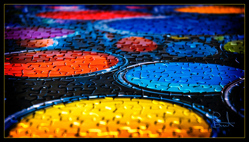
#1 on Explore for Saturday, March 22, 2008!! Thank you everybody.
This species has a much narrower mouth than the White Rhino but shares its overall gray color. Rhinos have poor vision but this female apparently caught our scent and immediately took off in the opposite direct. It was with a nearly full grown calf which may have contributed to its shyness.
Von Mitte des 16. Jhs. bis 1606 waren an dieser Stelle nur
Kapellen gebaut worden. Mit dem Planungsbeginn sollte für
das bereits vorhandene Jesuitenkolleg ein Kirchenneubau geschaffen werden. Johann Alberthal war der Planer der nach Konzepten des Jesuitenkollegs arbeitete. Als gesichert gelten die Einflüsse der Augsburger Architekten Heintz, Holl und Krager bei der Endauswahl der Entwürfe.
Es sollte die zweite (renaissance/barocke) Wandpfeilerkirche
auf deutschem Gebiet und somit zur Vorlage für viele folgenden Kirchenbauten werden! Die Weihe fand 1617 statt. Erst ca. 140 Jahre später wurde der Innenraum umgestaltet und mit der hier zusehenden Rokokoaustattung versehen. Der leitende Dekorateur, wahrscheinlich Christoph Thomas Scheffler, verstand es den Raum ohne stark verändernde Eingriffe in die Substanz hervorragend auszunutzen. Die Liste der Künstler die am Gelingen Anteil hatten ist lang und voller bekannter Namen: ich möchte sie dem Leser allerdings ersparen...
From the middle of the 16th century until 1606 there were only
Chapels have been built. With the beginning of the planning for
the already existing Jesuit College a new church building will be created. Johann Alberthal was the planner who worked according to the concepts of the Jesuit College. The influences of the Augsburg architects Heintz, Holl and Krager in the final selection of the designs are regarded as certain.
The second (renaissance/baroque) wall pillar church on German territory was to be built and thus become the model for many of the following church buildings! The consecration took place in 1617. Only approx. 140 years later the interior was redesigned and provided with the Rococo equipment watching here. The leading decorator, probably Christoph Thomas Scheffler, knew how to use the room excellently without any major alterations to the substance. The list of artists who contributed to the success is long and full of well-known names: I would like to spare them to the reader though...
Caltabellotta stands at an altitude of about 900m. Its Arab name, Kalat-al-Ballut (Oaks’ Rock) evokes the look of the village that is perched atop a rock. Its dominant position contributed to protect it from the attacks of enemies throughout the centuries
Are you an optimist or a pessimist...what is your point of view?
"Both optimists and pessimists contribute to our society. The optimist invents the airplane and the pessimist the parachute." ~Gil Stern
Germany, Wedel, the River Elbe near Hamburg,
one of the remaining last few fish trawlers on the Elbe.
Fishing on the Lower & Outer Elbe is of considerable importance for the region & with its environmentally friendly technology, is exemplary within the European Union.
The preservation of fisheries also serves environmental protection, because it ensures a lasting interest in sufficient water quality, biodiversity & efficiency of the aquatic habitats, it can thus contribute to an improvement in water ecology.
👉 One World one Dream,
🙏...Danke, Xièxie 谢谢, Thanks, Gracias, Merci, Grazie, Obrigado, Arigatô, Dhanyavad, Chokrane to you & over
17 million visits in my photostream with countless motivating comments
The Philippine duck (Anas luzonica) is a large dabbling duck of the genus Anas. It is endemic to the Philippines. As few as 5,000 may remain. Overhunting and habitat loss has contributed to its decline.
Slimbridge Wetland Centre
Thank you for taking the time to view or comment on my Photostream, it is appreciated.
Apollo 11 Mission image - View of the Lunar Module at Tranquility Base. Image taken by Astronaut Neil A. Armstrong during the Apollo 11 Mission. Armstrongs shadow is visible in foreground.
Credit: NASA
NASA Goddard Space Flight Center enables NASA’s mission through four scientific endeavors: Earth Science, Heliophysics, Solar System Exploration, and Astrophysics. Goddard plays a leading role in NASA’s accomplishments by contributing compelling scientific knowledge to advance the Agency’s mission.
Follow us on Twitter
Like us on Facebook
Find us on Instagram
The New York State Capitol is the capitol building of the U.S. state of New York. Housing the New York State Legislature, it is located in the state capital city Albany as part of the Empire State Plaza on State Street in Capitol Park. The building, completed in 1899 at a cost of $25 million (worth approximately half a billion current dollars), was the most expensive government building of its time.[citation needed] It was listed on the National Register of Historic Places in 1971, then included as a contributing property when the Lafayette Park Historic District was listed in 1978. The following year it was declared a National Historic Landmark
For centuries the Gkuthaarn and Kurtijar have lived in the Normanton area. They hunted across the wetlands, trapped fish in the shallows, held ceremonies, and resolved disputes in time honoured ways.
That changed in the mid 19th Century when European explorers wrote favourably of the Gulf region's pastoral opportunities. Normanton was soon established as a port town with coastal shipping skirting the wetlands on their trip up the river to the old wharf near the bridge.
A meatworks operated near Goose Lagoon from the 1890s to the early twentieth century. Although mainly slaughtering cattle for tallow it possibly contributed to the wetland's name as sheep grazing was attempted early on.
The alluvial plains of the Gulf are dotted with lagoons and shallow mounds know as Gilgai. Silt is deposited during floods and, during the dry season, soil commonly cracks and flakes. During high tides, salt water flows into some of the lagoons and low-lying areas.
The Mutton Hole Wetlands are 78km2, and form a part of the Gulf Plains which cover the equivalent of half the area of Victoria or Great Britain. They are the most accessible part of this fascinating region of winding rivers, floodplains, and waterholes.
Annual rainfall averages 911mm with most falling between January and March. Falls can exceed 250mm a day. Its feast or famine; the rest of the year it is virtually dry. By comparison Brisbane and Sydney average around 1200mm, but spread throughout the year.
With high rainfall and floodwaters pouring down the Norman River the area can quickly turn into a huge sheet of water. This area is sometimes several metres underwater.
Summer temperatures fluctuate around a steamy 30+ Degree C but average dry season temperatures range from 29 Degrees C during the day to 16 Degrees C at night.
The Wetlands may seem challenging for plant life but Coolibah (Eucalyptus microtheca) and Gutta Percha (Excoecaria parvifolia) dominate the woody higher ground. Along the lagoon shores numerous reeds and grasses flourish and on the salt flats you can find succulents like Tecticornia australasica. Over twenty different fish species have been recorded in the lagoons. The flathead catfish found in the 2008 wrt season was new to science. The wetlands are important nursery habitats for banana prawns and barramundi. Snakes, crocodiles, and wallabies also live in and around the lagoons and waterholes, with feral pigs and cats often found when food is abundant.
Over 120 species of birds call it home or use it seasonably as they travel across the world. The waters are home to many fishes and amphibians and on land wallabies, pigs, and dingoes roam.
Birds found in the Wetlands include:
The Apostle bird, that hand around in chattering flocks. Some say flocks of twelve are common, hence their name, but studies suggest smaller groups are normal.
Australian Bustards wander around grassy plains or in small flocks. One bush yarn recounts that old timers hunted them (which is now illegal) by wandering around them in a wide circle. The over inquisitive birds ring their own necks watching what is happening.
The Black Necked Stork is a stately stork bird also known as the Jabiru and stands about 1200mm high. They prefer a lone existence and enjoy a fish, frog, and carrion diet. They linger around the waterhole margins.
The Brolga has a red head and grey neck and bodies whereas the rare Sarus crane has aed extending down their neck. They often congregate together and dance. Sarus cranes are among the rarest cranes in the world with possibly only two thousand remaining. The Mutton Hole Wetlands is a breeding ground for both the Brolga and Sarus crane.
Double Bar Finch's flock enjoy seeding grasses. They enjoy frequent drinks and therefore keep close to the water.
The Great and Little Egrets perch in the trees around waterholes or wade through the shallows. The Great Egret stands about 800mm high while the Little Egret, with its black bill, is around 560mm.
Flocks of Magpie Geese honk noisily to one another while feeding or formation flying. A male may have two sisters as its partner. Their feet are only partially webbed, hence their scientific name: Anseranus semipalmata.
Pied Herons like the edges of waterholes and being around livestock. They enjoy an insect diet. Another name for them is the 'white headed egret', despite the fact the top of the head is a blue black.
Radjah Shelducks, also known as Burdekin ducks, are birds that have a dark band across the otherwise white upper breast. They are active feeders late in the date and dislike others invading their territory.
The Swamphen's big feet enable these distinctive birds to wander through dense reed beds. Their white undertail is often seen as it flicks its tail when altered.
The Pied Butcherbird frequents open country and is a stunning singer. Youngsters stay with their parents for around 18 months.
The Whimbrel arrives in Australia around August/September and leaves for Siberia in May, where it breeds, although some youngsters prefer to stay in Northern Australia. Whimbrels enjoy poking in muddy ground for worms and small shellfish.
Source: Carpentaria Shire, Queensland Government.
Casa Batlló (Catalan pronunciation: [ˈkazə βəˈʎːo]) is a renowned building located in the centre of Barcelona and is one of Antoni Gaudí’s masterpieces. A remodel of a previously built house, it was redesigned in 1904 by Gaudí and has been refurbished several times after that. Gaudí's assistants Domènec Sugrañes i Gras, Josep Canaleta and Joan Rubió also contributed to the renovation project. The local name for the building is Casa dels ossos (House of Bones), as it has a visceral, skeletal organic quality.
Like everything Gaudí designed, it is only identifiable as Modernisme or Art Nouveau in the broadest sense. The ground floor, in particular, has unusual tracery, irregular oval windows and flowing sculpted stone work. There are few straight lines, and much of the façade is decorated with a colorful mosaic made of broken ceramic tiles (trencadís). The roof is arched and was likened to the back of a dragon or dinosaur. A common theory about the building is that the rounded feature to the left of centre, terminating at the top in a turret and cross, represents the lance of Saint George (patron saint of Catalonia, Gaudí's home), which has been plunged into the back of the dragon.
Candles in memory of loved ones all over the world ~
We paused today on All Saints' Day to remember our loved ones who have gone on ahead of us. This season brings the bittersweet of memories- days with Jamie and others, thoughts so fleeting they seem like dreams . . .
This little turtle was a special gift from my wonderful Flickr friend, Kelly Dilello-Smith- Jamie's totem animal!
In our own personal remembrances, many MANY of your loved ones have been remembered along with ours.
Thank you all for contributing to my survival here. Life has been hard but this virtual community continues to bouy me up.
With love and thoughts for you all ~ Kim
Excerpt from stcatharines.ca:
The Former Maple Leaf Rubber Company Building (Lincoln Fabrics) at 63 Lakeport Road, built in 1898, is the largest remaining structure from Port Dalhousie’s industrial past, and is highly visible in several key views. It formerly had a second wing and tower. The business was on the site from 1886, employing as many as 300, the present building was built after an 1898 fi re. From 1915 to 1927 it was operated as Canadian Consolidated Rubber company, closing after opening of the Fourth Canal ended shipping to the site. Since then it has been occupied by several industrial enterprises, Lincoln Fabrics from 1955 to 2016. It contributes to the District as the largest surviving industrial building, as an important landmark visible from several vantage points, with heritage attributes including its relationship to the former Welland Canal, its Edwardian brick facades, regularly spaced double hung windows with elliptical tops on all facades, the large brick chimney, the brick corbelling at the roof line, the traces of the former Maple Leaf Rubber Company sign on the brickwork, loading doors and gates, as well as traces of the former above grade walkway-link. It is important to conserve whole and insitu. Early photographs indicate a cornice on the east side, now missing. Modern additions are non-contributing and may be demolished.
Alternate title : Rite of Spring . . .
The backlit dandelions in a green background, purple-blue bokeh, and a buzzing bee all contribute to paint a "Spring is here!" picture.
This image is included in 2 galleries : 1) Macro curated by PixPep and 2) Flowers air455 by Ahmad Ragab.
The Rape of Proserpina, more accurately translated as The Abduction of Proserpina, is a large Baroque marble group sculpture by Italian artist Gian Lorenzo Bernini, executed between 1621 and 1622, when Bernini's career was in its early stage. The group, finished when Bernini was just 23 years old, depicts the abduction of Proserpina, who is seized and taken to the underworld by the god Pluto. It features Pluto holding Proserpina aloft, and a Cerberus to symbolize the border into the underworld that Pluto carries Proserpina into.
Cardinal Scipione Borghese commissioned the sculpture and gave it to the newly appointed Cardinal-nephew, Ludovico Ludovisi, possibly as a means of gaining favour. The choice to depict the myth of Proserpina may relate to the recent death of Pope Paul V, or to the recent empowerment of Ludovico. Bernini drew inspiration from Giambologna and Annibale Carracci for the sculpture, which is the only work for which preparatory material survives. The Rape of Proserpina is made of rare Carrara marble, and was originally placed on a pedestal, since-destroyed, with a poem by Maffeo Barberini. It has been praised for its realism, as the marble mimics other materials like flesh. The detail is notable; for instance, a trickle of tears contributes to the expressiveness of Proserpina's face.
Even if today's man finds himself immersed in the most beautiful nature, he remains a passive spectator, submitting to modernity and contributing to its destruction.
Built to satisfy even the hungriest SUV's. Just one of many oil refineries in Edmonton,Alberta, Canada. Don't worry the corporations that run these assure us that they are clean and in no way contribute to the climate upheaval.
Ajantha and Ellora caves
The Ellora and Ajanta caves are excellent examples of ancient rock-cut cave temples. They are located in Maharashtra, India, and are designated by UNESCO as one of the World Heritage Sites. These caves were constructed in two phases, and the gap was almost four centuries between them. The first phase of the construction of caves was done around 2nd century, while the second phase were constructed by the Vakatakas and the Guptas. These caves are also known for their exquisite paintings on the walls. The theme of these painting generally depicts the incidents from Buddha's life, Bodhisattvas and the Jatakas.
I am really amazed, how the artists at that time have carved a whole cave out of a rock. The paintings are beautiful and still exist even after 1250 years
Although the construction of the Ellora and Ajanta caves was highly contributed by the Buddhist monks, the followers of other religions like Hinduism and Jainism also played a very important role in it. The caves provided a serene and peaceful environment, and this site is one of the most outstanding rock-cut caves in India.
A view of the South State Street side of the William Brown Building in Rockford's West Downtown Historic District. Designed in 1889-91 and completed in 1892, the William Brown Building was one of the last major commercial buildings completed in Rockford between the Panic of 1893 and the Roaring Twenties. The building, named in honor of Judge William Brown, a successful lawyer and politician in the city who died during construction, is representative of the Romanesque Revival style that evolved from Henry Hobson Richardson who, along with Frank Lloyd Wright and Louis Sullivan, are often referred to as the "Trinity of American Architecture." The style was inspired by the ancient Romans (1066-1200), but it was Richardson's personal interpretation and adaptation that accounts for the originality and importance of the work.
The William Brown Building's significant features of the style include its rusticated red stone base surrounding a monumental arched entry, monochromatic smooth red brick facing the upper stories, grouped windows recessed within the arches supported by pilasters, and rounded turrets. Occupying the prominent corner of South Main and Chestnut streets, the William Brown Building location was a result of the increased development on the west side of the river after the construction of the Chestnut Street Bridge in 1890. The building is one of the last remaining significant Romanesque Revival buildings in Rockford. Sadly, the name of the architect has been lost to history.
For its role as a significant local example of Romanesque architecture, the William Brown Building was listed on the National Register of Historic Places in 2000. The building was also listed as a contributing property when the West Downtown Rockford Historic District was created in 2007. Now converted into studio, 1-bedroom and 2-bedroom rental lofts, the building is now known as the William Brown Lofts.
Built in 1852, this Gothic Revival-style house was built for J. B. Shipman, and was later purchased by Elizabeth Mills, and her husband, Professor J. L. Mills, in 1877. Elizabeth and J. L. Mills established Elizabeth College for Women, now part of Marietta College, in 1893. The house features a painted brick exterior, a gabled roof, two-over-two double-hung windows, decorative sawn wooden gingerbread trim on the gable ends, a one-story bay window on the side gable, and a wrap-around porch with stop-chamfer columns and decorative brackets. The building is a contributing structure in the Marietta Historic District, listed on the National Register of Historic Places in 1974, and expanded to its present size in 2001.
The Athabasca River
The brown trees were attacked by mountain pine beetles. Pine beetles have killed 40+ million acres of forest in British Columbia and Alberta. Warmer winters have contributed to the devastation. Fortunately, last winter was colder and the population of beetles decreased. It's still a terrible problem.