View allAll Photos Tagged sources
Source image fractal for Treat This 58 in the Kreative People group:
www.flickr.com/groups/1752359@N21/discuss/72157647347708144/
TERMS OF USE: This image has a Creative Commons license
If you use this source image you must give credit by linking back to this image and crediting it to the originator under the image you create from it.
It would be appreciated if you leave a small copy of your artwork in one of the comment boxes below. Thank you. Have fun!
Created in Ultra Fractal.
This is another one of the XXL shots made by combining multiple 50 megapixel shots into a single image. This time however, I did not employ Kolor Autopano Giga as it and I couldn't agree to keep the sharper section in overlapping parts of the photos so I combined them on my own in Photoshop instead.
Here it is four shots resulting in a 105 megapixel final image.
The species of butterfly in the shot is called African blue-banded swallowtail (Papilio nireus), also known as the green-banded swallowtail and narrow-banded blue swallowtail, and it gave me fits trying to identify as this underside has golden bands, but on the dorsal side it's black with the blueish green band which of course is the source of the name.
I have a photo of another one of those from an earlier visit here: www.flickr.com/photos/tinyturtle/52696729128/
Pairi Daiza - September 2020
Pairi Daiza (formerly Paradisio) is a privately owned zoo and botanical garden located in Brugelette in the province of Hainaut, Belgium. The 65-hectare (160-acre) large animal theme park is located on the site of the former Cistercian Cambron Abbey, and is home to over 4,000 animals.[1] The name is taken from the Avestan word pairi daeza, which is the source of the English word paradise.
Here are two more photos from long long ago with my very first digital camera, a little pocket sized Canon point and shoot affair. This was my first visit to Skagway and the legendary gold rush railroad that calls that port town home. In addition to riding the length of the in service mainline to Carcross I also spent part of a Saturday photographing some trains. While most of the railroad is fabulously remote and inaccessible there are a few shots to be had from the roadsides. This view looking down from a pullout along the South Klondike Highway is one of the best.
I stayed at this same spot to capture the Saturday Fraser Meadows Steam excursion next. 1908 Baldwin built 2-8-0 69 leads the four car train through the rugged terrain beside the Tutahi River near MP 25.5 on the Canadian Sub just under two miles from the depot, water tank and balloon loop at Fraser across from the Canadian Customs station rugged terrain beside the Tutshi River. The squat little steamer sadly hasn't operated since 2013 and I'm grateful I got to see her under steam twice.
The White Pass and Yukon Route is America’s busiest tourist railroad and an engineering marvel of any era. Regular tourist trains operate for the four month cruise ship season of mid-May to mid-Sept with the WP&Y largely dormant the remaining 8 months of the year. In days of old it was a 110 mile freight hauler supporting the Yukon mining industry and before that a major WWII supply conduit during the building of the Alaska Hwy. Like the town it calls home, the WP&Y was born during the heady days of the 1898 Klondike Gold Rush and experienced booms and busts through the years but has persevered, and today is the most popular excursion for the hundreds of thousands of tourists who visit Alaska each summer.
Construction began in May 1898 and on July 21, 1898, an excursion train hauled passengers for 4 miles out of Skagway, the first train to ever operate in the territory of Alaska. By February of the following year the rails reached 20 miles to the 2885 ft. White Pass Summit and on July 6, 1899 they reached the shote of Lake Bennett, thei approximate half way point to the road's planned terminus on the Yukon River in Whitehorse. It would be another year before the last spike was driven at Carcross on July 29, 1900 completing the railroad.
The 3 ft gauge pike would soldier through boom and bust periods for the next 82 years until the Faro lead/zinc mine which was its major source of revenue in later years closed in 1982. The railroad itself went dormant shortly thereafter but was revived six years later as strictly a passenger hauling tourist operation. While the vast majority of passengers only travel the 20 spectacular mountain climbing miles from tidewater to the international border at White Pass Summit the railroad ultimately reopened 67.5 miles to Carcross, Yukon leaving only the northern 40 miles bereft of trains for the past four decades (excepting one special that traveled all the way to the north end of the line in 1897 for the city's Centennial celebration).
To learn more about this amazing 107 mile long railroad check out the WP&Y's web site for more history and maps and other facts: wpyr.com/history/wpyr-facts/
Fraser, British Columbia
Saturday July 5, 2008
Class sample I made for the 1 day workshop I will be teaching in May at the La Grange Art League
lagrangeartleague.org/Demos_Workshops.html
Accordion book
mixed media techniques using acrylic gel transfers, images, fabric, paper, and encaustic
Source: en.wikipedia.org/wiki/Grand_Canyon
The Grand Canyon is a steep-sided canyon carved by the Colorado River in Arizona, United States. The Grand Canyon is 277 miles (446 km) long, up to 18 miles (29 km) wide and attains a depth of over a mile (6,093 feet or 1,857 meters).
The canyon and adjacent rim are contained within Grand Canyon National Park, the Kaibab National Forest, Grand Canyon–Parashant National Monument, the Hualapai Indian Reservation, the Havasupai Indian Reservation and the Navajo Nation. The surrounding area is contained within the Baaj Nwaavjo I'tah Kukveni – Ancestral Footprints of the Grand Canyon National Monument. President Theodore Roosevelt was a major proponent of the preservation of the Grand Canyon area and visited it on numerous occasions to hunt and enjoy the scenery.
Nearly two billion years of Earth's geological history have been exposed as the Colorado River and its tributaries cut their channels through layer after layer of rock while the Colorado Plateau was uplifted. While some aspects about the history of incision of the canyon are debated by geologists, several recent studies support the hypothesis that the Colorado River established its course through the area about 5 to 6 million years ago. Since that time, the Colorado River has driven the down-cutting of the tributaries and retreat of the cliffs, simultaneously deepening and widening the canyon.
For thousands of years, the area has been continuously inhabited by Native Americans, who built settlements within the canyon and its many caves. The Pueblo people considered the Grand Canyon a holy site, and made pilgrimages to it. The first European known to have viewed the Grand Canyon was García López de Cárdenas from Spain, who arrived in 1540.
Source: en.wikipedia.org/wiki/Grand_Canyon_National_Park
Grand Canyon National Park is a national park of the United States located in northwestern Arizona, the 15th site to have been named as a national park. The park's central feature is the Grand Canyon, a gorge of the Colorado River, which is often considered one of the Wonders of the World. The park, which covers 1,217,262 acres (1,901.972 sq mi; 4,926.08 km2) of unincorporated area in Coconino and Mohave counties, received more than 4.7 million recreational visitors in 2023. The Grand Canyon was designated a World Heritage Site by UNESCO in 1979. The park celebrated its 100th anniversary on February 26, 2019.
Source: www.nps.gov/grca/index.htm
Entirely within the state of Arizona, the park encompasses 278 miles (447 km) of the Colorado River and adjacent uplands. Located on the ancestral homelands of 11 present day Tribal Communities, Grand Canyon is one of the most spectacular examples of erosion anywhere in the world—a mile deep canyon unmatched in the incomparable vistas it offers visitors from both north and south rims.
Additional Foreign Language Tags:
(United States) "الولايات المتحدة" "Vereinigte Staaten" "アメリカ" "米国" "美国" "미국" "Estados Unidos" "États-Unis" "ארצות הברית" "संयुक्त राज्य" "США"
(Arizona) "أريزونا" "亚利桑那州" "אריזונה" "एरिजोना" "アリゾナ州" "애리조나" "Аризона"
(Grand Canyon) "جراند كانيون" "大峡谷" "גרנד קניון" "ग्रांड कैन्यन" "グランドキャニオン" "그랜드 캐니언" "Гранд-Каньон" "Gran Cañón"
This stone marks what is believed to be the source of the river Thames and thus the official start of the Thames Path National Trail
{"total_effects_actions":0,"total_draw_time":0,"layers_used":0,"effects_tried":0,"total_draw_actions":0,"total_editor_actions":{"border":0,"frame":0,"mask":0,"lensflare":0,"clipart":0,"text":0,"square_fit":0,"shape_mask":0,"callout":0},"effects_applied":0,"uid":"E0B7C4FA-29C5-46D5-8CD5-E382532032D3_1481475797546","width":1725,"photos_added":0,"total_effects_time":0,"tools_used":{"tilt_shift":0,"resize":0,"adjust":0,"curves":0,"motion":0,"perspective":0,"clone":0,"crop":0,"enhance":0,"selection":0,"free_crop":0,"flip_rotate":0,"shape_crop":0,"stretch":0},"sources":[],"source":"editor","origin":"gallery","height":1150,"subsource":"done_button","total_editor_time":337,"brushes_used":0}
Source: en.wikipedia.org/wiki/Amsterdam
Amsterdam is the capital city and most populous municipality of the Netherlands. Its status as the capital is mandated by the Constitution of the Netherlands, although it is not the seat of the government, which is The Hague. Amsterdam has a population of 851,373 within the city proper, 1,351,587 in the urban area and 2,410,960 in the metropolitan area. The city is located in the province of North Holland in the west of the country but is not its capital, which is Haarlem. The metropolitan area comprises much of the northern part of the Randstad, one of the larger conurbations in Europe, with a population of approximately 8 million.
Amsterdam's name derives from Amstelredamme, indicative of the city's origin around a dam in the river Amstel. Originating as a small fishing village in the late 12th century, Amsterdam became one of the most important ports in the world during the Dutch Golden Age (17th century), as a result of its innovative developments in trade. During that time, the city was the leading centre for finance and diamonds. In the 19th and 20th centuries the city expanded, and many new neighbourhoods and suburbs were planned and built. The 17th-century canals of Amsterdam and the 19–20th century Defence Line of Amsterdam are on the UNESCO World Heritage List. Since the annexation of the municipality of Sloten in 1921 by the municipality of Amsterdam, the oldest historic part of the city lies in Sloten (9th century).
As the commercial capital of the Netherlands and one of the top financial centres in Europe, Amsterdam is considered an alpha world city by the Globalization and World Cities (GaWC) study group. The city is also the cultural capital of the Netherlands. Many large Dutch institutions have their headquarters there, including Philips, AkzoNobel, TomTom and ING. Also, many of the world's largest companies are based in Amsterdam or established their European headquarters in the city, such as leading technology companies Uber, Netflix and Tesla. In 2012, Amsterdam was ranked the second best city to live in by the Economist Intelligence Unit (EIU) and 12th globally on quality of living for environment and infrastructure by Mercer. The city was ranked 3rd in innovation by Australian innovation agency 2thinknow in their Innovation Cities Index 2009. The Port of Amsterdam to this day remains the second in the country, and the fifth largest seaport in Europe. Famous Amsterdam residents include the diarist Anne Frank, artists Rembrandt van Rijn and Vincent van Gogh, and philosopher Baruch Spinoza.
The Amsterdam Stock Exchange, the oldest stock exchange in the world, is located in the city centre. Amsterdam's main attractions include its historic canals, the Rijksmuseum, the Van Gogh Museum, the Stedelijk Museum, Hermitage Amsterdam, the Anne Frank House, the Scheepvaartmuseum, the Amsterdam Museum, the Heineken Experience, the Royal Palace of Amsterdam, Natura Artis Magistra, Hortus Botanicus Amsterdam, NEMO, the red-light district and many cannabis coffee shops. They draw more than 5 million international visitors annually. The city is also well known for its nightlife and festival activity; several of its nightclubs (Melkweg, Paradiso) are among the world's most famous. It is also one of the world's most multicultural cities, with at least 177 nationalities represented.
Source: en.wikipedia.org/wiki/Canals_of_Amsterdam
Amsterdam, capital of the Netherlands, has more than one hundred kilometers of grachten (canals), about 90 islands and 1,500 bridges. The three main canals (Herengracht, Prinsengracht and Keizersgracht), dug in the 17th century during the Dutch Golden Age, form concentric belts around the city, known as the Grachtengordel. Alongside the main canals are 1550 monumental buildings. The 17th-century canal ring area, including the Prinsengracht, Keizersgracht, Herengracht and Jordaan, were listed as UNESCO World Heritage Site in 2010, contributing to Amsterdam's fame as the "Venice of the North".
Source: nl.wikipedia.org/wiki/Staalstraat_(Amsterdam)
The Staalstraat in Amsterdam is a street in the inner city that connects the Kloveniersburgwal (at the Nieuwe Doelenstraat ) with the Zwanenburgwal (at the Waterlooplein ). The Staalstraat crosses the Groenburgwal and the Verversstraat ends at the Staalstraat.
The street closed to car traffic is a shopping street with cafes and eateries.
On the Staalstraat / Kloveniersburgwal corner, with riveted steel and wrought iron parts and an aluminum road surface, the Aluminum Bridge (bridge 222) from 1896 is located. The Staalmeesters Bridge (bridge 227), a white-painted wooden drawbridge over the Groenburgwal, is a popular tourist spot because of the view of the Zuiderkerk . The bridge can be seen on Claude Monet's painting De Zuiderkerk, Amsterdam seen from the Groenburgwal . The B. Bijvoet Bridge ir. (229) in line with the street across the Zwanenburgwal forms the connection (for pedestrians and bicycles) to Waterlooplein and Stopera .
Source: en.wikipedia.org/wiki/Barcelona
Barcelona is a city in Spain. It is the capital and largest city of the autonomous community of Catalonia, as well as the second most populous municipality of Spain. With a population of 1.6 million within city limits, its urban area extends to numerous neighbouring municipalities within the Province of Barcelona and is home to around 4.8 million people, making it the sixth most populous urban area in the European Union after Paris, London, Madrid, the Ruhr area and Milan. It is one of the largest metropolises on the Mediterranean Sea, located on the coast between the mouths of the rivers Llobregat and Besòs, and bounded to the west by the Serra de Collserola mountain range, the tallest peak of which is 512 metres (1,680 feet) high.
Founded as a Roman city, in the Middle Ages Barcelona became the capital of the County of Barcelona. After merging with the Kingdom of Aragon, Barcelona continued to be an important city in the Crown of Aragon as an economic and administrative centre of this Crown and the capital of the Principality of Catalonia. Barcelona has a rich cultural heritage and is today an important cultural centre and a major tourist destination. Particularly renowned are the architectural works of Antoni Gaudí and Lluís Domènech i Montaner, which have been designated UNESCO World Heritage Sites. The headquarters of the Union for the Mediterranean are located in Barcelona. The city is known for hosting the 1992 Summer Olympics as well as world-class conferences and expositions and also many international sport tournaments.
Barcelona is one of the world's leading tourist, economic, trade fair and cultural centres, and its influence in commerce, education, entertainment, media, fashion, science, and the arts all contribute to its status as one of the world's major global cities. It is a major cultural and economic centre in southwestern Europe, 24th in the world (before Zürich, after Frankfurt) and a financial centre. In 2008 it was the fourth most economically powerful city by GDP in the European Union and 35th in the world with GDP amounting to €177 billion. In 2012 Barcelona had a GDP of $170 billion; and it was leading Spain in employment rate in that moment.
In 2009 the city was ranked Europe's third and one of the world's most successful as a city brand. In the same year the city was ranked Europe's fourth best city for business and fastest improving European city, with growth improved by 17% per year, and the city has been experiencing strong and renewed growth for the past three years. Since 2011 Barcelona has been a leading smart city in Europe. Barcelona is a transport hub, with the Port of Barcelona being one of Europe's principal seaports and busiest European passenger port, an international airport, Barcelona–El Prat Airport, which handles over 50 million passengers per year, an extensive motorway network, and a high-speed rail line with a link to France and the rest of Europe.
Source: en.wikipedia.org/wiki/Museu_Nacional_d%27Art_de_Catalunya
The Museu Nacional d'Art de Catalunya (English: "National Art Museum of Catalonia"), abbreviated as MNAC, is the national museum of Catalan visual art located in Barcelona, Catalonia, Spain. Situated on Montjuïc hill at the end of Avinguda de la Reina Maria Cristina, near Pl Espanya, the museum is especially notable for its outstanding collection of romanesque church paintings, and for Catalan art and design from the late 19th and early 20th centuries, including modernisme and noucentisme. The museum is housed in the Palau Nacional, a huge, Italian-style building dating to 1929. The Palau Nacional, which has housed the Museu d'Art de Catalunya since 1934, was declared a national museum in 1990 under the Museums Law passed by the Catalan Government. That same year, a thorough renovation process was launched to refurbish the site, based on plans drawn up by the architects Gae Aulenti and Enric Steegmann, who were later joined in the undertaking by Josep Benedito. The Oval Hall was reopened in 1992 on the occasion of the Olympic Games, and the various collections were installed and opened over the period from 1995 (when the Romanesque Art section was reopened) to 2004. The Museu Nacional d'Art de Catalunya (Museu Nacional) was officially inaugurated on 16 December 2004. It is one of the largest museums in Spain.
windlight i used: [EUPHORIA] air pollution
Source: en.wikipedia.org/wiki/Grand_Canyon
The Grand Canyon is a steep-sided canyon carved by the Colorado River in Arizona, United States. The Grand Canyon is 277 miles (446 km) long, up to 18 miles (29 km) wide and attains a depth of over a mile (6,093 feet or 1,857 meters).
The canyon and adjacent rim are contained within Grand Canyon National Park, the Kaibab National Forest, Grand Canyon–Parashant National Monument, the Hualapai Indian Reservation, the Havasupai Indian Reservation and the Navajo Nation. The surrounding area is contained within the Baaj Nwaavjo I'tah Kukveni – Ancestral Footprints of the Grand Canyon National Monument. President Theodore Roosevelt was a major proponent of the preservation of the Grand Canyon area and visited it on numerous occasions to hunt and enjoy the scenery.
Nearly two billion years of Earth's geological history have been exposed as the Colorado River and its tributaries cut their channels through layer after layer of rock while the Colorado Plateau was uplifted. While some aspects about the history of incision of the canyon are debated by geologists, several recent studies support the hypothesis that the Colorado River established its course through the area about 5 to 6 million years ago. Since that time, the Colorado River has driven the down-cutting of the tributaries and retreat of the cliffs, simultaneously deepening and widening the canyon.
For thousands of years, the area has been continuously inhabited by Native Americans, who built settlements within the canyon and its many caves. The Pueblo people considered the Grand Canyon a holy site, and made pilgrimages to it. The first European known to have viewed the Grand Canyon was García López de Cárdenas from Spain, who arrived in 1540.
Source: en.wikipedia.org/wiki/Grand_Canyon_National_Park
Grand Canyon National Park is a national park of the United States located in northwestern Arizona, the 15th site to have been named as a national park. The park's central feature is the Grand Canyon, a gorge of the Colorado River, which is often considered one of the Wonders of the World. The park, which covers 1,217,262 acres (1,901.972 sq mi; 4,926.08 km2) of unincorporated area in Coconino and Mohave counties, received more than 4.7 million recreational visitors in 2023. The Grand Canyon was designated a World Heritage Site by UNESCO in 1979. The park celebrated its 100th anniversary on February 26, 2019.
Source: www.nps.gov/grca/index.htm
Entirely within the state of Arizona, the park encompasses 278 miles (447 km) of the Colorado River and adjacent uplands. Located on the ancestral homelands of 11 present day Tribal Communities, Grand Canyon is one of the most spectacular examples of erosion anywhere in the world—a mile deep canyon unmatched in the incomparable vistas it offers visitors from both north and south rims.
Additional Foreign Language Tags:
(United States) "الولايات المتحدة" "Vereinigte Staaten" "アメリカ" "米国" "美国" "미국" "Estados Unidos" "États-Unis" "ארצות הברית" "संयुक्त राज्य" "США"
(Arizona) "أريزونا" "亚利桑那州" "אריזונה" "एरिजोना" "アリゾナ州" "애리조나" "Аризона"
(Grand Canyon) "جراند كانيون" "大峡谷" "גרנד קניון" "ग्रांड कैन्यन" "グランドキャニオン" "그랜드 캐니언" "Гранд-Каньон" "Gran Cañón"
Source: en.wikipedia.org/wiki/Custer,_South_Dakota
Custer is a city in Custer County, South Dakota, United States. The population was 1,919 at the 2020 census. It is the county seat of Custer County.
Source: www.blackhillsvacations.com/explore-communities/black-hil...
Custer, the oldest town in the Black Hills, is located near many of the Black Hills best attractions. Situated on the edge of Custer State Park, one of the largest state parks in America, Custer is close to adventure. When you stay in a Custer hotel, you’re less than 30 miles from Wind Cave National Park, Jewel Cave National Monument, Mount Rushmore National Memorial, Crazy Horse Memorial, Black Elk Peak, Iron Mountain Road and the Needles Highway.
Source: www.britannica.com/place/Custer-South-Dakota
Custer, city, seat (1875) of Custer county, southwestern South Dakota, U.S. It lies in the southern Black Hills on French Creek, 5,318 feet (1,621 metres) above sea level. Custer is about 40 miles (65 km) southwest of Rapid City.
The town, the oldest in the Black Hills, was laid out in 1875 after gold was discovered (1874) in French Creek by miners accompanying Lieutenant Colonel George Armstrong Custer’s reconnaissance expedition. The community experienced a short-lived population boom, but soon the miners headed north to other gold centres such as Deadwood and Lead.
Today tourism is the basis of the economy. There are mineral resources in the area, including feldspar, mica, and gemstones, but extraction of many minerals declined in the late 20th century. There is some logging in Black Hills National Forest, of which Custer is the headquarters. Nearby are Custer State Park (headquartered in the city), Norbeck Wildlife Preserve, Mount Rushmore National Memorial, Jewel Cave National Monument, Wind Cave National Park, and Black Elk Peak, the state’s highest point (7,242 feet [2,207 metres]). Badlands National Park is to the east, and Buffalo Gap National Grassland is east and south. Located 5 miles (8 km) north of Custer are the Indian Museum of North America and Crazy Horse Memorial, an unfinished colossal statue carved out of a mountain; American sculptor Korczak Ziolkowski (1908–82) began carving the monumental portrait of the Sioux chief Crazy Horse in 1948 (the face was completed in 1998). Other museums display frontier and wood-carving memorabilia; a log cabin built in 1875 is preserved as a pioneer museum. Inc. 1883. Pop. (2010) 1,999; (2015 est.) 1,952.
Additional Foreign Language Tags:
(United States) "الولايات المتحدة" "Vereinigte Staaten" "アメリカ" "美国" "미국" "Estados Unidos" "États-Unis"
(South Dakota) "داكوتا الجنوبية" "南达科他州" "Dakota du Sud" "दक्षिण डकोटा" "サウスダコタ" "사우스다코타" "Южная Дакота" "Dakota del Sur"
(Custer) "ك ستر" "卡斯特" "क्यूस्टर" "カスター" "커스터" "Кастер"
Source: en.wikipedia.org/wiki/St._Louis
St. Louis is an independent city and inland port in the U.S. state of Missouri. It is situated along the western bank of the Mississippi River, which marks Missouri's border with Illinois. The Missouri River merges with the Mississippi River just north of the city. These two rivers combined form the fourth longest river system in the world. The city had an estimated 2017 population of 308,626 and is the cultural and economic center of the St. Louis metropolitan area (home to nearly 3,000,000 people), which is the largest metropolitan area in Missouri, the second-largest in Illinois (after Chicago), and the 22nd-largest in the United States.
Before European settlement, the area was a regional center of Native American Mississippian culture. The city of St. Louis was founded in 1764 by French fur traders Pierre Laclède and Auguste Chouteau, and named after Louis IX of France. In 1764, following France's defeat in the Seven Years' War, the area was ceded to Spain and retroceded back to France in 1800. In 1803, the United States acquired the territory as part of the Louisiana Purchase. During the 19th century, St. Louis became a major port on the Mississippi River; at the time of the 1870 Census it was the fourth-largest city in the country. It separated from St. Louis County in 1877, becoming an independent city and limiting its own political boundaries. In 1904, it hosted the Louisiana Purchase Exposition and the Summer Olympics.
The economy of metropolitan St. Louis relies on service, manufacturing, trade, transportation of goods, and tourism. Its metro area is home to major corporations, including Anheuser-Busch, Express Scripts, Centene, Boeing Defense, Emerson, Energizer, Panera, Enterprise, Peabody Energy, Ameren, Post Holdings, Monsanto, Edward Jones, Go Jet, Purina and Sigma-Aldrich. Nine of the ten Fortune 500 companies based in Missouri are located within the St. Louis metropolitan area. The city has also become known for its growing medical, pharmaceutical, and research presence due to institutions such as Washington University in St. Louis and Barnes-Jewish Hospital. St. Louis has two professional sports teams: the St. Louis Cardinals of Major League Baseball and the St. Louis Blues of the National Hockey League. One of the city's iconic sights is the 630-foot (192 m) tall Gateway Arch in the downtown area.
Source: en.wikipedia.org/wiki/Busch_Stadium
Busch Stadium, also referred to informally as "New Busch Stadium" or "Busch Stadium III", is a baseball stadium located in St. Louis, Missouri, the home of the St. Louis Cardinals, the city's Major League Baseball (MLB) franchise. The stadium has a seating capacity of 44,494, and contains 3,706 club seats and 61 luxury suites. It replaced Busch Memorial Stadium (aka Busch Stadium II) and occupies a portion of that stadium's former footprint. A commercial area, dubbed Ballpark Village, was built adjacent to the stadium over the remainder of the former stadium's footprint.
The stadium opened on April 4, 2006 with an exhibition between the minor league Memphis Redbirds and Springfield Cardinals, both affiliates of the St. Louis Cardinals, which Springfield won 5–3 with right-hander Mike Parisi recording the first win. The first official major league game occurred on April 10, 2006 as the Cardinals defeated the Milwaukee Brewers 6–4 behind an Albert Pujols home run and winning pitcher Mark Mulder.
In 2004, then Anheuser-Busch president August Busch IV announced the brewing-giant purchased the 20-year naming rights for the stadium. Team owner William Dewitt Jr., said: "From the day we began planning for the new ballpark, we wanted to keep the name ‘Busch Stadium.' August Busch IV and Anheuser-Busch share our vision for continuing that tradition for our great fans and the entire St. Louis community."
It is the third stadium in St. Louis to carry the name Busch Stadium. Sportsman's Park was renamed Busch Stadium in 1953. Team owner August Busch Jr. had planned to name it Budweiser Stadium, but league rules prohibited naming a venue after an alcoholic beverage. Busch named the stadium after himself & his Anheuser-Busch later introduced the "Busch Beer". The first Busch Stadium closed in 1966 and both the baseball Cardinals, and the National Football League (NFL)'s team of the same name (now the Arizona Cardinals) moved to a new multi-purpose stadium, named Busch Memorial Stadium (Busch Stadium II).
Source: en.wikipedia.org/wiki/Siena
Siena (in English sometimes spelled Sienna; Latin: Sena Iulia) is a city in Tuscany, Italy. It is the capital of the province of Siena.
The historic centre of Siena has been declared by UNESCO a World Heritage Site. It is one of the nation's most visited tourist attractions, with over 163,000 international arrivals in 2008. Siena is famous for its cuisine, art, museums, medieval cityscape and the Palio, a horse race held twice a year.
Source: en.wikipedia.org/wiki/Siena_Cathedral
Siena Cathedral (Italian: Duomo di Siena) is a medieval church in Siena, Italy, dedicated from its earliest days as a Roman Catholic Marian church, and now dedicated to the Assumption of Mary.
Previously the episcopal seat of the Diocese of Siena, from the 15th century the Archdiocese of Siena, it is now that of the Archdiocese of Siena-Colle di Val d'Elsa-Montalcino.
The cathedral itself was originally designed and completed between 1215 and 1263 on the site of an earlier structure. It has the form of a Latin cross with a slightly projecting transept, a dome and a bell tower. The dome rises from a hexagonal base with supporting columns. The lantern atop the dome was added by Gian Lorenzo Bernini. The nave is separated from the two aisles by semicircular arches. The exterior and interior are constructed of white and greenish-black marble in alternating stripes, with addition of red marble on the façade. Black and white are the symbolic colors of Siena, etiologically linked to black and white horses of the legendary city's founders, Senius and Aschius.
Source: en.wikipedia.org/wiki/Mount_Rushmore
Mount Rushmore National Memorial is a national memorial centered on a colossal sculpture carved into the granite face of Mount Rushmore (Lakota: Tȟuŋkášila Šákpe, or Six Grandfathers) in the Black Hills near Keystone, South Dakota, United States. Sculptor Gutzon Borglum created the sculpture's design and oversaw the project's execution from 1927 to 1941 with the help of his son, Lincoln Borglum. The sculpture features the 60-foot-tall (18 m) heads of four United States Presidents recommended by Borglum: George Washington (1732–1799), Thomas Jefferson (1743–1826), Theodore Roosevelt (1858–1919) and Abraham Lincoln (1809–1865). The four presidents were chosen to represent the nation's birth, growth, development and preservation, respectively. The memorial park covers 1,278 acres (2.00 sq mi; 5.17 km2) and the mountain itself has an elevation of 5,725 feet (1,745 m) above sea level.
The sculptor and tribal representatives settled on Mount Rushmore, which also has the advantage of facing southeast for maximum sun exposure. Doane Robinson wanted it to feature American West heroes, such as Lewis and Clark, their expedition guide Sacagawea, Oglala Lakota chief Red Cloud, Buffalo Bill Cody, and Oglala Lakota chief Crazy Horse. Borglum believed that the sculpture should have broader appeal and chose the four presidents.
Peter Norbeck, U.S. senator from South Dakota, sponsored the project and secured federal funding. Construction began in 1927 and the presidents' faces were completed between 1934 and 1939. After Gutzon Borglum died in March 1941, his son Lincoln took over as leader of the construction project. Each president was originally to be depicted from head to waist, but lack of funding forced construction to end on October 31, 1941.
Sometimes referred to as the "Shrine of Democracy", Mount Rushmore attracts more than two million visitors annually.
Source: www.blackhillsbadlands.com/parks-monuments/mount-rushmore...
Mount Rushmore National Memorial is a large-scale mountain sculpture by artist Gutzon Borglum. The figures of America's most prominent U.S. presidents--George Washington, Thomas Jefferson, Abraham Lincoln, and Theodore Roosevelt—represent 150 years of American history.
The Memorial is located near Keystone in the Black Hills of South Dakota, roughly 30 miles from Rapid City.
Each year, approximately three million tourists from all over the world visit Mount Rushmore to experience this patriotic site. Today, the wonder of the mountain reverberates through every visitor. The four "great faces" of the presidents tower 5,725 feet above sea level and are scaled to men who would stand 465 feet tall.
There are many amenities at the site including the Mount Rushmore Audio Tour, Lincoln Borglum Visitor Center & Museum, the Presidential Trail, Youth Exploration Area, Sculptor’s Studio, a parking garage with R.V. parking, pet exercise areas, , the Carvers Café, Memorial Ice Cream Shop, Gift Shop and the Mount Rushmore Bookstores.
Additional Foreign Language Tags:
(United States) "الولايات المتحدة" "Vereinigte Staaten" "アメリカ" "美国" "미국" "Estados Unidos" "États-Unis"
(South Dakota) "داكوتا الجنوبية" "南达科他州" "Dakota du Sud" "दक्षिण डकोटा" "サウスダコタ" "사우스다코타" "Южная Дакота" "Dakota del Sur"
(Mount Rushmore) "جبل رشمور" "拉什莫尔山" "Mont Rushmore" "माउंट रशमोर" "ラシュモア山" "러시모어 산" "Гора Рашмор" "Monte Rushmore"
(Source: inhabitat.com/keret-house-the-worlds-skinniest-building-o...): The Israeli writer Etgar Keret is the proud owner of the world’s narrowest building, a home so tiny that you might not even notice it if you’re not looking hard. The house, which is less than five feet across at its widest part (three feet at its narrowest), was designed by Polish architect Jakub Szczesny.
The house is conceived as a memorial to Keret's parents’ family, who died in Warsaw during the World War II Holocaust. Although it’s mostly an artistic installation, it’s still a real house with all the necessary facilities. Squeezed into the microscopic alley between two existing residential buildings on the edge of the former Warsaw Ghetto, the building’s several levels comprise a “micro-kitchen, mini-bathroom, sleeping cubicle and tiny work area, all accessible via ladders,” architect Szczesny said. The Warsaw Ghetto was the largest of all the Jewish ghettos in Nazi-occupied Europe during World War II, with over 400,000 Jews crowded into an area of less than two square miles. Keret plans to live in the home when visiting Poland.
See more
www.dailymail.co.uk/news/article-2223711/Inside-world-s-n...
I have been very busy but I wanted to make up a little for the time I was absent. So here is more from my archives. I hope you guys like it. :)
This is not HDR work. This was shot in RAW and tone curved in Lightroom. I liked it more like this since it resembles the actual scene that I saw that day. All my captures are usually shot in RAW and I like that since I have a great control in processing. We all know how cameras capture shots with a lot of contrast in light :( But this is my solution.
Good Night Everyone! Or have a blessed day for those of you where it's sunny. But I'm too sleepy here right now.
Photo taken by Norbert Kröpfl. Scan kindly provided by Stephan Barth for inclusion on this page.
München-Riem
1977-04-15 (15 April 1977)
246
Vickers 794D Viscount
c/n 246
Türk Hava Kuvvetleri (Turkish Air Force)
Stopped at Munich-Riem on its return flight to Turkey from maintenance in the UK. This shot was taken on the Munich ramp after a snow storm. Assigned to VIP Transport Sqd based at Ankara, this aircraft was for personal use by the Turkish Air Force Commander-in-Chief (source: Günter Grondstein, planepictures.net).
First flight 9 January 1958 from Bournemouth-Hurn. Delivered to Türk Hava Yollari (Turkish Airlines, THY) on 21 January 1958 as TC-SEC. Transferred to Türk Hava Kuvvetleri (Turkish Air Force) on 28 March 1978. Noted withdrawn from service and stored at Etesmigut Air Base, Ankara, Turkey, in August 1986. Presumably scrapped by October 2001. (Source: vickersviscount.net)
Detailed history of this airfame:
www.vickersviscount.net/Index/VickersViscount246History.aspx
TC-SEC with THY at BOH in 1958 (initial colours):
abpic.co.uk/pictures/view/1231711
TC-SEC with THY at FRA in April 1963 (later colours):
www.airteamimages.com/pics/213/213164_big.jpg
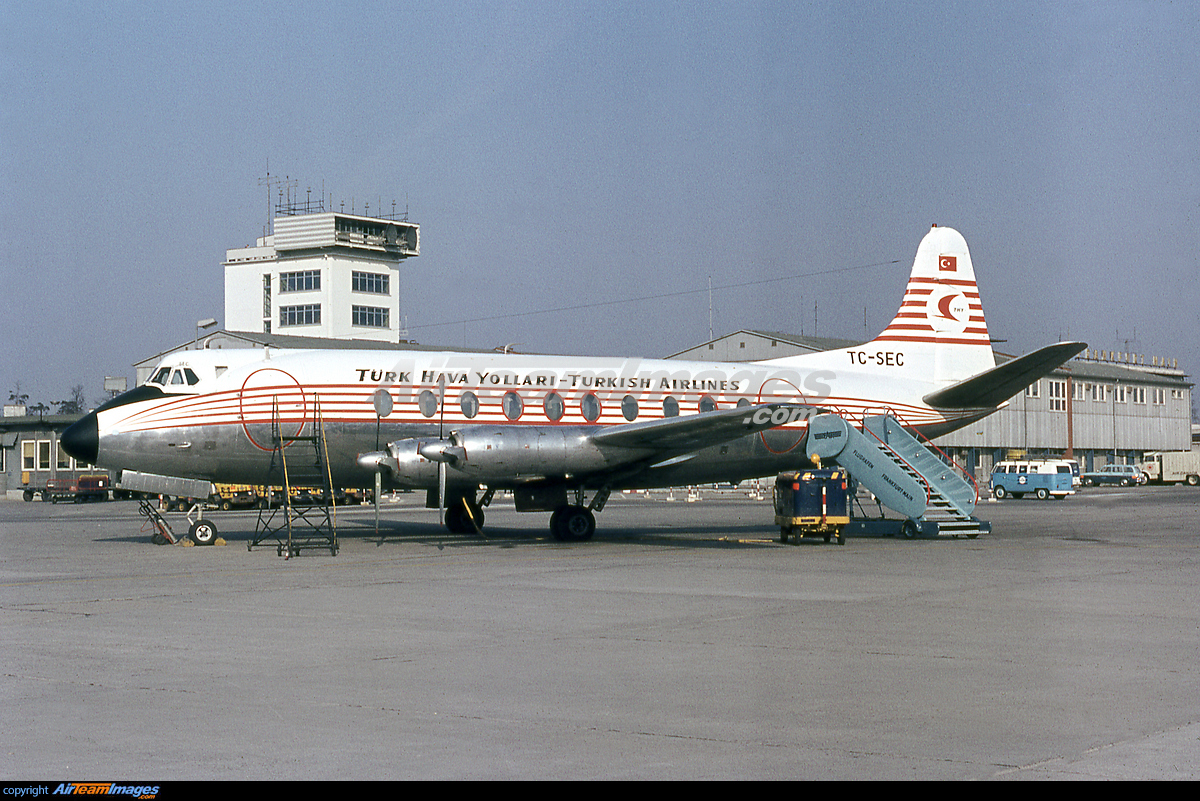
246 with Türk Hava Kuvvetleri in May 1978 at CGN:
www.planepictures.net/a/43/02/1136331882.jpg
Scan from Kodak slide.
Source Sculpture
Montreal, Quebec.
Jaume PLENSA
Born in Barcelona in 1955, Jaume Plensa lives and works in Barcelona and Paris. He studied at La Llotja (college of art and design) and the Royal Catalan Academy of Fine Arts of Saint George. Since 1980, when he had his first exhibition in Barcelona, he has lived and worked in Germany, Belgium, England, France, Japan, the United States, and Spain. He has had major solo shows in museums and sculpture parks. Among others, he was invited to present the work Together at the 56th Venice Biennale, in the nave of the San Giorgio Maggiore basilica. Many of his works are permanent works of public art, of which the best known is The Crown Fountain, installed in Millennium Park in Chicago in 2004.
Source is installed at the main entrance to downtown Montréal, in a landscaped terrace at the intersection of Boulevard Robert-Bourassa and Rue Wellington. The stainless-steel sculpture consists of a random intertwining of letters taken from Latin, Greek, Chinese, Arab, Cyrillic, Hindi, Hebrew, and Japanese alphabets, combined to form a monumental figure in a sitting position. The work is an allegory for humanity: like cells are assembled to form the human body, the letters form words, and people form a community. Source represents the wealth of cultures that Montréal has welcomed during its almost four centuries of existence. A symbol of the city’s past, present, and future, Source, seen in the light of day or under its night-time lighting, invites residents to walk, dream, and meet.
By creating Source for the 375th anniversary of the foundation of Montréal, the artist wanted to take into account the importance of water in the city’s history – for trade, immigration, and communications – but also the importance of the place of Indigenous peoples. Source, a word that is identical in French and English, refers to the birthplace of a watercourse, but also represents the roots of a city’s energy and vitality: its inhabitants and their origins, the fluidity and creativity of ideas, and the cycles of movement and renewal.
Associated events
Source was created within the context of the redevelopment project for the south threshold of the Bonaventure expressway, constituting a legacy for the 375th anniversary of the foundation of Montréal. The integration of Source into the Bonaventure legacy was made possible through an exceptional contribution by the Chrétien-Desmarais family.
Source: en.wikipedia.org/wiki/Monument_Valley
Monument Valley (Navajo: Tsé Biiʼ Ndzisgaii, pronounced [tsʰépìːʔ ǹtsɪ̀skɑ̀ìː], meaning "valley of the rocks") is a region of the Colorado Plateau characterized by a cluster of sandstone buttes, with the largest reaching 1,000 ft (300 m) above the valley floor. The most famous butte formations are located in northeastern Arizona along the Utah–Arizona state line. The valley is considered sacred by the Navajo Nation, the Native American people within whose reservation it lies.
Monument Valley has been featured in many forms of media since the 1930s. Famed director John Ford used the location for a number of his Westerns. Film critic Keith Phipps wrote that "its five square miles [13 km2] have defined what decades of moviegoers think of when they imagine the American West".
Sourc: navajonationparks.org/navajo-tribal-parks/monument-valley/
History
Before human existence, the Park was once a lowland basin. For hundreds of millions of years, materials that eroded from the early Rock Mountains deposited layer upon layer of sediment which cemented a slow and gentle uplift, generated by ceaseless pressure from below the surface, elevating these horizontal strata quite uniformly one to three miles above sea level. What was once a basin became a plateau.
Natural forces of wind and water that eroded the land spent the last 50 million years cutting into and peeling away at the surface of the plateau. The simple wearing down of altering layers of soft and hard rock slowly revealed the natural wonders of Monument Valley today.
From the visitor center, you see the world-famous panorama of the Mitten Buttes and Merrick Butte. You can also purchase guided tours from Navajo tour operators, who take you down into the valley in Jeeps for a narrated cruise through these mythical formations. Places such as Ear of the Wind and other landmarks can only be accessed via guided tours. During the summer months, the visitor center also features Haskenneini Restaurant, which specializes in both native Navajo and American cuisines, and a film/snack/souvenir shop. There are year-round restroom facilities. One mile before the center, numerous Navajo vendors sell arts, crafts, native food, and souvenirs at roadside stands.
Additional Foreign Language Tags:
(United States) "الولايات المتحدة" "Vereinigte Staaten" "アメリカ" "米国" "美国" "미국" "Estados Unidos" "États-Unis" "ארצות הברית" "संयुक्त राज्य" "США"
(Arizona) "أريزونا" "亚利桑那州" "אריזונה" "एरिजोना" "アリゾナ州" "애리조나" "Аризона"
(Utah) "يوتا" "犹他州" "יוטה" "यूटा" "ユタ州" "유타" "Юта"
(Monument Valley) "وادي النصب التذكاري" "纪念碑谷" "Vallée des monuments" "מוניומנט ואלי" "स्मारक घाटी" "モニュメントバレー" "모뉴먼트 밸리" "Долина Монументов" "Valle de los Monumentos"
Mon livre sur le Rajasthan / My last book upon the Rajasthan
Couleurs d'âmes by Photos Olivier Simard |
Pour vos séjours, for your trip in India: elephantravel.com/
Source: en.wikipedia.org/wiki/London
London is the capital and largest city of both England and the United Kingdom. Standing on the River Thames in the south-east of England, at the head of its 50-mile (80 km) estuary leading to the North Sea, London has been a major settlement for two millennia. Londinium was founded by the Romans. The City of London, London's ancient core − an area of just 1.12 square miles (2.9 km2) and colloquially known as the Square Mile − retains boundaries that follow closely its medieval limits. The City of Westminster is also an Inner London borough holding city status. Greater London is governed by the Mayor of London and the London Assembly.
London is considered to be one of the world's most important global cities and has been termed the world's most powerful, most desirable, most influential, most visited, most expensive, innovative, sustainable, most investment friendly, most popular for work, and the most vegetarian friendly city in the world. London exerts a considerable impact upon the arts, commerce, education, entertainment, fashion, finance, healthcare, media, professional services, research and development, tourism and transportation. London ranks 26 out of 300 major cities for economic performance. It is one of the largest financial centres and has either the fifth or sixth largest metropolitan area GDP. It is the most-visited city as measured by international arrivals and has the busiest city airport system as measured by passenger traffic. It is the leading investment destination, hosting more international retailers and ultra high-net-worth individuals than any other city. London's universities form the largest concentration of higher education institutes in Europe. In 2012, London became the first city to have hosted three modern Summer Olympic Games.
London has a diverse range of people and cultures, and more than 300 languages are spoken in the region. Its estimated mid-2016 municipal population (corresponding to Greater London) was 8,787,892, the most populous of any city in the European Union and accounting for 13.4% of the UK population. London's urban area is the second most populous in the EU, after Paris, with 9,787,426 inhabitants at the 2011 census. The population within the London commuter belt is the most populous in the EU with 14,040,163 inhabitants in 2016. London was the world's most populous city from c. 1831 to 1925.
London contains four World Heritage Sites: the Tower of London; Kew Gardens; the site comprising the Palace of Westminster, Westminster Abbey, and St Margaret's Church; and the historic settlement in Greenwich where the Royal Observatory, Greenwich defines the Prime Meridian, 0° longitude, and Greenwich Mean Time. Other landmarks include Buckingham Palace, the London Eye, Piccadilly Circus, St Paul's Cathedral, Tower Bridge, Trafalgar Square and The Shard. London has numerous museums, galleries, libraries and sporting events. These include the British Museum, National Gallery, Natural History Museum, Tate Modern, British Library and West End theatres. The London Underground is the oldest underground railway network in the world.
Source: en.wikipedia.org/wiki/London_Underground
The London Underground (also known simply as the Underground, or by its nickname the Tube) is a public rapid transit system serving London, England and some parts of the adjacent counties of Buckinghamshire, Essex and Hertfordshire in the United Kingdom.
The Underground has its origins in the Metropolitan Railway, the world's first underground passenger railway. Opened in January 1863, it is now part of the Circle, Hammersmith & City and Metropolitan lines; the first line to operate underground electric traction trains, the City & South London Railway in 1890, is now part of the Northern line. The network has expanded to 11 lines, and in 2017/18 carried 1.357 billion passengers, making it the world's 11th busiest metro system. The 11 lines collectively handle up to 5 million passengers a day.
The system's first tunnels were built just below the surface, using the cut-and-cover method; later, smaller, roughly circular tunnels—which gave rise to its nickname, the Tube—were dug through at a deeper level. The system has 270 stations and 250 miles (400 km) of track. Despite its name, only 45% of the system is underground in tunnels, with much of the network in the outer environs of London being on the surface. In addition, the Underground does not cover most southern parts of Greater London, with fewer than 10% of the stations located south of the River Thames.
The early tube lines, originally owned by several private companies, were brought together under the "UndergrounD" brand in the early 20th century and eventually merged along with the sub-surface lines and bus services in 1933 to form London Transport under the control of the London Passenger Transport Board (LPTB). The current operator, London Underground Limited (LUL), is a wholly owned subsidiary of Transport for London (TfL), the statutory corporation responsible for the transport network in Greater London. As of 2015, 92% of operational expenditure is covered by passenger fares. The Travelcard ticket was introduced in 1983 and Oyster, a contactless ticketing system, in 2003. Contactless card payments were introduced in 2014, the first public transport system in the world to do so.
The LPTB was a prominent patron of art and design, commissioning many new station buildings, posters and public artworks in a modernist style. The schematic Tube map, designed by Harry Beck in 1931, was voted a national design icon in 2006 and now includes other TfL transport systems such as the Docklands Light Railway, London Overground, Crossrail (which is officially called Elizabeth Line) and Tramlink. Other famous London Underground branding includes the roundel and Johnston typeface, created by Edward Johnston in 1916.
❤ SPONSORED by @ COSMOPOLITAN (Apr. 29th / May 11th) ❤
- Akalmad Island SOURCES
- Roots Bistro Set CHEZ MOI
- Flowery Arbour DUVET DAY
- Botanical Tower WARHORSE
❤❤ OTHERS ❤❤
Rock - FUNDATI
Wild Sunflowers - KONOHA
Source: en.wikipedia.org/wiki/Ludwigsburg
Ludwigsburg is a city in Baden-Württemberg, Germany, about 12 kilometres (7.5 mi) north of Stuttgart city centre, near the river Neckar. It is the largest and primary city of the Ludwigsburg district with about 88,000 inhabitants. It is situated within the Stuttgart Region, and the district is part of the administrative region (Regierungsbezirk) of Stuttgart.
Source: en.wikipedia.org/wiki/Ludwigsburg_Palace
Ludwigsburg Palace (Residenzschloss Ludwigsburg), also known as the "Versailles of Swabia", is a 452-room palace complex of 18 buildings located in Ludwigsburg, Baden-Württemberg, Germany. Its total area, including the gardens, is 32 ha (79 acres)—the largest palatial estate in the country. The palace has four wings: the northern wing, the Alter Hauptbau, is the oldest and was used as a ducal residence; the east and west wings were used for court purposes and housing guests and courtiers; the southern wing, the Neuer Hauptbau, was built to house more court functions and was later used as a residence.
Eberhard Louis, Duke of Württemberg, appointed Philipp Joseph Jenisch to direct the work and construction began in 1704. In 1707, Jenisch was replaced with Johann Friedrich Nette, who completed the majority of the palace and surrounding gardens. Nette died in 1714, and Donato Giuseppe Frisoni finished much of the palace facades. In the final year of construction, Eberhard Louis died and the Neue Hauptbau's interiors were left incomplete. Charles Eugene's court architect, Philippe de La Guêpière, completed and refurbished parts of the New Hauptbau in the Rococo style, especially the palace theatre. Charles Eugene abandoned the palace for Stuttgart in 1775. Duke Frederick II, later King Frederick I, began using Ludwigsburg as his summer residence in the last years of Charles Eugene's reign. Frederick and his wife Charlotte, Princess Royal, resided at Ludwigsburg and employed Nikolaus Friedrich von Thouret to renovate the palace in the Neoclassical style. Thouret converted much of Ludwigsburg's interiors over the reign of Frederick and later life of Charlotte. As a result of each architect's work, Ludwigsburg is a combination of Baroque, Rococo, Neoclassical, and Empire style architecture.
The constitutions of the Free People's State and Kingdom of Württemberg were ratified at Ludwigsburg Palace in 1919 and 1819, respectively. It was the residence for four of Württemberg's monarchs and some other members of the House of Württemberg and their families. The palace was opened to the public in 1918 and then survived World War II intact. It later underwent periods of restoration in the 1950s, 1960s, and 1990s and again for the palace's 300th anniversary in 2004. The palace had more than 350,000 visitors in 2017 and has hosted the Ludwigsburg Festival every year since 1947.
Surrounding the palace are the Blooming Baroque (Blühendes Barock) gardens, arranged in 1954 as they might have appeared in 1800. Nearby is Schloss Favorite, a hunting lodge built in 1717 by Frisoni. Within the palace are two museums operated by the Landesmuseum Württemberg dedicated to fashion and porcelain respectively.