View allAll Photos Tagged shivling
Tethered on the brink of Eternity...
On Rock Pillar at the start of the climb of The East Pillar of Shivling in the Garhwal Himal, Uttarakhand India
After night long blizzard, the morning was bright and the view was magnificent...
Taken from the Tapovan meadow at the base of Mount Shivling in Garhwal Himalayas, India
Bhrigupanth (6772mtrs) Catches some evening light as seen from Camp 2 on Shivling in the Garhwal Himal, Uttarakhand India
Glorious Mount Shivling shining in dawn light...taken from Gaumukh on trek to Tapovan in Garhwal Himalayas, india
Just before appearance sun creates a flaming backdrop to the Kinner peak and it's quite a spectacle! If you look closely you will clearly make out the Kinner Shivling standing out in the radiance!! The shivling, very pious to hindus, is Lord Shiva's incarnation. Pl see large
River Akashganga, the glacial stream at the base of the Mount Shivling was still frozen in the end of May, as taken on trek to Tapovan in Garhwal Himalayas, India
My best wishes to all of your for a bright Autumn !!
A lovely bunch of wild flowers...taken near the base of Mount Shivling on trek to Tapovan in Garhwal Himalayas, India
After a night long blizzard, the holy peak, Shivling (6,543 mts), bathes in the first light of a clear dawn.....part of Meru peak on the right side....10 years back, it was my first high altitude trek to the base camp....taken from Tapovan (the land of meditation) in Garhwal Himalayas, India
Remembering my old Kodak that travelled with me to so many places...here is one of its sunrise captures of Mount Meeu in May, 2007 on trek to Tapovan, the basecamp of Mount Shivling, in Garhwal Himalayas, India
Shivling forms the western gateway for the lower Gangotri Glacier, opposite the triple-peaked Bhagirathi massif. It lies on a spur projecting out from the main ridge that forms the southwest side of the Gangotri Glacier basin; this ridge contains other well-known peaks such as Bhagirathi, Thalay Sagar and Meru.
It was also called Mahadeo Ka Linga or (Mahadev Ka Linga) Appearing as a single pyramid when seen from Gaumukh, Shivling is actually a twin-summitted mountain, with the northeast summit being slightly higher than the southwest summit, 6,501 m (21,329 ft). Between Gaumukh and Shivling lies the Tapovan meadow, a popular pilgrimage site due to its inspiring view of the mountain.
Shivling is well-defended on all sides by steep rock faces; only the west flank has a moderate enough slope for snow accumulation.
Again to lay all my reverence at His feet....Holy Shivling.
Those unforgettable moments of mine to see Him bathing in first rays of dawn.
Taken from Tapovan in Garhwal Himalayas, India.
Myself in front of Goumukh, the snout of river Ganges (Ganga or to be precise, Bhagirathi), on trek to Tapovan, the basecamp of Mount Shivling….taken in Garhwal Himalayas, India
Sunny high mountain ridge where the pious shivling can be made out while the peak itself is hid behind clouds.
6543m. Sacred mountain in the Garhwal Himalaya of India.
Directly above Gaumukh, source of the Ganges River.
140mm, May 2017.
The morning emerges to lay its offerings before the Lord while the night draws out its dark veil; He showers on blessings upon both of His eternal companions...
Holy peak Shivling in Garhwal Himalayas, India.
Sunrise moments shared by the sacred peak Shivling and mount Meru....
Taken fromTapovan (Shivling Base camp) in Garhwal Himalayas, India
My first post on Flickr was on the 2nd August, 2007 and since then I have shared 925 public images on my page....through this long decade, I have received appreciation of so many friends and each of their words and favour have motivated me to make myself more focussed and dedicated to photography and also in enjoying it in lovelier manner...on celebrating the 10th year milestone, I share a frame captured in 2007 while I was on my trek to Tapovan, the base camp of Mount Shivling, in Garhwal Himalayas, India...I have just this single shot of Mount Shivling (on right) and Bhagirathi sisters (in series on the left) in a single frame...it was taken on one free-click digital camera from over Bhagirathi glacier (a glacier of 5 km width with much difficulty to negotiate for so many crevasses) while I was crossing it in early morning and was never shared before....enjoy !!!
Vaikathashtami, observed in the Malayalam month Vrishchikam on the eight day after full moon day, is one of the most popular temple festivals in Kerala. Vaikathashtami 2010 date is November 29. The festival is held at the famous Vaikom Mahadeva Temple at Vaikom near Kottayam in Kerala. Lord Shiva is worshipped here in the form of a Shivling, which is believed to have been formed during the Tretayuga.
The Vaikathashtami festival lasts for 12 days and the most important day is the Ashtami day. Ashtami is the eighth day after full moon and no moon as per traditional Hindu calendar.
The festival attracts thousands of people and one of the major highlights during the festival is the Ashtami Vilakku or lamps.
The feelings that I'd been blessed with can only be expressed by those amazing lines of Great Tagore...
Holy Shivling by Akashganga stream at Tapovan, Garhwal Himalayas, India.
The oval shape black is " shiva lingam" which indicates that in this universe every being, matter, celestial bodies are oval in shape. A Shiva Linga consists of three parts. The lowest of these is called the Brahma-Pitha; the middle one, the Vishnu-Pitha; the uppermost one, the Shiva-Pitha. These are associated with the Hindu pantheon of gods: Brahma (the Creator), Vishnu (the Preserver), and Shiva (the Destroyer).The shape of the milky way, solar system are all oval. The Lingam is shaped like an egg and represents the 'Brahmanda' or the cosmic egg.
lingam, in Hinduism, a votary object that symbolizes the god Shiva and is revered as an emblem of generative power. The lingam appears in Shaivite temples and in private shrines throughout India.
According to Hindu mythology women should not touch the Shivling, and everyone should stay away from non-veg food, onion, garlic and raw milk, etc, throughout Shravan Mass.
The Bhagirathi sisters shining in the first rays of the dawn.
Taken from above the Gangotri glacier en route Shivling basecamp (Tapovan meadow) in Garhwal Himalayas, India
The moon rising under the milky way in the Garhwal Himalaya, India. Self- Portrait.
Looking east from close to Gaumukh, the source of the Ganges River.
The Bhagirathi Towers (6856m) and Shivling (6543m) visible in the distance.
23 image panorama, 20 seconds, f/ 2.8, ISO 10 000.
This natural positioning of stone ... looked like a Shivling
Shot near Chandratal Lake in Spiti Valley
EXPLORED: 8th September 2016
this was clicked from Mt Shivling Base camp , the small river stream flowing also known as akash ganga , as its flowing from very high altitude . Evening here was magical..
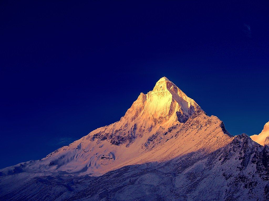
The summit pyramid of Bhrigupanth (6772m) juts out of the clouds to catch the lingering evening light as viewed from near Camp 2 on Shivling.
Bhrigupanth looks completely different from this side as compared to that when viewed from Kedar Taal.
Bhrigupanth's first ascent was made relatively late and it bears the distinction of having been first climbed by a Joint Indo- American Women's Team (led by Arlene Bloom) only in 1980
Straight off it's month voyage across the Pacific Ocean from you guessed it China, Yantian to be exact Maersk Shivling was able to skip the lines waiting to get in to Pier T since this 8K TEU is a bit smaller than all the 11-19Ks TTI usually gets. For a Maersk Ship this one is pretty bland looking (no markings etc.etc)
A different time of day, a new compo for a ridge of great importance.. For more details about the shivling pl see: www.flickr.com/photos/draskd/14873783522/in/photostream/
The trail to Gomukh begins from Gangotri, about 18 km (11.2 mi) from Gomukh. It was heavily damaged by rockslides by the 2013 North Indian Floods as was road access to Gangotri. 9 km ahead of Gangotri is Chirbasa, the abode of Chir trees. After 3 km of Chirbasa comes the dangerous Gila Pahar, the place well known for its landslides even prior to the 2013 destruction of much of the trail here; near-sheer cliffs down to the river must now be traversed. Here the Bharals, a type of mountain antelope are sometimes seen. The Bharals are found above the altitude of 10,000 ft. Only 4 km from here is Bhujbasa, the only night halting place on the way with buildings. One can stay at the GMVN Bunglow, or at the Lalbaba's Ashram or at Ram Baba's ashram; both ashram charge Rs 300 for a day that includes lodging and food. After trekking 41/2km from Bhujbasa, one reaches Gomukh, the snout of the Gangotri Glacier.A little before Gomukh, the majestic view of Mt. Shivling welcomes the trekkers to the place. On the trail no horses are allowed, so one must take preparations to walk on foot. The trek to Tapovanan and Nandanvan starts from here.
Snout point of Gongotri Glacier, Gomukh
The route after 'Bhujbasa' can be quite difficult, more so since the 2013 floods. One has to cross a boulder zone to reach the Gomukh snout. The trek beyond Gomukh is quite difficult. Crossing the glacier & going towards Tapovan has become quite dangerous nowadays (because of the landslides). There is no track and one must have a guide and should be prepared to face any type of accident which can even be a life-threatening one. The last climb to reach Tapovan is very stiff, within 2 km a climb of around 1500 foot and is quite a challenging experience.
I kept on pursuing the snowy trail which my sweet partner had trodden ahead.
Together we walked till we truly felt the essence of being together !
That was the holiest moment of our life !
That glorious face of Mt. Shivling shined bright during the morning hours. Remarkably the face resembles quite closely to God Ganesh.
What incredible tattoos ! The ten heads of Ravan, the king of Lanka on his shoulders and down his arms and the sacred Shivling on. his back. The back took 25 days to complete. A work of art !
With my heartfelt thanks to everyone in Flickr.....
This is my first anniversary in Flickr....
Here are those featured on Explore during the last year...
1. Subliminal presence of viruality within reality !, 2. Enamoured by her own reflections !, 3. How green is my sweet homeland !, 4. The sacred Lake Parasar, 5. The warmth of peace in the cold desert !, 6. Evening etherized !, 7. An elegant romance !, 8. Blushed in last kisses of the Sun !,
9. Nature, 10. To bee, or not to bee; the Spring has its offerings !, 11. Warmth in wilderness !, 12. Miles to go...., 13. Mount Neelkantha !, 14. Scarlet and white !, 15. The last show !, 16. Renewing an endless voyage...,
17. My eyes have vision only for you !, 18. Expressions !, 19. All quiet on the western front !, 20. Tenderness !!, 21. A bird's eye view, 22. A golden alleyway, 23. Submission !, 24. A fading memory !,
25. Love !!!, 26. The last ride together !, 27. Dreamland !, 28. I wandered lonely as a cloud......, 29. Jogin sisters, 30. Peace has its victory !, 31. A Turquoise on Himalayan crown !, 32. Where the head is held high,
33. The united generations, 34. A burning sensation !, 35. Molten gold !, 36. Chandratal (the Moon lake), 37. Meru and Shivling
Shivling peak above the Gangotri Glacier in the Himalayas. The Gangotri glacier (gaumukh) is one of the sources of the Ganga river.
Name: Shivling
Location: Garhwal Himalayas, Uttaranchal, India
Altitude: 6,543 meters
Camera: Nikon FM10
Shot taken at early morning from half way up the glacier. During this time of the year June/July/August the mountains are covered by clouds. I had to wake up early and start climbing the glacier in low light to get this shot. Picture shows clouds coming in and covering the mountain.
Kalpa is a small town in the Sutlej river valley, above Recong Peo in the Kinnaur district of Himachal Pradesh, India. Kalpa is one of the biggest and beautiful village of Kinnaur district. Inhabited by Kinnauri people and famous for its apple orchards. Kalpa is at an average elevation of 2,960 metres (9,711 feet). It is located 265 kilometres (165 mi) beyond Shimla and located at the base of the Kinnaur Kailash snow-capped ranges. The Shivling peaks rise up to 20,000 feet (6,000 m). In winter all the villages are covered by about 5–7 feet of snow, and the temperature can drop to as low as -20 °C, heavy woolens are required even most of time in summer.
shivling bathing in early morning light, peeping from behind the huge foreground range still devoid of morning light.
see my other image with mystic feel @ www.flickr.com/search/?s=int&w=43109416@N00&q=mys...
This is what I had envisioned before I started for this journey to Tapovan - to be able to capture such a juxtaposition of milky way galaxy above Mt.Shivling. I was awarded with this image by the almighty. Isn't that a sight to savor?
Shot from Kalpa across Sutlej river, Himachal Pradesh. The average height of these subsidiary peaks of Mt Kinner Kailash is 16-17 thousand feet and the rocky outcrop on the peak near the centre of this frame is the shivling and very pious for hindus.The shivling is 72 ft high.
On the foot of Mt. Shivling is Tapovana, one of the most holiest sites for thousands of years where the Sages performed austerities. The spiritual dominance of this location has lured in people from every part of India. Blessed to have witnessed its full glory _/\_