View allAll Photos Tagged sfpl
(railing abuts alice aycock 2-story sculpture)
San Francisco Public Library
Civic Center
San Francisco, California
Opened April 18th, 1996 (the 90th anniversary of the SF earthquake), architects Pei Cobb Freed and Partners.
“The new main” library building opened on April 18th, 1996, on the 90th anniversary of the famous San Francisco earthquake.
The San Francisco Public Library, building opened April 18, 1996 (the 90th anniversary of the 1906 earthquake and fire). Architects: Pei Cobb Freed and Partners.
This building opened on April 18th, 1996, the 90th anniversary of the great earthquake and fire. Architects James Ingo Freed and Cathy Simon. Next month is the 25th anniversary of the building’s opening.
The Golden Gate Valley branch of the San Francisco Public Library, built 1917-1918, opened May 5, 1918. The building was built with funds from Andrew Carnegie (“a Carnegie Library”). Architect: Ernest Coxhead.
A San Francisco Public Library patron takes a mid-day nap at the Main Branch. San Francisco, CA.
The San Francisco Public Library's Main Branch is one of the city's best used resources. Sandwiched between The Tenderloin and SOMA neighborhoods, it's massive structure climbs up six stories and spans over one city block. The Main Branch is a dynamic building filled with funky people and offbeat activities, for better or worse.
www.jasonogulnik.com/blah-blah-blog/2014/6/12/2dvkn4l8lqn...
The building opened on April 18th, 1996, the 90th anniversary of the great San Francisco Earthquake and Fire.
Original Size (5332 x 3986, 7.7 MB)
Here is a Commercial Atlas Street Map of San Francisco from 1925. Many of the differences between this map and current day are listed in Octoferret's 1938 Standard Oil San Francisco Street Map with the most notable difference being that in 1925 neither the Golden Gate or the Bay Bridge had been built. A couple of other differences with the 1938 map are the lack of Fleishhacker Pool (opened 1925), Kezar Stadium (opened 1925), and Seal's Stadium (opened 1931). In the 1925 map there were still significant cemeteries between the Presidio and the Panhandle, about half of which had been consumed by USF by 1938.
One natural feature to note is the creek running from south of Balboa Park to south of Bernal Heights. Although it is identified as Island creek, I believe this is one of the branches of Islais creek. The other branch ran up through Glen canyon. This branch was mostly forced into storm drains in the late 1920s to allow construction of Alemany Blvd. Speaking of Balboa Park, this map notes that it was formerly the The House of Refuge Lot
This map has a lot of detailed information about transportation infrastructure, including railroad and streetcar lines. This map shows the Roundhouse at Mariposa and Minnesota in the south end of the Southern Pacific yards at Mission Bay. It also shows the tunnel under Potrero Hill from 18th and Wisconsin to 22nd and Texas. In 1962 they were forced to fill the tunnel in because fire and cave-ins were causing sink-holes on the streets above. The map also shows the right-of-way across the Mission District from 22nd and Harrison to San Jose and Randall. From there the right-of-way becomes the path of 280.
Many of the streets depicted here did not exist, reflecting planned streets in undeveloped parts of the city. This is particularly notable in the Southeast corner of the map which anticipates the almost complete landfill reclamation and development of the South Basin between Hunter's Point and Candlestick Point. I'm not sure if this is correct, but it also looks like they were anticipating the China Basin Water Channel to be filled in as well. Other undeveloped/partially developed areas which eventually had different street layouts include the Marina (with an unnamed road north of Marina Blvd shown), Diamond Heights/Mount Davidson, and the southern Sunset, where Pine Lake and Stern Grove are omitted and McCoppin Square and Vicente Square are listed only as "Public Square".
In the greater Bay Area map in the upper right corner Yerba Buena Island is labeled Goat Island.
Doug Schaden, a 3rd floor page at the San Francisco Public Library's Main Branch, gathers discarded books to be re shelved. San Francisco, CA.
The San Francisco Public Library's Main Branch is one of the city's best used resources. Sandwiched between The Tenderloin and SOMA neighborhoods, it's massive structure climbs up six stories and spans over one city block. The Main Branch is a dynamic building filled with funky people and offbeat activities, for better or worse.
www.jasonogulnik.com/blah-blah-blog/2014/6/12/2dvkn4l8lqn...
At San Francisco Public.. HBM! I think the warm vs cool light is one of the things that makes this picture work. What’s your opinion?
After our rehearsals were over, Rob, Steve, Allen, and I headed out to capture some of Singapore at night. This huge ferris wheel is very similar to the London Eye and I think it was put in to pull tourists to another area of the city. Actually, I have no idea why its there. We never went on it as we were too busy snapping away.
Off to China in the AM to 2 days...More about it on the blog at www.mdsimages.blogspot.com
Sitting at Customs after arriving from LGW in a snow storm. I nearly achieved frost bite in my ears and hands for this one.
from the SFPL exhibit "Screaming Queens: The Riot at Compton’s Cafeteria"
Accompanying card reads "Lousie Lawrence, a biological male who lived as a woman, began organizing San Francisco's transgender community in the 1940's."
Read more about Louise Lawrence here
zagria.blogspot.com/2009/05/louise-lawrence-1912-1976-act...
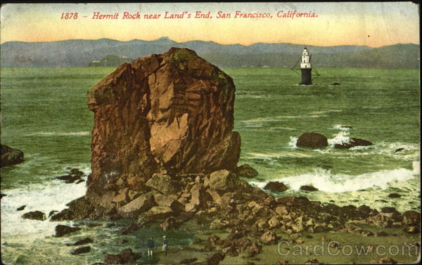
with rock names
here sflib1.sfpl.org:82/record=b1014070 and here www.cardcow.com/images/set262/card00343_fr.jpg
FUN & FROLIC on EASTER SUNDAY with the SISTERS OF PERPETUAL INDULGENCE in DOLORES PARK, SAN FRANCISCO!
30 YEARS OF PERPETUAL INDULGENCE was celebrated with the annual HUNKY JESUS CONTEST (BROKEBACK MOUNTAIN JESUS won with the winning cry "I CAN'T QUIT YOU JESUS!"
The SISTERS world is being celebrated with a display at the JAMES C. HORMEL GAY & LESBIAN CENTER at the 3rd floor of the MAIN LIBRARY www.sfpl.org
...and a show at YERBA BUENA CENTER FOR THE ARTS, at 701 Misssion Streets. www.ybca.org
Click here for further information or a high resolution copy of this image.
Rights: Permission to use this image commercially must be obtained from the San Francisco History Center, San Francisco Public Library. www.sfpl.org/permissions When using this image please credit SAN FRANCISCO HISTORY CENTER, SAN FRANCISCO PUBLIC LIBRARY.