Interior Redesign
View allAll Photos Tagged redesign
Featured Sponsors:
Garmonbozia @ Warehouse Sale
Kiona @ eBENTO Event
Full Details @ rainbowpixiefarts.blogspot.com/2022/01/redesign-1212.html
1955 Cadillac Eldorado
Dagmar bumpers (also known as "bullet bumpers") is a slang term for chrome conical-shaped bumper guards that began to appear on the front bumper/grille assemblies of certain American automobiles following World War II. They reached their peak in the mid-1950s.
The term evokes the prominent bosom of Dagmar, a buxom early-1950s television personality featuring low-cut gowns and conical bra cups. She was amused by the tribute.
As originally conceived by Harley Earl, GM Vice President of Design, the conical bumper guards would mimic artillery shells. Placed inboard of the headlights on front bumpers of Cadillacs, they were intended to both convey the image of a speeding projectile and protect vehicles' front ends in collisions. The similarity of these features to the then popular bullet bra as epitomized by buxom television personality Dagmar was inescapable.
As the 1950s wore on and American automakers' use of chrome grew more flamboyant, they grew more pronounced. The black rubber tips they gained on the 1957 Cadillac Eldorado Brougham and other models were known as pasties.
Postwar Cadillacs began sporting conical bumper guards in the 1946 model year. In 1951 models, some were raised into the grille. In 1957, black rubber tips appeared. The element continued to become more pronounced in size through 1958, but were eliminated in the 1959 Cadillac redesign.
Mercury sported Dagmars in 1953 through the 1956 model year. Lincoln added Dagmars in 1960, with a black rubber ring separating the body from the chrome tip.
Buick added Dagmars on its 1954 and 1955 models, in 1954 as part of the bumper assembly, and moved into the grille in 1955.
Packard included large Dagmars on the bumper in 1955 and 1956 models.
Full-sized Chevys in 1961 and 1963 also had small rubber Dagmars on the front bumper, and 1962 Ford Galaxie had small rubber Dagmars as an option.
The Plaza de España, designed by Aníbal González, was a principal building built on the Maria Luisa Park's edge to showcase Spain's industry and technology exhibits. González combined a mix of 1920s Art Deco and Spanish Renaissance Revival, Spanish Baroque Revival and Neo-Mudéjar styles. The Plaza de España complex is a huge half-circle; the buildings are accessible by four bridges over the moat, which represent the ancient kingdoms of Spain. In the centre is the Vicente Traver fountain.
Many tiled alcoves were built around the plaza, each representing a different province of Spain. The Plaza's tiled Alcoves of the Provinces are frequent backdrops for visitors' portrait photographs, taken in their own home province. Each alcove is flanked by a pair of covered bookshelves, now used by visitors in the manner of a; Little Free Library. Each bookshelf often contains works with information about their province. Visitors have also donated favorite novels and other books for others to read.
Today the buildings of the Plaza de España have been renovated and adapted for use as offices for government agencies. The central government departments, with sensitive adaptive redesign, are located within it. Toward the end of the park, the grandest mansions from the fair have been adapted as museums. The most distant museum contains the city's archaeology collections. The main exhibits are Roman mosaics and artefacts from nearby Italica.
The Plaza de España has been used as a filming location, including scenes for Lawrence of Arabia (1962). The building was used as a location in the Star Wars movie series Star Wars: Episode II – Attack of the Clones (2002) — in which it featured in exterior shots of the City of Theed on the Planet Naboo. It also featured in the 2012 film The Dictator. The 2023 Netflix series, Kaos, also featured scenes filmed at the Plaza.
my shop has been a little quiet and this is why! I decided it's time for fresher, cleaner graphics for Cloud 9! took me a while to put this together but I'm happy with the results. thanks for all the support for my silly little doodles ♡
'LF' Spitfires had engine superchargers optimized for low level flight and it was found that removing the wing tips (which could easily be done in the field) allowed a faster role rate at those lower altitudes. Confusingly, not all LF Spitfires flew with 'clipped' wings, and not all clipped wing Spitfires are LF models. A captured FW-190 was found to outperform the then current Mk V Spitfire in most important repects which led to the hasty redesign of Mk Vs to MK IXs with a more powerful engine which went some way to addressing the deficit.
423 364 und ein unbekannter weiterer 423 am Einfahrvorsignal des Bahnhofs Aying. (S6554 Erding - Kreuzstraße)
The redesign of the Delft train station started in 1999. The project's goal was to move the two tracks underground in order to reduce noise pollution in the tiny, quaint city centre. In 2015 the new station building opened and trains ran successfully through the new tunnels. By 2020, they aim to have the old infrastructure (platforms and viaduct) removed.
Deconstruction of the old platforms is underway. I shunted a barrier aside to take this.
Zehn von noch zwanzig Tw der Reihe 2200 der CFL erhalten bis 2025 eine innere und äußere Aufarbeitung. Angelehnt ist die Neulackierung an die künftige Optik der bereits bestellten Alstom Coradia Stream. Der 2201, als einer der ersten fertiggestellten Einheiten, überfährt hier den „Viadukt Clausen“ als 3618 von Luxemburg-Gare nach Diekirch. Wobei die Zugnummer etwas an die E-Lok Reihe 3600 erinnert, die Jahrzehnte bei der CFL in Dienst standen.
CFL 2200 in redesign
Ten of the twenty remaining Tws in the CFL's 2200 series will receive an internal and external refurbishment by 2025. The repainting is based on the look of the Alstom Coradia Stream that has already been ordered. The 2201, one of the four units completed to date, crosses the “Clausen Viaduct” as the 3618 from Luxemburg-Gare to Diekirch.
Assembling everything good or bad prior to mapping out the forthcoming new Erskine Design website. Hoping to relaunch in the next month or so.
Click image and then "All Sizes" to view "transparent" GIF..
"Whenever something is wrong, something is too big." --- Leopold Kohr
The USA has gotten too big - the solution - divide it into more cohesive nations - Pacifica, Redneckistan, and the New American Republic.
Frisch von der Karte:
Heute morgen las ich eine Sichtung, dass der modernisierte Vias Flirt auf Linie fährt. Grob überschlug ich die Zeit, fuhr zum Bahnhof Frankfurt Höchst und durfte dank zwei netten Mitarbeitern von InfraGo auf den alten Bahnsteig.
Zum Zug: Das Außendesign verspricht viel, aber beim Reingehen kommt die blanke Enttäuschung: Lediglich die Türen wurden umlackiert, die Druckknöpfe erneuert, neue Echtzeit Monitore verbaut und die "SE 10" Aufkleber wurden nach Jahren durch neue ersetzt. Das wars eigentlich schon. Also ich hätte mehr erwartet...
Wie gesagt, alle Vias Flirts sollen jetzt dieses "Upedate" bekommen, wenn alle Züge aber so lange wie der erste brauchen, ist der Verkehrsvertrag schon vorbei 😅
A redesign of one of my older console room designs. flic.kr/p/2iMdkQP
I used the larger wall elements I made for the fright knights console room and completely redesigned the console.
It's been a long time coming. But I think she's finally ready.
For ages I had been trying to build a version of the Duchess that could seat two minifigures. I originally had used the cab piece that was commonly used for cars in the Adventurers theme. But it didn't look right due to the lack of the part coming in dark green.
After much tinkering I came up with a good design that looked ideal.
Funnily enough the entire design is a massive redesign. The entire bonnet section is a new construction, along with the chassis. The rear even has storage space for a few items.
And of course the cockpit is nicely detailed too.
Die E10 hat am Abend des 30.10.2021 zur "Goldenen Blauen Stunde" mit ihrem Zug St. Pölten Hauptbahnhof erreicht.
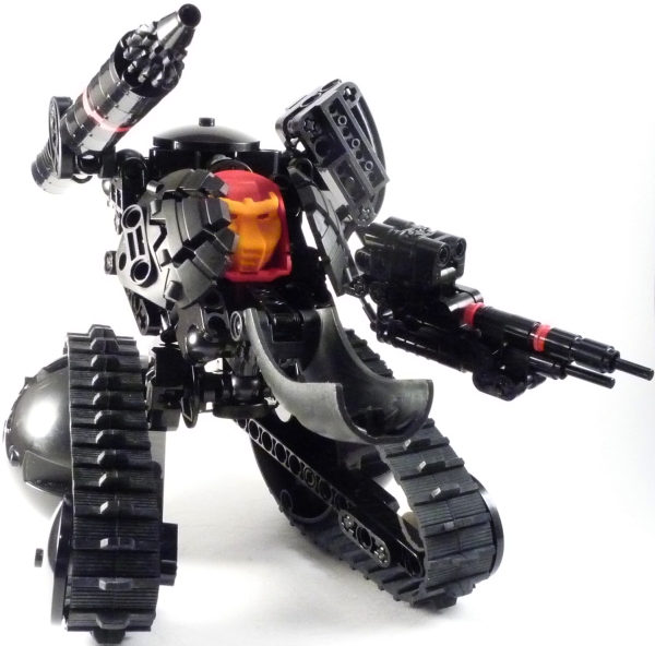
Wasn't happy with the design of the hull or suspension of the tank. New turret for the Turan Mk. III is underway
After doing some shopping at the fantasy faire, I decided to update Dawn!
Using Soul's Gyouko Ceredil, Gauze and Trap's Hooves and Zeva Horns, Trap and Illusions Pierced Gelf Ears, Cole's Corner's awesome auras, Magika's Please Hair, Fallen God's AGARWAEN face tattoo, Devae. Lupine Eyes, Aii's Bento Devil Tail, and Catwa Head. Whew!
"if you haven't found it yet, keep looking. don't settle. as with all matters of the heart, you'll know when you find it. and, like any great relationship, it just gets better and better as the years roll on." - Steve Jobs.
"R.I.P. Steve Jobs. I bet you're busy right now revolutionizing and redesigning the afterlife for all of us to enjoy when our time comes..." (Joe Satriani, 2011)
love stuff you see here? check out my page for more photos - FACEBOOK
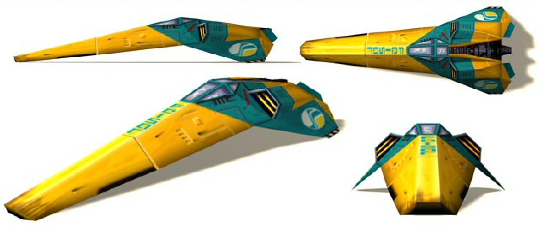
I like the design of the Resistance Bomber from Episode 8 but I (as well as many others) felt that it wasn't really practical.
So I tried to modify the design to make it a better suited craft for the resistance or rebel fleet.
The fuselage remains the same but is downscaled considerably. The Bomber is outfittet with more powerful engines (for it's size) and comes with a powerful missle launcher. Maneuverability is also enhanced due to a large stabilizer wing in the front. The crew consists of a pilot, a copilot/gunner and an engineer.
Thessaloniki (Greek: Θεσσαλονίκη, often referred to internationally as Thessalonica or Salonica, is the second-largest city in Greece and the capital of the Greek region of Macedonia, the administrative region of Central Macedonia and the Decentralized Administration of Macedonia and Thrace.[3][4] Its honorific title is Συμπρωτεύουσα (Symprotévousa), literally "co-capital",[5] and stands as a reference to its historical status as the Συμβασιλεύουσα (Symvasilévousa) or "co-reigning" city of the Eastern Roman (Byzantine) Empire, alongside Constantinople.[6]
According to the preliminary results of the 2011 census, the municipality of Thessaloniki today has a population of 322,240,[1] while the Thessaloniki Urban Area (the contiguous built up area forming the "City of Thessaloniki") has a population of 790,824.[1] Furthermore, the Thessaloniki Metropolitan Area extends over an area of 1,455.62 km2 (562.02 sq mi) and its population in 2011 reached a total of 1,104,460 inhabitants.[1]
Thessaloniki is Greece's second major economic, industrial, commercial and political centre, and a major transportation hub for the rest of southeastern Europe;[7] its commercial port is also of great importance for Greece and the southeastern European hinterland.[7] The city is renowned for its festivals, events and vibrant cultural life in general,[8] and is considered to be Greece's cultural capital.[8] Events such as the Thessaloniki International Trade Fair and the Thessaloniki International Film Festival are held annually, while the city also hosts the largest bi-annual meeting of the Greek diaspora.[9] Thessaloniki is the 2014 European Youth Capital.[10]
Founded in 315 BC by Cassander of Macedon, Thessaloniki's history spans some 2,300 years. An important metropolis by the Roman period, Thessaloniki was the second largest and wealthiest city of the Byzantine Empire. Thessaloniki is home to numerous notable Byzantine monuments, including the Paleochristian and Byzantine monuments of Thessaloniki, a UNESCO World Heritage Site, as well as several Roman, Ottoman and Sephardic Jewish structures. The city's main university, Aristotle University, is the largest in Greece and the Balkans.[11]
Thessaloniki is a popular tourist destination in Greece. In 2010, Lonely Planet ranked Thessaloniki as the world's fifth-best party city worldwide, comparable to other cities such as Dubai and Montreal.[12] For 2013 National Geographic Magazine included Thessaloniki in its top tourist destinations worldwide,[13] while in 2014 Financial Times FDI magazine (Foreign Direct Investments) declared Thessaloniki as the best mid-sized European city of the future for human capital and lifestyle.
Etymology
All variations of the city's name derive from the original (and current) appellation in Greek: Θεσσαλονίκη (from Θεσσαλός, Thessalos, and Νίκη, Nike), literally translating to "Thessalian Victory". The name of the city came from the name of a princess, Thessalonike of Macedon, half sister of Alexander the Great, so named because of her birth on the day of the Macedonian victory at the Battle of Crocus Field (353/352 BCE).[16]
The alternative name Salonica (or Salonika) derives from the variant form Σαλονίκη (Saloníki) in popular Greek speech, and has given rise to the form of the city's name in several languages. Names in other languages prominent in the city's history include Солѹнь (Solun) in Old Church Slavonic, סלוניקה (Salonika) in Ladino, Selanik (also Selânik) in Turkish (سلانیك in Ottoman Turkish), Solun (also written as Солун) in the local and neighboring South Slavic languages, Салоники (Saloníki) in Russian, and Sãrunã in Aromanian. In local speech, the city's name is typically pronounced with a dark and deep L characteristic of Macedonian Greek accent.[17][18]
The name often appears in writing in the abbreviated form Θεσ/νίκη
History
From antiquity to the Roman Empire
The city was founded around 315 BC by the King Cassander of Macedon, on or near the site of the ancient town of Therma and 26 other local villages.[20] He named it after his wife Thessalonike,[21] a half-sister of Alexander the Great and princess of Macedon as daughter of Philip II. Under the kingdom of Macedon the city retained its own autonomy and parliament[22] and evolved to become the most important city in Macedon.[21]
After the fall of the kingdom of Macedon in 168 BC, Thessalonica became a free city of the Roman Republic under Mark Antony in 41 BC.[21][23] It grew to be an important trade-hub located on the Via Egnatia,[24] the road connecting Dyrrhachium with Byzantium,[25] which facilitated trade between Thessaloniki and great centers of commerce such as Rome and Byzantium.[26] Thessaloniki also lay at the southern end of the main north-south route through the Balkans along the valleys of the Morava and Axios river valleys, thereby linking the Balkans with the rest of Greece.[27] The city later became the capital of one of the four Roman districts of Macedonia.[24] Later it became the capital of all the Greek provinces of the Roman Empire due to the city's importance in the Balkan peninsula. When the Roman Empire was divided into the tetrarchy, Thessaloniki became the administrative capital of one of the four portions of the Empire under Galerius Maximianus Caesar,[28][29] where Galerius commissioned an imperial palace, a new hippodrome, a triumphal arch and a mausoleum among others.[29][30][31]
In 379 when the Roman Prefecture of Illyricum was divided between the East and West Roman Empires, Thessaloniki became the capital of the new Prefecture of Illyricum.[24] In 390 Gothic troops under the Roman Emperor Theodosius I, led a massacre against the inhabitants of Thessalonica, who had risen in revolt against the Germanic soldiers. With the Fall of Rome in 476, Thessaloniki became the second-largest city of the Eastern Roman Empire.[26] Around the time of the Roman Empire Thessaloniki was also an important center for the spread of Christianity; some scholars hold that the First Epistle to the Thessalonians written by Paul the Apostle is the first written book of the New Testament.
Byzantine era and Middle Ages
From the first years of the Byzantine Empire, Thessaloniki was considered the second city in the Empire after Constantinople,[33][34][35] both in terms of wealth and size.[33] with an population of 150,000 in the mid 1100s.[36] The city held this status until it was transferred to Venice in 1423. In the 14th century the city's population exceeded 100,000 to 150,000,[37][38][39] making it larger than London at the time.[40]
During the 6th and 7th centuries the area around Thessaloniki was invaded by Avars and Slavs, who unsuccessfully laid siege to the city several times.[41] Traditional historiography stipulates that many Slavs settled in the hinterland of Thessaloniki,[42] however, this migration was allegedly on a much smaller scale than previously thought.[42][42][43] In the 9th century, the Byzantine Greek missionaries Cyril and Methodius, both natives of the city, created the first literary language of the Slavs, the Glagolic alphabet, most likely based on the Slavic dialect used in the hinterland of their hometown.[44][45][46][47][48]
An Arab naval attack in 904 resulted in the sack of the city.[49] The economic expansion of the city continued through the 12th century as the rule of the Komnenoi emperors expanded Byzantine control to the north. Thessaloniki passed out of Byzantine hands in 1204,[50] when Constantinople was captured by the forces of the Fourth Crusade and incorporated the city and its surrounding territories in the Kingdom of Thessalonica[51] — which then became the largest vassal of the Latin Empire. In 1224, the Kingdom of Thessalonica was overrun by the Despotate of Epirus, a remnant of the former Byzantine Empire, under Theodore Komnenos Doukas who crowned himself Emperor,[52] and the city became the Despotat's capital.[52][53] This era of the Despotate of Epirus is also known as the Empire of Thessalonica.[52][54][55] Following his defeat at Klokotnitsa however in 1230,[52][54] the Empire of Thessalonica became a vassal state of the Second Bulgarian Empire until it was recovered again in 1246, this time by the Nicaean Empire.[52] In 1342,[56] the city saw the rise of the Commune of the Zealots, an anti-aristocratic party formed of sailors and the poor,[57] which is nowadays described as social-revolutionary.[56] The city was practically independent of the rest of the Empire,[56][57][58] as it had its own government, a form of republic.[56] The zealot movement was overthrown in 1350 and the city was reunited with the rest of the Empire.[56]
In 1423, Despot Andronicus, who was in charge of the city, ceded it to the Republic of Venice with the hope that it could be protected from the Ottomans who were besieging the city (there is no evidence to support the oft-repeated story that he sold the city to them). The Venetians held Thessaloniki until it was captured by the Ottoman Sultan Murad II on 29 March 1430.
Ottoman period
When Sultan Murad II captured Thessaloniki and sacked it in 1430, contemporary reports estimated that about one-fifth of the city's population was enslaved.[60] Upon the conquest of Thessaloniki, some of its inhabitants escaped,[61] including intellectuals such as Theodorus Gaza "Thessalonicensis" and Andronicus Callistus.[62] However, the change of sovereignty from the Byzantine Empire to the Ottoman one did not affect the city's prestige as a major imperial city and trading hub.[63][64] Thessaloniki and Smyrna, although smaller in size than Constantinople, were the Ottoman Empire's most important trading hubs.[63] Thessaloniki's importance was mostly in the field of shipping,[63] but also in manufacturing,[64] while most of the city's trade was controlled by ethnic Greeks.[63]
During the Ottoman period, the city's population of mainly Greek Jews and Ottoman Muslims (including those of Turkish and Albanian, as well as Bulgarian Muslim and Greek Muslim convert origin) grew substantially. By 1478 Selânik (سلانیك), as the city came to be known in Ottoman Turkish, had a population of 4,320 Muslims, 6,094 Greek Orthodox and some Catholics, but no Jews. Soon after the turn of the 15th to 16th century, nearly 20,000 Sephardic Jews had immigrated to Greece from Spain following their expulsion by the 1492 Alhambra Decree.[65] By c. 1500, the numbers had grown to 7,986 Greeks, 8,575 Muslims, and 3,770 Jews. By 1519, Sephardic Jews numbered 15,715, 54% of the city's population. Some historians consider the Ottoman regime's invitation to Jewish settlement was a strategy to prevent the ethnic Greek population (Eastern Orthodox Christians) from dominating the city.[38]
Thessaloniki was the capital of the Sanjak of Selanik within the wider Rumeli Eyalet (Balkans)[66] until 1826, and subsequently the capital of Selanik Eyalet (after 1867, the Selanik Vilayet).[67][68] This consisted of the sanjaks of Selanik, Serres and Drama between 1826 and 1912.[69] Thessaloniki was also a Janissary stronghold where novice Janissaries were trained. In June 1826, regular Ottoman soldiers attacked and destroyed the Janissary base in Thessaloniki while also killing over 10,000 Janissaries, an event known as The Auspicious Incident in Ottoman history.[70] From 1870, driven by economic growth, the city's population expanded by 70%, reaching 135,000 in 1917.[71]
The last few decades of Ottoman control over the city were an era of revival, particularly in terms of the city's infrastructure. It was at that time that the Ottoman administration of the city acquired an "official" face with the creation of the Command Post[72] while a number of new public buildings were built in the eclectic style in order to project the European face both of Thessaloniki and the Ottoman Empire.[72][73] The city walls were torn down between 1869 and 1889,[74] efforts for a planned expansion of the city are evident as early as 1879,[75] the first tram service started in 1888[76] and the city streets were illuminated with electric lamp posts in 1908.[77] In 1888 Thessaloniki was connected to Central Europe via rail through Belgrade, Monastir in 1893 and Constantinople in 1896.
Since the 20th century
In the early 20th century, Thessaloniki was in the center of radical activities by various groups; the Bulgarian Internal Macedonian Revolutionary Organization, founded in 1897,[78] and the Greek Macedonian Committee, founded in 1903.[79] In 1903 an anarchist group known as the Boatmen of Thessaloniki planted bombs in several buildings in Thessaloniki, including the Ottoman Bank, with some assistance from the IMRO. The Greek consulate in Ottoman Thessaloniki (now the Museum of the Macedonian Struggle) served as the center of operations for the Greek guerillas. In 1908 the Young Turks movement broke out in the city, sparking the Young Turk Revolution.[80]
The Ottoman Feth-i Bülend being sunk in Thessaloniki in 1912 by a Greek ship during the First Balkan War.
Constantine I of Greece with George I of Greece and the Greek army enter the city.
As the First Balkan War broke out, Greece declared war on the Ottoman Empire and expanded its borders. When Eleftherios Venizelos, Prime Minister at the time, was asked if the Greek army should move towards Thessaloniki or Monastir (now Bitola, Republic of Macedonia), Venizelos replied "Salonique à tout prix!" (Thessaloniki, at all costs!).[81] As both Greece and Bulgaria wanted Thessaloniki, the Ottoman garrison of the city entered negotiations with both armies.[82] On 8 November 1912 (26 October Old Style), the feast day of the city's patron saint, Saint Demetrius, the Greek Army accepted the surrender of the Ottoman garrison at Thessaloniki.[83] The Bulgarian army arrived one day after the surrender of the city to Greece and Tahsin Pasha, ruler of the city, told the Bulgarian officials that "I have only one Thessaloniki, which I have surrendered".[82] After the Second Balkan War, Thessaloniki and the rest of the Greek portion of Macedonia were officially annexed to Greece by the Treaty of Bucharest in 1913.[84] On 18 March 1913 George I of Greece was assassinated in the city by Alexandros Schinas.[85]
In 1915, during World War I, a large Allied expeditionary force established a base at Thessaloniki for operations against pro-German Bulgaria.[86] This culminated in the establishment of the Macedonian Front, also known as the Salonika Front.[87][88] In 1916, pro-Venizelist Greek army officers and civilians, with the support of the Allies, launched an uprising,[89] creating a pro-Allied[90] temporary government by the name of the "Provisional Government of National Defence"[89][91] that controlled the "New Lands" (lands that were gained by Greece in the Balkan Wars, most of Northern Greece including Greek Macedonia, the North Aegean as well as the island of Crete);[89][91] the official government of the King in Athens, the "State of Athens",[89] controlled "Old Greece"[89][91] which were traditionally monarchist. The State of Thessaloniki was disestablished with the unification of the two opposing Greek governments under Venizelos, following the abdication of King Constantine in 1917.[86][91]
The 1st Battalion of the National Defence army marches on its way to the front.
Aerial picture of the Great Fire of 1917.
Most of the old center of the city was destroyed by the Great Thessaloniki Fire of 1917, which started accidentally by an unattended kitchen fire on 18 August 1917.[92] The fire swept through the centre of the city, leaving 72,000 people homeless; according to the Pallis Report, most of them were Jewish (50,000). Many businesses were destroyed, as a result, 70% of the population were unemployed.[92] Also a number of religious structures of the three major faiths were lost. Nearly one-quarter of the total population of approximately 271,157 became homeless.[92] Following the fire the government prohibited quick rebuilding, so it could implement the new redesign of the city according to the European-style urban plan[6] prepared by a group of architects, including the Briton Thomas Mawson, and headed by French architect Ernest Hébrard.[92] Property values fell from 6.5 million Greek drachmas to 750,000.[93]
After the defeat of Greece in the Greco-Turkish War and during the break-up of the Ottoman Empire, a population exchange took place between Greece and Turkey.[90] Over 160,000 ethnic Greeks deported from the former Ottoman Empire were resettled in the city,[90] changing its demographics. Additionally many of the city's Muslims were deported to Turkey, ranging at about 20,000 people.[94]
During World War II Thessaloniki was heavily bombarded by Fascist Italy (with 232 people dead, 871 wounded and over 800 buildings damaged or destroyed in November 1940 alone),[95] and, the Italians having failed to succeed in their invasion of Greece, it fell to the forces of Nazi Germany on 8 April 1941[96] and remained under German occupation until 30 October 1944 when it was liberated by the Greek People's Liberation Army.[97] The Nazis soon forced the Jewish residents into a ghetto near the railroads and on 15 March 1943 began the deportation process of the city's 56,000 Jews to its concentration camps.[98][99] They deported over 43,000 of the city's Jews in concentration camps,[98] where most were killed in the gas chambers. The Germans also deported 11,000 Jews to forced labor camps, where most perished.[100] Only 1,200 Jews live in the city today.
Part of Eleftherias Square during the Axis occupation.
The importance of Thessaloniki to Nazi Germany can be demonstrated by the fact that, initially, Hitler had planned to incorporate it directly in the Third Reich[101] (that is, make it part of Germany) and not have it controlled by a puppet state such as the Hellenic State or an ally of Germany (Thessaloniki had been promised to Yugoslavia as a reward for joining the Axis on 25 March 1941).[102] Having been the first major city in Greece to fall to the occupying forces just two days after the German invasion, it was in Thessaloniki that the first Greek resistance group was formed (under the name «Ελευθερία», Eleftheria, "Freedom")[103] as well as the first anti-Nazi newspaper in an occupied territory anywhere in Europe,[104] also by the name Eleftheria. Thessaloniki was also home to a military camp-converted-concentration camp, known in German as "Konzentrationslager Pavlo Mela" (Pavlos Melas Concentration Camp),[105] where members of the resistance and other non-favourable people towards the German occupation from all over Greece[105] were held either to be killed or sent to concentration camps elsewhere in Europe.[105] In the 1946 monarchy referendum, the majority of the locals voted in favour of a republic, contrary to the rest of Greece.[106]
After the war, Thessaloniki was rebuilt with large-scale development of new infrastructure and industry throughout the 1950s, 1960s and 1970s. Many of its architectural treasures still remain, adding value to the city as a tourist destination, while several early Christian and Byzantine monuments of Thessaloniki were added to the UNESCO World Heritage list in 1988.[107] In 1997, Thessaloniki was celebrated as the European Capital of Culture,[108] sponsoring events across the city and the region. Agency established to oversee the cultural activities of that year 1997 was still in existence by 2010.[109] In 2004 the city hosted a number of the football events as part of the 2004 Summer Olympics.[110]
Today Thessaloniki has become one of the most important trade and business hubs in Southeastern Europe, with its port, the Port of Thessaloniki being one of the largest in the Aegean and facilitating trade throughout the Balkan hinterland.[7] On 26 October 2012 the city celebrated its centennial since its incorporation into Greece.[111] The city also forms one of the largest student centres in Southeastern Europe, is host to the largest student population in Greece and will be the European Youth Capital in 2014
Geography
Geology
Thessaloniki lies on the northern fringe of the Thermaic Gulf on its eastern coast and is bound by Mount Chortiatis on its southeast. Its proximity to imposing mountain ranges, hills and fault lines, especially towards its southeast have historically made the city prone to geological changes.
Since medieval times, Thessaloniki was hit by strong earthquakes, notably in 1759, 1902, 1978 and 1995.[113] On 19–20 June 1978, the city suffered a series of powerful earthquakes, registering 5.5 and 6.5 on the Richter scale.[114][115] The tremors caused considerable damage to a number of buildings and ancient monuments,[114] but the city withstood the catastrophe without any major problems.[115] One apartment building in central Thessaloniki collapsed during the second earthquake, killing many, raising the final death toll to 51.[114][115]
Climate
Thessaloniki's climate is directly affected by the sea it is situated on.[116] The city lies in a transitional climatic zone, so its climate displays characteristics of several climates. According to the Köppen climate classification, it is a humid subtropical climate (Cfa) that borders on a semi-arid climate (BSk), with annual average precipitation of 450 millimetres (18 in) due to the Pindus rain shadow drying the westerly winds. However, the city has a summer precipitation between 20 to 30 millimetres (0.79 to 1.18 in), which borders it close to a hot-summer Mediterranean climate (Csa).
Winters are relatively dry, with common morning frost. Snowfalls are sporadic, but οccur more or less every winter, but the snow cover does not last for more than a few days. Fog is common, with an average of 193 foggy days in a year.[117] During the coldest winters, temperatures can drop to −10 °C (14 °F).[117] The record minimum temperature in Thessaloniki was −14 °C (7 °F).[118] On average, Thessaloniki experiences frost (sub-zero temperature) 32 days a year.[117] The coldest month of the year in the city is January, with an average 24-hour temperature of 6 °C (43 °F).[119] Wind is also usual in the winter months, with December and January having an average wind speed of 26 km/h (16 mph).[117]
Thessaloniki's summers are hot with rather humid nights.[117] Maximum temperatures usually rise above 30 °C (86 °F),[117] but rarely go over 40 °C (104 °F);[117] the average number of days the temperature is above 32 °C (90 °F) is 32.[117] The maximum recorded temperature in the city was 42 °C (108 °F).[117][118] Rain seldom falls in summer, mainly during thunderstorms. In the summer months Thessaloniki also experiences strong heat waves.[120] The hottest month of the year in the city is July, with an average 24-hour temperature of 26 °C (79 °F).[119] The average wind speed for June and July in Thessaloniki is 20 kilometres per hour (12 mph)
Government
According to the Kallikratis reform, as of 1 January 2011 the Thessaloniki Urban Area (Greek: Πολεοδομικό Συγκρότημα Θεσσαλονίκης) which makes up the "City of Thessaloniki", is made up of six self-governing municipalities (Greek: Δήμοι) and one municipal unit (Greek: Δημοτική ενότητα). The municipalities that are included in the Thessaloniki Urban Area are those of Thessaloniki (the city center and largest in population size), Kalamaria, Neapoli-Sykies, Pavlos Melas, Kordelio-Evosmos, Ampelokipoi-Menemeni, and the municipal unit of Pylaia, part of the municipality of Pylaia-Chortiatis. Prior to the Kallikratis reform, the Thessaloniki Urban Area was made up of twice as many municipalities, considerably smaller in size, which created bureaucratic problems.[123]
Thessaloniki Municipality
The municipality of Thessaloniki (Greek: Δήμος Θεσαλονίκης) is the second most populous in Greece, after Athens, with a population of 322,240[1] people (in 2011) and an area of 17.832 km2 (7 sq mi). The municipality forms the core of the Thessaloniki Urban Area, with its central district (the city center), referred to as the Kentro, meaning 'center' or 'downtown'.
The institution of mayor of Thessaloniki was inaugurated under the Ottoman Empire, in 1912. The first mayor of Thessaloniki was Osman Sait Bey, while the current mayor of the municipality of Thessaloniki is Yiannis Boutaris. In 2011, the municipality of Thessaloniki had a budget of €464.33 million[124] while the budget of 2012 stands at €409.00 million.[125]
According to an article in The New York Times, the way in which the present mayor of Thessaloniki is treating the city's debt and oversized administration problems could be used as an example by Greece's central government for a successful strategy in dealing with these problems.[126]
Other
Thessaloniki is the second largest city in Greece. It is an influential city for the northern parts of the country and is the capital of the region of Central Macedonia and the Thessaloniki regional unit. The Ministry of Macedonia and Thrace is also based in Thessaloniki, being that the city is the de facto capital of the Greek region of Macedonia.
It is customary every year for the Prime Minister of Greece to announce his administration's policies on a number of issues, such as the economy, at the opening night of the Thessaloniki International Trade Fair. In 2010, during the first months of the 2010 Greek debt crisis, the entire cabinet of Greece met in Thessaloniki to discuss the country's future.[127]
In the Hellenic Parliament, the Thessaloniki urban area constitutes a 16-seat constituency. As of the national elections of 17 June 2012 the largest party in Thessaloniki is New Democracy with 27.8%, followed by the Coalition of the Radical Left (27.0%) and the Panhellenic Socialist Movement (10.2%).[128] The table below summarizes the results of the latest elections.
Cityscape
Architecture
Architecture in Thessaloniki is the direct result of the city's position at the centre of all historical developments in the Balkans. Aside from its commercial importance, Thessaloniki was also for many centuries the military and administrative hub of the region, and beyond this the transportation link between Europe and the Levant (Syria, Lebanon, Jordan, and Israel / Palestine). Merchants, traders and refugees from all over Europe settled in the city. The need for commercial and public buildings in this new era of prosperity led to the construction of large edifices in the city center. During this time, the city saw the building of banks, large hotels, theatres, warehouses, and factories. Architects who designed some of the most notable buildings of the city, in the late 19th and early 20th century, include Vitaliano Poselli, Pietro Arrigoni, Xenophon Paionidis, Eli Modiano, Moshé Jacques, Jean Joseph Pleyber, Frederic Charnot, Ernst Ziller, Roubens Max, Levi Ernst, Angelos Siagas and others, using mainly the styles of Eclecticism and Art Nouveau.
The city layout changed after 1870, when the seaside fortifications gave way to extensive piers, and many of the oldest walls of the city were demolished, including those surrounding the White Tower, which today stands as the main landmark of the city. As parts of the early Byzantine walls were demolished, this allowed the city to expand east and west along the coast.[129]
The expansion of Eleftherias Square towards the sea completed the new commercial hub of the city and at the time was considered one of the most vibrant squares of the city. As the city grew, workers moved to the western districts, due to their proximity to factories and industrial activities; while the middle and upper classes gradually moved from the city-center to the eastern suburbs, leaving mainly businesses. In 1917, a devastating fire swept through the city and burned uncontrollably for 32 hours.[71] It destroyed the city's historic center and a large part of its architectural heritage, but paved the way for modern development and allowed Thessaloniki the development of a proper European city center, featuring wider diagonal avenues and monumental squares; which the city initially lacked – much of what was considered to be 'essential' in European architecture.
City Center
After the Great Thessaloniki Fire of 1917, a team of architects and urban planners including Thomas Mawson and Ernest Hebrard, a French architect, chose the Byzantine era as the basis of their (re)building designs for Thessaloniki's city center. The new city plan included axes, diagonal streets and monumental squares, with a street grid that would channel traffic smoothly. The plan of 1917 included provisions for future population expansions and a street and road network that would be, and still is sufficient today.[71] It contained sites for public buildings and provided for the restoration of Byzantine churches and Ottoman mosques.
The Metropolitan Church of Saint Gregory Palamas, designed by Ernst Ziller.
Today the city center of Thessaloniki includes the features designed as part of the plan and forms the point in the city where most of the public buildings, historical sites, entertainment venues and stores are located. The center is characterized by its many historical buildings, arcades, laneways and distinct architectural styles such as Art Nouveau and Art Deco, which can be seen on many of its buildings.
Also called the historic center, it is divided into several districts, of which include Ladadika (where many entertainment venues and tavernas are located), Kapani (were the city's central city market is located), Diagonios, Navarinou, Rotonta, Agia Sofia and Ippodromio (white tower), which are all located around Thessaloniki's most central point, Aristotelous Square.
The west point of the city center is home to Thessaloniki's law courts, its central international railway station and the port, while on its eastern side stands the city's two universities, the Thessaloniki International Exhibition Center, the city's main stadium, its archaeological and Byzantine museums, the new city hall and its central parklands and gardens, namely those of the ΧΑΝΘ/Palios Zoologikos Kipos and Pedio tou Areos. The central road arteries that pass through the city center, designed in the Ernest Hebrard plan, include those of Tsimiski, Egnatia, Nikis, Mitropoleos, Venizelou and St. Demetrius avenues.
Ano Poli
Ano Poli (also called Old Town and literally the Upper Town) is the heritage listed district north of Thessaloniki's city center that was not engulfed by the great fire of 1917 and was declared a UNESCO World Heritage Site by ministerial actions of Melina Merkouri, during the 1980s. It consists of Thessaloniki's most traditional part of the city, still featuring small stone paved streets, old squares and homes featuring old Greek and Ottoman architecture.
Ano Poli also, is the highest point in Thessaloniki and as such, is the location of the city's acropolis, its Byzantine fort, the Heptapyrgion, a large portion of the city's remaining walls, and with many of its additional Ottoman and Byzantine structures still standing. The area provides access to the Seich Sou Forest National Park[131] and features amphitheatric views of the whole city and the Thermaic Gulf. On clear days Mount Olympus, at about 100 km (62 mi) away across the gulf, can also be seen towering the horizon.
Southeastern Thessaloniki up until the 1920s was home to the city's most affluent residents and formed the outermost suburbs of the city at the time, with the area close to the Thermaic Gulf coast called Exoches, from the 19th century holiday villas which defined the area. Today southeastern Thessaloniki has in some way become a natural extension of the city center, with the avenues of Megalou Alexandrou, Georgiou Papandreou (Antheon), Vasilissis Olgas Avenue, Delfon, Konstantinou Karamanli (Nea Egnatia) and Papanastasiou passing through it, enclosing an area traditionally called Dépôt (Ντεπώ), from the name of the old tram station, owned by a French company. The area extends to Kalamaria and Pylaia, about 9 km (5.59 mi) from the White Tower in the city centre.
Some of the most notable mansions and villas of the old-era of the city remain along Vasilissis Olgas Avenue. Built for the most wealthy residents and designed by well known architects they are used today as museums, art galleries or remain as private properties. Some of them include Villa Bianca, Villa Ahmet Kapanci, Villa Modiano, Villa Mordoch, Villa Mehmet Kapanci, Hatzilazarou Mansion, Chateau Mon Bonheur (often called red tower) and others.
Most of southeastern Thessaloniki is characterized by its modern architecture and apartment buildings, home to the middle-class and more than half of the municipality of Thessaloniki population. Today this area of the city is also home to 3 of the city's main football stadiums, the Thessaloniki Concert Hall, the Posidonio aquatic and athletic complex, the Naval Command post of Northern Greece and the old royal palace (called Palataki), located on the most westerly point of Karabournaki cape. The municipality of Kalamaria is also located in southeastern Thessaloniki and has become this part of the city's most sought after areas, with many open spaces and home to high end bars, cafés and entertainment venues, most notably on Plastira street, along the coast
Northwestern Thessaloniki had always been associated with industry and the working class because as the city grew during the 1920s, many workers had moved there, due to its proximity near factories and industrial activities. Today many factories and industries have been moved further out west and the area is experiencing rapid growth as does the southeast. Many factories in this area have been converted to cultural centres, while past military grounds that are being surrounded by densely built neighborhoods are awaiting transformation into parklands.
Northwest Thessaloniki forms the main entry point into the city of Thessaloniki with the avenues of Monastiriou, Lagkada and 26is Octovriou passing through it, as well as the extension of the A1 motorway, feeding into Thessaloniki's city center. The area is home to the Macedonia InterCity Bus Terminal (KTEL), the Zeitenlik Allied memorial military cemetery and to large entertainment venues of the city, such as Milos, Fix, Vilka (which are housed in converted old factories). Northwestern Thessaloniki is also home to Moni Lazariston, located in Stavroupoli, which today forms one of the most important cultural centers for the city.
To read more please click :-
While thinking about what I should build next, I realized that I've never built a plane before; so here's my first-ever serious plane - the iconic P-51 Mustang. I ended up sacrificing some aesthetic quality on the backs of the wings for stability, so this MOC is actually quite swooshable!
You can see the rest of the photos at Brickshelf once moderated.
Biomorph desk
Mac Pro on right side (2TB storage, 8gig ram, etc.)
Powermac G5 on left (800gig storage, 4gig ram, etc.)
Both computers are mounted to desk legs to keep them up off the floor.
One Mac 30" cinema display in center
Two Mac 23" cinema displays on left and right
Deck keyboard and Logitech Revolution Mouse control both computers via Teleport
5.1 Speaker system with Titanium casing
Snowball microphone
ISight
Ambient Orb tracks visitors to web site
Polycom Clarity phone (work)
Panasonic wireless (home)
LED light clock directly under 30" monitor
Docks for 60Gig iPod video, 8Gig Nano and and 4Gig Nano on a concealed shelf to the left of the Mac Pro.
Art work
Commerical grade blue LED backlighting for when lights are off
After Star Wars Days and seeing how old my ATAT's looked against Shooting Stars ATAT, I decided I needed to do a major overhaul. One leg done, this is going to take some time to redesign the entire ATAT. If I am going to have 3 of these for my display, I got a lot of leg work to do! Still waiting for the 10x10 dishes that I will actually use to arrive.
It's been three weeks since I've built something, so this was refereshing. Colors are funky-ish.
Anyways, it's a redesign of a Nuhvak-Kal, which was supposed to be a machine that held these parasite thingies called krana in them (yeah, boring storyline stuff). Said holding mechanism. It's also for a contest over on BZPower.
Oh, and Gallery when moderated.
This is for the Millennium Falcon contest on The Brothers Brick. I did some restyling of the design, smoothed it out, and added some curves. Colours are inspired by some retro space toys I saw, Gi-Joe and such.
One of my first digital MOCs was a Corellian gunship in playscale.
After three years I decided to revisit my dated design and to give it a makeover.
As you guys know, normally I recreate my favourite stuff from video games. But this time around I had the great opportunity to bring something to life that previously only existed on paper.
This is a redesign of the classic FEISAR ship based on the amazing concept by Shaun Mooney. With his help and design sketches I created a full brick built model of his vision for a new WipEout ship.
I really love his design: It is clearly inspired by one of the first FEISAR ships while also incorporating the more angular design of WipEout HD. I would love to fly around in that thing in a future WipEout.
When building the LEGO model, there were a few things, that I wanted to achieve:
First up, I wanted to have a pilot sitting in the driver seat; Something that was missing from my previous WipEout builds.
Secondly I wanted to have the color split in yellow and dark azure. Recreating the angular shapes with bricks in the latter color is still tricky. But it is worth it for the look and with the increasing variety of parts it was a bit easier than with the first FEISAR ship, that I built.
Lastly I wanted to print the iconic FEISAR logos on the ship. That just adds the extra bit of detail.
Hope you guys like it! :)
Made a few upgrades to an old model, to make it more accurate. The turret now rotates, though you have to force it a bit, the "treads" on the side no longer slope downwards, and I made some improvements to the hatch on the back.
Still alive, still creating stuff. I have a few things that I'm working on finishing.
It's been a long time coming. But I think she's finally ready.
For ages I had been trying to build a version of the Duchess that could seat two minifigures. I originally had used the cab piece that was commonly used for cars in the Adventurers theme. But it didn't look right due to the lack of the part coming in dark green.
After much tinkering I came up with a good design that looked ideal.
Funnily enough the entire design is a massive redesign. The entire bonnet section is a new construction, along with the chassis. The rear even has storage space for a few items.
And of course the cockpit is nicely detailed too.
Wasn't happy with the design of the hull or suspension of the tank. New turret for the Turan Mk. III is underway
I like the design of the Resistance Bomber from Episode 8 but I (as well as many others) felt that it wasn't really practical.
So I tried to modify the design to make it a better suited craft for the resistance or rebel fleet.
The fuselage remains the same but is downscaled considerably. The Bomber is outfittet with more powerful engines (for it's size) and comes with a powerful missle launcher. Maneuverability is also enhanced due to a large stabilizer wing in the front. The crew consists of a pilot, a copilot/gunner and an engineer.