View allAll Photos Tagged postmarks
1910 postmarked postcard view of the Wabash River Bridge looking west toward Pittsburg, Indiana. Pittsburg is an unincorporated community located across the river from Delphi in Carroll County.
A 1916 county history¹ says contracts for the 600-foot bridge were awarded in 1868. The bridge and Pittsburg’s street layout are shown in an 1876 Indiana atlas.² That atlas shows Washington Street running from the west end of the bridge westward through the community. Today, this street is identified as County Road W 310 N. A new concrete bridge replaced this 1868 bridge in 1934-1935 according to the bridgehunter.com web site. That initial concrete bridge has now been replaced by a newer bridge.
The sign on this end of the bridge may have been warning travelers of a $20.00 fine for driving too fast across the bridge.
Andrew W. Wolever, a Delphi photographer, took this and other photographs in the area. The quality of his work is spectacular as illustrated by the clarity of the bridge structure and the building details across the river. The man and two girls standing on the bridge are very clear as well for a postcard photograph from this era.
1. John C. Odell, History of Carroll County, Indiana (Indianapolis, IN: B. F. Bowen, 1916). Available online at books.google.com/books?id=QG03AQAAMAAJ&printsec=front....
2. A. T. Andreas, Illustrated Historical Atlas of the State of Indiana (Chicago, IL: Baskin, Forster & Co., 1876), page 77. Available online at www.davidrumsey.com/luna/servlet/detail/RUMSEY~8~1~23087~....
From a private collection.
Selected close-up sections of this postcard can be seen here, from left to right in the image.
www.flickr.com/photos/hoosier_recollections/31335633414/i...
www.flickr.com/photos/hoosier_recollections/31335633104/i...
www.flickr.com/photos/hoosier_recollections/32058923591/i...
www.flickr.com/photos/hoosier_recollections/32058923111/i...
Copyright 2005-2017 Hoosier Recollections. All rights reserved. This creative JPG file package is an original compilation of materials and data. The package is unique, consisting of a wide variety of related and integrated components. Neither this package in its entirety nor any of the individual components may be downloaded, transmitted or reproduced without the prior written permission of Hoosier Recollections.
Stadacona, referred to as HMCS Stadacona before 1968 and frequently referred to as "Stad", is an adjunct to HMC Dockyard located west of the waterfront in the North End of the Halifax peninsula. Stadacona contains the Canadian Forces Naval Engineering School (with facilities at Herring Cove/York Redoubt, south of Halifax), the Canadian Forces Naval Operations School, the base hospital, the Canadian Forces Maritime Warfare Centre, and various messes. Stadacona is also home to the headquarters of 5th Canadian Division and the Maritime Command Museum.
The HMCS STADACONA Post Office was established - 13 January 1953 - changed name to STADACONA - 21 July 1966.
POCON cancels started to be used approximately in April 1973 - replacing the MOON system. Older (1970's & 1980's) POCON did not usually have a Postal Code included. P.O.C.O.N. (acronym for - Post Office Computer Organization Number) cancellation are in the shape of an arch, circle, graphic, rectangle, or a square, with a 6-digit number, a town or office name, a Postal Code (if shown) and a date.
044431 (POCON cancel in black ink)
15 XII 1978
STADACONA
N S
After this type of POCON the square POCON from Stadacona was in use some time before 1999, the round POCON postmark was used during 1999 and afterwards.
Washington Profile, Jackson, White Mountains, New Hampshire.
Mailed September 15, 1930, to someone in Everett, Massachusetts. Mailing this back to Everett along with an accompanying letter that says the following:
POSTCARD DIASPORA
An ongoing project
Hello, thanks for opening this despite having no idea who mailed it to you. Let me fix that: My name is Christopher Goodwin and I’m an artist and writer in Durham, North Carolina. Accompanying this letter is an old postcard that has been in your house before.
You might be wondering why the heck I’m sending it to you. Well, I've collected used postcards for a long time; old postcards are like little time machines. I'm fascinated by the very particularized history that every image and message carries. The words — sometimes scrawled in haste, sometimes careful and deliberate — often give you a glimpse of the writer.
With all this in mind, I purchase old postcards in bulk to re-send to their original destination as a way for current residents to connect their home to the past. Postcards are ephemeral and too often simply thrown away. I enjoy the frozen moments in time they provide, no matter how banal the messages they bear may be.
I hope you don’t mind receiving the enclosed postcard. I encourage any feedback you might have, so please email me at chris[at]goodwinart.com or write to me using the enclosed postage-paid envelope.
This postcard is yours to keep. If for any reason you don't want it, I'd be grateful if you returned it in the envelope I included. Thank you!
PS: I’m always interested in receiving (and will often pay for) old letters, postcards, photos, paperwork, matchbooks, ticket stubs, and other types of paper ephemera. Much of my collection comprises items that have been passed down for generations; folks feel like they don’t have room for it but feel guilty tossing it in the garbage. If you know anyone in that situation, put them in touch with me.
Link to - Lighthouse Stamp Society - lighthousestampsociety.org/wp/
Early example of this pictorial postmark lighthousestampsociety.org/wp/wp-content/gallery/a4-cance...
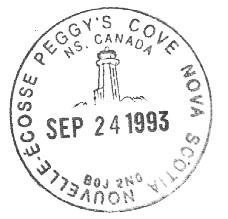
Peggy's Cove is a small rural community located 27 miles west of Halifax on the eastern shore of St. Margarets Bay in Nova Scotia's Halifax Regional Municipality, which is famous for the Peggys Point Lighthouse (established 1868). In 1919 the population was 180 and by 1956 the population had decreased to 60.
According to legend, Peggy's Cove was named after the only survivor of a schooner that ran aground and sank in 1800 ... a woman named Margaret. Local folk called her "Peggy" and her home came to be known as Peggy's Cove. The original lighthouse was built in 1868. Exactly 100 years later, in 1968 the Campbell family opened the Sou'Wester Restaurant. The post office is housed in the Sou'wester Restaurant during the winter and the lighthouse in the summer. It is this lighthouse that is seen on its pictorial postmarks.
This cover was cancelled at the post office situated in the lighthouse at - PEGGY'S COVE / N.S. CANADA / NOVA SCOTIA NOUVELLE - ECOSSE / B0J 2N0 / AUG 21 1995 / - pictorial postmark. This pictorial hammer was proofed 16 JULY 1993 and was the fourth pictorial postmark that was used at Peggy's Cove.
Link to an article on the closing of Peggy's Cove post office: www.cbc.ca/news/canada/nova-scotia/peggys-cove-loses-post...
Woman & Child. RPPC.
1909? COOPERSTOWN N. DAK. Postmark.
Sent:
Mrs. Glen J. Simpson
Cooperstown, North Dakota
[07042]
Parker Road (Kings County), Nova Scotia was located near Aylesford. The post office opened - 1 January 1900 and closed on 28 February 1914 at which time the mail was delivered by "Rural Mail Delivery".
Postcard was sent to: Mrs Thomas Wagner / Aylesford / Parker Road / Kings County / Nova Scotia
/ PARKER • ROAD / AP 14 / 11 / N.S. / - split ring cancel - this split ring hammer is not listed in the proof book. It was most likely proofed around the time when the post office opened on 1 January 1900.
Postcard sent from: / UPPER • BRANCH / AP 11 / 11 / N.S. / - split ring cancel - this split ring hammer is not listed in the proof book.
1902 cover Ymir, B.C. to Finland, via Nelson, B.C, 1¢ + 2 x 2¢ Numerals (5 cents U.P.U. letter rate).
Cover franked with (#75), 2 x (#77) 1¢ and 2¢ Victoria Numerals, posted at Ymir B.C. to Kokkola, Finland. Postmarked with Ymir broken circles / split rings - SP 28 1901. On reverse, is same day Nelson, B.C. transit and October 16, 1901 Gamlakarleby (equivalent name in Swedish) / Kokkola receiver.
Canada International letter mail rates from Canada to Universal Postal Union (U.P.U.) destinations. For each 1/2 ounce from 1 January 1892 to 30 September 1907 the rate was 5 cents.
Link to - Canada International (U.P.U.) Letter Rates : 1892 - present - postalhistorycorner.blogspot.com/2014/02/canada-letter-ra...
------------------------------------------------------------------------------------------
Ymir is a small town in the Regional District of Central Kootenay of British Columbia, Canada. It is located between Nelson and Salmo on Highway 6. Ymir was originally known as Quartz Creek. The townsite was laid out in 1897 by railway magnate D.C. Corbin. Today Ymir consists of a store and two hotels, plus an assortment of residential properties. It is located near Whitewater Ski Hill. The Salmo River runs through the center of the town. Ymir is about 10 km from the town of Salmo, where the annual music festival Shambhala takes place. The name Ymir is originally that of the father of all giants in Scandinavian mythology, whom Odin slew to make the world from his bones, blood and skull (mountains, sea and sky). Local pronunciation of the name is WHY-mirr. The name originally referred to the nearby Ymir Range, and was applied by geologist and explorer George Mercer Dawson.
Link to an article - PLACE NAMES: Ymir - In Norse mythology, Ymir is pronounced ee-mer. So why do we say why-mer instead? - www.rosslandnews.com/opinion/place-names-ymir/
- from 1908 "Lovell's Gazetteer of the Dominion of Canada" - YMIR. a post settlement in Kootenay District, BC, on the Salmon River, and a station on the Nelson & Fort Sheppard Railway, near the International boundary line. It has 2 churches (Roman Catholic and Presbyterian), 4 stores, 9 hotels, 1 saw and planing mill, 1 printing and newspaper office ("Ymir Herald," weekly), and Great Northern telegraph and express offices. The population in 1908 was 400.
(from - Wrigley's 1918 British Columbia directory) - YMIR - a post office and gold-mining town, on the Great Northern Railway, 18 miles south of Nelson, and 35 north of the International Boundary, in Ymir Municipality, Trail Provincial Electoral District. It is situated on Salmon River. Has waterworks, telegraph and express offices. Presbyterian and Roman Catholic churches. The population in 1918 was 300. Local resources: Lumbering, logging and mining.
Link to - A Brief History of Mining in Ymir, B.C. - ymirbc.com/a-brief-history-of-mining-in-ymir/
The Ymir post office opened on - 1 August 1897. (Its only closure was between Oct. 2 and Dec. 7, 2015.)
/ YMIR / SP 28 / 01 / B.C / - split ring cancel - this split ring hammer (first) was not listed in the Proof Book - it was most likely proofed c. 1897 - (RF B). The second split ring hammer from Ymir was proofed - 6 January 1912.
Sent via - / NELSON / PM / SP 28 / 01 / B.C. / - cds transit
------------------------------------------------------------------------------------------
Letter was addressed to: Neiti (Miss) Sigrid Gebhard / Kokkola / Finland / Europe / o.s. Chydenius
Sigrid Maria Gebhard was born on July 19, 1883, in Toholampi, Lansi-Suomen Laani, Finland, her father, Fredrik, was 53, and her mother, Anna, was 34. She married Gustaf Walter Ahrenberg in 1909. They had three children during their marriage. She died on August 18, 1927, in Helsinki, Lansi-Suomen Laani, Finland, at the age of 44.
Kokkola (Swedish: Karleby) is a town and municipality of Finland. The town is located in the province of Western Finland and is part of the Central Ostrobothnia region. The town has a population of 47,706 (31 January 2019). The Finnish name Kokkola means "place of bonfire" or "place of eagle" because the Finnish root word kokko means both bonfire and white-tailed eagle. The town was known in Swedish by the name Gamlakarleby until 1 January 1977 when the surrounding land municipality of Kaarlela (Swedish: Karleby) was consolidated with Kokkola, and the town took over the Swedish name of Karleby. The word gamla means "old", karl means "man" or "peasant" and by means "village", in tearn literally meaning '"old village of peasants" or Anglicised as "Old Peasantville".
/ GAMIAKARLEBY * KOKKOLA / 16 X 01 / - trilingual Finnish - Swedish - Russian arrival cancellation.
Looking N. W. from the Court House, Moscow, Idaho
Olaf P. Larson, Stereoscopist
Date: 1908
Source Type: Stereocard
Publisher, Printer, Photographer: Olaf P. Larson
Postmark: Not Applicable
Collection: Steven R. Shook
Remark: This image is taken from a stereocard published by Olaf P. Larson from Squirrel, Fremont County, Idaho.
The photograph was taken from the roof of the Latah County Courthouse, which, at this time, afforded the best panoramic views of Moscow. Prior to the construction of several grain silos in Moscow, most panoramic photographs of Moscow were taken from the courthouse roof.
The structure known as the Federal Building and Post Office, which would be located in the upper right quadrant of this photograph, has yet to be constructed; that building was to be completed in 1911.
Olaf P. Larson was a photographer specializing in stereoscope photography. From 1895 to about June 1900, Larson resided in Moscow, owned and operated a photography studio, and is believed to have attended the University of Idaho. He later moved to Squirrel, Idaho, where he continued his photography business and also farmed.
Copyright 2016. Some rights reserved. The associated text may not be reproduced or transmitted in any form or by any means, electronic, mechanical, photocopying, recording, or otherwise, without prior written permission of Steven R. Shook.
Friday Finds ... at kimklassen.com
Love books, old photographs and postcards
... and old postmark stamps ...
I found this Photoshop Tutorial by 'fuzzimo',
love it ...
with Kim's texture 'addsomenoise4'
and Photoshop Instagram Action 'Gotham'
1910 postmarked postcard view of Muncie, Indiana. Although the postcard is postmarked 1910, it is likely the photograph used in the production of this postcard was taken two to three years prior. The Muncie Indiana in Vintage Postcards book¹ includes a real photo postcard showing this same scene. According to the authors, an unidentified photographer took the photograph from the smokestack of the Muncie Electric Company. The 1911 Sanborn™ fire insurance map set for Muncie shows the 235-foot reinforced concrete smoke stack standing near the center of the block bounded by West North Street on the north, North Walnut Street on the east, West Gilbert Street on the south, North High Street on the west and Water Street on the northwest. The Delaware County Courthouse in the lower right-hand corner dominated the scene. The tower clock time was 4:00.
The white buildings at the center of the left edge of the postcard stood along the east side of Mulberry Street south of Main Street. The red L-shaped building stood on the southeast corner at the Jackson Street intersection. That was the Delaware Hotel. A little farther south on Mulberry Street, the dome and bell tower of the First Presbyterian Church were clearly visible on the northwest corner of Mulberry and Charles streets. All of these structures are gone.
Walnut Street extends from the bottom center of the postcard past the east side of the courthouse to the horizon. The six-story white building near the center of the postcard was the Wysor Building. It stood on the southwest corner of Walnut and Main Streets. Beyond the Wysor Building, part of the Anthony Building was visible. It stood on the northwest corner at Jackson Street, but both of those buildings are gone.
Very few business signs were visible in this scene, and the only readable sign was on the east side of Walnut Street. It advertised ROHRS & BATH DRY GOODS AND CARPETS and was painted on the side of a four-story building. The 1911 Sanborn™ map set shows a dry goods business at that location, 116-118 South Walnut Street. The 1913-1914 Emerson directory² lists this business (George H. Rohrs and Edwin H. Bath) at this address selling dry goods, notions, cloaks, suits, carpets, etc. The same listing appeared in the 1905-1906 Emerson directory. That building and the other buildings in that block on the east side of Walnut Street are still in use today.
High Street is at the right edge of the postcard. The cross street just beyond (south of) the courthouse is Main Street. Two blocks farther south is Adams Street. Part of the High Street M. E. Church was visible at the right edge of this scene on the northwest corner of that intersection. However, the congregation replaced that structure in 1930. The high school was visible just above the church. The school was located in the center of the block bounded by West Adams on the north, South High Street on the east, West Charles Street on the south and South Franklin on the west. The 1911 map set shows the clock tower at the north end of the building and includes a note saying the tower was 120 feet tall. The Masing and Koenker postcard book³ says the building was demolished in 1912-1913 to make way for construction of the new Central High School.
1. Milton A. Masing and Jeffrey Koenker, Muncie Indiana in Vintage Postcards (Charleston, SC: Arcadia Publishing, 1999).
2. Emerson Directory Company, Emerson’s Muncie Directory 1913-1914 (Cincinnati, OH: Williams Directory Co., 1913). Available online at libx.bsu.edu/cdm/compoundobject/collection/MunCityDirs/id....
3. Masing and Koenker, page 34.
From the collection of Saundra Jackson.
The full postcard image can be seen here.
www.flickr.com/photos/hoosier_recollections/32568454245/i...
Copyright 2002-2017 Hoosier Recollections. All rights reserved. This creative JPG file package is an original compilation of materials and data. The package is unique, consisting of a wide variety of related and integrated components. Neither this package in its entirety nor any of the individual components may be downloaded, transmitted or reproduced without the prior written permission of Hoosier Recollections.
2015 Christmas Island, Nova Scotia Commemorative Cancels
Link to the "Canadian Philatelist" showing the first Christmas Island Pictorial Cancel from 1994 - designed by "Steven Slipp" - www.rpsc.org/CP_scans/Canadian%20Philatelist,%20Vol.%2045...
At Christmas Island, a small community in Cape Breton, Nova Scotia, it’s all about the postmark. The Christmas Island post office is now famous for bringing a festive feel to holiday cards around the world with wreath postmarks that say “Christmas Island.”
Postmistress Hughena MacKinnon has been delivering holiday cheer with the stamp since 1994. Ms. MacKinnon forwards holiday letters around the world after postmarking them with the famous holiday stamp.
“They add a little extra holiday flair,” said Canada Post spokeswoman Anick Losier.
“The stamp has been altered for 2010,” said Ms. MacKinnon. “They’ve added some extra decoration to the wreath [on the stamp].”
She said that during the summer months the post office receives around 100 letters a day, yet during the holiday season that number escalates to around 1,000.
Mail is sent through the office — with postage enclosed — to be stamped and forwarded, by the postmistress, around the world. To have your holiday cards postmarked, send your addressed cards with proper postage in a larger envelope, and address to:
Christmas Island post office
8499 Grand Narrows Hwy
Christmas Island, N.S., B1T 1A0
Link to videos - N.S. post office gets thousands of letters from senders looking for Christmas stamp - www.youtube.com/watch?v=ZFUg6joeSgg
Christmas Island's postmark a coveted holiday mail stamp - www.youtube.com/watch?v=U2xwV8h6qw8
Link to an article - Unique postmark keeps N.S. post office busy during the holidays - www.ctvnews.ca/canada/unique-postmark-keeps-n-s-post-offi...
Peterborough is a city in eastern England. It’s known for the 12th- and 13th-century Peterborough Cathedral, with its Gothic facade. In a former hospital building, the Peterborough Museum has a reconstructed Victorian operating theatre, plus fossils and paintings. Flag Fen Archaeology Park features Bronze Age village and causeway remains. Nene Park is home to woodlands, footpaths and Ferry Meadows recreation area.
Mailed from - / PETERBOROUGH / 7.30 PM / JA 28 / 09 / 2 / - double ring postmark
------------------------------------------------------------------------------------------
As to the origin of Fire Valley, the BC Minister of Mines report for 1901 said it was “so called from the fact that a fire swept up the valley and killed all the trees on both hillsides,” but didn’t give the date of the fire. Another theory suggests red granite surrounding the valley might have been the name’s origin.
An application for the Fire Valley post office was filed in 1893, but it didn’t open until almost a year later. In 1906, the post office was renamed Needles, although it’s unclear whether it actually moved. The name reverted back to Fire Valley in 1908 and closed in 1910. A new Needles post office was established in 1908 and closed in 1968 upon the flooding of the Arrow Lakes. Today the only thing left of the old community is its cemetery.
From - BRITISH COLUMBIA POSTAL HISTORY RESEARCH GROUP - JUNE 1995 - FIRE VALLEY - Pete Jacobi provides a number of quotes from the late Marvel Milne's book duet where is Edgewood? regarding the establishment and location of Fire Valley and the change of name to Needles. The main question is "Why there was a distinction between Needles (1) and Needles (2) when its postal service was continuous from October 1, 1906 to March 7, 1968". This is not the first time this question has been asked. The postal records clearly show what officially happened but fail to recognize that Needles moved back and forth from one side of the narrows to the other and at least one postmaster appears to have moved taking the post office with him. Ms. Milne states that "By the fall of 1894 there were twenty-two settlers. They found a post office was needed, so John Bangs contacted the authorities and they gave him permission to have one in his house in October of that year. In 1902 John went to Calgary to study law so he could become the Justice of the peace." Like many local historians Ms. Milne is partly correct. The Fire Valley Post Office was established on October 1, 1894 but the postmaster was O.J. Vail, not John Bangs. Mr. Bangs had pre-empted land on Barnes Creek near the present Needles Airport in 1891 but did not become postmaster until March 1, 1898. His land was some 4 miles up the creek from Needles spit on the Arrow Lakes and 10 miles from Killarney Landing located near the present site of Edgewood. Mr. Bangs left for Calgary in October 1902 and two months later Mr. R. Shiell took over the Fire Valley post office. Indication are that Mr. Shiell lived near the Needle, a narrow spit of land, on the west side of the narrows between the Upper and Lower Arrow Lakes. Shortly after taking over the Fire Valley Post Office he had the name changed to Needles. He resigned July 1, 1908 at which time the name of the Needles (1) Post Office was changed back to Fire Valley (2) and a new Needles (2) Post Office was established. Maps of the period show the Needles Post Office on the east side of the narrows not in its present location on the west side. The Fire Valley Post Office remained in operation until October 24, 1910 when it was closed, listed as being "no longer required". Some time between the closing of the Fire Valley (2) Post Office in 1910 and the opening of the Fauquier Post Office on June 1, 1913 the Needles Post Office must have moved back to the west side of the lake near the present Needles ferry landing. The Needles office was closed April 30, 1968 and the Fauquier office was moved to its present location following the building of the Arrow Lakes Dam.
- from 1908 "Lovell's Gazetteer of the Dominion of Canada" - FIRE VALLEY, a post office in Kootenay District, B.C., near the Arrow Lakes, on the steamboat route from Arrowhead to West Robson.
The name reverted back to Fire Valley - 1 July 1908 and closed - 24 October 1910
/ FIRE VALLEY / FE 13 / 09 / B.C. / (2) second opening - split ring cancel - this split ring hammer was proofed - 16 June 1908. (RF E)
This Post Card was addressed to: Mr. James Dalton / P.O. Fire Valley / British Columbia / Canada
Message on postcard reads - Don't let this poor old place get burnt up this time. I hope you get this alright. Love from all - Margaret
Canada Census, 1911
Name - James Dalton
Event Place Yale and Cariboo Sub-Districts 1-54, British Columbia, Canada
Gender - Male
Age (Estimated) - 39
Marital Status - Single
Religion - Anglican
Relationship to Head of Household - Lodger
Birth Date - Mar 1872
Birthplace - England
Immigration Year - 1902
Postmarked Bournemouth, 1918, with the slogan: "Buy National War Bonds Now" AND Christchurch, Hants, 1918.
1909 postmarked postcard view of Main Street in Churubusco, Indiana. The photographer was looking southeast from the Washington Street intersection. The farthest buildings in this scene were south of the Vandalia Railroad tracks.
The sign on the building at the left edge of this scene advertised O. GANDY & CO. THE EXCHANGE BANK. The 1905 Sanborn™ fire insurance map set for Churubusco shows a repository in the north half of that building and the bank in the south half. The 1911 map set identified the repository as a carriage repository. A 1910 state auditor’s report¹ identified the bank as The Exchange Bank of O. Gandy & Co. and indicated a Certificate of Authority had been issued in 1905. Oscar Gandy was the owner. The 1907 Whitley County history included the following paragraph about the founding of the bank.
“On September 11, 1893, Oscar Gandy established the "Exchange Bank" under the firm name of O. Gandy & Co.. with a capital of $10.000. The Exchnage [sic] Bank has always done a prosperous business and is considered one of our most substantial financial affairs and has increased its capital to $25,000. The present officers and employes are O. Gandy, president; E. E. Gandy, cashier; John A. Pressler, assistant cashier; Ursula Magers, bookkeeper; Minnie Anderson, stenographer; and George Gump, janitor.“²
The history also included an entry on page 305 stating the bank building was built in 1898.
Two brick buildings stood south of the bank building. Business names were printed on the awnings, but are not clear enough to read. The 1905 map set shows a meat market in the north building and department store in the south building. The 1911 map set shows the meat market and a clothing, dry goods and furniture business in the buildings.
Next door, the wood frame building housed (from north to south) the Churubusco Post Office, a bakery and a barbershop according to the 1905 map set. The 1911 map set shows a newer and longer brick building that housed (from north to south) a notions business, the post office, a confectionery and tobacco business, a jewelry business and a barbershop. The only visible sign on that building in this postcard scene was the US POST OFFICE sign.
Across the street, the most distant businesses were south of Whitley Street. Two of the signs appear to advertise a MEAT MARKET and A GROCERY. The 1905 and 1911 Sanborn™ map sets show a grocery in that block, but not in the different locations for each year. Neither shows a meat market. Another small sign in that block advertised a lunch room, but it’s difficult to tell which building the sign is on. The 1905 map set shows two restaurants in that block and the 1911 map set shows a single restaurant.
Farther north (closer to the photographer) were signs advertising CITY DRUG STORE, DENTIST and ICE CREAM SODA. The soda sign undoubtedly belonged with the drugstore sign. It is difficult to tell which signs belonged with which building. Although these signs may appear to be in front of one of the two two-story brick buildings, they were probably in front of the wood frame building across the alley to the north. Both map sets show a drugstore as the second business north of Whitley Street in a two-story wood frame building on the north side of the alley. This was directly across Main Street from the post office. The 1905 map set actually identifies the store as a drugs and stationery business.
The 1907 county history listed J. F. Criswell & Son and Miss Mary Eikenberry & Co. as owners of drug stores in town. However, a 1905 directory of retail druggists listed the names as Craig & Boggs and Eikenberry & Co. A 1908 directory listed A. B. Craig and Mary Eikenberry.
The only dentist listed for Churubusco in a 1914 directory was Frank B. Weaver, a 1900 graduate of Northwestern University Dental School in Chicago. The dental office would probably have been upstairs and the Sanborn™ map sets typically don’t identify those offices unless they are in separate buildings.
The awnings at the right edge of the postcard were on a group of small buildings near the southwest corner of Washington Street. A wood frame building stood on that corner and is outside this view. It housed a grocery and millinery shop. The awning at the right edge of this postcard may belong to the millinery shop. The other awnings were on a brick building south of the corner, and one awning appears to advertise M. KOCHER. Both Sanborn™ map sets show a boots and shoes business at that location. The 1907 county history reported that Mr. Kocher built a brick building in Churubusco in 1892 and ran his boots and shoes business in the building.
1. Auditor of the State of Indiana, Annual Report (Indianapolis, IN: William B. Burford, 1910). Available online at books.google.com/books?id=l_dJAAAAMAAJ&printsec=front....
2. Samuel P. Kaler and Richard H. Maring, History of Whitley County, Indiana (Indianapolis, IN: B. F. Bowen & Company, 1907), pages 307-308. Available online at books.google.com/books?id=-hUVAAAAYAAJ&printsec=front....
This image was created by Thomas Keesling from a postcard courtesy of the Indiana Postal History Society.
The full postcard image can be seen here.
www.flickr.com/photos/hoosier_recollections/27546603985/i...
Copyright 2005-2016 by Hoosier Recollections. All rights reserved. This image is part of a creative package that includes the associated text, geodata and/or other information. Neither this package in its entirety nor any of the individual components may be downloaded, transmitted or reproduced without the prior written permission of Hoosier Recollections.
Addressed to: Mr. Donald Koos, / 8150 Marlowe, Detroit, Michigan, 48228
Donald Andrew Koos
(b. 22 September 1947 in Detroit, Wayne, Michigan, United States - d. 30 July 1978 at age 30 in Ann Arbor, Washtenaw, Michigan, United States)
(16 March 1958) - LINK to a newspaper article - Donald Koos Collector - www.newspapers.com/article/detroit-free-press-donald-koos...
Many people are assaulted each year by their coworkers, but it seems unusual that it would happen at a hospital. On July 30, 1978, this occurred at the University Hospital as William Aparicio shot Donald Koos five times, two of which were in the head. Koos died from his wounds five hours after the shooting, despite being operated on by some of the best brain surgeons in the world.
Koos was the acting chief administrator at the U of M's Neuro-Psychiatric Institute and Aparicio was the manager for fiscal affairs. The two of them had worked together for 18 months before the shooting occurred.
On the day of the shooting the two became involved in an argument and Aparicio pulled out a .38 caliber revolver and shot Koos five times. The two had a strained relationship but no one would have guessed their feud would lead to the shooting.
After the shooting Aparicio calmly walked back to his office still carrying the weapon. He asked his secretary to call police and sat down and waited for them. Shortly thereafter Officer Harry Jinkerson arrived and placed him under arrest without incident.
Evidently a less than flattering job evaluation of Aparicio's performance infuriated him and this seems to have triggered the attack. Lt. Donald Johnson stated, “This is a very simple case, actually. It's one of those classics. These two men had trouble on the job and it ended in one killing the other.” LINK to the complete article - aadl.org/aapd/truecrimes/8-13
Donald Koos Shot 5 Times - LINK to newspaper article - www.newspapers.com/article/the-flint-journal-donald-koos-...
Donald Koos who Died from Ann Arbor Shooting - Shown with his Collection of Celebrity Drawings - LINK - www.newspapers.com/article/the-kalamazoo-gazette-donald-k...
----------------------------------------------------------------------------
- sent from - / PRESIDENTS HOUSE / 8 MAY 68 / 2 P.M. / RAWALPINDI / - double ring cancel
STUART RIVER, B.C. — PREVIOUSLY UNREPORTED BRITISH COLUMBIA POST OFFICE - from the Ashcroft collection. He purchased this postcard from eBay on - 7 July 1911 - www.worthpoint.com/worthopedia/stuart-river-bc-split-ring... The eBay listing write-up mentioned - Stuart River BC - Canada - A split ring postmark on a picture postcard mailed to Winnipeg in 1922. The picture side shows an insignificant colour view of Nanaimo harbour. Topping shows this postmark as a "hammer proof only", but I understand several receiver backstrikes exist, which would make it an RF-E. This is your chance to bid on a Stuart River despatch postmark, so feel free to show complete lack of restraint! - and then he corrects this by saying - CORRECTION: Please ignore my earlier comments regarding scarcity. The comments in the description above apply to Stewart River in the Yukon, not Stuart River, BC ........
This is the FIRST REPORTED EXAMPLE of a Stuart River, BC postmark !!!!
---------------------------------------------------------------------------------------
FINMOORE, 56 km west of PRINCE GEORGE on the CNR, is a farming settlement beside the NECHAKO River named after P. Moore, early settler and first postmaster. Formerly known as Stuart River, it is just west of where this tributary joins the Nechako at the former site of CHUNLAC, a historic DAKELH (Carrier) village. Written by Andrew Scott
Finmore (old maps referred to it as Finmoore) is a station on the CNR about 50 miles west of Prince George. Besides the station and sectionmen's quarters there is a store and post office serving a population of about 25 farmers, tie contractors, railway workers and one inhabitant listed as "retired". (1954)
Stuart River, 60 miles long, runs from south of Stuart Lake into Nechaco River, 55 miles west of Fort George.
The most northern watershed of the Fraser Basin is the Stuart. The Stuart River (named after NWC fur trader John Stuart) originates at the south end of Stuart Lake near Fort St. James and flows southeastward for 187 km to join the Nechako River 55 km west of Prince George. Takla Lake (from the Dakelh term meaning "at the end of the lake") empties to the southeast via the Middle River into Trembleur Lake and then into Stuart Lake.
STUART RIVER - a P.O. (Railroad name was Stuart) station and farming settlement on the G.T. P.R. and Nechako River, in miles east of Vanderhoof, the nearest telegraph office, and 50 miles west of Prince George, in Fort George Prov. Elec. Dist. Local resources: Farming and Railroad ties. McBride N.J. - farming, general store and Postmaster.
Nathaniel John McBride was the Postmaster at Stuart River, B.C. from 1 October 1919 - until he resigned in the summer of 1921 when he was charged with the murder of Issac Williams in Prince George, B.C. - Percy Moore replaced him on - 29 September 1921. Here is the newspaper version of the murder...
Prince George, British Columbia, Friday, July 22, 1921 - Drunken Brawl Ends in Death of Issac Williams, Of Shelly, Man of Sixty Years Charged - "The Postmaster at Stuart River, B.C. - N. J. McBride" (Nathaniel John McBride b. 1878 - d. 1939) - According to the evidence, the said Issac Williams came to death on July 17th, 1921 at the Prince George Hospital, at 10:08 PM, from wounds caused by blows administered by N.J. McBride at Room 110, Express Hotel, George Street, during a drunken brawl. We therefore return a verdict of manslaughter. Above is the verdict of the Jury empaneled by Coroner Guest, on Tuesday's inquest over the body of Issac Williams, a section hand on the C.N.R. Living at Shelly. N.J. McBride, a railway pumpman, storekeeper and Postmaster of Stuart River, is held on the charge of killing Williams. The accused, N.J. McBride, was standing in the room, in a drunken condition, with the neck of a broken bottle in his hand. Williams was a returned soldier and according to effects found in his pockets received his discharge in Halifax in April 1919. He was a Welshman, his mother still residing in Wales - Link to his WW1 records - www.bac-lac.gc.ca/eng/discover/military-heritage/first-wo...
N.J. McBride, charge with the death of Williams, is a man of nearly 60 years of age. He bears the reputation of an industrious citizen and besides his position of pumpman, for the railway, has a farm and a store at Stuart River, about 50 miles west of Prince George. His wife Emma L. McBride is a highly respected lady, is now in the city. Three small children of a deceased married daughter are being cared for by the McBrides.
Said to be Enemies - Just what occurrence precipitated the row that led to Williams' death will perhaps never be known, but railway men state that bad blood had existed between McBride and Williams for some time.
---------------------------------------------------------------------------------------
The Post Office at Stuart River was established - 1 October 1919 - changed name to Finmoore - 1 April 1923 and closed - 31 October 1956.
/ STUART RIVER / MY 27 / 22 / B.C. / - split ring cancel - this split ring hammer was proofed - 26 August 1919.
---------------------------------------------------------------------------------------
Message on postcard reads - 24th - Received yours D. also picture. We think it is fine. am returning by same mail. Hope you are soon finish No 4. Wm (William) is here for 3 or 4 days & will be away next week or 10 days. Keeps cool here yet, but we haven't had much rain this spring. Hope all are well. We are very busy. ??????
Addressed to: Miss D. Davidson, 526 Beverly Street, Winnipeg, Manitoba