View allAll Photos Tagged maps
Map background courtesy of:
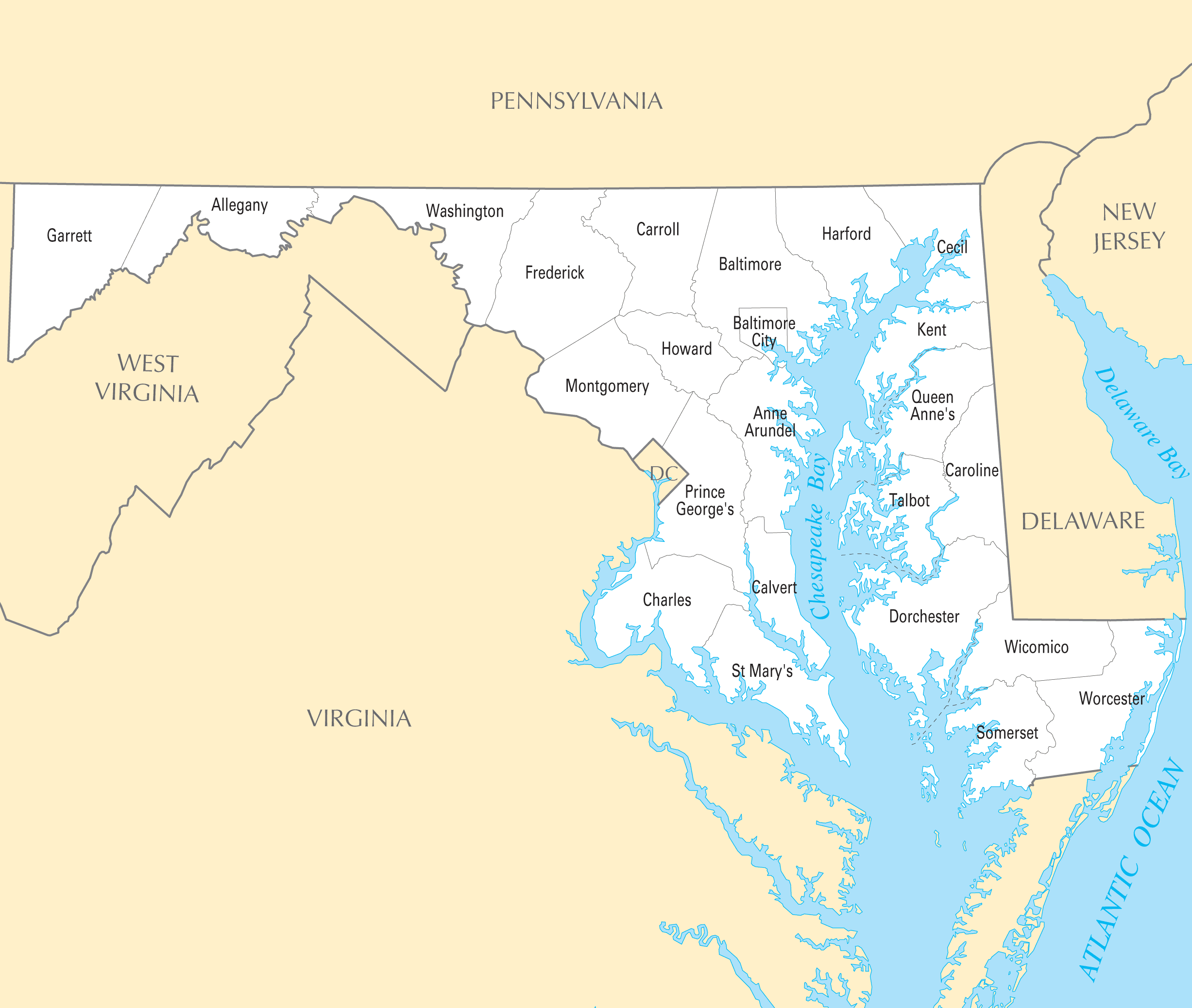
mapsof.net/uploads/static-maps/maryland_county_map.png
------------------------------------------------------------------------------------------
If you would like to use THIS picture in any sort of media elsewhere (such as newspaper or article), please send me a Flickrmail or send me an email at natehenderson6@gmail.com.
with thanks to www.midlandrailwaystudycentre.org.uk/contents.htm
The railway was an East West link of 183 miles and 20 chains between Yarmouth, Norwich and Peterborough with its works at the four way crossing at Melton Constable. 2 sections survive in use: the Cromer to Sheringham section of the national network and Sheringham to Holt (almost) as a preserved steam operated line.
Loner's Paradise MOC (still work in progress) is a build inspired by the drawings of the Swedish author Jan Lööf.
Collection of old maps scanned from books and other print sources Download them all at Photoshop Roadmap.
Memory map of a route in my hometown, St. Albans.
Stitched map illustration onto white linen fabric.
Yes, I see the irony in having a world map and a compass while that case literally contains a smartphone with all the things in it but...deal with it, it's pretty.
Description: Map of Pennsylvania with raised lines and braille.
Note: Map with tactile elements for use by the blind.
Creator: unknown, United States
Date: ca. 1930
Format: map
Digital Identifier: MAPS-00015
Rights: Samuel P. Hayes Research Library, Perkins School for the Blind, Watertown, MA
Printable tourist attractions map of Nashville.
Created by Tripomatic
www.tripomatic.com/United-States-of-America/Tennessee/Nas...
Maps of racial and ethnic divisions in US cities, inspired by Bill Rankin's map of Chicago, updated for Census 2010.
Red is White, Blue is Black, Green is Asian, Orange is Hispanic, Yellow is Other, and each dot is 25 residents.
Data from Census 2010. Base map © OpenStreetMap, CC-BY-SA
Printable tourist attractions map of Orlando.
Created by Tripomatic
www.tripomatic.com/United-States-of-America/Florida/Orlan...
Thanks to AFB for the store's number.
------------------------------------------------------------------------------------------
If you would like to use THIS picture in any sort of media elsewhere (such as newspaper or article), please send me a Flickrmail or send me an email at natehenderson6@gmail.com.
Turkey map www.mapsofworld.com/turkey/
shows the major geographical boundaries, cities and provinces of Turkey. Mapsofworld.com provides exclusive collection of maps of Turkey including Physical map, outline map, City Maps, Province maps
ck` e ếi ... ♥
bên tay trái nhoeee ... ♥
♥♥♥♥♥♥♥
dnài vào học r` nhưg vui l' ... ♥
hp vô cùg ... ♥
iu ck` e cực luôg ... ♥
ngài nào k~ đc gặp ck` nè ... ♥
ôi ... ♥♥♥
i luv more than i can say ... ♥
...
p/s: vào năm học r` .... ♥
chúc mấi bn. kóa 1 năm học vv~ nhoe ... ♥
ai kóa lòg tút thì fav + note cho mìg luôg he ....
ôi cí f* nì là cí chùaaaaa =]]]] XXX ... ♥
Collection of old maps scanned from books and other print sources Download them all at Photoshop Roadmap.
Seriously! WTF! How am I suppose to drive to get to point B when I'm taking public transportation!!!! Follow the notes.. ;)
I hope this might clear up some confusion on the Banded watersnake species (Nerodia fasciata). I get queries constantly about this from flickerites. There are 3 "Banded" watersnakes:
Southern Banded Watersnake
Broad Banded Watersnake
Florida Watersnake (Florida Banded Watersnake) As you can see the only "Banded" watersnake in most of Florida is the Florida Watersnake (Nerodia fasciata pictiventris) Some folks like to call the Florida Watersnake (Fl. banded watersnake) a Southern Watersnake but this can be very misleading as the Eastern Green Watersnake and the Brown watersnake are both found in the same range and they are both "watersnakes"
THIS MAP IS FROM THE BOOK: North American Watersnakes by Gobbons & Dorcus, Published by the UIniversity of Oklahoma Press>