View allAll Photos Tagged map
Map Number 2020-024; Replaces Map Number 2014-151
***
To view a larger version of the map, right click on the map and choose a different size from the "View All Sizes" links. For directions on how to download a map, our contact information, and answers to other questions, please click here.
I've uploaded the image on the right a few times already. That image is of my map of the current Kmart stores in Florida, which currently stands at a total of 41 stores. For the first part of the upcoming AFB on flickr photoseries, we're going to be taking a look at the most recent Florida Kmart casualty - the closing of the West Palm Beach Kmart. The closing of the West Palm Kmart began on May 20, 2016, and that store's closing should be entering it's final days by now, if it hasn't closed for good already. I visited the West Palm Kmart on May 18, 2016, two days before the closure began. For the record, I had no idea the store was going to close when I made the trip down there. The timing was a complete coincidence. However during my visit there were a few signs of an upcoming closure in the works, which I will discuss in more detail as I get into those photos.
As I was looking for some information on Kmart not too long ago, I stumbled upon a list of licensing data from the State of Florida from 1996. Their list included information on the locations of every Kmart in the state in that year. So using that data, and filling in a few gaps with some other stores I knew of that closed prior to 1996, I complied a list and map of every Kmart (that I know of) to have existed in Florida over the years. You can see that map on the left. According to my count, there have been at least 184 Kmart stores to have operated in Florida over the years (that count includes original stores and their replacements). As of today, over three quarters of the Kmarts to have operated in Florida have since closed. However, I think the comparison between the two maps speaks the loudest over any statistical figures.
If you would like to view an interactive version of the map of all Kmarts to have operated in Florida, please click here. To view an interactive version of the map of current Kmart stores in Florida, please click here.
Please comment below if those links don't work or if you know of a former Kmart location that I may have missed.
Map showing Angola and surrounding countries with international borders, the national capital, major cities, main roads, and railroads.
By Andrés Bentancourt
EyeEm | 500px | Flickr | Instagram | Tumblr | Twitter | DeviantArt | Pinterest | Facebook | Contact email
I am reposting this map from the University of Texas so I can comment on it, because every time I look at it I see something new that's weird about it.
It is supposedly from 1913, but it looks like the street map must be earlier since the Civic Center is still in the pre-1906 configuration and street names like Ridley and Kate persist.
Montgomery Street continues straight south to 16th and Connecticut!
16th Street continues west over Corona Heights to connect to Irving!
18th Street also makes it as far west as Stanyan.
The "Right of Way for the Southern and Western Pacific Railroad" runs across Candlestick Point and into the bay, like a prototype for the Hunters Point Freeway.
Market Street continues southwest over the hills and includes what is now Sloat.
Army (Cesar Chavez) is called New Market in Noe Valley.
The Bayview/Hunter's Point streets all have different names.
The Mission grid extending west to Fowler and south to 34th Street, and the Lake Merced grid, are contrary to reality too, but those aren't unique to this map.
Source: McGraw Electric Railway Manual: The Red Book of American Electric Railway Investments, the University of Texas Libraries.
This map goes along with this post, which was an attempt to inventory all the independant shops and businesses in my area of central Austin.
This is a map of Seoul with some of the places we visited.
Below are my steps to create the map:
1. Using Google Earth, I plotted the location of each attraction.
2. I printed the map and traced over it with white paper and a pencil. I drew in the river and placed an "x" for each attraction.
3. I inked-in the river and drew the landmarks. For all inking, I used a Fine Black Sharpie Pen.
4. Next I lettered each landmark.
5. After erasing all of the pencil marks, I scanned the map and added a couple of elements (Miso, and the Nanta drawing) using Paint. I also added "Han River" as I forgot to letter this by hand.
6. I printed the map onto parchment paper. Once scanned back in to my computer, I e-mailed it to myself so I could complete the editing using my iPad.
7. On my iPad, I added the Torn Brick effect and Rough Edge border.
8. Finally, I added my watermark using the iWatermark app. The watermark is a stone stamp that was created in Korea. The Korean letters phonetically spell my first name, Douglas.
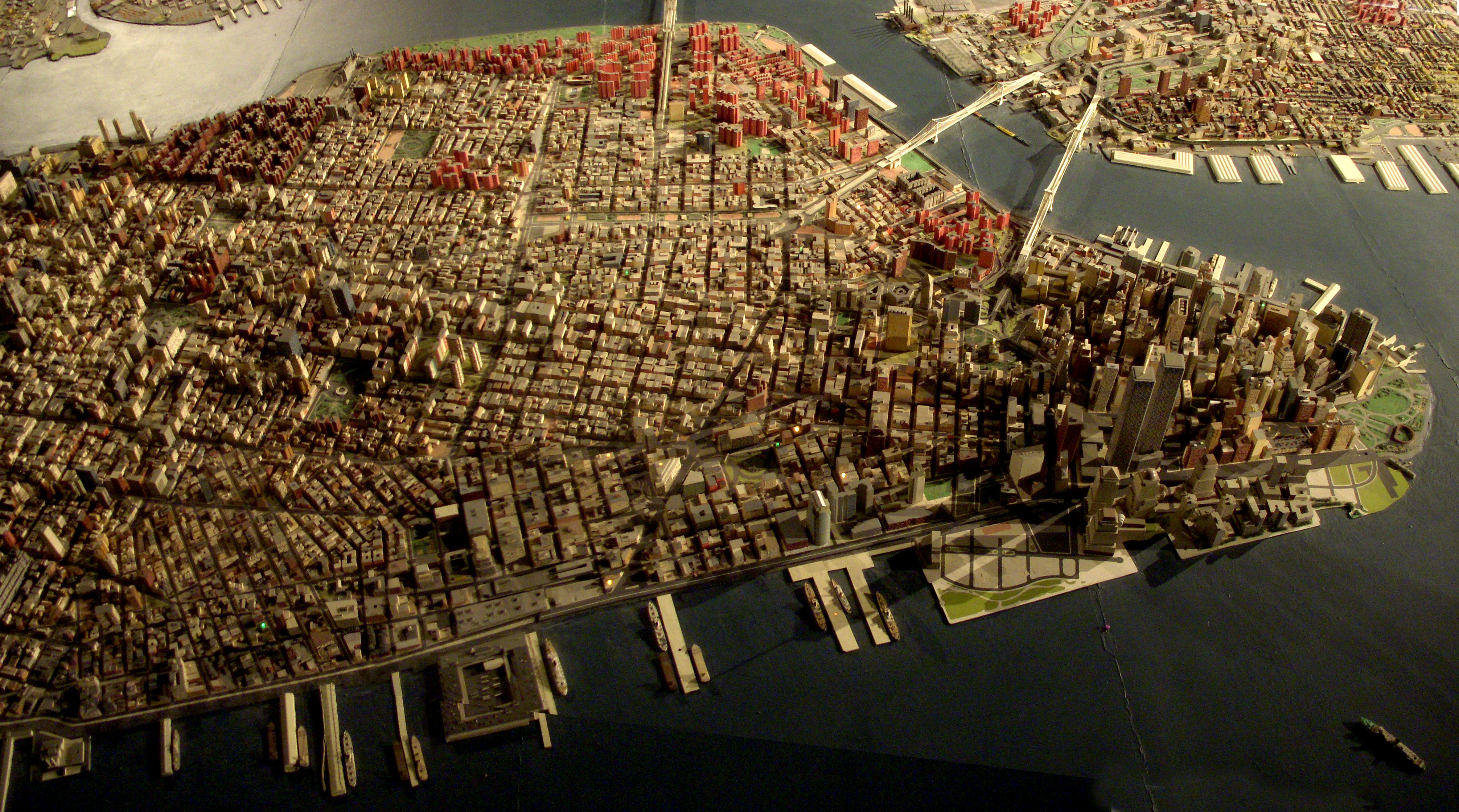
Giant map of NYC in the Queens Museum of Art. I uploaded this full size panorama of downtown Manhattan so my neighbors can have fun finding their own apartment building.
Robert Moses had 'The Panorama of the City of New York' built for the 1964 World's Fair, but it has been updated, and supposedly has every building built before 1992. Originally you flew over it on a simulate helicopter ride. Now there is a ramp that spirals around it from the first to second floor of the museum.
Title: Nova Persiae Armeniae Natoliae et Arabiae [shows Cyprus]
Map Maker: Frederick De Wit
Place / Date: Amsterdam / 1680
Description:
Decorative and highly desireable map of the region bounded by the Saudi Peninsula, Red Sea, Nile River, Cyprus, Asia Minor, the Gulf of Aden, Indian Ocean, Armenia, the Caspian Sea, Afganistan and the Indian Ocean, centered on the Persian Gulf. Includes two attractive cartouches, ships at sea and marvelous geographical detail within the map. One of the few available Dutch maps to mention Armenia in the title of the map and one of the most detailed of the region. Gorgeous example.
Armenia on antique maps
Left & Centre: Modern Pictorial World Atlas c1939
Right: Encyclopaedia Brittanica 10th Edition Maps c1897
Now, I want 60044. And it is my intention to be out for it on the Wensleydale this weekend.
It's a wee bit of a trek from here. But Windows maps seemingly turns a trek into an epic. This was seriously offered up as an option.
Toodle pip. Got a boat to be on...
12 July 2017
Map of the South Caucasus countries (Abkhazia, Armenia, Azerbaijan, Georgia, Nagorny Karabakh, and South Ossetia)
This is a close up of an old map I carry around while exploring Honolulu's Chinatown.
I've linked a few of my pinhole photographs taken in this area [click on notes in map above].
More photos in my Chinatown series.
Map courtesy: University of Hawaiʻi at Mānoa Library, Map Collection
Sanborn Fire Insurance Map, Honolulu, 1914, sheet 37 [cropped].
I noticed I've managed to post just 6 images (and a video) all year, and yes I still look in and make the odd comment on friends streams. When I looked today I saw a nice message telling me I'm four days away from not being pro. At an average then of 12 images per annum I guess thats no worry.
I'll probably delete a couple of hundred dross holiday snaps to allow my two hundred half decent ones to remain.
However, I did come across this, (which I have moved once) which I'd forgotton about.
I notice that since then Kenny is in New Zealand, Jen has moved all over the shop, Tess and Houser are nearly no longer a twosome, but a threesome.
So, apologies for no posts, if you are a new(ish) contact stick yourself on the map.
Thank you.
Description: Map of Massachusetts with political boundaries and topographic relief.
Note: Map with tactile elements for use by the blind.
Creator: Perkins School for the Blind
Date: 1908
Format: map
Digital Identifier: MAPS-00032
Rights: Samuel P. Hayes Research Library, Perkins School for the Blind, Watertown, MA
In the new square at Trondheim, this map of the river Nidelven has been made. Really nicely done.
Digitized with Negative Lab Pro v2.1.0
This was my big summer project this year! A full map of the continental United States all in patchwork and embroidered! You can see more pictures at:
After seeing Cooper Smith's visualizations of data from runners in New York City, I wanted to see what similar data sets would look like for other cities. Nike+ doesn't have public GPS logs, but MapMyRun does, if you are willing to spend several hours clicking through search results to hit the "Download" buttons, so that's what I did to get the tracks for these 771 runs (from June 13 through August 9) in San Francisco.
As Open Source Planning has pointed out, uploaded runs come from a fairly small, self-selected group of people, the most obvious result of which is the total absence of the southeastern corner of the city from this map. It is also a very self-conscious process, so it is biased toward intentional, and often intentionally difficult, trips made for their own sake, and away from the repetitive patterns of everyday life.
Unfortunately the MapMyRun tracklogs do not have date and time stamps, so it is not possible to do the time of day, pace, and interruption analyses that Cooper Smith did. I should have done direction of travel, though.