View allAll Photos Tagged globalchange
The trees look still like summer, thank the exceptionally warm september. Two days ago the thermometer dropped transiently to 4- 5°C during a cold front, but now it raises again...
Another southstream.
At skyline left, the Mont Ruan (around 3050 m) and the Dents Blanches.
But, from now ago as good North- than Southstream will bring snow. Only the altitude limit of snow will change. Down to the plains with nordstreams and between 1000 and 2200 m with south- and weststreams. But the latter are becoming rare, as the Gulfstream weakens.
This pic was also on EXPLORE
Dalla cima della Becca Traversiere.
Grand view on dying glaciers, morains, rocks. Grand Paradiso far in the background
www.gettyimages.it/detail/foto/the-goletta-glacier-immagi...
Future generations will probably look back on the Petroleum Age with a certain amount of disbelief: "They burned it? All those lovely organic molecules, and they just burned it?" (Ken Deffeyes, oil geologist)
Landscapes with a long tele lens it's not my comfort zone. Keeping an heavy 300mm steady under strong wind it's not an easy job, even with a solid tripod and a trigger releaser. Under the circumstances, however, it was the best solution I found for an uninteresting foreground that made my wide angle useless.
Are we in space? do we belong?
Someplace where no one calls it wrong
And like the stars we burn away the miles.
T.a.t.u. - Stars
Title: White Lies - From the Stars.
Kappl, Austria, Feb 22.
I REALLY wanted to try this (:
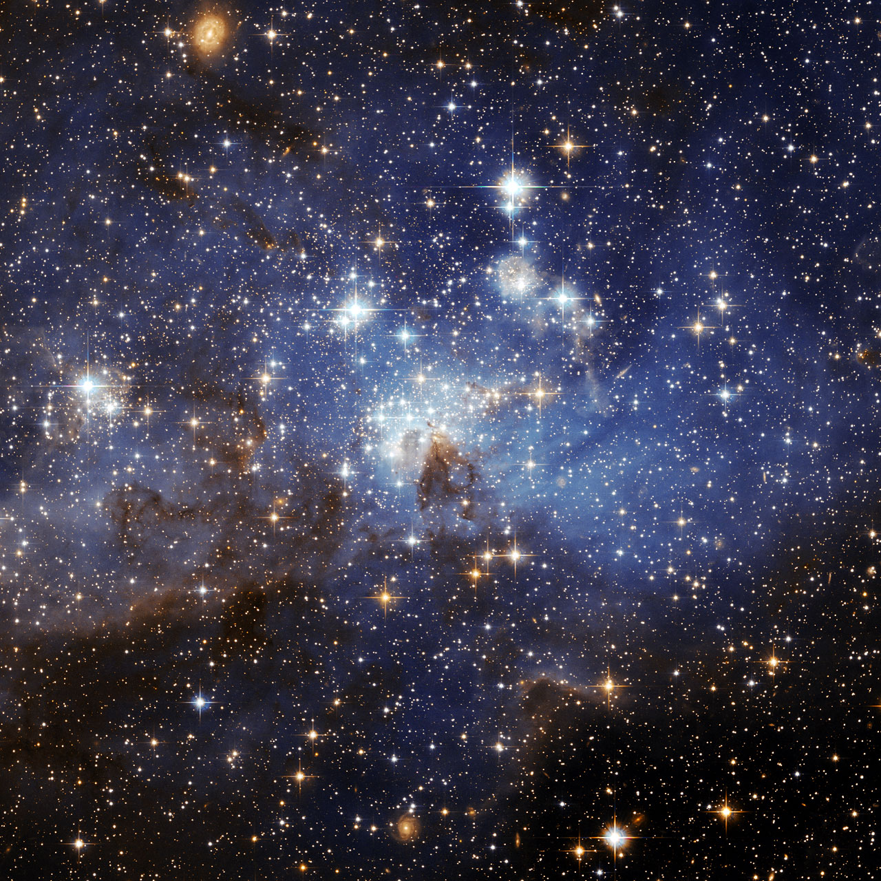
stars image from: www.globalchange.umich.edu/globalchange1/current/lectures...
Youtube: Dream Factory
Photograph by Yusuf Alioglu
This time, we escaped the main stream of the storm. Two years ago, nearly all cultures, gardens and even trees were fully destroyed or heavily damaged by a hail storm which had ice blocks up to 3 -5 cm (diameter of the hail)
Some years ago I encountered a canadian university professor of physics on an alpine refuge. He told me: "if the energy (temperature) of a physical gaseous system (like atmosphere) increases, the frequency of violent events will also increase... "
Climate change poses threats to indigenous peoples’ health, well-being, and ways of life, according to the Third U.S. National Climate Assessment released this week.
As climate change continues to impact their lands and resources, indigenous communities are vulnerable to food insecurity, changing water availability, potential relocation from historic homelands, and the loss of livelihoods and traditional knowledge.
NASA's Innovations in Climate Education-Tribal activity engages students with NASA Earth observation data and Earth system models and provides climate-related research experiences for teachers, undergraduate and graduate students, particularly in the community of Tribal Colleges and Universities.
The Tribal College and University Experiential Learning Opportunity program supports NASA's goal of engaging tribal communities in science, technology, engineering and mathematics disciplines, and focuses on inspiring the next generation of explorers.
To learn more about NASA's education programs, visit:
To learn more about National Climate Assessment findings related to the impacts of climate change on indigenous communities, visit: nca2014.globalchange.gov/report/sectors/indigenous-peoples
To learn more about other NASA missions that contribute to understanding climate change, visit: climate.nasa.gov
To learn more about NASA's Earth science activities in 2014, visit: www.nasa.gov/earthrightnow
This NASA visualization for the National Climate Assessment released on May 6 shows how average temperatures in the U.S. will increase 5 to 10 degrees Fahrenheit by the end of the century if carbon dioxide emissions continue current trends. It is based on a NOAA analysis of climate model data.
The National Climate Assessment is specifically focused on providing information about the impacts of climate change on the U.S. NASA supports this effort and contributes a global perspective through its satellite missions and science. NASA scientists study global and U.S. influences on temperature, including greenhouse gases, clouds, fine particle pollution and solar activity.
NASA scientists are also studying how rising temperatures in the U.S. and around the world will impact agriculture, extreme summer heat waves and public health.
Increasing carbon dioxide emissions from human activities remains the primary driver of Earth’s rising temperatures. This summer NASA will launch the Orbiting Carbon Observatory-2 (OCO-2), to make continuous global measurements of atmospheric carbon dioxide.
To read the National Climate Assessment’s take on U.S. temperature trends, visit: nca2014.globalchange.gov/report/our-changing-climate/rece...
To learn more about the OCO-2 mission, visit: oco.jpl.nasa.gov
To learn more about other NASA missions that contribute to understanding global temperature, visit: climate.nasa.gov
To see a visualization of temperature changes projected by the National Climate Assessment, visit: go.nasa.gov/1on08V4
To learn more about NASA’s Earth science activities in 2014, visit: www.nasa.gov/earthrightnow
NASA Goddard Space Flight Center enables NASA’s mission through four scientific endeavors: Earth Science, Heliophysics, Solar System Exploration, and Astrophysics. Goddard plays a leading role in NASA’s accomplishments by contributing compelling scientific knowledge to advance the Agency’s mission.
Follow us on Twitter
Like us on Facebook
Find us on Instagram
The Third National Climate Assessment notes that the past seven years have marked the seven smallest Arctic sea ice minimums on record. Sea ice minimums are the point at which summer melting has reduced the ice cap to its smallest extent of the year.
NASA scientists pioneered the methods now used to measure sea ice from space. Beyond sea ice, NASA monitors the world’s frozen regions for indicators of change through missions such as GRACE, Operation IceBridge and ICESCAPE.
NASA will continue to study Earth’s polar regions with its ongoing missions and with the launch of the ICESat-2 satellite in 2017, which will give scientists a better understanding of how the world’s ice sheets are changing.
To learn more about the National Climate Assessment's take on melting ice, please visit:
nca2014.globalchange.gov/report/our-changing-climate/melt...
To learn more about ICESat-2, visit:
To learn more about Operation IceBridge, visit:
www.nasa.gov/mission_pages/icebridge/
To learn more about the GRACE mission, visit:
To learn more about ICESCAPE's discovery, visit:
www.nasa.gov/topics/earth/features/ocean-bloom.html
To learn more about other NASA missions that contribute to understanding climate change, visit:
climate.nasa.gov
To learn more about NASA’s Earth science activity in 2014, visit:
#earthrightnow #actonclimate
Youtube: Dream Factory
Photograph by Yusuf Alioglu
Youtube: Dream Factory
Photograph by Yusuf Alioglu
That beautiful landscape hides a sad truth: in the 30's, the glacier went all the way to the sea. But yeah, climate change does not exist. Sure.
Youtube: Dream Factory
Photograph by Yusuf Alioglu
The National Climate Assessment says that climate change is making many forests more vulnerable to ecosystem changes and tree mortality through insect infestations, drought, disease outbreaks, and fire.
NASA uses satellite data to investigate forests and fire in the U.S. and worldwide, allowing scientists to track and understand large-scale patterns of forest disturbances. Climate models that use NASA satellite data and other information project drier conditions that will cause increased fire activity in parts of the western U.S. in the coming decades.
This image shows fire intensity in the U.S. from 2000 through 2013. It is part of a visualization that incorporates active fire data from the Moderate Resolution Imaging Spectroradiometer (MODIS) instruments on NASA's Aqua and Terra satellites. The red dots represent lower intensity fires, many of which were prescribed fires, lit for either agricultural or ecosystem management purposes. Most of the more intense fires (orange and yellow) occurred in the western United States, where lightning and human activity often sparks blazes that are more challenging for firefighters to contain.
To learn more about NASA fire research and imagery, please visit:
www.nasa.gov/mission_pages/fires/main/
To learn more about the National Climate Assessment, please visit: NCA2014.globalchange.gov
To learn more about other NASA missions that contribute to understanding climate change, visit: climate.nasa.gov
To learn more about NASA's Earth science activities in 2014, please visit: www.nasa.gov/earthrightnow
#earthrightnow #actonclimate
December 14, 2010.
Spent the day with Brett, rolling around in bed, Christmas shopping for my dad, and drum lessons for him.
(This is an old picture, and I know I'm cheating, but I just love it)
Credit for stars:
www.globalchange.umich.edu/globalchange1/current/lectures...
Stored in the Dark © <---- My blog. Do you want to see?
Youtube: Dream Factory
Photograph by Yusuf Alioglu
Photograph by Yusuf Alioglu
© All rights reserved
All rights reserved and photos cannot be used without permission.
In The Middle Of Nowhere © <---- My blog. Do you want to see?
Youtube: Dream Factory
Photograph by Yusuf Alioglu
FACEBOOK GROUP <--- Are you a fan of my photos?
Twitter <--- Maybe you want to look?
© All rights reserved
All rights reserved and photos cannot be used without permission.
Youtube: Dream Factory
Photograph by Yusuf Alioglu
Global warming
Global warming is the increase in the average measured temperature of the Earth's near-surface air and oceans since the mid-20th century, and its projected continuation.
Youtube: Dream Factory
Photograph by Yusuf Alioglu
This NASA visualization for the National Climate Assessment released today shows how springtime precipitation in the U.S. will change by the end of the century if carbon dioxide emissions continue current trends, according to a NOAA analysis of climate data. Blues and greens represent increased precipitation, while browns represent decreased precipitation.
Overall, northern U.S. regions would see increases in winter and spring precipitation while the U.S. South and Southwest would get drier.
NASA provides a global perspective to supplement ground-based precipitation data through its observations from satellites, such as the Global Precipitation Measurement (GPM) Core Observatory launched in February. GPM is a joint Earth-observing mission between NASA and the Japan Aerospace Exploration Agency (JAXA).
Scientists from NASA, the U.S., and worldwide will be using data from the GPM mission to help advance our understanding of Earth's water and energy cycles, and to improve the forecasting of extreme events that can cause natural disasters.
NASA's Soil Moisture Active Passive (SMAP) satellite, scheduled to launch late this year, will help scientists understand how climate change affects soil moisture, which is important to water, agriculture, fire, flood and drought hazard management.
To learn more about the National Climate Assessment’s take on precipitation changes, visit: nca2014.globalchange.gov/report/our-changing-climate/prec...
To learn more about the GPM mission, visit:
To learn more about the SMAP mission, visit:
To watch the precipitation data animation, visit: www.youtube.com/watch?v=ipOcTpNl5rs
To learn more about other NASA missions that contribute to understanding climate change, visit: www.climate.nasa.gov
To learn more about NASA’s Earth science activities in 2014, visit: www.nasa.gov/earthrightnow
#earthrightnow #actonclimate
Youtube: Dream Factory
Photograph by Yusuf Alioglu
Youtube: Dream Factory
Photograph by Yusuf Alioglu
Youtube: Dream Factory
Photograph by Yusuf Alioglu
The National Climate Assessment says that climate change is already affecting the patterns of rainfall and snow in the Midwest and Northeast regions of the U.S. The report also states that intense, long-term droughts are projected to increase in southern areas of the Great Plains and West. This is the type of drought that California is experiencing right now.
NASA uses satellite missions and airborne campaigns to track the movement of water through the entire Earth system – from the ocean to the sky, from the sky to the land and seas, and from the land to rivers and groundwater and then back to the ocean. Understanding how a warming climate will affect this global water cycle remains a vital goal of NASA’s Earth science mission. The cycle affects not only rainfall and drought, but also the amount and quality of water available for drinking, agriculture, and hydropower.
In partnership with the Japan Aerospace Exploration Agency (JAXA), NASA recently launched the Global Precipitation Measurement (GPM) mission, the most sophisticated satellite effort yet to measure rain and snow around the planet. NASA’s GRACE mission is making crucial measurements of groundwater availability in the U.S. and around the planet. With water resource managers in California, NASA is using the instruments aboard the Airborne Snow Observatory to find ways to better track the water that is available in mountain snowpack.
To learn more about the effects of climate change on the nation’s water supply, visit: nca2014.globalchange.gov/report/sectors/waterhttp://nca20...
To learn more about other NASA missions that contribute to understanding climate change, visit: climate.nasa.gov
To learn more about GPM, visit:
www.nasa.gov/mission_pages/GPM/main/
To learn more about GRACE, visit:
www.nasa.gov/mission_pages/GPM/main/
To learn more about the Airborne Snow Observatory, visit:
To learn more about NASA's Earth science activities in 2014, visit: www.nasa.gov/earthrightnow
#earthrightnow #actonclimate
Youtube: Dream Factory
Photograph by Yusuf Alioglu
Global warming
Global warming is the increase in the average measured temperature of the Earth's near-surface air and oceans since the mid-20th century, and its projected continuation.
On October 15th people from all over the world, from America to Asia, from Africa to Europe took to the streets and squares to claim their rights and demand a true democracy in a global non violent protest. Find more images of this social event on my G+ stream!
UNITE AND STAY UNITED!
Lisboa, 15 de Outubro de 2011
No dia 14 de Janeiro de 2011, activistas, integrados ou não em várias assembleias populares, e colectivos reuniram-se num Encontro Nacional de Assembleias Populares, em Coimbra, para partilhar experiências, debater ideias e formas de intervenção na sociedade. Deste encontro saiu a vontade de reforçar a comunicação e cooperação entre os vários grupos. Foi consensual entre as pessoas presentes a participação numa mobilização internacional a 12 de Maio. Esta proposta vai ser levada à discussão nas várias assembleias populares e colectivos, bem como em todos os grupos que se queiram juntar. Como conclusão, apelou-se: à formação de novas Assembleias Populares, à auto-organização da população e à realização de novos encontros.
www.markcarmodyphotography.com/blog
The King Penguin (Aptenodytes patagonicus) is the second largest species of penguin at 70 to 100 cm tall and weighs 11 to 16 kg (24 to 35 lb). In size it is second only to the emperor penguin. There are two subspecies—A. p. patagonicus and A. p. halli; patagonicus is found in the South Atlantic and halli elsewhere.These are halli and they breed on the subantarctic islands at the northern reaches of Antarctica, South Georgia, and other temperate islands of the region. The total population is estimated to be 2.23 million pairs and is increasing. (wikipedia)
This is part of the massive colony of King Penguins at St. Andrew's Bay, South Georgia., where close to 180,000 pairs of King Penguins nest. Wooly penguins everywhere! The penguins are standing where once rested the Ross Glacier, back in the 1980s. It has retreated a fair distance since. There are some Brown Skuas, Giant Petrels, Kelp Gulls and Snowy Sheathbills flying around there as well. The most remarkable place I have ever been to.
The Dawn of The Devil © <---- My blog. Do you want to see?
Youtube: Dream Factory
Photograph by Yusuf Alioglu
© All rights reserved
All rights reserved and photos cannot be used without permission.
Lisbon, Portugal (S. Bento)
Leica M8 + CV 15 Super Heliar Asp. II
See Protest & Demonstration Set
Copyright 2011 © Gérald Verdon Photography
Join me on Google+, it's a great place for photographers!
Lisbon, Portugal (S. Bento)
Leica M8 + CV 50 Nokton 1.5
Copyright 2012 © Gérald Verdon Photography
Join me on Google+, it's a great place for photographers!