View allAll Photos Tagged SherpaGuides
Mobius Arch - Alabama Hills
"Seeing It Through"
Here is one of those iconic spots in the Alabama Hills just outside of Lone Pine, California where you might be lucky if you have the place all to yourself. I did but only for a few minutes since I was first to leave the parking lot in the dark. This was taken a few years ago and now they have a trail that takes you right there, which makes it a much easier find in the dark.
Since I was there first I had spot right in front of the arch but I'm not one to sit in one place for long. This tight view comes working around other photographers in a small place with out the elbow room. I've met a couple nice photographers here that I still talk to every now and then. The mountain is slightly larger then most shots framed by the arch and it took a little extra effort to do that, if you're ever there you'll see why.
©This photograph is copyrighted and is not permitted for free use.
Here one of the carriage roads passes through a stone bridge under the Blue Ridge Parkway and then splits, with one fork leading to Flat Top Tower and another leading to the Trout Lake and Rich Mountain.
"The Moses H. Cone Memorial Park is a country estate near Blowing Rock, North Carolina. It is on the Blue Ridge Parkway between mileposts 292 and 295 with access at Milepost 294. The park is run by the National Park Service and is open to the public. It contains 3,500 acres, a 16-acre trout lake, a 22-acre bass lake, and 25 miles (40 km) of carriage trails for hiking and horses. The main feature of the park is a twenty-three room 13,000-square-foot mansion called Flat Top Manor built about 1900. At the Manor there is a Craft Shop and demonstration center.
More people use the park for hiking and horseback riding than any other activity. There is also fishing available at the two nearby fishing lakes. The park is open year-round and sees 225,000 people each year being the most visited recreational place on the Blue Ridge Parkway and second in visitors after the Folk Art Center that sees 250,000 visitors. Together with the Julian Price Memorial Park it is the largest developed area set aside for public recreation on the Blue Ridge Parkway.
A "moderate" walking trail is the Flat Top Mountain Carriage Trail to the Fire / Observation Tower where one can get a complete view of the park. The observation tower is 2.8 miles away from Flat Top Manor. The leisurely pathways to Bass Lake and Trout Lake go for a couple of miles. The Cone cemetery where the family burials are located is about a mile walk from the Manor. Cone genealogy family pictures are in the Flat Top Manor along with area information and history books.
Moses obtained advice from noted conservationist Gifford Pinchot, the pioneering forester at the Biltmore Estate and First Chief of the US Forest Service, on planting white pine forests and hemlock hedges.
It was listed on the National Register of Historic Places in 2013 as Flat Top Estate, a national historic district. The district encompasses four contributing buildings and two contributing sites. They include the historic landscape, Flat Top Manor house (1899-1900), carriage house (c. 1899-1905), Cone Cemetery (1908), Sandy Flat Missionary Baptist Church (1908), and the apple barn."
en.wikipedia.org/wiki/Moses_H._Cone_Memorial_Park
www.romanticasheville.com/moses-cone-park
www.sherpaguides.com/north_carolina/mountains/black_mount...
Ironweed (vernonia) on the carriage roads near the Manor House.
en.wikipedia.org/wiki/Vernonia
"The Moses H. Cone Memorial Park is a country estate near Blowing Rock, North Carolina. It is on the Blue Ridge Parkway between mileposts 292 and 295 with access at Milepost 294. The park is run by the National Park Service and is open to the public. It contains 3,500 acres, a 16-acre trout lake, a 22-acre bass lake, and 25 miles (40 km) of carriage trails for hiking and horses. The main feature of the park is a twenty-three room 13,000-square-foot mansion called Flat Top Manor built about 1900. At the Manor there is a Craft Shop and demonstration center.
More people use the park for hiking and horseback riding than any other activity. There is also fishing available at the two nearby fishing lakes. The park is open year-round and sees 225,000 people each year being the most visited recreational place on the Blue Ridge Parkway and second in visitors after the Folk Art Center that sees 250,000 visitors. Together with the Julian Price Memorial Park it is the largest developed area set aside for public recreation on the Blue Ridge Parkway.
A "moderate" walking trail is the Flat Top Mountain Carriage Trail to the Fire / Observation Tower where one can get a complete view of the park. The observation tower is 2.8 miles away from Flat Top Manor. The leisurely pathways to Bass Lake and Trout Lake go for a couple of miles. The Cone cemetery where the family burials are located is about a mile walk from the Manor. Cone genealogy family pictures are in the Flat Top Manor along with area information and history books.
Moses obtained advice from noted conservationist Gifford Pinchot, the pioneering forester at the Biltmore Estate and First Chief of the US Forest Service, on planting white pine forests and hemlock hedges.
It was listed on the National Register of Historic Places in 2013 as Flat Top Estate, a national historic district. The district encompasses four contributing buildings and two contributing sites. They include the historic landscape, Flat Top Manor house (1899-1900), carriage house (c. 1899-1905), Cone Cemetery (1908), Sandy Flat Missionary Baptist Church (1908), and the apple barn."
en.wikipedia.org/wiki/Moses_H._Cone_Memorial_Park
www.romanticasheville.com/moses-cone-park
www.sherpaguides.com/north_carolina/mountains/black_mount...
The Reynolds Mansion is one of very few commercial structures on Sapelo Island. We were not supposed to sneak around in there, but we did. (Kathy is fearless.) It was a surreal and slightly painful visit. It was easy to imagine the mansion in its heydey — one could almost imagine Jay Gatsby gazing down from his balcony at Daisy as she strolled the grounds. But it has fallen into disrepair since its big moment in the Roaring 20s. It was acquired by the state in the 1970s. What remains is beautiful but desperately in need of attention. A remarkable but bizarre structure.
"...The second millionaire to own [Sapelo Island] was business visionary Howard Coffin, a Detroit automobile pioneer of Hudson Motors fame who purchased most of the island in 1912. He rebuilt the South End Mansion, building on top of the 100-year-old foundations an opulent mansion with indoor and outdoor swimming pools, Italian statuary, and a recreation room and lounge on the basement level. Coffin was visited by President Calvin Coolidge, President Herbert Hoover, and aviator Charles A. Lindbergh, who landed his plane on the island....
"The stock market crash of 1929 and Great Depression resulted in the financial and emotional ruin of Coffin, who sold Sapelo to tobacco king R.J. Reynolds in 1934... Coffin died from a self-inflicted gunshot wound in 1937." — the Sherpa Guide to Sapelo Island
Chickasawhatchee Creek flows through a vast swamp now protected by the State as a wildlife management area. For more information:
www.sherpaguides.com/georgia/flint_river/sidebars/chickas...
waterdata.usgs.gov/usa/nwis/uv?02354500
www.georgiawildlife.com/sites/default/files/uploads/wildl...
Pine Mountain is a long prominent ridge in the southern Piedmont geophysical province of Georgia. The Flint river cuts though the ridge at this water gap. For more information: www.sherpaguides.com/georgia/flint_river/sidebars/warm_sp...
mapper.acme.com/?ll=32.95783,-84.52091&z=14&t=T&a... km NE of Forney AL&marker1=34.13593,-85.41409,6.2 km SxSE of Cherokee County AL&marker2=34.13602,-85.40733,6.6 km SE of Cherokee County AL&marker3=32.95610,-84.52091,Image taken here.&marker4=34.13136,-85.41325,6.7 km NE of Forney AL&marker5=34.13646,-85.40508,6.7 km SE of Cherokee County AL&marker6=34.13557,-85.40905,6.5 km SE of Cherokee County AL&marker7=34.13312,-85.41877,6.3 km SxSE of Cherokee County AL
A nice old vintage watch. It sure has been used. Somehow I like the looks of this watch.
It is a Enicar Worldtimer or as it officially is named Enicar Guide.
In it is an in-house caliber 1126.
This Enicar has the Sherpa case, which is a nice design.
The island in the distance is Bush Key. Several very unusual birds nest on the island. For more information: en.wikipedia.org/wiki/Dry_Tortugas
www.sherpaguides.com/florida/lower_keys/dry_tortugas_np.html
Mother took this photo because she never wanted to be in the picture. She felt that she was too fat to have her photo taken. She most likely used our Brownie Starmatic II camera.
From left to right: Judy Wellborn (me), DeWayne Thomas (my sister's husband), Paulette Thomas (my sister), Herbert Wellborn (our daddy).
This was obviously taken on a Sunday. Now that I think about it, I'm trying to remember if this was taken before or after my sister got married. We probably visited my bil's relatives or my daddy's relatives in north Georgia on a Sunday. My mother was notorious for wanting to make some side-trips (that's where I get it from); so, we stopped by the Buford Dam and snapped some pics as we were looking around. If it were not for this picture, I probably wouldn't remember ANYTHING about this day.
By looking at my clothes and my hair, I'm guessing that I was in the 10th grade at Towers High School in DeKalb County. This would have been in late 1963 or early 1964. Our clothes tell me that it is probably Fall.
The tree to the middle far right of the photograph is over 40 feet tall, just to give a little perspective of how huge a "boulder pile" this is!
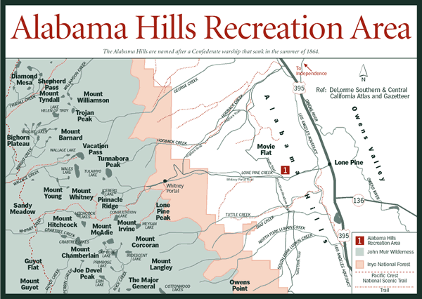
Read more about the Alabama Hills of the Eastern Sierras:
digital-desert.com/route-guide/route-02.html
www.sherpaguides.com/california/mountains/eastern_sierra/...
Press L to view on black —
All images are the property of ARDATH'S ARTISTIC ENTERPRISES©
Using these images without permission is in violation of international copyright laws (633/41 DPR19/78-Disg 154/97-L.248/2000)
NO materials may be copied, reproduced, distributed, republished, downloaded, displayed, posted or transmitted in any forms or by any means, including electronic, mechanical, photocopying, recording without written permission of ARDATH'S ARTISTIC ENTERPRISES©
Every violation will be pursued penally.
It was a very nice winter day in north Georgia. We parked at Tray Gap and hiked about a mile on the Appalachian Trail to the summit of Tray Mountain. The peak is 4,430 feet high according to the U.S.G.S topographic map. Who the hell knows how it ranks in Georgia's highest peaks. One source says seventh and another one says eighth. For more information: www.sherpaguides.com/georgia/mountains/blue_ridge/eastern...
Read more about the Alabama Hills of the Eastern Sierras:
digital-desert.com/route-guide/route-02.html
www.sherpaguides.com/california/mountains/eastern_sierra/...
Press L to view on black —
All images are the property of ARDATH'S ARTISTIC ENTERPRISES©
Using these images without permission is in violation of international copyright laws (633/41 DPR19/78-Disg 154/97-L.248/2000)
NO materials may be copied, reproduced, distributed, republished, downloaded, displayed, posted or transmitted in any forms or by any means, including electronic, mechanical, photocopying, recording without written permission of ARDATH'S ARTISTIC ENTERPRISES©
Every violation will be pursued penally.
I was searching one of my maps for interesting places to visit and Leatherwood Falls was labeled. We found the water level to be extremely low. This image is the top part of the 35 feet (11 meter) falls. For more information: www.sherpaguides.com/north_carolina/mountains/snowbird_mo...
Dan Calhoun and I hiked to the summit of Chimney Mountain. I thought we would have a better view of Tray Mountain but the summit was tree covered. There was a very light dusting of snow present in shady places. For more information:
en.wikipedia.org/wiki/Tray_Mountain_Wilderness
www.sherpaguides.com/georgia/mountains/blue_ridge/eastern...
A nice old vintage watch. It sure has been used. Somehow I like the looks of this watch.
It is a Enicar Worldtimer or as it officially is named Enicar Guide.
In it is an in-house caliber 1126.
This Enicar has the Sherpa case, which is a nice design.
Hightower Bald is the fourth highest peak in Georgia. It is also one of the most remote. There are no trails to it. We hiked 8.49 miles round trip with a cumulative vertical climb of 3,482 feet. I expected the name "bald" would at least yield a nice view or something. Instead we found the last quarter mile of summit ridge to be thickly overgrown with head high blackberries and hazelnut shrubs. The summit is covered in a shrubby mess. I had to climb a tree just to get a view. For more information: www.sherpaguides.com/georgia/mountains/blue_ridge/eastern...
An old pioneer cabin at Grayson Highlands State Park in the mountains of SW Virginia, close to the Appalachian Trail and Mt.Rogers.
not yet there to the 3 creeks and the 3 big falls at Three Forks confluence -- just a stopping point and simple creek crossing on the Three Forks trail...
----------
Holcomb Creek, Overflow Creek and Big Creek meet at Three Forks to form the West Fork of the Chattooga River
----------
www.secretfalls.com/hiking/show/7-three-forks-trail
www.maxtrails.com/trails/1002408_Three_Forks_Trail_Georgi...
www.ajc.com/travel/content/travel/destinations/ganorth/st...
www.jjanthony.com/waterfalls/falls/threeforks.html
www.sherpaguides.com/georgia/mountains/blue_ridge/eastern..
-----------
on Google map - maps.google.com/maps?t=h&q=34.968333,-83.213333&i...
Hightower Bald is the fourth highest peak in Georgia. It is also one of the most remote. There are no trails to it. We hiked 8.49 miles round trip with a cumulative vertical climb of 3,482 feet. I expected the name "bald" would at least yield a nice view or something. Instead we found the last quarter mile of summit ridge to be thickly overgrown with head high blackberries and hazelnut shrubs. The summit is covered in a shrubby mess. I had to climb a tree just to get a view. For more information: www.sherpaguides.com/georgia/mountains/blue_ridge/eastern...
A nice old vintage watch. It sure has been used. Somehow I like the looks of this watch.
It is a Enicar Worldtimer or as it officially is named Enicar Guide.
In it is an in-house caliber 1126.
This Enicar has the Sherpa case, which is a nice design.
A nice old vintage watch. It sure has been used. Somehow I like the looks of this watch.
It is a Enicar Worldtimer or as it officially is named Enicar Guide.
In it is an in-house caliber 1126.
This Enicar has the Sherpa case, which is a nice design.
A nice old vintage watch. It sure has been used. Somehow I like the looks of this watch.
It is a Enicar Worldtimer or as it officially is named Enicar Guide.
In it is an in-house caliber 1126.
This Enicar has the Sherpa case, which is a nice design.
A nice old vintage watch. It sure has been used. Somehow I like the looks of this watch.
It is a Enicar Worldtimer or as it officially is named Enicar Guide.
In it is an in-house caliber 1126.
This Enicar has the Sherpa case, which is a nice design.
A nice old vintage watch. It sure has been used. Somehow I like the looks of this watch.
It is a Enicar Worldtimer or as it officially is named Enicar Guide.
In it is an in-house caliber 1126.
This Enicar has the Sherpa case, which is a nice design.
A nice old vintage watch. It sure has been used. Somehow I like the looks of this watch.
It is a Enicar Worldtimer or as it officially is named Enicar Guide.
In it is an in-house caliber 1126.
This Enicar has the Sherpa case, which is a nice design.
Mani Rimdu is a 19-day festival celebrated by Buddhists in the Himalayas to mark the founding of Buddhism by Guru Rinpoche Padmasambhava.
Annapurna Base Camp trek is one of the most popular and finest trekking trails in the Annapurna region of Nepal, and it's often considered one of the best trekking experiences in the country. Here are some key highlights and information about this trek:
Stunning Scenery: The trek offers breathtaking views of the Annapurna mountain range, including Annapurna I, Annapurna South, Machapuchare (Fishtail), and Hiunchuli, among others. The scenery varies from lush forests and terraced fields to alpine meadows and high mountain landscapes.
Cultural Experience: Along the trek, you'll have the opportunity to interact with local communities, including Gurung and Magar villages. This provides a chance to experience the unique culture, traditions, and hospitality of the local people.
Varied Terrain: The trek takes you through a range of terrain, from subtropical forests to rhododendron-filled hillsides to glacial moraines. This diversity in landscapes makes the trek more interesting and visually appealing.
Moderate Difficulty: While the trek is challenging in parts, it is generally considered to be of moderate difficulty. It's accessible to trekkers with a reasonable level of fitness and experience, and the teahouses along the route provide comfortable accommodation and meals.
Permits: You'll need two permits to trek to Annapurna Base Camp: the Annapurna Conservation Area Permit (ACAP) and the Trekkers' Information Management System (TIMS) card. These permits are essential to enter and trek in the Annapurna region.
Duration: The trek usually takes around 7 to 14 days, depending on your starting point and pace. You can customize the itinerary to fit your preferences and available time.
Best Time to Trek: The best time for the Annapurna Base Camp trek is during the spring (March to May) and autumn (September to November) seasons when the weather is generally stable, and the skies are clear.
Safety Precautions: It's essential to be prepared for altitude sickness, as the trek takes you to altitudes over 4,000 meters. Acclimatization days and staying hydrated are crucial for a safe trek.
Guides and Porters: While it's possible to trek independently, many trekkers choose to hire local guides and porters to enhance their experience and ease the physical load.
The Annapurna Base Camp trek offers a memorable adventure through some of Nepal's most stunning natural landscapes and provides an opportunity to immerse yourself in the rich culture of the region. It's no wonder that it's considered one of the best trekking experiences in Nepal and a must-do for outdoor enthusiasts and nature lovers.
Alabama Hills outside Lone Pine from Horseshoe Meadow Rd.
The rock formations were recently figured to be from the same source as the Sierras, that is granite and faulting, but the weathering down in the valley rounded them instead of splintering them like the rocks higher up. They were covered with soil and moisture originally and also stained by the oxidation of the iron in the rock. Most of the time people just pass them off as volcanic because they certainly look like they oozed out of something. Decent description online here.
www.sherpaguides.com/california/mountains/eastern_sierra/...
Oh, and they're called the Alabama hills because Southern sympathizers during the Civil war were mining gold out here and heard about the victories of the Confederate ship Alabama and decided to name their claims after it. The name stuck for the whole region.
The viewpoint on Trek offers incredible Himalayan views. Ghorepani Poon Hill trek is undoubtedly one of the best things to do hiking in Nepal.
Location: Poon Hill, Ghorepani
Waiting to board the Cumberland Queen Ferry for a visit to Cumberland Island. For more information on Cumberland Island, www.sherpaguides.com/georgia/coast/southern_coast/cumberl...
Trekking to the region where Mount Everest lies is incredibly tough but fulfilling. Having said that, getting yourself the service of a guide and porter for your Everest Base Camp Trek or any Everest-related trek
significantly improves your safety and overall experience at these high altitudes. Furthermore, it's worth noting that solo trekking is no longer allowed in Nepal, making hiring a guide and porter a mandatory requirement. Below, we provide a guide on hiring a guide and porter for your Everest-related journeys.
For more details
mountainrocktreks.com/blog/hiring-porter-and-guide-in-eve...
Address- Z Street - Thamel, Kathmandu, Nepal
Phone- +977 1 4701233
Mobile, WhatsApp & Viber- +977 9849023179 (Dipak Pande)
Email- info@mountainrocktreks.com
Website- www.mountainrocktreks.com
#Thamel #Moonlighthotel #ramadaencore #hotelmoonlightthamel #paknajol #zstreet #mountainrocktreks #MRT202 #Guide #porter #everestregion #solotrekking #grouptrekking #everestbasecamp #gokyovalley #everestpasses #highpasstrek #guideservice #porterservice #everestclimbing #sherpaguides #sherpavillage #lukla #everest
Climbing Ama Dablam in spring (April-May) or autumn (September-November) is a serious undertaking that draws expert mountaineers. This famed Himalayan peak requires advanced technical ability as it involves both ice and rock climbing on very steep, exposed pitches. In spring, you’ll face more stable weather but deeper snow, while in autumn, there will be less snow but with potentially higher winds. Both seasons require careful acclimatization and logistical organization.
Here is more detailed information on How to Climb Ama Dablam in spring and Autumn:
mountainrocktreks.com/blog/ama-dablam-challenges-how-to-c...
Address- Z Street - Thamel, Kathmandu, Nepal
Phone- +977 1 4701233
Mobile, WhatsApp & Viber- +977 9849023179 (Dipak Pande)
Email- info@mountainrocktreks.com
Website- www.mountainrocktreks.com
#AmaDablamClimb #NepalMountaineering #HimalayanAdventure #SpringClimbing #AutumnClimbing #ExpeditionPrep #MountaineeringTraining #HighAltitudeClimbing #SherpaGuides
#dipak #mountainguide #Thamel #paknajol #Zstreet #mountainrocktreks