View allAll Photos Tagged SYSTEMS
An artist's concept shows the Orion Multipurpose Crew Vehicle and future destinations for human exploration beyond Earth orbit: the moon, an asteroid and Mars.
NASA has selected the design of a new Space Launch System that will take the agency's astronauts farther into space than ever before, create high-quality jobs here at home, and provide the cornerstone for America's future human space exploration efforts. The booster will be America’s most powerful since the Saturn V rocket that carried Apollo astronauts to the moon and will launch humans to places no one has gone before.
The SLS will carry human crews beyond low Earth orbit in the Orion Multi-Purpose Crew Vehicle. The rocket will use a liquid hydrogen and liquid oxygen fuel system, where RS-25D/E engines will provide the core propulsion and the J-2X engine is planned for use in the upper stage.
Image credit: NASA
Original image:
www.nasa.gov/exploration/systems/sls/multimedia/gallery/S...
More about SLS:
www.nasa.gov/exploration/systems/sls/index.html
Space Launch System Flickr photoset:
www.flickr.com/photos/28634332@N05/sets/72157627559536895/
_____________________________________________
These official NASA photographs are being made available for publication by news organizations and/or for personal use printing by the subject(s) of the photographs. The photographs may not be used in materials, advertisements, products, or promotions that in any way suggest approval or endorsement by NASA. All images used must be credited. For information on usage rights please visit: www.nasa.gov/audience/formedia/features/MP_Photo_Guidelin...
Tucson Mountain District (West)
Bajada Loop Drive - Valley View Trail
Saguaro National Park in southern Arizona is part of the National Park System in the United States. The park land consists of two distinct areas—the Tucson Mountain District (TMD) west of the city of Tucson and the Rincon Mountain District (RMD) east of the city—that preserve Sonoran Desert landscapes and diverse fauna and flora, including the giant saguaro cactus. The volcanic rocks on the surface of the TMD differ greatly from the surface rocks of the RMD; over the past 30 million years, crustal stretching associated with the Basin and Range displaced rocks from beneath the Tucson Mountains to form the Rincon Mountains. Uplifted, domed, and eroded, the Rincon Mountains remain significantly higher and wetter than the Tucson Mountains, and the higher elevations of the RMD support plant and animal populations that do not exist in the TMD.
Earlier residents of and visitors to the lands in and around the park before its creation included the Hohokam, Sobaipuri, Tohono O'odham, Apaches, Spanish explorers, missionaries, miners, homesteaders, and ranchers. In 1933, President Herbert Hoover, using the power of the Antiquities Act, established the original park as Saguaro National Monument. In 1961, President John F. Kennedy added the TMD and re-named the original tract the RMD. Congress combined the TMD and the RMD to form the national park in 1994.
Hiking on the park's 165 miles (266 km) of trails and sightseeing along loop drives near the park's visitor centers are popular activities. Both districts have picnic areas and allow bicycling and horseback riding on selected roads and trails. The TMD forbids overnight camping, but the RMD supports limited wilderness camping. Both districts offer ranger-led walking tours and other educational programs.
(Wikipedia)
Der Saguaro-Nationalpark befindet sich bei Tucson, Arizona im Südwesten der USA. Der Park liegt in der Sonora-Wüste, die sich bis weit nach Mexiko erstreckt, und gilt als eine der schönsten und artenreichsten Regionen dieser Wüste. Eine herausragende Pflanze hat dem Park seinen Namen gegeben: der Kandelaberkaktus Carnegiea gigantea (engl. Saguaro).
Seit 1933 ist das Gebiet als National Monument geschützt. Der Nationalparkstatus wurde am 14. Oktober 1994 vergeben. Im Jahr 2013 kamen laut National Park Service 678.261 Besucher in das Schutzgebiet, das sich über knapp 370 km² erstreckt.
Der Saguaro-Nationalpark besteht aus zwei Teilgebieten, die am westlichen bzw. östlichen Rand der Stadt Tucson im südöstlichen Arizona liegen. Der kleinere Westteil enthält ausgedehnte Bestände der Kandelaberkakteen. Die hügelige Ebene liegt etwa 800 Meter über dem Meeresspiegel. In den Tucson Mountains wird eine Höhe von 1418 m erreicht. Der östlich gelegene Distrikt erhebt sich aus der Ebene bis zum Mica Mountain (2641 m), dem höchsten Gipfel in den Bergen der Rincon Mountains, etwa 40 Kilometer östlich von Tucson.
Der Saguaro-Nationalpark liegt im östlichen Teil der Sonora-Wüste und ist Teil des Arizona Upland. Die Temperaturen übersteigen im Sommer tagsüber oft 40 °C im Schatten, während es abends auf durchschnittlich 22 °C abkühlt. Die mittleren Temperaturen liegen im Winter bei 19 °C am Tag und 4 °C in der Nacht. Die durchschnittliche Jahresniederschlagsmenge liegt unter 300 mm.
Mehr als 1000 Pflanzenarten sind im Saguaro-Nationalpark beheimatet. Außer den riesigen Saguaros sind hier Cylindropuntia-Arten und Ferocactus wislizeni verbreitet, aber auch bunte Blumen, wie Lupinen und Goldmohn. Weitere typische Bewohner der Wüstenebene sind die großen, grünen Mesquite-Sträucher und der Fouquieria splendens, dessen lange, dünne Stämme oft wie abgestorben aussehen, aber die meiste Zeit rote Blüten tragen. Kiefern und Wacholder sind in den Bergen zu Hause.
(Wikipedia)
This former motor vehicle factory was built in 1917 by Wallis, Gilbert and Partners, in collaboration with Truscon, for Tilling-Stevens Ltd. It is an example of a factory designed using the Kahn Daylight System. The various sheds which adjoin the factory building to the south are not of special interest.
Reasons for Designation
The former Tilling-Stevens factory, 1917 by Wallis, Gilbert and Partners, in collaboration with Truscon, is designated at Grade II for the following principal reasons: * Historic interest: the building is the earliest surviving by the practice of Wallis, Gilbert and Partners, the foremost factory architects of the inter-war period; it is also one of few surviving examples of their early Daylight factories not to have undergone significant alteration; * Technical interest: the building is one of few surviving examples of a group of English factories built using the Kahn Daylight System, an adaptable, efficient and influential system of factory building, developed in America for the construction of automotive factories; * Architectural interest: the front elevation of this imposing building employs the compositional devices and decorative motifs which became synonymous with the work of Wallis, Gilbert and Partners; the powerful rationality of its other elevations expresses the modern approach to industrial architecture that its design, construction and layout embodies.
History
In 1916 Thomas Wallis (1872-1953) founded the architectural practice of Wallis, Gilbert and Partner (becoming Wallis, Gilbert and Partners the following year). In the early years of the practice it worked in close collaboration with Trussed Concrete Steel Limited (Truscon). Truscon's proprietary system of concrete reinforcement had been developed by the Kahn family, who had set up Truscon to exploit the system in America; an English branch of the company formed in 1907. In America the Kahn system had been applied to the creation of a particular model of factory design which was based on a regular grid of column, beam and slab, in which the concrete frame was fully exposed, and the external walls were glass-filled, it was called the 'Kahn Daylight System' of factory design. The best known and most influential American example is Henry Ford's Highland Park Ford Plant, Michigan, designed and built in 1908 by Albert Kahn. Truscon built several Daylight factories in Britian prior to the partnership with Wallis, Gilbert and Partners (including three in Scotland), but the only English one known to survive in anything like original condition is Enterprise House, Hayes, of 1912, listed Grade II.
Together, Wallis, Gilbert and Partners and Truscon designed and constructed of a number of Daylight factories in England, of which the Tilling-Stevens factory is the earliest surviving. Wallis Gilbert and Partners went on to great success as an architectural practice, designing many factories and commercial buildings in the interwar period. One of their best known works is the Grade II* listed former Hoover Factory (1932-35) in Ealing.
Tilling-Stevens Ltd was formed in 1915 after WA Stevens, inventor of the petrol-electric motor, met Richard Tilling of Thomas Tilling Ltd, London's oldest omnibus operator (established 1847). The men recognised the potential for petrol-electric transmission in motorised buses, and the companies went into partnership together, manufacturing their own vehicles. New premises were added to Stevens' Maidstone works (known as the Victoria Works) in 1912, and following the formation of Tilling-Stevens Limited the works were enlarged again with the construction of the Wallis Gilbert and Partners factory in 1917 to accommodate production for war requirements.
The original design for the factory was a five-storey hollow rectangle, with a central, glazed, single-storey space within the well, which would contain part of the assembly shop. It was designed to be built in stages, with the south and west sides of the rectangle shown on the plans as 'future extension' (J Skinner 1997, 50). It is thought likely that the decision only to build the north and east sides of the rectangle was taken at an early stage, as the attic storey is centred over the existing front elevation. The factory was designed so as to accommodate all the various manufacturing processes in a downward flow through the building, each level being linked by electric lifts. Power was supplied to work stations by shafted over-head motors suspended from the beams.
In the early 1950s Tilling-Stevens was taken over by the Rootes Group, which was itself taken over in the mid-1960s by Chrysler (UK) Ltd; the Tilling-Stevens factory closed in 1975.
Details
The factory is constructed of a regular reinforced concrete grid, expressed throughout the exterior of the building; the front elevation, also of concrete, is dressed to present a classically-styled composition to the street.
MATERIALS: the building is composed of a grid of exposed horizontal and vertical reinforced concrete members, which divide the building into 20' by 20' bays; on the outer faces of the building the bays are in-filled with panels of red brick and glazing. The original windows were multi-light steel casements however these have almost universally been replaced with uPVC casements.
PLAN: the building is five storeys high with a small attic storey. The factory floor is L-shaped in plan; the core is 3 bays wide by 16 bays deep, with a perpendicular wing to the rear, 3 bays wide by 3 deep, extending southwards. Another 3 bay by 3 bay wing projects to the north, which contains the main goods lift and stair; this was where the services and amenities for the building were housed. The front of the building is an additional two bays wide to the north, providing a vehicular access at street level. A roadway runs from this entrance, through the centre of the northerly service wing (where there is a weigh bridge), and down the side and rear of the building. To the rear there is a projecting stair and lift tower, and to the south there is a second projecting lift tower; this is later in date, but appears to use the same construction system. There is a third internal fire escape stair on the south side of the building which exits onto St Peter's Street at the front.
EXTERIOR: with the exception of the front, all elevations of the building are without architectural embellishment and form a regular pattern of concrete grid, brick, and glass. The concrete grid is also expressed on the front elevation, however here the concrete is also used decoratively to shape the elevation into a classical composition. There is a heavy cornice over the fourth storey, with recessed ribbing and nail-head corner stops; the fifth storey is treated as a classical attic, having smaller windows and a much plainer and shallower cornice above. The true attic storey is three bays wide, central to the elevation and set back from the front. The bays to the far left and right of the elevation are treated as towers, defined by slightly projecting pilaster-like verticals to either side. The 'capitals' of these pilasters take the form of a circular disk, flanked by triglyph-like elements. At ground floor there is a pedestrian and vehicular entrance/exit to either side of the elevation. These openings are framed by wide, flat, unmoulded architraves and above each of the vehicular openings is a framed panel (which once bore the name of the company) with a stylised tassel motif to either side. This panel with tassels motif is repeated within the parapet above the attic storey.
The exterior of the building is generally little altered, the most notable exception being the replacement of the windows. The largest windows to the front were originally 54-light windows, they are now 12-light windows, those to the sides and rear were mostly 45-light windows, these are now 8-light windows. On the front elevation a doorway has been inserted into the left-hand of the three central bays to give access into a site office from St Peter's Street.
INTERIOR: the interior is utilitarian; at each storey concrete pillars support beams and joists which support the floor above. The pillars get progressively smaller in cross-section at each storey up. Circular holes are cast into the joists, through which a conduit carrying electrical cable ran; in some places slots are cast into beams and joists to carry the motors which were suspended overhead, providing power to the factory machinery. The factory floors, which would have been completely open, are now divided into units with concrete block walls built between pillars. Fixtures and fittings which may have been associated with the service and amenity block (which included an office, boiler house, first-aid rooms, lavatories and rest rooms) do not survive.
Sources
Books and journals
Collins, P, Stratton, M , British Car Factories from 1896: A complete historical, geographical, architectural and technological survey, (1993)
Skinner, J, Form and Fancy: Factories and Factory Buildings by Wallis Gilbert and Partners, 1919-1939, (1997)
Souster, E G W , The Design of Factory and Industrial Buildings, (1928), 142-148
'The Architects' Journal' in The Utility of Reinforced Concrete, (26 January 1928), 100-107
The Llwyngwril Systems Guppy was a high performance speeder bike. It was aimed at pilots who found the power of the Daley-Harleyson WD-40 "Whale" underwhelming and insufficient.
The bike was yet another huge Watt & Pritney turbojet engine, with a seat and some bodywork. Steering was achieved somehow, eventually, after a long while and probably with the aid of telekinesis. Inspiration for the bike's name came from the Super Guppy series of aeroplanes.
************************************
This model uses two more of the six black fans that I bought from Bricklink. Two more left to use, plus a blue one!
Italien / Belluno - Tofane
Hike around the Tofana di Rozes
Wanderung um die Tofana di Rozes
Tofane is a mountain group in the Dolomites of northern Italy, west of Cortina d'Ampezzo in the province of Belluno, Veneto. Most of the Tofane lies within Parco naturale delle Dolomiti d'Ampezzo, a nature park.
Peaks
The highest peaks of the Tofane group are Tofana di Mezzo (3,244 m (10,643 ft)), Tofana di Dentro (3,238 m (10,623 ft)), and Tofana di Rozes (3,225 m (10,581 ft)). Tofana di Mezzo is the third highest peak in the Dolomites, after Marmolada (3,343 m (10,968 ft)) and Antelao (3,262 m (10,702 ft)). All three peaks were first climbed by Paul Grohmann along with local mountain guides, in 1863 (Tofana di Mezzo - with Francesco Lacedelli), 1864 (Tofana di Rozes - with Francesco Lacedelli, Angelo Dimai and Santo Siorpaes) and 1865 (Tofana di Dentro - with Angelo Dimai).
Geology
The Dolomites were formed during the Cretaceous Period, approximately 60 million years ago, due to the collision of the African and European continents. The Tofane is largely formed from the Upper Triassic rock Dolomia principale. The strata are perceptibly folded, and the mountains are finally formed by wind, rain, glaciers and rivers.
Tourism
Access
A cable lift system (Freccia nel Cielo, "Arrow in the sky") goes from Cortina almost to the top of Tofane di Mezzo. There is only a short walk from the top cable car to the summit. Alternatively the via ferratas VF Punta Anna and VF Gianna Aglio can be used to reach Tofane di Mezzo.
Cabins (rifugi)
Some of the cabins in the Tofane are the Rifugio Angelo Dibona (2,083 m (6,834 ft)), the Rifugio Giussani (2,580 m (8,465 ft)), the Rifugio Duca d'Aosta (2,098 m (6,883 ft)), and the Rifugio Pomedes (2,303 m (7,556 ft)).
Via ferratas
The via ferratas of Tofane are VF Punta Anna and VF Gianna Aglio on Tofana di Mezzo, VF Lamon and VF Formenton on Tofana di Dentro, and VF Giovanni Lipella on Tofana di Rozes, where there also are tunnel systems from World War I.
History
During the First World War, the Tofane was a battlefield of the Italian Front for clashes between the Italian and Austro-Hungarian forces. The front lines went through the mountains.
At the 1956 Winter Olympics, Mount Tofane hosted five of the six alpine skiing events. It regularly hosts women's speed events on the World Cup circuit, and hosted the World Championships in 2021. The men's 1956 downhill and the current women's World Cup races are on the Olimpia delle Tofane ski race course (often referred to as “Tofana” for short); it is famous for the Tofana Schuss, where athletes can reach speeds over 130 kilometres per hour (81 mph).
(Wikipedia)
Tofana di Rozes (3,225 metres (10,581 ft)) is a mountain of the Dolomites in the Province of Belluno, Veneto, Italy. Located west of the resort of Cortina d'Ampezzo, the mountain's giant three-edged pyramid shape and its vertical south face, above the Falzarego Pass, makes it the most popular peak in the Tofane group, and one of the most popular in the Dolomites.
History
From May 1915 to July 1916, the mountain and its surroundings was the location of fierce fighting between Italian and German, later Austrio-Hungarian, troops, as part of the Italian front in World War I.
West of the main face, and separated from the mountain by a steep and rocky gully, is the Castelletto, a narrow, long rock 700 feet high. In 1915 it was occupied by a German platoon, which, armed with a machine gun and sniper rifles, wreaked havoc on the Italian troops in the valley. They were soon replaced by Austrian soldiers, and from their strategic position they prevented any Italian plans for a push north. For the Alpini, the Italian mountain infantry specialists, retaking the Castelletto became a prime objective. Two of their climbers, Ugo Vallepiana and Giuseppe Gaspard, climbed up the Tofana to a ledge a few hundred feet above the Castelletto, but their guns were not very successful. One summer night four Alpini climbed up the Castelletto but they were discovered and shot. An attack through the gully, taking advantage of the morning fog, was also unsuccessful (machine gunners shot the advancing soldiers when the fog thinned a little), as was a massive attack from three sides in the fall of 1915. So, in February 1916 the Italians, led by Lt. Luigi Malvezzi [it], started tunneling into the Castelletto, first with hammers and chisels and then, in March, with pneumatic drills, and with teams of over two dozen men, working four six-hour shifts, they tunneled up to 30 feet per day. The steep tunnel was 500 meters long, and 2,200 cubic meters of rubble were removed. Its adit was in a "sheltered position within a natural ravine", accessed by a long ladder and thus logistically very demanding. One part of the tunnel brought them under the Austrian position, where they filled a cavern, 16 by 16 feet and 7 feet high, with 77,000 pounds of gelignite. The other led to what was to be an attack position, to be opened with a smaller batch of explosives.
On July 11, at 3:30 AM, the gelignite was exploded, with King Victor Emmanuel III and the army's chief of staff, General Luigi Cadorna, looking on. The Austrian commander was Hans Schneeberger, an orphan from Brandberg, Tyrol, who at age 19 replaced a commander who had been killed by an Italian sniper. When the explosions happened, some two dozen Austrian soldiers were killed instantly, but Schneeberger and a few survivors had rifles and grenades, and were able to repel the Italians from the edge of the crater. The attack as a whole was a failure: soldiers were to lower themselves from the Tofana to attack the Castelletto, but the explosion destroyed their ropes. To make matters worse, the explosion used up so much oxygen that Malvezzi and his men, going through the attack tunnel, passed out because of toxic gases including carbon monoxide; some of the men died. Finally, the explosion damaged the rock face on the east, sending huge boulders down the gully and killing incoming Italian soldiers. The next day, Italians had hauled machine guns up the face of the Tofana; Schneeberger sent one of his men to ask for reinforcements, which arrived that night. A few hours later the Italians attacked the relief platoon, and the Austrians withdrew to the Castelletto's northern end, and pulled their troops away altogether after a few days.[2] Malvezzi received the Military Order of Savoy.
Climbing
Most climbs start from the north, where the mountain is a relatively easy hike, or the west face, where the summit can be reached by a via ferrata. The south face, however, is a much more difficult challenge, with many of the routes being either fifth or sixth graded climbs. The mountain was first climbed in 1864 by Paul Grohmann and local hunter Francesco Lacedelli. The south face was first climbed in 1901.
Via Ferrata
A via ferrata starts at the restored entrance to the mine tunnel at the Castelletto, and leads to the summit of the mountain; along the way one finds a memorial to Giovanni Lipella,[8] an Italian soldier who died on the mountain on 15 June 1918 and was posthumously awarded the Gold Medal of Military Valour.
Cave
The Grotta di Tofana is one of only a few natural caves in dolomite rather than regular limestone. It is accessible by way of a via ferrata that starts some 40 minutes from Rifugio Dibona. The cave is some 300 meters deep, and the roof is up to 10 meters high. The cave has been quite popular with tourists, and was listed by Baedeker as "a large cavern accessible by ladders" and as an interesting visit.
(Wikipedia)
Das Dreigestirn der Tofane (italienisch Tofane, deutsch auch Tofana) gehört zu den bekanntesten und markantesten Dolomitenmassiven. Die Tofane liegen westlich von Cortina d’Ampezzo und überragen das Valle del Boite (Boitetal). Eine gewisse Bekanntheit erlangte der Name durch die Skirennstrecke Olimpia delle Tofane, 1956 Austragungsort der olympischen Herrenabfahrt.
Lage und Umgebung
Das Tofane-Massiv liegt westlich von Cortina d’Ampezzo über dem oberen Valle del Boite und ist Teil des Parco Naturale delle Dolomiti d’Ampezzo. Während die beiden höheren Gipfel Tofana di Mezzo und Tofana di Dentro ein kompaktes Massiv bilden, wirkt die südliche Tofana di Rozes einigermaßen eigenständig. Zwischen diesen Felsgiganten schneidet sich die Forcella Fontananegra (2561 m) ein. Im Westen und Norden trennt das Val Travenanzes das Gebirgsmassiv von der Fanesgruppe, im Osten das obere Valle del Boite vom Pomagnonzug (und der Cristallogruppe) und im Süden das Falzaregotal von der Nuvolaugruppe. Von Cortina gesehen ist den beiden höheren Tofane eine Wandstufe vorgelagert, die mit dem Südostgrat der mittleren Tofana eine Art „Felsenring“ bildet.
Gipfel
Das Massiv besteht im Wesentlichen aus den drei Dreitausender-Gipfeln, die allesamt beliebte Tourenziele darstellen. Alle drei rangieren unter den zehn höchsten Gipfeln der Dolomiten.
Die in der Mitte gelegene Tofana di Mezzo (auch Tofana II) ist mit einer Höhe von 3244 m s.l.m. die höchste der drei Tofane und zugleich nach der Marmolata (3343 m) und dem Antelao (3264 m) der dritthöchste Dolomitenberg.
Die Tofana di Dentro (hintere Tofana, auch Tofana III) hat eine Gipfelhöhe von 3238 m s.l.m. und bildet den nördlichsten der drei Felsriesen.
Die Tofana di Rozes (vordere Tofana, auch Tofana I) ist 3225 m s.l.m. hoch und vor allem für ihre imposante Südwand (Tofana Sud) bekannt.
Geologie
Bereits 1873 setzte sich Hermann Loretz geologisch mit dem Gebiet um die Tofane auseinander. Edmund Mojsisovics von Mojsvár lieferte mit seiner Arbeit zu den Dolomit-Riffen (1879) weitere wichtige Aufschlüsse, die Leopold Kober 1908 vertiefte.
Die Tofane werden aus mächtigem triassischem Hauptdolomit (Dachsteindolomit) aufgebaut, der leicht Richtung Norden einfällt. In den Gipfelbereichen wird er von jurassischen Kalken (früher als Lias bezeichnet) überlagert. Der Grat zwischen Tofana II und III gewährt gute Einblicke in die Schichtfolge und lässt Neokom und Oberjura erkennen, während in den untersten Bereichen ältere Gesteine wie Sandsteine, Kalkmergel und Tuffe zu Tage treten, die ein auffälliges grünes Band formen. Der Komplex von Tofana II und III wird außerdem von einer nach Westen überschlagenen Falte geprägt, deren Mächtigkeit allerdings nur die obersten 200 Meter umfasst. Nach Süden hin setzt sich diese tektonische Störung fort. Am Südgrat der Tofana II befindet sich mit dem Bus de Tofana eines der größten Felsenfenster der Alpen.
Geschichte
Die Erstbegehungen der drei Gipfel erfolgten nacheinander in den Jahren 1863 bis 1865. Paul Grohmann bestieg mit verschiedenen Führern zuerst die Tofana di Mezzo (1863), dann die Tofana di Rozes (1864) und schließlich die Tofana di Fuori (1865), allesamt von Cortina aus. Alpinistisch war in der Folge vor allem die Südwand der Tofana di Rozes von Interesse, die 1901 durch Ilona und Rolanda von Eötvös mit Führern erstmals durchstiegen wurde.
Während des Ersten Weltkriegs bildeten die Tofane eines der Zentren der Ersten Dolomitenoffensive. Die italienischen Alpini besetzten im Juli 1915 die Gipfel von Tofana II und Tofana III und versuchten von dort aus die österreich-ungarische Sperre im Travenanzestal zu erobern. Die Tofana I wurde wiederum kurzzeitig von Jägern des Deutschen Alpenkorps eingenommen. Kriegsrelikte wie Stollen und verfallene Stellungen zeugen heute noch von den erbitterten Kämpfen.
Mit den Olympischen Winterspielen 1956 in Cortina d’Ampezzo hielt der Massentourismus erstmals Einzug in die Gegend. Während die Skigebiete mit der heute noch als Weltcupstrecke genutzten Olimpia delle Tofane am Osthang von Tofana di Mezzo/Dentro entstanden, blieb die Spitze bis zum Bau der Seilbahn Freccia nel cielo (deutsch: Himmelspfeil) 1971 verschont. Davor waren bereits mehrere Klettersteige angelegt worden, die sich heute großer Beliebtheit erfreuen, darunter die Via ferrata Giuseppe Olivieri auf die mittlere Tofana (1957), die Via ferrata Giovanni Lipella auf die Tofana di Rozes (1967) und die Via ferrata Formenton auf die Tofana di Dentro.
(Wikipedia)
Die Tofana di Rozes (auch Vordere Tofana oder Tofana I) ist ein 3225 m s.l.m. hoher Berg in den Dolomiten in der italienischen Provinz Belluno. Mit ihrer berühmten Südwand bildet sie die eindrucksvollste, wenn auch niedrigste Erhebung der dreigipfeligen Tofane westlich von Cortina d’Ampezzo.
Lage und Umgebung
Die Tofana di Rozes ist der südlichste der drei Tofana-Gipfel und von der Tofana di Mezzo durch die Forcella Fontananegra (2561 m) getrennt. In diesem Bereich liegen das Rifugio Giussani und das nicht mehr bewirtschaftete Rifugio Cantore. Im Westen trennt die Forcella Bois (2331 m) den Felskoloss vom Lagazuoistock, im Westen und Norden bildet das Val Travenanzes die Grenze zur Fanesgruppe. Von Norden gesehen erscheint der Berg als dreikantige Felspyramide, nach Süden zeigt er eine der imposantesten Wände der Dolomiten, die meist als Tofana Sud bezeichnet wird. Trotz der niedrigsten Gipfelhöhe ist der Berg gerade aufgrund dieser 800 Meter hohen Südwand das bekannteste Motiv der Tofane. Im unteren Wandabschnitt liegt mit der Grotta della Tofana eine mehrere Meter tiefe Höhle, die bereits von Paul Grohmann besucht wurde.
Alpinismus
Die Erstbesteigung gelang am 29. August 1864 Paul Grohmann mit den Einheimischen Francesco Lacedelli, Angelo Dimai und Santo Siorpaes. Grohmann und Lacedelli hatten im Jahr zuvor bereits die Tofana di Mezzo erstbestiegen. Ähnlich wie bei deren Erschließung wählten sie den Anstieg aus der Forcella Fontananegra über die Nordostflanke, den heutigen Normalweg. Grohmann äußerte sich begeistert über die Aussicht vom Gipfel:
„Ich bin kein Freund davon zur Schilderung einer Aussicht zahllose Bergspitzen herzuzählen, und unterlasse dieses auch hier, unvergesslich aber bleibt mir ein Detailbild der Rundsicht: die furchtbaren Schrofen der beiden anderen Tofanaspitzen in nächster Nähe, und zwischen diesen blickt weiter hinten der Gaisl vor, die Croda rossa der Ampezzaner; nur der oberste Theil, aber dieser blutroth, ein seltsamer Contrast gegen die grauen Kalkwände der Tofana!“
Im August 1901 meisterten Ilona und Rolanda von Eötvös mit Antonio Dimai, Giovanni Siorpaes und Agostino Verzi erstmals die kolossale Südwand. Die Via Eötvös-Dimai (IV) gilt heute als eine der klassischen Routen in den Dolomiten. Die durch wuchtige Pfeiler auffällig gegliederte Wand wurde im Laufe des 20. Jahrhunderts auf fast 30 verschiedenen Routen durchstiegen. Zu den bedeutendsten gehören etwa der zweite Pfeiler (Secondo Pilastro, VI), der 1946 von Ettore Constantini und Luigi Ghedina erstmals bewältigt wurde, oder die 1952 durch Walter Bonatti und P. Contini erschlossene Via delle Tridentina (ebenfalls VI). Weitere wichtige Erstbegehungen gelangen Angelo Dibona, Walter Stößer und Attilio Tissi.
Im Ersten Weltkrieg galt die Tofana di Rozes als besonders umkämpfter Berg. Am 22. Juli 1915 nahm eine Patrouille des dritten Jäger-Regiments im Deutschen Alpenkorps im Zuge der Ersten Dolomitenoffensive den bis dahin unbesetzten Gipfel ein. Man konnte die Tofana I bis zum 18. September gegen die Italiener verteidigen.
Aufstieg
Trotz der imposanten Erscheinung ist die Tofana di Rozes – sieht man von der Seilbahn-Erschließung der Tofana di Mezzo ab – von den drei Tofana-Gipfeln am leichtesten zu ersteigen. Dem Nicht-Kletterer bieten sich für den Aufstieg zur Tofana di Rozes zwei Möglichkeiten.
Der Normalweg führt vom Rifugio Giussani (2580 m) unschwierig über geröllbedeckten Fels zum Nordwestgrat und über diesen schließlich zum Gipfel. Firnreste sind im oberen Bereich keine Seltenheit.
Eine zweite Variante bietet die 1967 eröffnete Via ferrata Giovanni Lipella (Schwierigkeit C/D). Diese wird zumeist vom Rifugio Angelo Dibona (2083 m) aus in Angriff genommen. Der Weg führt zunächst unter der mächtigen Südwand entlang zum Einstieg, wo gleich ein steiler Stollen durchquert werden muss. Danach verläuft der Steig an der Westseite des Berges Richtung Norden zu den Tre Dita (2694 m) und macht schließlich einen Knick nach Süden. Nach dem Ausstieg erreicht man den Normalweg und über diesen den Gipfel.
(Wikipedia)
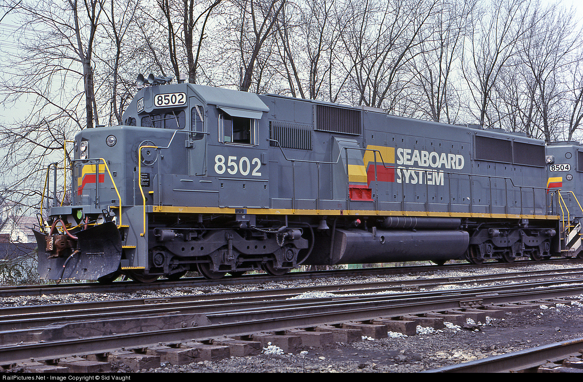
The last locomotives purchased by the L&N were SD50s, but they were all delivered in Seaboard gray. They did, however, retain some of the L&N subtleties such as nose mounted headlights and marker lights. For a kid like me in '83, they were a real shock. Seeing these big matched sets pulling exhaustingly long coal trains was the final end of the Louisville & Nashville railroad forever. They always seemed to come in sets of three and always followed by a mile of coal hoppers. I have built a Seaboard SD50 before, but it passed back into the brick long ago. I knew this time around I would have to do it right and build a 3 unit lashup of these 3500 hp brutes. I'll get back to you on that mile long string of hoppers.
A westbound Chessie System coal train rolls through Struthers, OH at the old Bridge St. crossing. That's my 1981 Chevette at the right edge of the photo.
Aberkenfig, South Wales
Lat +51.542 Long -3.593
Obtained using a 254mm Skywatcher Newtonian, Tal 2x Barlow Lens & ZWO ASI 120MC Astronomical Imaging Camera.
Captured using Sharpcap.
Processed with Registax 6 & G.I.M.P.
The Moon rises as NASA’s Space Launch System (SLS) rocket with the Orion spacecraft aboard is seen atop a mobile launcher as it rolls out of the Vehicle Assembly Building to Launch Pad 39B, Tuesday, Aug. 16, 2022, at NASA’s Kennedy Space Center in Florida. NASA’s Artemis I mission is the first integrated test of the agency’s deep space exploration systems: the Orion spacecraft, SLS rocket, and supporting ground systems. Launch of the uncrewed flight test is targeted for no earlier than Aug. 29. Photo Credit: (NASA/Joel Kowsky)
So to my annoyance, Bryan has sold all my Canon gear and bought all Nikon stuff *rolls eyes*. The reason being, is that he wants to use the awesome 14-24mm landscape lens from Nikon, and since I needed a full frame camera anyways, he bought the D700 to go along with it.
This was taken with my new 35mm f/1.4 lens from Nikon. I love the lens, but hate using the Nikon body. I only hold the camera with my right hand to take photos, and because my hands are so tiny, I can't reach any of the dials on the Nikon camera. It is meant to be held with two hands, but since I have one hand on a doll all the time.... well you get the picture...
Anyways, I've missed using a full frame camera... I hate using cropped sensors. This lens also has nicer bokeh than the Canon 35 mm f/1.4 and has more aperature blades. The bokeh is much smoother on this lens. Love the lens, but hate the body... what can you do?
Striped uniforms in general have made a huge comeback into the jail and prison system, for a variety of reasons, such as mistaking jumpsuit-clad workers or scrub-clad nurses/doctors as inmates.
These hinged maximum security cuffs feature a pick resistant wafer lock. When double locked, these are the worlds most difficult cuffs to pick. Utilizing a wafer lock that requires a separate special key, the HSS9 cannot be opened with any other handcuff key. Not even other HSS9 keys.
Norcal Waste Systems Inc. trucks prepare to depart for waste collection in San Francisco, California, U.S., on Tuesday, Nov. 17, 2009. Golden Gate Disposal & Recycling, a unit of Norcal, is San Francisco's authorized collection company serving businesses in the Financial District and contiguous neighborhoods including North Beach, South of Market, South Beach, Fisherman's Wharf and the Marina District. Photographer: Chip Chipman/Bloomberg via Getty Images
Monday night on the Space Coast as the Full Moon rises over NASA’s Space Launch System and the Orion spacecraft, ready to ride out incoming T/S Nicole.
We need to "uproot the system" - While I didn't ask the protester with the placard what precise meaning she wanted to convey, it seems obvious that we need to challenge the global corporate political system if we are to implement effective measures to combat climate change.
As part of coordinated protest action by tens of thousands of people worldwide, demonstrators took to the streets to demand urgent action to tackle the existential threat of catastrophic climate change. In London, several hundred protesters, many of them students, met in Parliament Square before marching to the Home Office. All part of the Fridays for Future campaign.
Exclusive for The Black Dot Project:
The Whoreshop! - Sarah Jeans
100% Original Creation
Available in 6 Colors.
Black | Blue | Dark | Grey | Light | Washed
Incl. Standard Clothing Layers & Appliers for:
Maitreya | Slink | Belleza
Omega System
Available @ The Black Dot Project Starts 11th April!
It is finally here and available to but now. order it here www.esemtee.bigcartel.com/
also in store at chrome and black in the next few days..
100 pre-orders are being sent out tomorrow morning so watch out for that post man!
This bus stop at the foot of the Canongate in Edinburgh has been equipped with an updated Real Time Passenger Information system which is being tested. The city and Lothian Buses introduced the city’s original RTPI system - branded BusTracker circa 2004 - but is well overdue for replacement.
To make this upload more interesting, I have added some Edinburgh transport chronology:-
Sedan chair makes first appearance in Edinburgh 1687
Edinburgh to Queen’s Ferry Road designated as turnpike road 1751
London to Edinburgh mail coach journey advertised as “10 days in summer, 12 days in winter.” 1754
Ferry Road constructed on its present line 1758
The first North Bridge completed 1772
South Bridge built 1785-1788
First wet dock (East Dock) at Leith opened 1806
John Rennie’s Musselburgh New Bridge opened 1808
First steamboat on the Forth 1812
West Dock completed 1817
Junction Bridge in Leith built 1818
Regent or Regent’s Bridge carrying Waterloo Place over Calton Road completed 1819
Trinity Chain Pier opened 1821
First regular steamship service between Leith and London 1821
Union Canal opened 1822
Second Cramond Brig opened 1824
Leith Dock Commission established 1826
Telford’s Pathhead (or Lothian) Bridge over Tyne Water built 1827-1831
George IV Bridge built 1827-1836
The Mound completed 1830
Glenesk Viaduct over River North Esk on Edinburgh & Dalkeith Railway completed 1831
Telford’s Dean Bridge completed 1832
Horse drawn passenger service inaugurated on E&DR from St Leonards 1832
New Western Approach (later Johnston Terrace) opened 1836
Granton Pier, originally Victoria Jetty, opened 1838
Edinburgh & Glasgow Rly opened from Haymarket to Glasgow via Falkirk 1842
Railway opened from Scotland Street to Trinity 1842
Granton to Burntisland ferry service opens 1844
Rival schemes put forward for atmospheric railways between Edinburgh and Leith 1845
North British Railway opens to Berwick-upon-Tweed 1846
E&GR extended from Haymarket to Waverley 1847
Scotland Street tunnel and Canal Street station opened 1847
Musselburgh (town centre) station opened 1847
Last mail coach run from Edinburgh to London 1847
Caledonian Railway opened from Carlisle to Lothian Road station via Carstairs 1848
Edinburgh & Glasgow Railway purchase the Union Canal 1848
First trains between Edinburgh and Hawick 1849
Edinburgh and Bathgate Railway opened 1849
Edinburgh and Northern Railway introduce train ferry service for freight wagons between Granton and Burntisland 1851
Victoria Dock at Leith opened 1852
West Pier at Leith opened 1852
Peebles Railway opened 1855
Melville Drive opened 1859
Cockburn Street built to improve access to Waverley from the Old Town 1859-1864
GNR, NER and NBR introduce common pool of passenger carriages (East Coast Joint Stock) on East Coast route 1861
NBR complete Waverley Route to Carlisle 1862
Winchburgh railway accident, 17 killed, 1862
East Coast companies introduce Special Scotch Express Edinburgh to London King’s Cross (later the Flying Scotsman) 1862
Edinburgh & Glasgow Railway taken over by NBR 1865
NBR divert Granton trains via Abbeyhill Jcn and Leith Walk 1868
Ratho/Dalmeny branch railway (1866) extended to South Queensferry 1868
CR open Cleland and Midcalder cut off 1869
NBR open Abbeyhill and Junction Road stations 1869
Albert Dock opened 1869
Tramways Act 1870
CR replace Lothian Road station with new terminus slightly further north and rename it Princes Street 1870
Portobello Pier opened 1871
Through trains to Glasgow via Bathgate 1871
First horse trams (Haymarket to Bernard Street (Leith) started by Edinburgh Street Tramways Co 1871
Penicuik Railway opened 1872
NBR introduce first sleeping car service in GB between Glasgow, Edinburgh and London 1873
Colinton New Bridge opened c.1874
Balerno branch railway opened 1874
Victoria Swing Bridge opened at Leith 1874
Tramway opened from Waterloo Place to Portobello 1875
Through trains to St Pancras via Waverley Route and Midland Railway’s new Settle and Carlisle Line 1876
CR start passenger service to Leith 1879
Edinburgh Dock opened 1881
Forth Bridge Railway Company formed by NBR/NER/GNR/MR 1881
Edinburgh Street Tramways Co trial steam tramway engines on Portobello route 1881/2
Forth Bridge construction begins 1883
Roads and Bridges Act ends turnpike roads system and tolls 1883
South Suburban railway opened 1884
Galloway Saloon Steam Packet company formed 1886
Galloway steamers build wooden pier at South Queensferry town harbour 1886
First issues of Murray’s monthly Edinburgh timetable diaries 1886
NBR open new and improved station at Portobello 1887
Belford Bridge opened 1887
NBR open Craiglockhart station 1887
First cable tram route (Edinburgh Northern Tramways Co, Hanover St to Goldenacre) 1888
Forth Bridge and connecting railways opened 1890
ENTCo open Stockbridge cable route from Frederick Street to Comely Bank 1890
CR propose railway under Princes Street and Calton Hill to Leith 1890
CR and NBR both open temporary Exhibition stations to serve Edinburgh Exhibition of the Arts, Sciences and Industries 1890
NBR open Easter Road and Piershill stations 1891
Waverley expansion 1892-1902
Lessee of Edinburgh tramways (exc Leith) changes to Edinburgh & District Tramways Co in 1894
Second Princes Street Station opened by CR 1894
CR open their Barnton branch from Craigleith to Cramond Brig (in 1903 renamed Barnton) 1894
NBR open resited Haymarket MPD west of Russell Road 1894/5
The new Haymarket (South) tunnel completed 1895
NBR open Powderhall station 1895
First motor car driven through Edinburgh 1896
Burgh of Portobello absorbed by Edinburgh 1896
Second (the present) North Bridge opened 1897
Booking Hall opened at Waverley 1897
NBR open second Calton Tunnel 1897
Turnhouse station opened 1897
New swing bridge opened at Bernard Street replacing the earlier bridge 1898
NBR open new “suburban station” at Waverley 1898
Norman MacDonald’s Edinburgh Autocar Company introduced motor wagonette service GPO to Haymarket 1899
Edinburgh & District Tramways start their first cable trams 1899
NBR acquires former Waterloo Hotel as head office 1899
Dalry Road station opened by CR 1900
Jeffrey Street footbridge over east end of Waverley opened 1900
First Sunday trams 1901
NBR open branch line to Corstorphine 1902
First pedestrian fatality as a result of being knocked down by motor vehicle in Edinburgh 1902
Bonnington Bridge built replacing 1812 structure 1902/3
NBR open Leith Central station 1903
Driving licences introduced 1903
Musselburgh & District Electric Light & Traction Co. Ltd open tramway from Joppa to Levenhall 1904
Imperial Dock opened 1904
First Leith Corporation electric trams 1905
Scottish Motor Traction Co Ltd starts first motor bus service Mound to Corstorphine 1906
Last horse tram (Tollcross to Colinton Rd) 1907
John Croall and Sons introduce first motor taxis in Edinburgh 1907
Last extension of cable tramway network in Edinburgh - the Broughton St to Canonmills line 1908
NBR open Newtongrange station 1908
NBR open temporary station at Balgreen to serve Scottish National Exhibition at Saughton Park 1908
Hailes Platform on CR Balerno branch opened 1908
Musselburgh tramway extended from Levenhall to Port Seton 1909
EDT open electric tramway Ardmillan Tce to Slateford 1910
NBR introduce summer Lothian Coast Express from Glasgow Queen Street to Gullane/North Berwick/Dunbar 1912
NBR open Scotland’s first Control Centre, 1913
NBR open carriage sidings at Craigentinny 1914
Ratho train crash kills 12, 1917
Edinburgh Corporation start running trams directly 1919
Corporation starts first bus tours 1919
NBR take over working of the Queensferry Passage 1920
Edinburgh absorbs Cramond, Corstorphine, Colinton, Leith and Liberton, 1920
Corporation start first regular bus services 1920
Saughton station closed 1921
First ECT electric trams 1922
Tramway on Princes Street electrified 1922
ECT introduce first double deck buses (open top) 1922
Railway grouping 1923
Last cable trams (the Portobello route) withdrawn 1923
Edinburgh Corporation open Portobello Power Station 1923
ECT tracks at Joppa linked up with those of the Musselburgh company 1923
Marchmont Circle electric tram service starts 1924
Tramway extended from Seafield to King’s Road 1924
Five killed when two trains collide at Haymarket 1924
Murrayfield Stadium opened 1925
ECT open Gorgie tram depot 1925
LNER withdraw train service to Trinity and Granton 1925
George Street tramway opened 1925
First night bus services introduced by ECT 1925
Edinburgh Licensed Hackney Carriage Association 1925
Tramway extension opened to Colinton 1926
ECT open Central Garage in former Industrial Hall at Annandale Street 1926
SMT open booking and enquiry office at 45 Princes Street 1926
SMT commence through bus service to Glasgow 1926
Maybury Road opened 1927
LMS relaunch their premier Euston- Glasgow/Edinburgh service as the “Royal Scot” 1927
Edinburgh-Glasgow New Road built 1927-32
Edinburgh Corporation Tramways becomes Edinburgh Corporation Transport 1928
First traffic lights in city at Broughton St/York Pl junction 1928
Levenhall to Port Seton tramway abandoned 1928
LNER introduce third class sleeping cars 1928
LNER loco 4472 “Flying Scotsman” hauls first non stop King’s Cross to Edinburgh train service 1928
Tramway extended from Corstorphine to Drum Brae 1928
Thomson’s Tours start coach services to London 1928
SMT open New Street bus garage 1929
Railway companies invest in SMT 1929
Telford Road opened 1929
Last trains to South Queensferry Halt 1929
Tram accident at Liberton Brae 1929
LNER close Turnhouse, Winchburgh, Gogar, Kirkliston and Leith Walk stations 1930
ECT open tramway extension to Stenhouse 1930
Road Traffic Act 1930
SMT starts extended tours of several days 1931
Bowens of Musselburgh sell their bus services to SMT 1931
First edition of The Highway Code published 1931
Last trains to Aberlady and Gullane 1932
LNER withdraw passenger services from Glencorse branch 1933
ECT introduce first closed top double decker 1933
Moderne style Southern Motors garage at Causewayside c.1933
Two custom built car ferries introduced at Queensferry 1934
LNER open Balgreen Halt 1934
LMS open East Pilton Halt 1934
Driving tests introduced 1935
Tramway extended from Braids to Fairmilehead 1936
SMT concentrate departures at Saint Andrew Square 1936
Corporation tours stance opened at Waverley Bridge 1936
The Maybury Roadhouse opened 1936
Final tram extension to Maybury 1937
LNER Edinburgh to Glasgow train collides with another stationary train at Castlecary killing 35, 1937
LMS open House O’ Hill Halt on Barnton branch 1937
LNER introduce The Coronation streamlined express passenger train between King’s Cross and Edinburgh and vv 1937
LNER withdraw Granton/Burntisland ferry 1940
SMT bus inbound from Port Seton crashes head on into tramcar on Portobello Road, killing five bus passengers 1941
Dalkeith branch passenger service withdrawn 1942
Western breakwater at Leith completed 1942
Last trains to Colinton and Balerno 1943
ECT restarts city tours after the war 1946
First BEA flights to London (using Northolt) 1947
Last trains to North Leith 1947
Forth Road Bridge Order approves construction of bridge 1947
ECT start Airport bus service (initially under contract to BEA) 1947
Peak year for tram passenger numbers (nearly 193m) 1947
Railways nationalised 1948
Washout of East Coast Main Line in Berwickshire 1948
SMT nationalised 1949
BEA move booking office and town terminal to 133 George Street 1950
Third car ferry introduced on Queensferry Passage 1950
New Hailes station closed 1950
BR open Easter Road Park Halt for arriving football specials 1950
Last trains to Barnton and Penicuik 1951
Last trains call at Drumshoreland, Curriehill and Ratho 1951
SMT start hourly express coach service to Glasgow 1951
Northern Roadways start overnight service to London 1951
Forth Ferries run short lived car ferry service between Granton and Burntisland 1951/2
Corporation resolves to abandon tramways completely within three years 1952
Corporation permits external adverts on trams and buses 1952
Last passenger trains to Leith Central 1952
First international flights from Turnhouse Airport (to Dublin) 1952
ECT close Gorgie tram depot 1953
BR introduce summer weekly “Starlight Special” overnight trains Waverley to London Marylebone @ 70/- return 1953
BEA Edinburgh to London flights move from Northolt to Heathrow 1954
Last trams to Portobello, Musselburgh and Levenhall 1954
Longstone bus garage opened by ECT 1955
Leith Dock Commission cease to open Bernard Street swing bridge to navigation 1955
Millerhill station closed 1955
Withdrawal of Colinton trams 1955
British Transport Historical Records open office in Edinburgh 1955
Remaining Glasgow trains via Bathgate withdrawn 1956
Fourth car ferry joins Queensferry Passage 1956
New passenger terminal opened at Turnhouse Airport 1956
Last first generation electric trams 1956
First diesel trains to Glasgow 1957
ECT relocate head office from St. James Square to 14 Queen Street 1957
SOL open Saint Andrew Square Bus Station 1957
Many local rail services converted to diesel operations 1958
Jeffrey Street footbridge over east end of Waverley closed 1958
Construction of Forth Road Bridge begins 1958
BR introduce summer daytime car carrier service Waverley to London (Holloway) 1960
East Fortune becomes temporary Edinburgh Airport for 4 months (96000 pax )owing to runway strengthening at Turnhouse 1961
SMT start The Transatlantic Express service to Prestwick 1961
The new Bernard Street concrete bridge opened 1961
Last trains to Bonnyrigg and Peebles 1962
Last trains to Leith North 1962
SOL rebuild and extend Musselburgh depot 1962
First parking meters introduced on George Street and Queen Street 1962
ECT open their new Marine Garage 1962
South Sub trains withdrawn 1962
BEA move sales office to 135 Princes Street 1962
Beeching Report published 1963
Loganair start first scheduled service Dundee to Edinburgh 1963
ECT open information bureau at top of Waverley Bridge 1964
Eastern Scottish fleetname introduced by SOL 1964/5
New A90 dual carriageway Cramond Brig to Queensferry 1964
Queensferry Passage closed 1964
Forth Road Bridge (cost £19.5m) opened, first direct buses to Fife 1964
Scotland’s first motorway - M90 Admiralty to Duloch in south Fife plus M823 spur bypassing Rosyth 1964
Castle Terrace multi-storey car park opened 1964
Abbeyhill, Piershill, Portobello and Joppa stations closed 1964
Musselburgh and Inveresk stations closed 1964
First modern rear engined bus bought by ECT 1965
British Rail brand name launched 1965
Princes Street Station closed along with Merchiston 1965
BEA Vickers Vanguard on flight from Edinburgh crashes at Heathrow killing 36, 1965
BUA start InterJet service to Gatwick 1966
Driver-only double deck buses legalised 1966
Motorail brand launched by BRB 1966
Edinburgh Corporation publish plans for six lane Inner Relief Road 1966
ECT close parcels service 1966
Half hourly train service Edinburgh to Glasgow Queen Street via Falkirk introduced 1966.
BR close St. Margaret’s MPD 1967
Last trains to Corstorphine 1967
Forth Ports Authority replaces Leith Dock Commission 1968
Taxi cooperative, Central Radio Taxis, founded 1968
Waverley Route to Carlisle closed 1969
BR close Divisional Manager’s office at Waterloo Place 1969
ECT introduce first double decker one man operated services 1969
Scottish Transport Group HQ set up at Carron House on George Street, Edinburgh 1969
Closure of North Berwick branch refused by MoT 1969
ECT close Tollcross garage 1969
M8 opened between Whitburn and Dechmont 1969
Direct railway route to Perth closed between Cowdenbeath and Bridge of Earn via Kinross Jcn 1970
ECT employ first female driver 1970
M8 eastern section opened between Dechmont and Newbridge 1970
M9 (later M90) Kirkliston spur opened 1970
Travel Centre opened at Waverley 1970
BAA take over Edinburgh Airport 1971
Scotland’s first motorway service area opened at Harthill on M8 at cost of £650,000, 1971
Push/Pull trains to Glasgow 1971
Kingsknowe Station reopened 1971
ECT expand information bureau at Waverley Bridge to become airport bus terminal 1971
Last passenger sailings from Leith to Orkney/Shetland 1971
Traffic lights installed on Princes Street 1972
First Open Day at ECT Shrubhill 1972
Last sailings Leith to Reykjavik and Copenhagen 1972
The old A9 between Turnhouse and Boathouse Bridge closed to allow construction of the airport’s new runway 1973
Rose Street (between Castle St and Frederick St) becomes first in city to be pedestrianised 1973
Civil Aviation Act 1971 merges BEA and BOAC as British Airways 1974
First bus lane in city (Earl Grey Street, northbound) 1974
West Approach Road opened 1974
Edinburgh boundary extended to take in Queensferry, Kirkliston, Newbridge, Ratho, Currie and Balerno 1975
Edinburgh City Transport becomes Lothian Regional Transport 1975
Air Anglia launch first Edinburgh to Amsterdam flights 1975
First Leith Street footbridge erected 1975
New runway opened at Edinburgh Airport 1976
British Airways introduce the Shuttle to Heathrow 1976
LRT introduces the Ridacard season ticket 1976
New power signal box opened at Waverley 1976
SBG launch blue and white livery and “Scottish” brand on London coaches 1976
New passenger terminal at Edinburgh Airport opened 1977
SPOKES (the Lothian cycle campaign) launched 1977
BR opens Craigentinny Train Maintenance Depot 1977
HST train services from King’s Cross to Edinburgh introduced 1978/9
Townsend Thoresen run shortlived experimental sailings between Leith and Kristiansand (Norway), autumn 1978
Penmanshiel Tunnel collapse on ECML between Berwick and Dunbar 1979
Transport museum at Shrubhill closed 1979
LRT last use bus conductors 1980
Deregulation of express coach services 1980
Eastern Scottish introduce X14 Motorway Express to Glasgow 1981
Colinton bypass (3.5 miles) opened from Baberton to Fairmilehead 1981
Cotter Coachline service to London 1981
Lothian Regional Council buys disused railway routes in north Edinburgh 1981
British Rail launch low cost Nightrider train service King’s Cross to Edinburgh and Aberdeen 1982
Eastern Scottish end use of bus conductors 1982
“Innocent Railway” walkway and cyclepath opened 1982
Midcalder station renamed Kirknewton 1982
Newton’s Travel launch “Fast Class” coach service to/from Inverness 1982
British Midland start Heathrow to Edinburgh service 1983
British Airways upgrade Heathrow services to “Super Shuttle” 1983
British Rail Scotland adopt Scotrail brand (22 Sept) 1983
Stagecoach start an Edinburgh-Glasgow service 1983
ECT tram 35 moved to Blackpool 1983
Henry Robb shipyard at Leith completes two IoW ferries for Sealink (the yard’s last orders) 1983
InterCity launch Highland Chieftain between King’s Cross and Inverness via Edinburgh (581 miles) 1984
Edinburgh-Glasgow train derails W of Polmont, 13 killed, 1984
Livingston South station opened 1984
South Gyle Station opened 1985
Scottish Citylink Coaches Ltd formed 1985
Borders/East Lothian routes of Eastern Scottish pass to Lowland Scottish 1985
Edinburgh to Bathgate train service reopened 1986
ScotRail Operations Depot opened at Waverley 1986
ScotRail operate dmu shuttles between Waverley and Meadowbank Stadium during Commonwealth Games 1986
Bus services deregulated 1986
Lothian Regional Transport becomes Lothian Region Transport plc 1986
A1 Tranent and Musselburgh bypasses opened 1986
A199 Portobello bypass (Sir Harry Lauder Road) opened 1986
Eastern Scottish introduce City Sprinter minibuses 1986
Sighthill Bypass (3 miles) opened from Glasgow Road to Baberton 1986
Scott Russell Aqueduct built to carry Union Canal over the Edinburgh city bypass 1987
Wester Hailes and Curriehill stations opened /reopened 1987
Air UK replace BCal on Gatwick/Edinburgh route 1988
InterCity Sleepers concentrated on WCML and Euston 1988
Preserved Edinburgh tram 35 operates at the Glasgow Garden Festival tramway 1988
New station opened at Musselburgh 1988
Burdiehouse Bypass from Fairmilehead to Straiton opened 1988
Millerhill Bypass from Sheriffhall to Old Craighall opened 1988
Guide Friday starts Edinburgh open top bus tour followed by LRT later same year with Edinburgh Classic Tour 1989
Guide Friday start their AirBus Express to airport 1989
Stagecoach sells express operations to National Express 1989
Gilmerton Bypass opened from Straiton to Sheriffhall 1989
Eastern Scottish privatised, revives SMT fleetname 1990
Carstairs/Edinburgh link from WCML electrified 1991
East Coast Main Line electrification completed 1991
North Berwick train service electrified 1991
SBG sell Fife Scottish to Stagecoach 1991
Stagecoach Rail launched 1992
Scottish Citylink purchased by National Express 1993
Underpass opened at Gogar roundabout 1993
Guide Friday start Deep Sea World Express to North Queensferry 1993
Gyle Centre opened 1993
CERT (City of Edinburgh Rapid Transit) bus rapid transit scheme proposed c.1993
GRT buys Eastern Scottish Omnibuses (SMT) 1994
ScotRail TOC created (still BRB owned) 1994
New station opened at Wallyford 1994
M8 extended from Newbridge to City Bypass 1995
BR withdraw Sleeper/Motorail to Plymouth 1995
First EasyJet services from London Luton to Edinburgh 1995
GNER train operating company takes over ECML train services 1996
ScotRail introduce Caledonian Sleeper brand 1996
Eastbound traffic exc buses, taxis, cycles etc removed from Princes Street 1996
First carve up Eastern Scottish between Midland Bluebird and Lowland 1996
Virgin Trains start running CrossCountry and West Coast trains 1997
Underpass opened at Newbridge roundabout 1997
First merge Midland Bluebird and Lowland as First Edinburgh 1997
ScotRail privatised 1997
Priority bus lanes (“Greenways”) introduced on five arterial roads 1997
Low cost carrier Go starts Stansted/Edinburgh route 1998
LRT becomes Lothian Buses 2000
LB becomes a City Sightseeing franchisee 2000
First Edinburgh launch The Overground network in city 2000
Motorvator coach service Edinburgh to Glasgow started by Bruce Coaches and Long’s of Salsburgh 2000
Ferrytoll P+R opened in Fife 2000
Ocean Terminal Shopping Centre opened 2001
Forth Estuary Transport Authority replaces FRBJB 2001
Ryanair launch first scheduled service from EDI (to Dublin) 2001
Brunstane and Newcraighall stations opened 2002
Transport Initiatives Edinburgh formed 2002
Rosyth/Zeebrugge ferry service started by Superfast Ferries 2002
LB acquire Mac Tours and Edinburgh ops of Guide Friday 2002
Lothian revamps night bus network 2002
Royal Infirmary of Edinburgh relocates to Little France 2003
Edinburgh Bus Station opened 2003
Stagecoach start Yellow Taxibus service Dunfermline to Edinburgh 2003
Megabus started 2003
Second Leith Street footbridge (the “bendy bridge”) erected 2003
Concorde’s last visit to EDI (G-BOAE) 2003
Edinburgh Park station opened 2003
First Group takeover ScotRail franchise 2004
Edinburgh Bus Tours introduce Majestic Tour 2004
West Edinburgh 1.5k guided busway opens 2004
Continental start first daily transatlantic scheduled flight to New York/Newark 2004
Stagecoach buy the Motorvator Edinburgh Glasgow coach service 2004
Transport Scotland (agency of Scottish Government) formed 2005
Stagecoach gain 35% stake in Scottish Citylink and become managing partner 2005
Hermiston P+R opened 2005
NATS build new 57 metre high control tower at EDI 2005
Edinburgh congestion charge referendum 2005
Central Edinburgh Traffic Management Scheme 2005
SEStran (Regional Transport Partnership) formed 2005
Ingliston P+R opened 2006
Stagecoach launch Airdirect (later Jet 747) bus Inverkeithing to Edinburgh Airport in 2006
Former SMT depot/Head Office at New Street demolished 2006
Stagecoach run two week hovercraft trial between Portobello and KIrkcaldy 2007
Edinburgh Airport Rail Link cancelled by Scottish Govt 2007
First TransPennine Express replace Virgin CrossCountry on Manchester services 2007
Edinburgh Bus Tours start Bus and Boat Tour 2007
Lothian start taxibus service to/from Edinburgh Airport 2007
M9 spur (later M90) opened from Kirkliston to Queensferry 2007
Stagecoach East Scotland launch Express CityConnect brand for coach network 2007
National Express East Coast takes over InterCity East Coast franchise 2007
Tolls removed from Forth Road Bridge 2008
First Edinburgh renamed First Scotland East 2008
Sheriffhall P&R opened 2008
Wallyford P&R opened 2008
The Cunard liner QE2 makes last visit to Firth of Forth 2008
Norfolkline restart Rosyth/Zeebrugge ferry service 2009
Tramway construction begins on Princes Street 2009
The state owned East Coast train operating company replaced National Express East Coast 2009
Removal of last step entrance bus from Lothian fleet 2009
Airdrie/Bathgate railway reopened/ electrified 2010
ScotRail reintroduce local Edinburgh-Dunbar service supplementing Dunbar calls by long distance operators 2010
Waverley Steps rebuilt with canopy and escalators added 2012
British Airways takeover bmi British Midland 2012
Global Investment Partners buy Edinburgh Airport 2012
M90 intelligent transport system inc bus lane 2012
Citylinkair coach service Glasgow to Edinburgh Airport launched 2013
Haymarket Station modernised 2013
Virgin Little Red launch LHR/Edinburgh service 2013
Luxury Megabus Gold sleeper coach services introduced between London and Edinburgh/Aberdeen 2013
Edinburgh Trams Ltd and Transport for Edinburgh Ltd formed 2013
Modern tramway opened Airport to York Place 2014
Taxis and other motor vehicles banned from Edinburgh Waverley 2014
Virgin Trains East Coast replaces state owned East Coast on the ECML 2015
Abellio takeover ScotRail franchise 2015
Amey take over management of Forth Road Bri for Transport Scotland 2015
Bruce’s Coaches launch M8 CityXpress to/from Glasgow 2015
Serco now operating the new Caledonian Sleeper franchise 2015
Borders Railway to Tweedbank opened 2015
Borders Railway inc new stations at Shawfair and Eskbank 2015
UNESCO inscribes Forth Bridge on World Heritage Sites list 2015
Emergency closure of Forth Road Bridge, December 2015
City of Edinburgh Council starts rollout of 20mph speed limits on 80% of city streets. From 2016.
Edinburgh Gateway rail/tram interchange opened 2016
Lothian introduces new fleet for Edinburgh Bus Tours 2016
EastCoastbuses launched 2016
Lothian launch Skylink service Leith to Edinburgh Airport 2017
Queensferry Crossing opened 2017
Forth Road Bridge becomes the public transport corridor 2017
Edinburgh to Glasgow train services via Falkirk High electrified 2017
Borders Buses launched 2017
Lothiancountry brand starts with route 43 to Queensferry 2017
ScotRail open Millerhill EMU depot 2018
Lothian launch Cruiselink X99 to/from Queensferry Hawes Pier 2018
DfT Operator of Last Resort (using LNER brand) replaces VTEC on ECML 2018
Transport for Edinburgh cycle hire scheme in association with Serco launched 2018
Lothiancountry start renewed expansion into West Lothian 2018
First start Bright Bus Tours 2019
Lothian introduce ADL Enviro 400XLB tri - axle double deckers 2019
Lothian launch capped contactless payment system 2019
Edinburgh to Glasgow train services via Shotts electrified 2019
LNER introduce “Azuma” service to Edinburgh 2019
Avanti West Coast take over InterCity West Coast franchise 2019
Covid-19 pandemic and lockdown. Only critical services provided 2020
Waverley Bridge largely pedestrianised 2020
Stagecoach introduce new livery schemes 2020
Ember Core start electric coach service to Dundee 2020
Plaxton Panorama double deck coaches introduced on Citylink 900 Edinburgh to Glasgow service 2020
Flixbus start overnight coach service to London 2021
First Group launch low cost rail subsidiary, Lumo, operating between Edinburgh and London King’s Cross 2021
York Place tramstop closed 2022
ScotRail nationalised 2022
McGill’s Buses take over First Scotland East and West Lothian services rebranded Eastern Scottish, 2022
Open top bus tours move to new base at Waterloo Place 2023
New east corridor at Waverley 2023
Flixbus start Edinburgh to Aberdeen service 2023
CAVForth autonomous bus service (operated by Stagecoach) launched between Ferrytoll P+R and Edinburgh Park station 2023
TransPennine Express nationalised 2023
The former Granton Gasworks station restored 2023
Trams extended from city centre to Leith and Newhaven 2023
Caledonian Sleeper nationalised 2023.
Low Emission Zone (LEZ) established in central Edinburgh 2023
McGill’s Scotland East pull out of West Lothian 2023
McGill’s launch Bright Bus Airport Express 2024
Lothian Buses purchase Dunbar based Eve Coaches 2024
Regal Tour replaces Majestic Tour 2024
Flixbus launch Edinburgh- Glasgow service 2024
VINCI Airports acquire 50.01% of Edinburgh Airport, GIP retain remaining shareholding 2024
Bright Bus launch Bus and Boat Tour 2024
Airport buses move to Waverley Bridge 2024
Airport handles 15m passengers in year for first time 2024
Transport for Edinburgh reduced to shareholding shell company 2024
Lothian drop Skylink brand 2025
McGill’s Bright Bus Tours adopt BigBus franchise 2025
Travel Centre relocates at Waverley 2025
ScotRail abolish peak fares 2025
Transport Scotland confirm discontinuous electrification going ahead for Fife and Borders routes 2025
City council launches new bike share scheme with Voi 2025
Transport for Edinburgh Ltd changes name to Edinburgh Transport Holdings Ltd 2025
A Cargo System for (Classic) Space Minifig scale models based on standard cargo units (similar to ISO Containers).
I’ve already used the SCU for some models in the last few months:
- A cargo Unit for my LL 926 Space Crane
- My Transportable Base
- An SCU transport box/cage as a garage for my Transportable Rover
A simple transport cage can carry 6-wide vehicles as a roll-on-roll-off carrier and up to 8-wide scooters or other vehicles and equipment. Transport boxes and other Space Cargo Units are easy to build in endless variations – Expect to see more, soon ;-))