View allAll Photos Tagged RemoteSensing,
Aerial view of the Amazon rainforest, near Manaus the capital of the Brazilian state of Amazonas. Brazil.
Photo by Neil Palmer/CIAT
If you use one of our photos, please credit it accordingly and let us know. You can reach us through our Flickr account or at: cifor-mediainfo@cgiar.org and m.edliadi@cgiar.org
The aftermath of Hurricane Ian along the western coasts of Florida: This image has been taken 2 days afterr the landfall of Hurricane Ian on the coasts of Florida. Devastating winds and rainfalls caused unprecedented floods, then the water went through the overwhelmed channels bringing heavy load of sediments.Everything poored into the coastal waters forming wide sediment plumes going even 20km far off the coast. The satellite Sentinel2 captured the two largest plumes in the location where the hurricane touched the land.
Center-pivot irrigation (sometimes called central pivot irrigation), also called waterwheel and circle irrigation, is a method of crop irrigation in which equipment rotates around a pivot and crops are watered with sprinklers. A circular area centered on the pivot is irrigated, often creating a circular pattern in crops when viewed from above (sometimes referred to as crop circles).
Date: 2021-08-03
Sentinel-2 L2A + modified Highlight Optimized Natural Color Script
Author: Monja Šebela
Contains modified Copernicus Sentinel data [2022], processed by Sentinel Hub
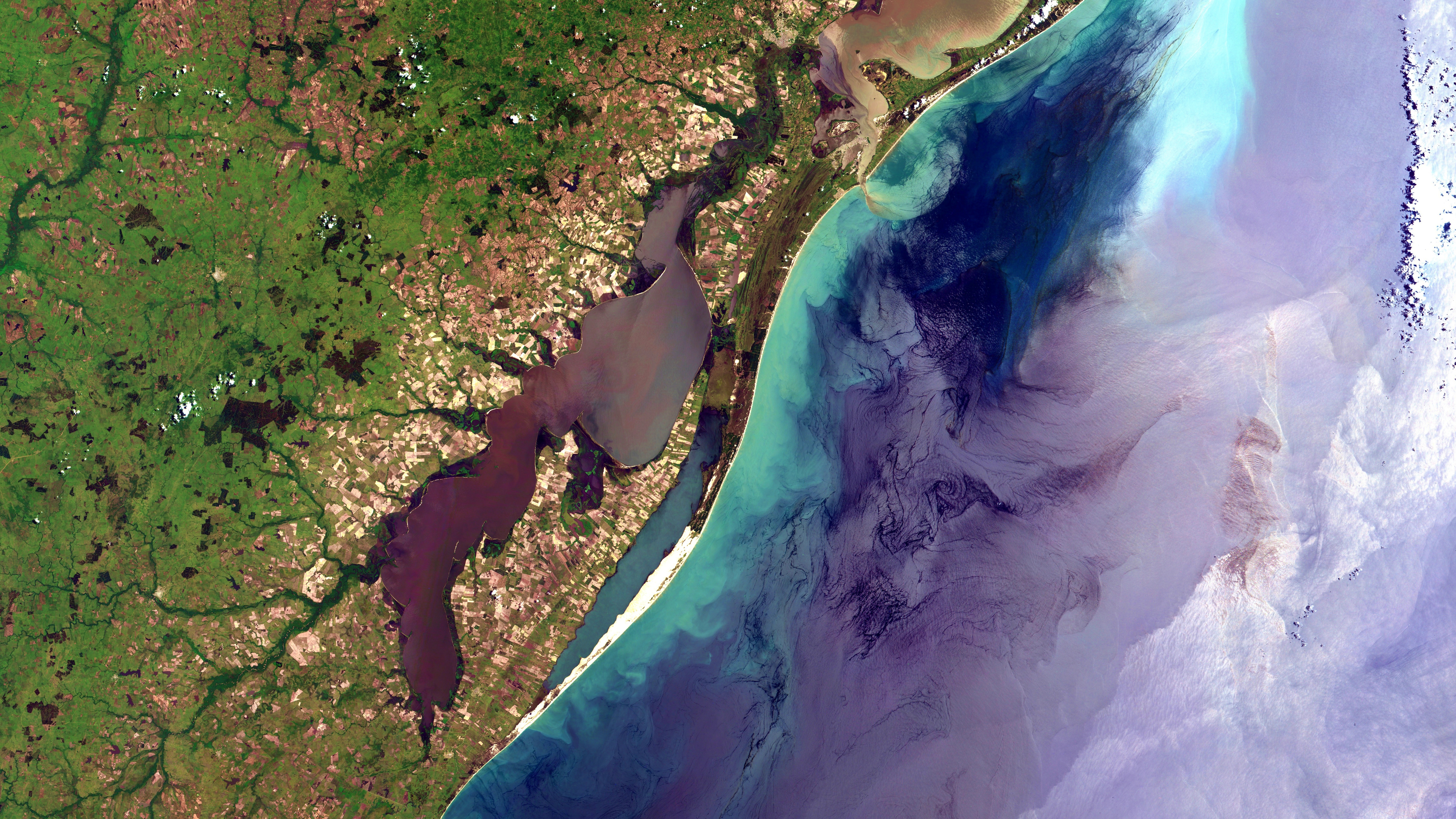
Costa do Rio Grande do Sul de Rio Grande a Santa Vitória do Palmar. Em terra: Padrão quadriculado de amarelo a verde passando por marrom são lotes agrícolas, principalmente arroz irrigado nas terras baixas. Em branco areia das praias. Em marrom e verde, com listras pretas onde alagado, restinga. A Lagoa Mirim está do lado esq. da imagem, em cor cinza arroxeado a esverdeado e preto. No Mar: Áreas próximas a costa com sedimentos e maior atividade biológica em azul claro. Águas profundas em azul escuro ou cinza arroxeado, com sunglint. Na parte de cima da imagem é notável a pluma de sedimentos saindo da Lagoa dos Patos em marrom / Rio Grande do Sul coast from Rio Grande to Santa Vitória do Palmar. At land: Checkred pattern from yellow to brown and green are agriculture plots, mostly lowland irrigated rice. Beaches sand appears in white. In brown and green, with black stripes where flooded, Atlantic coast restingas. Mirim lake is at image left side, in greenish and purpleish grey and black. At sea: In light blue, near the coast, areas with sediments and biological activity. Deep water in dark blue or purpleish gray with sunglint. Notable at image top is Patos lagoon sediments plume, in brown.
#riograndeRS #santavitoriadopalmar #lagoamirim #lagoamangueira #banhadodotaim #santaizabeldosul #riograndedosul #sunglint #taim #arroz #rice #restinga #irrigatedrice #arrozirrigado #sensoriamentoremoto #remotesensing #cbers4 #cbers #inpe #geotecnologias
Imagem / Image CBERS4 AWFI Costa do / Coast of Rio Grande do Sul.
Coordenadas do centro da imagem / Image center: 32°36'36.9"S 52°14'32.3"W
Data / Date: 29-11-2019 / 2019-11-29
RGB151413 (cor verdadeira / true color)
Cena / Scene: 159 / 135
Autor / Author: Oton Barros (DSR/OBT/INPE)
Visite-nos em www.dsr.inpe.br
Comunidade indígena Danta, às margens do Rio Inírida, fluindo de O para L na Bacia do Rio Orinoco na Colômbia. Região 100 km ao N da Cabeça do Cachorro do Brasil, na região do Llanos Colombianos, mosaico savana / floresta. Água do rio em verde bem claro com espuma das corredeiras em branco. No entorno da comunidade, em branco no centro da imagem, manchas verde claro e marrom na floresta são roças de subsistência / Danta indigenous community, by Inírida River, running from W to E on Colombia´s Orinoco Basin. At Colombian llanos region, about 60 mi N of Brazil´s Dog Head, it is on a savanna / forest mosaic. River water appears in very light green with its rapids foam in white. Around the community, wich appears in white at image center, light green and brown spots on the forest are slash-and-burn agriculture.
#colombia #rioinirida #iniridariver #inirida #inírida #forestsavannamosaic #llanos #llanoscolombianos #orinicobasin #comunidadeindigena #indigenouspeople #indígena #indigenous
#sensoriamentoremoto #remotesensing #cbers4 #cbers #inpe #geotecnologias
Imagem / Image CBERS4 MUX Rio Inírida, Amazônia Colombiana / Inírida River, Colombian Amazon
Coordenadas do centro da imagem / Image center: 2°57'52.4"N 68°46'47.3"W
Data / Date: 17-02-2020 / 2020-17-02
RGB 765 (cor verdadeira / true color)
Cena / Scene: 184 / 097
Autor / Author: Oton Barros (DSR/OBT/INPE)
Visite-nos em www.dsr.inpe.br
This is a UK-DMC2 image, acquired on the 4th March 2016.
DMCii supplies satellite imagery products and services to a wide range of international customers from a unique constellation of satellites for agriculture, forestry mapping, disaster monitoring and many more markets. The example above is the Raw Image data from our 22 metre multispectral Satellite, which is split into the 3 spectral bands (NIR, Red and Green) with Radiometric Calibration on all bands.
You can see more data acquired by UK-DMC2 using our catalogue link below.
Join us on our Twitter feed for the latest information,
DMC Constellation, UK-DMC2 image © 2016 Airbus DS
Date: 2022-09-26
Sentinel-2 L2A + Modified SWIR Composite
Author: Monja Šebela
Contains modified Copernicus Sentinel data [2022], processed by Sentinel Hub
Center pivot systems can be an efficient means of meeting the irrigation needs of large, symetrically shaped fields. Photo by John A. Kelley, USDA Natural Resources Conservation Service If this photo is used in a publication, on a web site, or as part of any other project, please use the provided photo credit. This photo may not be used to infer or imply USDA-NRCS endorsement of any product, company, or position. Please do not distort or alter the images the photos portray.
Kaohsiung City, Taiwan after the 6.4 magnitude Earthquake Earthquake struck on the 5th February
DMCii supplies satellite imagery products and services to a wide range of international customers from a unique constellation of satellites for agriculture, forestry mapping, disaster monitoring and many more markets. The example above is the Raw Image data from our 22 metre multispectral Satellite, which is split into the 3 spectral bands (NIR, Red and Green) with Radiometric Calibration on all bands. These are pseudo natural colour images using our UK-DMC2 Satellite.
You can see more about this Disaster from the International Charter, Space & Major Disasters. www.disasterscharter.org/web/guest/-/earthquake-in-taiwan...
You can see more data acquired by UK-DMC2 using our catalogue link below.
Join us on our Twitter feed for the latest information,
DMC Constellation, UK-DMC2 image © 2016
Airbus DS
Haze from the forest fires blanket most parts of the landscape. The rainfall during the flight also contributed to the limited visibility.
Photo by Aulia Erlangga/CIFOR
If you use one of our photos, please credit it accordingly and let us know. You can reach us through our Flickr account or at: cifor-mediainfo@cgiar.org and m.edliadi@cgiar.org
Aerial view of the Amazon Rainforest, near Manaus, the capital of the Brazilian state of Amazonas, Brazil.
Photo by Neil Palmer/CIAT
If you use one of our photos, please credit it accordingly and let us know. You can reach us through our Flickr account or at: cifor-mediainfo@cgiar.org and m.edliadi@cgiar.org
Date: 2020-12-21
Sentinel-2 L2A + Aesthetic Neon Script
Author: Monja Šebela
Contains modified Copernicus Sentinel data [2021], processed by Sentinel Hub
After 38 years, the Mauna Loa, world largest volcano, in the Big Island of Hawaii,has started to erupt again. This is the latest #Sentinel2 image showing the current lava flow , more than 17 km longer heading north, on Dec. 3
Date: 2018-06-10
Sentinel-2 L1C + Modified False Colour Composite
Author: Monja Šebela
Contains modified Copernicus Sentinel data [2018], processed by Sentinel Hub
Aerial view of the Amazon rainforest, near Manaus, the capital of the Brazilian state of Amazonas. Brazil.
Photo by Neil Palmer/CIAT
If you use one of our photos, please credit it accordingly and let us know. You can reach us through our Flickr account or at: cifor-mediainfo@cgiar.org and m.edliadi@cgiar.org
Date: 2018-10-05
Landsat 8 L2 + Custom script
Author: Monja Šebela
Contains modified USGS [2018], processed by Sentinel Hub
The Ellesmerian Orogeny occurred through several tectonic episodes during the Devonian and Carboniferous periods, causing contraction in several terrains of what is now the Arctic Region.
In the Queen Elizabeth Islands, of the North-western Territories of Canada, Ordovician and Devonian rocks were compressed leading to the formation of the Parry Islands Fold Belt, one of the most spectacular frontier regions in petroleum exploration.
Contains Copernicus Sentinel-2 Data. Copyright, CGG NPA SATELLITE MAPPING
Date: 2018-06-13
Sentinel-2 L1C + Modified False Colour Composite
Author: Monja Šebela
Contains modified Copernicus Sentinel data [2018], processed by Sentinel Hub
Time: 2022-07-08
Sentinel-2 L2A + Enhanced Highlight Optimized Natural Color Script
Image Author: Monja Šebela
Contains modified Copernicus Sentinel data [2022], processed by Sentinel Hub
Time: 2022-01-04
Sentinel-2 L2A + modified False Color Composite
Author: Sabina Dolenc
Contains modified Copernicus Sentinel data [2022], processed by Sentinel Hub
This image of crumbled ice along the cost in Saginaw Bay and Sand Point Nature Preserve (right up corner) in Huron County was inspired by kosmi.
Date: 2021-06-26
Sentinel-2 L2A + modified true color script
Author: Monja Šebela
Contains modified Copernicus Sentinel data [2021], processed by Sentinel Hub
A rare prolonged period of clear sky and lack of rains is affecting northern Europe since March 2025. A pleasant consequence is an outstanding rare view of UK and Ireland without clouds captured by Sentinel-3 satellite on April 2.
A new NASA testbed camera called ISERV aboard the International Space Station (ISS) has snapped 24 images of flooded downtown Calgary in Alberta, Canada. On June 22 and the days following, floodwaters ravaged the "Stampede City," forcing the evacuation of over 100,000 residents of Calgary and nearby towns. The ISERV team sent images of the scene to Canadian officials to help with response and assessment.
This image shows Calgary before and after the devastating floods of June 22. The venue for the famous annual rodeo and exhibition known as the Calgary Stampede is annotated in the image.
Read more:
www.nasa.gov/content/nasa-shares-images-from-new-space-st...
Image credit: SERVIR/ISERV
View the ISERV Flickr photoset:
www.flickr.com/photos/nasamarshall/sets/72157633316595189/
_____________________________________________
These official NASA photographs are being made available for publication by news organizations and/or for personal use printing by the subject(s) of the photographs. The photographs may not be used in materials, advertisements, products, or promotions that in any way suggest approval or endorsement by NASA. All Images used must be credited. For information on usage rights please visit: www.nasa.gov/audience/formedia/features/MP_Photo_Guidelin...
Beijing, China
Time: 2020-01-23
Sentinel-2 L2A + Aesthetic Neon Script
Author: Monja Šebela
Contains modified Copernicus Sentinel data [2019], processed by Sentinel Hub
Time: 2022-06-28
Sentinel-2 L2A + Enhanced True Color Composite
Image Author: Monja Šebela
Contains modified Copernicus Sentinel data [2022], processed by Sentinel Hub
A bird's eye view of the stark contrast between the forest and agricultural landscapes near Rio Branco, Acre, Brazil.
Photo by Kate Evans/CIFOR
If you use one of our photos, please credit it accordingly and let us know. You can reach us through our Flickr account or at: cifor-mediainfo@cgiar.org and m.edliadi@cgiar.org
Date: 2021-11-22
Sentinel-2 L2A + Custom Script
Author: Monja Šebela
Contains modified Copernicus Sentinel data [2021], processed by Sentinel Hub
Time: 2022-04-12
Sentinel-2 L2A + False color composite
Image Author: Monja Šebela
Contains modified Copernicus Sentinel data [2022], processed by Sentinel Hub
Date: 2021-08-17
Sentinel-2 L2A + modified Highlight Optimized Natural Color Script
Author: Monja Šebela
Contains modified Copernicus Sentinel data [2022], processed by Sentinel Hub
Date: 2020-08-23
Sentinel-2 L2A + Modified True Color Composite
Author: Monja Šebela
Contains modified Copernicus Sentinel data [2020], processed by Sentinel Hub
An aerial shot shows the contrast between the forest and agricultural landscapes near Rio Branco, Acre, Brazil.
Photo by Kate Evans/CIFOR
If you use one of our photos, please credit it accordingly and let us know. You can reach us through our Flickr account or at: cifor-mediainfo@cgiar.org and m.edliadi@cgiar.org
Reference: APAAME_20221121_RHB-0553
Photographer: Robert Bewley
Credit: APAAME
Copyright: Creative Commons Attribution-Noncommercial-NoDerivative Works
Date: 2018-02-03
Sentinel-2 L1C + True Color Composite
Author: Monja Šebela
Contains modified Copernicus Sentinel data [2018], processed by Sentinel Hub