View allAll Photos Tagged Migrator
The Magellanic Penguin (Spheniscus magellanicus) is a South American penguin, breeding in coastal Argentina, Chile and the Falkland Islands, with some migrating to Brazil where they are occasionally seen as far north as Rio de Janeiro. It is the most numerous of the Spheniscus penguins. Its nearest relatives are the African, the Humboldt and the Galápagos Penguins. The Magellanic penguin was named after Portuguese explorer Ferdinand Magellan, who spotted the birds in 1520. Magellanic Penguins are medium-sized penguins which grow to be 61–76 cm (24–30 in) tall and weigh between 2.7 kg and 6.5 kg (5.9-14.3 lbs).The males are larger than the females, and the weight of both drops while the parents nurture their young.
Adults have black backs and white abdomens. There are two black bands between the head and the breast, with the lower band shaped in an inverted horseshoe. The head is black with a broad white border that runs from behind the eye, around the black ear-coverts and chin, and joins at the throat. Chicks and younger penguins have grey-blue backs, with a more faded grey-blue colour on their chest. Magellanic Penguins can live up to 25 years in the wild, but as much as 30 years in captivity.
Young birds usually have a blotched pattern on their feet, which fades as they grow up into adulthood. By the time these birds reach about ten years of age, their feet usually become all black.
Like other species of penguins, the Magellanic Penguin has very rigid wings used to "fly" or cruise under water.
Kearneys Coaches 00-D-70164,formly of Dublin Bus AV164 swings onto Aston Quay in Dublin.
Reappearing in Dublin after a 4 year stint in the People's Republic,& now with branding since her last appearance on the flickr stream.
June 2017.
Added another 9 images late tonight, all of migrating Snow Geese at Cap Tourmente National Wildlife Area, Quebec. Had hoped to edit more than this today, but didn't have time. They were all taken on 18 May 2018, Day 12 of our holiday in Ontario and Quebec, This was our final day in Quebec, before flying back to Calgary early morning the next day, 19 May 2018.
Sorry, everyone, I must be driving you all crazy! I am posting SO many images, but the end is in sight - yes, thank goodness. Less than a week and I should be done. I honestly don't know how some people go on lots of holidays like this and take thousands of photos and still seem to manage to take a lot shorter time to post them than I have (i.e. nine months). Actually I thought it was even longer than that. I have a deadline for getting all these finished, and it looks like I might meet my deadline after all. Thank you all for your patience!
Day 12 will have photos of some of the 50,000 Snow Geese seen at an amazing Wildlife Area closer to Quebec City. Normally, I rarely see Snow Geese and only far, far away. We also got the chance to photograph a handful of barns, which was much enjoyed.
We stopped at a few places on the long drive between Tadoussac and Quebec City, including Baie-des-Rochers, and Port-au-Persil briefly so that we could take a photos or two of the beautiful old church, Chapelle McLaren, with the St. Lawrence River in the distance. I managed to grab several rapid, drive-by shots of a few barns, which was great. How i would love a holiday just for old barns : )
A really special place we visited closer to Quebec City was the Cap Tourmente National Wildlife Area. Here, we saw an estimated 50,000 Snow Geese, on land, on water, and flying, turning the sky white. This was the first time I have ever been so close to Snow Geese. Some of them waddled within just a few feet of us while we were having a picnic lunch. We went on a walk there and saw some interesting bird species, incluing one tiny Hummingbird.
Trumper Swans migrating on a rainy, windy day today at Creamer's Field. Swans are probably the last migrator to leave the interior of Alaska.
This looks like a family group of two adults and two cygnets.
Polyphemus Moth (Antheraea polyphemus) (male) in flight, having just arrived from over the Atlantic Ocean. Breezy Point, Queens, NY. 07/08/15.
We dayhiked to Keet Seel ( Kawestima). Because of monsoon storms and floods the Ruins and the trail had been closed. We were the second group in after the re-opening. Much of the hike is in the creek. Lots of quicksand but we did a decent job of avoiding most of it.
National Park Service Guide Patrick Joshevama - Hopi (Sun Clan) - took us up to the ruins and brought the history alive with his explanations of how the Hisatsinom lived.
We drove up to Navajo National Monument and camped Friday. Checked in for the Orientation, then hiked around the Rim. On Saturday we dayhiked to Keet Seel - Kawestima. Then went to the Quality Inn in Tuba City. Drove home Sunday. Great trip with good friends.
Here is my triplog of the trip.
hikearizona.com/x.php?I=4&ZTN=186&UID=21152
Where the highway ends, the Ancestral Puebloan Wild West Prehistory Begins...
The prehistoric Puebloan Ancestors built Tsegi Phase villages within the natural sandstone alcoves of our canyons. The resilient Ancestral Puebloans paved the way for current Native American groups in the Southwest region. These villages, which date from AD 1250 to 1300, thrill all who visit with original architectural elements such as roof beams, masonary walls, rock art, and hand and foot holds.
www.desertusa.com/nav/du_nav_desc.html
Centuries ago, the ancestors of the Pueblo Indians lived spread out among the valleys and plateaus of the region, hunting and gathering wild plants and seeds, then migrating elsewhere as the seasons demanded. With the acquisition of domestic seeds for corn and other crops, they gradually became farmers, which allowed them to remain in one place and build permanent shelters, originally pit houses.
As they farmed the plateau and bottomlands of these canyons, they built villages of separate stone houses, and eventually created multi-storied pueblos under the natural shelter of cliff walls and overhangs. But after only a few decades, they disappeared and abandoned these dwellings forever.
Pueblo cultures varied throughout the Southwest. Archeologists use pottery style and decoration, as well as architecture, to divide the cultures of the region into 3 branches: the Chaco, the Mesa Verde and the Kayenta Anasazi. Here among the Kayenta peoples, pottery styles were vivid and multi-colored. Their buildings were more randomly grouped than those elsewhere, and their social organization was less formal.
The Hopi, whose reservation is 50 miles to the south , are believed to be the descendants of the Kayenta Anasazi. The villages preserved at the monument are believed to be paths along the sacred migration route of the 8 Hopi clans. Hopi Tribal elders periodically visit the ruins at the Monument as sacred shrines.
The two largest villages here at the Monument are best known by the names given them by the Navajo, who arrived in the 1800s. Betatakin means "ledge house;" Keet Seel is from an altered Navajo term meaning "remains of square house." The Hopi also have names for these villages, Kawestima and Talastima. While the Navajo referred to the ancient ones as the Anasazi, the Hopi called them the Hisatsinom
Keet Seel
This village was occupied much longer than Betatakin.This alcove was settled as early as 950 by those who built houses and kivas. The village was rebuilt in 1250 by different people and, at its zenith, may have contained 150 residents. By 1300, this village, too, was abandoned.
www4.nau.edu/footprints/07programs.html
"The canyon Tseyi Canyon within which these villages sit are called "Lenaytupqa" or Flute Canyon. It is called that due the presence of the Flute Clan in this area. This canyon feature prominently in Katsina ceremonial traditions today.
Keet Seel is called Kawestima in Hopi. The term is use universally by Hopi to refer to the total area. Kawestima is the ancestral home to the Kookopwungwa (Fire or Burrowing Owl Clan), Tsivatowungwa (Big Horn Sheep Clan) and maybe the Iswungwa (Coyote Clan)."
IMG_0779
Planet Earth Vintage Architecture, PEVA,
The fall migration of Monarch Butterflies came through in mid-September. I had just enough time to get a few shots before they were gone. Sadly, these were the only Monarchs I saw all summer.
The fall migration of Monarch Butterflies came through in mid-September. I had just enough time to get a few shots before they were gone. Sadly, these were the only Monarchs I saw all summer.
Arctic Terns are among the longest migrating birds, they spend out winter in Antarctica and the summer in the far north. I always describe them as afraid of the dark. When you watch them fly it is obvious their efficient flight is what makes the long journey possible.
Whinchats normally found in the North and West of GB (Not my neck of the woods) a small family group stopped off on migration presumably to Africa :0)
For you guys on the coast they are on their way.
Hyderabad (Listeni/ˈhaɪdərəˌbæd/ HY-dər-ə-bad; often /ˈhaɪdrəˌbæd/) is the capital of the southern Indian state of Telangana and de jure capital of Andhra Pradesh. Occupying 625 square kilometres along the banks of the Musi River, it has a population of about 6.8 million and a metropolitan population of about 7.75 million, making it the fourth most populous city and sixth most populous urban agglomeration in India. At an average altitude of 542 metres, much of Hyderabad is situated on hilly terrain around artificial lakes, including Hussain Sagar - predating the city's founding - north of the city centre.
Established in 1591 by Muhammad Quli Qutb Shah, Hyderabad remained under the rule of the Qutb Shahi dynasty for nearly a century before the Mughals captured the region. In 1724, Mughal viceroy Asif Jah I declared his sovereignty and created his own dynasty, known as the Nizams of Hyderabad. The Nizam's dominions became a princely state during the British Raj, and remained so for 150 years, with the city serving as its capital. The city continued as the capital of Hyderabad State after it was brought into the Indian Union in 1948, and became the capital of Andhra Pradesh after the States Reorganisation Act, 1956. Since 1956, Rashtrapati Nilayam in the city has been the winter office of the President of India. In 2014, the newly formed state of Telangana split from Andhra Pradesh and the city became joint capital of the two states, a transitional arrangement scheduled to end by 2025.
Relics of Qutb Shahi and Nizam rule remain visible today, with the Charminar - commissioned by Muhammad Quli Qutb Shah - coming to symbolise Hyderabad. Golconda fort is another major landmark. The influence of Mughlai culture is also evident in the city's distinctive cuisine, which includes Hyderabadi biryani and Hyderabadi haleem. The Qutb Shahis and Nizams established Hyderabad as a cultural hub, attracting men of letters from different parts of the world. Hyderabad emerged as the foremost centre of culture in India with the decline of the Mughal Empire in the mid-19th century, with artists migrating to the city from the rest of the Indian subcontinent. While Hyderabad is losing its cultural pre-eminence, it is today, due to the Telugu film industry, the country's second-largest producer of motion pictures.
Hyderabad was historically known as a pearl and diamond trading centre, and it continues to be known as the City of Pearls. Many of the city's traditional bazaars, including Laad Bazaar, Begum Bazaar and Sultan Bazaar, have remained open for centuries. However, industrialisation throughout the 20th century attracted major Indian manufacturing, research and financial institutions, including Bharat Heavy Electricals Limited, the National Geophysical Research Institute and the Centre for Cellular and Molecular Biology. Special economic zones dedicated to information technology have encouraged companies from across India and around the world to set up operations and the emergence of pharmaceutical and biotechnology industries in the 1990s led to the area's naming as India's "Genome Valley". With an output of US$74 billion, Hyderabad is the fifth-largest contributor to India's overall gross domestic product.
HISTORY
TOPONYMY
According to John Everett-Heath, the author of Oxford Concise Dictionary of World Place Names, Hyderabad means "Haydar's city" or "lion city", from haydar (lion) and ābād (city). It was named to honour the Caliph Ali Ibn Abi Talib, who was also known as Haydar because of his lion-like valour in battles. Andrew Petersen, a scholar of Islamic architecture, says the city was originally called Baghnagar (city of gardens). One popular theory suggests that Muhammad Quli Qutb Shah, the founder of the city, named it "Bhaganagar" or "Bhāgnagar" after Bhagmati, a local nautch (dancing) girl with whom he had fallen in love. She converted to Islam and adopted the title Hyder Mahal. The city was renamed Hyderabad in her honour. According to another source, the city was named after Haidar, the son of Quli Qutb Shah.
EARLY AND MEDIEVAL HISTORY
Archaeologists excavating near the city have unearthed Iron Age sites that may date from 500 BCE. The region comprising modern Hyderabad and its surroundings was known as Golkonda ("shepherd's hill"), and was ruled by the Chalukya dynasty from 624 CE to 1075 CE. Following the dissolution of the Chalukya empire into four parts in the 11th century, Golkonda came under the control of the Kakatiya dynasty from 1158, whose seat of power was at Warangal, 148 km northeast of modern Hyderabad.
The Kakatiya dynasty was reduced to a vassal of the Khilji dynasty in 1310 after its defeat by Sultan Alauddin Khilji of the Delhi Sultanate. This lasted until 1321, when the Kakatiya dynasty was annexed by Malik Kafur, Allaudin Khilji's general. During this period, Alauddin Khilji took the Koh-i-Noor diamond, which is said to have been mined from the Kollur Mines of Golkonda, to Delhi. Muhammad bin Tughluq succeeded to the Delhi sultanate in 1325, bringing Warangal under the rule of the Tughlaq dynasty until 1347 when Ala-ud-Din Bahman Shah, a governor under bin Tughluq, rebelled against Delhi and established the Bahmani Sultanate in the Deccan Plateau, with Gulbarga, 200 km west of Hyderabad, as its capital. The Bahmani kings ruled the region until 1518 and were the first independent Muslim rulers of the Deccan.
Sultan Quli, a governor of Golkonda, revolted against the Bahmani Sultanate and established the Qutb Shahi dynasty in 1518; he rebuilt the mud-fort of Golconda and named the city "Muhammad nagar". The fifth sultan, Muhammad Quli Qutb Shah, established Hyderabad on the banks of the Musi River in 1591, to avoid the water shortages experienced at Golkonda. During his rule, he had the Charminar and Mecca Masjid built in the city. On 21 September 1687, the Golkonda Sultanate came under the rule of the Mughal emperor Aurangzeb after a year-long siege of the Golkonda fort. The annexed area was renamed Deccan Suba (Deccan province) and the capital was moved from Golkonda to Aurangabad, about 550 km northwest of Hyderabad.
MODERN HISTORY
In 1713 Farrukhsiyar, the Mughal emperor, appointed Asif Jah I to be Viceroy of the Deccan, with the title Nizam-ul-Mulk (Administrator of the Realm). In 1724, Asif Jah I defeated Mubariz Khan to establish autonomy over the Deccan Suba, named the region Hyderabad Deccan, and started what came to be known as the Asif Jahi dynasty. Subsequent rulers retained the title Nizam ul-Mulk and were referred to as Asif Jahi Nizams, or Nizams of Hyderabad. The death of Asif Jah I in 1748 resulted in a period of political unrest as his sons, backed by opportunistic neighbouring states and colonial foreign forces, contended for the throne. The accession of Asif Jah II, who reigned from 1762 to 1803, ended the instability. In 1768 he signed the treaty of Masulipatnam, surrendering the coastal region to the East India Company in return for a fixed annual rent.
In 1769 Hyderabad city became the formal capital of the Nizams. In response to regular threats from Hyder Ali (Dalwai of Mysore), Baji Rao I (Peshwa of the Maratha Empire), and Basalath Jung (Asif Jah II's elder brother, who was supported by the Marquis de Bussy-Castelnau), the Nizam signed a subsidiary alliance with the East India Company in 1798, allowing the British Indian Army to occupy Bolarum (modern Secunderabad) to protect the state's borders, for which the Nizams paid an annual maintenance to the British.
Until 1874 there were no modern industries in Hyderabad. With the introduction of railways in the 1880s, four factories were built to the south and east of Hussain Sagar lake, and during the early 20th century, Hyderabad was transformed into a modern city with the establishment of transport services, underground drainage, running water, electricity, telecommunications, universities, industries, and Begumpet Airport. The Nizams ruled their princely state from Hyderabad during the British Raj.
After India gained independence, the Nizam declared his intention to remain independent rather than become part of the Indian Union. The Hyderabad State Congress, with the support of the Indian National Congress and the Communist Party of India, began agitating against Nizam VII in 1948. On 17 September that year, the Indian Army took control of Hyderabad State after an invasion codenamed Operation Polo. With the defeat of his forces, Nizam VII capitulated to the Indian Union by signing an Instrument of Accession, which made him the Rajpramukh (Princely Governor) of the state until 31 October 1956. Between 1946 and 1951, the Communist Party of India fomented the Telangana uprising against the feudal lords of the Telangana region. The Constitution of India, which became effective on 26 January 1950, made Hyderabad State one of the part B states of India, with Hyderabad city continuing to be the capital. In his 1955 report Thoughts on Linguistic States, B. R. Ambedkar, then chairman of the Drafting Committee of the Indian Constitution, proposed designating the city of Hyderabad as the second capital of India because of its amenities and strategic central location. Since 1956, the Rashtrapati Nilayam in Hyderabad has been the second official residence and business office of the President of India; the President stays once a year in winter and conducts official business particularly relating to Southern India.
On 1 November 1956 the states of India were reorganised by language. Hyderabad state was split into three parts, which were merged with neighbouring states to form the modern states of Maharashtra, Karnataka and Andhra Pradesh. The nine Telugu- and Urdu-speaking districts of Hyderabad State in the Telangana region were merged with the Telugu-speaking Andhra State to create Andhra Pradesh,with Hyderabad as its capital. Several protests, known collectively as the Telangana movement, attempted to invalidate the merger and demanded the creation of a new Telangana state. Major actions took place in 1969 and 1972, and a third began in 2010. The city suffered several explosions: one at Dilsukhnagar in 2002 claimed two lives; terrorist bombs in May and August 2007 caused communal tension and riots; and two bombs exploded in February 2013. On 30 July 2013 the United Progressive Alliance (UPA) government of India declared that part of Andhra Pradesh would be split off to form a new Telangana state, and that Hyderabad city would be the capital city and part of Telangana, while the city would also remain the capital of Andhra Pradesh for no more than ten years. On 3 October 2013 the Union Cabinet approved the proposal, and in February 2014 both houses of Parliament passed the Telangana Bill. With the final assent of the President of India in June 2014, Telangana state was formed.
GEOGRAPHY
TOPOGRAPHY
Situated in the southern part of Telangana in southeastern India, Hyderabad is 1,566 kilometres south of Delhi, 699 kilometres southeast of Mumbai, and 570 kilometres north of Bangalore by road. It lies on the banks of the Musi River, in the northern part of the Deccan Plateau. Greater Hyderabad covers 625 km2, making it one of the largest metropolitan areas in India. With an average altitude of 542 metres, Hyderabad lies on predominantly sloping terrain of grey and pink granite, dotted with small hills, the highest being Banjara Hills at 672 metres. The city has numerous lakes referred to as sagar, meaning "sea". Examples include artificial lakes created by dams on the Musi, such as Hussain Sagar (built in 1562 near the city centre), Osman Sagar and Himayat Sagar. As of 1996, the city had 140 lakes and 834 water tanks (ponds).
CLIMATE
Hyderabad has a tropical wet and dry climate (Köppen Aw) bordering on a hot semi-arid climate (Köppen BSh). The annual mean temperature is 26.6 °C; monthly mean temperatures are 21–33 °C. Summers (March–June) are hot and humid, with average highs in the mid-to-high 30s Celsius; maximum temperatures often exceed 40 °C between April and June. The coolest temperatures occur in December and January, when the lowest temperature occasionally dips to 10 °C. May is the hottest month, when daily temperatures range from 26 to 39 °C; December, the coldest, has temperatures varying from 14.5 to 28 °C.
Heavy rain from the south-west summer monsoon falls between June and September, supplying Hyderabad with most of its mean annual rainfall. Since records began in November 1891, the heaviest rainfall recorded in a 24-hour period was 241.5 mm on 24 August 2000. The highest temperature ever recorded was 45.5 °C on 2 June 1966, and the lowest was 6.1 °C on 8 January 1946. The city receives 2,731 hours of sunshine per year; maximum daily sunlight exposure occurs in February.
CONSERVATION
Hyderabad's lakes and the sloping terrain of its low-lying hills provide habitat for an assortment of flora and fauna. The forest region in and around the city encompasses areas of ecological and biological importance, which are preserved in the form of national parks, zoos, mini-zoos and a wildlife sanctuary. Nehru Zoological Park, the city's one large zoo, is the first in India to have a lion and tiger safari park. Hyderabad has three national parks (Mrugavani National Park, Mahavir Harina Vanasthali National Park and Kasu Brahmananda Reddy National Park), and the Manjira Wildlife Sanctuary is about 50 km from the city. Hyderabad's other environmental reserves are: Kotla Vijayabhaskara Reddy Botanical Gardens, Shamirpet Lake, Hussain Sagar, Fox Sagar Lake, Mir Alam Tank and Patancheru Lake, which is home to regional birds and attracts seasonal migratory birds from different parts of the world. Organisations engaged in environmental and wildlife preservation include the Telangana Forest Department, Indian Council of Forestry Research and Education, the International Crops Research Institute for the Semi-Arid Tropics (ICRISAT), the Animal Welfare Board of India, the Blue Cross of Hyderabad and the University of Hyderabad.
ADMINISTRATION
COMMON CAPITAL OF TELANGANA AND ANDHRA PRADESH
According to the Andhra Pradesh Reorganisation Act, 2014 part 2 Section 5: "On and from the appointed day, Hyderabad in the existing State of Andhra Pradesh, shall be the common capital of the State of Telangana and the State of Andhra Pradesh for such period not exceeding ten years. After expiry of the period referred to in sub-section, Hyderabad shall be the capital of the State of Telangana and there shall be a new capital for the State of Andhra Pradesh."
The same sections also define that the common capital includes the existing area designated as the Greater Hyderabad Municipal Corporation under the Hyderabad Municipal Corporation Act, 1955. As stipulated in sections 3 and 18 of the Reorganisation Act, city MLAs are members of Telangana state assembly.
LOCAL GOVERNMENT
The Greater Hyderabad Municipal Corporation (GHMC) oversees the civic infrastructure of the city's 18 "circles", which together encompass 150 municipal wards. Each ward is represented by a corporator, elected by popular vote. The corporators elect the Mayor, who is the titular head of GHMC; executive powers rest with the Municipal Commissioner, appointed by the state government. The GHMC carries out the city's infrastructural work such as building and maintenance of roads and drains, town planning including construction regulation, maintenance of municipal markets and parks, solid waste management, the issuing of birth and death certificates, the issuing of trade licences, collection of property tax, and community welfare services such as mother and child healthcare, and pre-school and non-formal education. The GHMC was formed in April 2007 by merging the Municipal Corporation of Hyderabad (MCH) with 12 municipalities of the Hyderabad, Ranga Reddy and Medak districts covering a total area of 625 km2. In the 2009 municipal election, an alliance of the Indian National Congress and Majlis-e-Ittehadul Muslimeen formed the majority. The Secunderabad Cantonment Board is a civic administration agency overseeing an area of 40.1 km2, where there are several military camps. The Osmania University campus is administered independently by the university authority.
Law and order in Hyderabad city is supervised by the governor of Telangana. The jurisdiction is divided into two police commissionerates: Hyderabad and Cyberabad, which are again divided into four and five police zones respectively. Each zone is headed by a deputy commissioner.
The jurisdictions of the city's administrative agencies are, in ascending order of size: the Hyderabad Police area, Hyderabad district, the GHMC area ("Hyderabad city") and the area under the Hyderabad Metropolitan Development Authority (HMDA). The HMDA is an apolitical urban planning agency that covers the GHMC and its suburbs, extending to 54 mandals in five districts encircling the city. It coordinates the development activities of GHMC and suburban municipalities and manages the administration of bodies such as the Hyderabad Metropolitan Water Supply and Sewerage Board (HMWSSB).
As the seat of the government of Telangana, Hyderabad is home to the state's legislature, secretariat and high court, as well as various local government agencies. The Lower City Civil Court and the Metropolitan Criminal Court are under the jurisdiction of the High Court. The GHMC area contains 24 State Legislative Assembly constituencies, which form five constituencies of the Lok Sabha (the lower house of the Parliament of India).
UTILITY SERVICES
The HMWSSB regulates rainwater harvesting, sewerage services and water supply, which is sourced from several dams located in the suburbs. In 2005, the HMWSSB started operating a 116-kilometre-long water supply pipeline from Nagarjuna Sagar Dam to meet increasing demand. The Telangana Southern Power Distribution Company Limited manages electricity supply. As of October 2014, there were 15 fire stations in the city, operated by the Telangana State Disaster and Fire Response Department. The government-owned India Post has five head post offices and many sub-post offices in Hyderabad, which are complemented by private courier services.
POLLUTION CONTROL
Hyderabad produces around 4,500 tonnes of solid waste daily, which is transported from collection units in Imlibun, Yousufguda and Lower Tank Bund to the dumpsite in Jawaharnagar. Disposal is managed by the Integrated Solid Waste Management project which was started by the GHMC in 2010. Rapid urbanisation and increased economic activity has also led to increased industrial waste, air, noise and water pollution, which is regulated by the Telangana Pollution Control Board (TPCB). The contribution of different sources to air pollution in 2006 was: 20–50% from vehicles, 40–70% from a combination of vehicle discharge and road dust, 10–30% from industrial discharges and 3–10% from the burning of household rubbish. Deaths resulting from atmospheric particulate matter are estimated at 1,700–3,000 each year. Ground water around Hyderabad, which has a hardness of up to 1000 ppm, around three times higher than is desirable, is the main source of drinking water but the increasing population and consequent increase in demand has led to a decline in not only ground water but also river and lake levels. This shortage is further exacerbated by inadequately treated effluent discharged from industrial treatment plants polluting the water sources of the city.
HEALTHCARE
The Commissionerate of Health and Family Welfare is responsible for planning, implementation and monitoring of all facilities related to health and preventive services. As of 2010–11, the city had 50 government hospitals, 300 private and charity hospitals and 194 nursing homes providing around 12,000 hospital beds, fewer than half the required 25,000. For every 10,000 people in the city, there are 17.6 hospital beds, 9 specialist doctors, 14 nurses and 6 physicians. The city also has about 4,000 individual clinics and 500 medical diagnostic centres. Private clinics are preferred by many residents because of the distance to, poor quality of care at and long waiting times in government facilities, despite the high proportion of the city's residents being covered by government health insurance: 24% according to a National Family Health Survey in 2005. As of 2012, many new private hospitals of various sizes were opened or being built. Hyderabad also has outpatient and inpatient facilities that use Unani, homeopathic and Ayurvedic treatments.
In the 2005 National Family Health Survey, it was reported that the city's total fertility rate is 1.8, which is below the replacement rate. Only 61% of children had been provided with all basic vaccines (BCG, measles and full courses of polio and DPT), fewer than in all other surveyed cities except Meerut. The infant mortality rate was 35 per 1,000 live births, and the mortality rate for children under five was 41 per 1,000 live births. The survey also reported that a third of women and a quarter of men are overweight or obese, 49% of children below 5 years are anaemic, and up to 20% of children are underweight, while more than 2% of women and 3% of men suffer from diabetes.
DEMOGRAPHICS
When the GHMC was created in 2007, the area occupied by the municipality increased from 175 km2 to 625 km2. Consequently, the population increased by 87%, from 3,637,483 in the 2001 census to 6,809,970 in the 2011 census, 24% of which are migrants from elsewhere in India, making Hyderabad the nation's fourth most populous city. As of 2011, the population density is 18,480/km2. At the same 2011 census, the Hyderabad Urban Agglomeration had a population of 7,749,334, making it the sixth most populous urban agglomeration in the country. The population of the Hyderabad urban agglomeration has since been estimated by electoral officials to be 9.1 million as of early 2013 but is expected to exceed 10 million by the end of the year. There are 3,500,802 male and 3,309,168 female citizens - a sex ratio of 945 females per 1000 males, higher than the national average of 926 per 1000. Among children aged 0–6 years, 373,794 are boys and 352,022 are girls - a ratio of 942 per 1000. Literacy stands at 82.96% (male 85.96%; female 79.79%), higher than the national average of 74.04%. The socio-economic strata consist of 20% upper class, 50% middle class and 30% working class.
ETHNIC GROUPS, LANGUAGE AND RELIGION
Referred to as "Hyderabadi", residents of Hyderabad are predominantly Telugu and Urdu speaking people, with minority Bengali, Gujarati (including Memon), Kannada (including Nawayathi), Malayalam, Marathi, Marwari, Odia, Punjabi, Tamil and Uttar Pradeshi communities. Hadhrami Arabs, African Arabs, Armenians, Abyssinians, Iranians, Pathans and Turkish people are also present; these communities, of which the Hadhrami are the largest, declined after Hyderabad State became part of the Indian Union, as they lost the patronage of the Nizams.
Telugu is the official language of Hyderabad and Urdu is its second language. The Telugu dialect spoken in Hyderabad is called Telangana, and the Urdu spoken is called Dakhani. English is also used. A significant minority speak other languages, including Hindi, Marathi, Odia, Tamil, Bengali and Kannada.
Hindus are in the majority. Muslims are present throughout the city and predominate in and around the Old City. There are also Christian, Sikh, Jain, Buddhist and Parsi communities and iconic temples, mosques and churches can be seen. According to the 2001 census, Hyderabad district's religious make-up was: Hindus (55.41%), Muslims (41.17%), Christians (2.43%), Jains (0.43%), Sikhs (0.29%) and Buddhists (0.02%); 0.23% did not state any religion.
SLUMS
In the greater metropolitan area, 13% of the population live below the poverty line. According to a 2012 report submitted by GHMC to the World Bank, Hyderabad has 1,476 slums with a total population of 1.7 million, of whom 66% live in 985 slums in the "core" of the city (the part that formed Hyderabad before the April 2007 expansion) and the remaining 34% live in 491 suburban tenements. About 22% of the slum-dwelling households had migrated from different parts of India in the last decade of the 20th century, and 63% claimed to have lived in the slums for more than 10 years. Overall literacy in the slums is 60–80% and female literacy is 52–73%. A third of the slums have basic service connections, and the remainder depend on general public services provided by the government. There are 405 government schools, 267 government aided schools, 175 private schools and 528 community halls in the slum areas. According to a 2008 survey by the Centre for Good Governance, 87.6% of the slum-dwelling households are nuclear families, 18% are very poor, with an income up to ₹20000 (US$300) per annum, 73% live below the poverty line (a standard poverty line recognised by the Andhra Pradesh Government is ₹24000 (US$360) per annum), 27% of the chief wage earners (CWE) are casual labour and 38% of the CWE are illiterate. About 3.72% of the slum children aged 5–14 do not go to school and 3.17% work as child labour, of whom 64% are boys and 36% are girls. The largest employers of child labour are street shops and construction sites. Among the working children, 35% are engaged in hazardous jobs.
NEIGHBOURHOODS
The historic city established by Muhammad Quli Qutb Shah on the southern side of the Musi River forms the "Old City", while the "New City" encompasses the urbanised area on the northern banks. The two are connected by many bridges across the river, the oldest of which is Purana Pul ("old bridge"). Hyderabad is twinned with neighbouring Secunderabad, to which it is connected by Hussain Sagar.
Many historic and tourist sites lie in south central Hyderabad, such as the Charminar, the Mecca Masjid, the Salar Jung Museum, the Nizam's Museum, the Falaknuma Palace, and the traditional retail corridor comprising the Pearl Market, Laad Bazaar and Madina Circle. North of the river are hospitals, colleges, major railway stations and business areas such as Begum Bazaar, Koti, Abids, Sultan Bazaar and Moazzam Jahi Market, along with administrative and recreational establishments such as the Reserve Bank of India, the Telangana Secretariat, the Hyderabad Mint, the Telangana Legislature, the Public Gardens, the Nizam Club, the Ravindra Bharathi, the State Museum, the Birla Temple and the Birla Planetarium.
North of central Hyderabad lie Hussain Sagar, Tank Bund Road, Rani Gunj and the Secunderabad Railway Station. Most of the city's parks and recreational centres, such as Sanjeevaiah Park, Indira Park, Lumbini Park, NTR Gardens, the Buddha statue and Tankbund Park are located here. In the northwest part of the city there are upscale residential and commercial areas such as Banjara Hills, Jubilee Hills, Begumpet, Khairatabad and Miyapur. The northern end contains industrial areas such as Sanathnagar, Moosapet, Balanagar, Patancheru and Chanda Nagar. The northeast end is dotted with residential areas. In the eastern part of the city lie many defence research centres and Ramoji Film City. The "Cyberabad" area in the southwest and west of the city has grown rapidly since the 1990s. It is home to information technology and bio-pharmaceutical companies and to landmarks such as Hyderabad Airport, Osman Sagar, Himayath Sagar and Kasu Brahmananda Reddy National Park.
LANDMARKS
Heritage buildings constructed during the Qutb Shahi and Nizam eras showcase Indo-Islamic architecture influenced by Medieval, Mughal and European styles. After the 1908 flooding of the Musi River, the city was expanded and civic monuments constructed, particularly during the rule of Mir Osman Ali Khan (the VIIth Nizam), whose patronage of architecture led to him being referred to as the maker of modern Hyderabad. In 2012, the government of India declared Hyderabad the first "Best heritage city of India".
Qutb Shahi architecture of the 16th and early 17th centuries followed classical Persian architecture featuring domes and colossal arches. The oldest surviving Qutb Shahi structure in Hyderabad is the ruins of Golconda fort built in the 16th century. The Charminar, Mecca Masjid, Charkaman and Qutb Shahi tombs are other existing structures of this period. Among these the Charminar has become an icon of the city; located in the centre of old Hyderabad, it is a square structure with sides 20 m long and four grand arches each facing a road. At each corner stands a 56 m-high minaret. Most of the historical bazaars that still exist were constructed on the street north of Charminar towards Golconda fort. The Charminar, Qutb Shahi tombs and Golconda fort are considered to be monuments of national importance in India; in 2010 the Indian government proposed that the sites be listed for UNESCO World Heritage status.
Among the oldest surviving examples of Nizam architecture in Hyderabad is the Chowmahalla Palace, which was the seat of royal power. It showcases a diverse array of architectural styles, from the Baroque Harem to its Neoclassical royal court. The other palaces include Falaknuma Palace (inspired by the style of Andrea Palladio), Purani Haveli, King Kothi and Bella Vista Palace all of which were built at the peak of Nizam rule in the 19th century. During Mir Osman Ali Khan's rule, European styles, along with Indo-Islamic, became prominent. These styles are reflected in the Falaknuma Palace and many civic monuments such as the Hyderabad High Court, Osmania Hospital, Osmania University, the State Central Library, City College, the Telangana Legislature, the State Archaeology Museum, Jubilee Hall, and Hyderabad and Kachiguda railway stations. Other landmarks of note are Paigah Palace, Asman Garh Palace, Basheer Bagh Palace, Errum Manzil and the Spanish Mosque, all constructed by the Paigah family.
ECONOMY
Hyderabad is the largest contributor to the gross domestic product (GDP), tax and other revenues, of Telangana, and the sixth largest deposit centre and fourth largest credit centre nationwide, as ranked by the Reserve Bank of India (RBI) in June 2012. Its US$74 billion GDP made it the fifth-largest contributor city to India's overall GDP in 2011–12. Its per capita annual income in 2011 was ₹44300 (US$670). As of 2006, the largest employers in the city were the governments of Andhra Pradesh (113,098 employees) and India (85,155). According to a 2005 survey, 77% of males and 19% of females in the city were employed. The service industry remains dominant in the city, and 90% of the employed workforce is engaged in this sector.
Hyderabad's role in the pearl trade has given it the name "City of Pearls" and up until the 18th century, the city was also the only global trading centre for large diamonds. Industrialisation began under the Nizams in the late 19th century, helped by railway expansion that connected the city with major ports. From the 1950s to the 1970s, Indian enterprises, such as Bharat Heavy Electricals Limited (BHEL), Nuclear Fuel Complex (NFC), National Mineral Development Corporation (NMDC), Bharat Electronics (BEL), Electronics Corporation of India Limited (ECIL), Defence Research and Development Organisation (DRDO), Hindustan Aeronautics Limited (HAL), Centre for Cellular and Molecular Biology (CCMB), Centre for DNA Fingerprinting and Diagnostics (CDFD), State Bank of Hyderabad (SBH) and Andhra Bank (AB) were established in the city. The city is home to Hyderabad Securities formerly known as Hyderabad Stock Exchange (HSE), and houses the regional office of the Securities and Exchange Board of India (SEBI). In 2013, the Bombay Stock Exchange (BSE) facility in Hyderabad was forecasted to provide operations and transactions services to BSE-Mumbai by the end of 2014. The growth of the financial services sector has helped Hyderabad evolve from a traditional manufacturing city to a cosmopolitan industrial service centre. Since the 1990s, the growth of information technology (IT), IT-enabled services (ITES), insurance and financial institutions has expanded the service sector, and these primary economic activities have boosted the ancillary sectors of trade and commerce, transport, storage, communication, real estate and retail.
Hyderabad's commercial markets are divided into four sectors: central business districts, sub-central business centres, neighbourhood business centres and local business centres. Many traditional and historic bazaars are located throughout the city, Laad Bazaar being the prominent among all is popular for selling a variety of traditional and cultural antique wares, along with gems and pearls.
The establishment of Indian Drugs and Pharmaceuticals Limited (IDPL), a public sector undertaking, in 1961 was followed over the decades by many national and global companies opening manufacturing and research facilities in the city. As of 2010, the city manufactured one third of India's bulk drugs and 16% of biotechnology products, contributing to its reputation as "India's pharmaceutical capital" and the "Genome Valley of India". Hyderabad is a global centre of information technology, for which it is known as Cyberabad (Cyber City). As of 2013, it contributed 15% of India's and 98% of Andhra Pradesh's exports in IT and ITES sectors and 22% of NASSCOM's total membership is from the city. The development of HITEC City, a township with extensive technological infrastructure, prompted multinational companies to establish facilities in Hyderabad. The city is home to more than 1300 IT and ITES firms, including global conglomerates such as Microsoft (operating its largest R&D campus outside the US), Google, IBM, Yahoo!, Dell, Facebook, and major Indian firms including Tech Mahindra, Infosys, Tata Consultancy Services (TCS), Polaris and Wipro. In 2009 the World Bank Group ranked the city as the second best Indian city for doing business. The city and its suburbs contain the highest number of special economic zones of any Indian city.
Like the rest of India, Hyderabad has a large informal economy that employs 30% of the labour force. According to a survey published in 2007, it had 40–50,000 street vendors, and their numbers were increasing. Among the street vendors, 84% are male and 16% female, and four fifths are "stationary vendors" operating from a fixed pitch, often with their own stall. Most are financed through personal savings; only 8% borrow from moneylenders. Vendor earnings vary from ₹50 (75¢ US) to ₹800 (US$12) per day. Other unorganised economic sectors include dairy, poultry farming, brick manufacturing, casual labour and domestic help. Those involved in the informal economy constitute a major portion of urban poor.
CULTURE
Hyderabad emerged as the foremost centre of culture in India with the decline of the Mughal Empire. After the fall of Delhi in 1857, the migration of performing artists to the city particularly from the north and west of the Indian sub continent, under the patronage of the Nizam, enriched the cultural milieu. This migration resulted in a mingling of North and South Indian languages, cultures and religions, which has since led to a co-existence of Hindu and Muslim traditions, for which the city has become noted. A further consequence of this north–south mix is that both Telugu and Urdu are official languages of Telangana.[164] The mixing of religions has also resulted in many festivals being celebrated in Hyderabad such as Ganesh Chaturthi, Diwali and Bonalu of Hindu tradition and Eid ul-Fitr and Eid al-Adha by Muslims.
Traditional Hyderabadi garb also reveals a mix of Muslim and South Asian influences with men wearing sherwani and kurta - paijama and women wearing khara dupatta and salwar kameez. Muslim women also commonly wear burqas and hijabs in public. In addition to the traditional Indian and Muslim garments, increasing exposure to western cultures has led to a rise in the wearing of western style clothing among youths.
LITERATURE
In the past, Qutb Shahi rulers and Nizams attracted artists, architects and men of letters from different parts of the world through patronage. The resulting ethnic mix popularised cultural events such as mushairas (poetic symposia). The Qutb Shahi dynasty particularly encouraged the growth of Deccani Urdu literature leading to works such as the Deccani Masnavi and Diwan poetry, which are among the earliest available manuscripts in Urdu. Lazzat Un Nisa, a book compiled in the 15th century at Qutb Shahi courts, contains erotic paintings with diagrams for secret medicines and stimulants in the eastern form of ancient sexual arts. The reign of the Nizams saw many literary reforms and the introduction of Urdu as a language of court, administration and education. In 1824, a collection of Urdu Ghazal poetry, named Gulzar-e-Mahlaqa, authored by Mah Laqa Bai - the first female Urdu poet to produce a Diwan - was published in Hyderabad.
Hyderabad has continued with these traditions in its annual Hyderabad Literary Festival, held since 2010, showcasing the city's literary and cultural creativity. Organisations engaged in the advancement of literature include the Sahitya Akademi, the Urdu Academy, the Telugu Academy, the National Council for Promotion of Urdu Language, the Comparative Literature Association of India, and the Andhra Saraswata Parishad. Literary development is further aided by state institutions such as the State Central Library, the largest public library in the state which was established in 1891, and other major libraries including the Sri Krishna Devaraya Andhra Bhasha Nilayam, the British Library and the Sundarayya Vignana Kendram.
MUSIC AND FILMS
South Indian music and dances such as the Kuchipudi and Kathakali styles are popular in the Deccan region. As a result of their culture policies, North Indian music and dance gained popularity during the rule of the Mughals and Nizams, and it was also during their reign that it became a tradition among the nobility to associate themselves with tawaif (courtesans). These courtesans were revered as the epitome of etiquette and culture, and were appointed to teach singing, poetry and classical dance to many children of the aristocracy. This gave rise to certain styles of court music, dance and poetry. Besides western and Indian popular music genres such as filmi music, the residents of Hyderabad play city-based marfa music, dholak ke geet (household songs based on local Folklore), and qawwali, especially at weddings, festivals and other celebratory events. The state government organises the Golconda Music and Dance Festival, the Taramati Music Festival and the Premavathi Dance Festival to further encourage the development of music.
Although the city is not particularly noted for theatre and drama, the state government promotes theatre with multiple programmes and festivals in such venues as the Ravindra Bharati, Shilpakala Vedika and Lalithakala Thoranam. Although not a purely music oriented event, Numaish, a popular annual exhibition of local and national consumer products, does feature some musical performances. The city is home to the Telugu film industry, popularly known as Tollywood and as of 2012, produces the second largest number of films in India with the largest number being produced by Bollywood. Films in the local Hyderabadi dialect are also produced and have been gaining popularity since 2005. The city has also hosted international film festivals such as the International Children's Film Festival and the Hyderabad International Film Festival. In 2005, Guinness World Records declared Ramoji Film City to be the world's largest film studio.
ART AND HANDICRAFTS
The region is well known for its Golconda and Hyderabad painting styles which are branches of Deccani painting. Developed during the 16th century, the Golconda style is a native style blending foreign techniques and bears some similarity to the Vijayanagara paintings of neighbouring Mysore. A significant use of luminous gold and white colours is generally found in the Golconda style. The Hyderabad style originated in the 17th century under the Nizams. Highly influenced by Mughal painting, this style makes use of bright colours and mostly depicts regional landscape, culture, costumes and jewellery.
Although not a centre for handicrafts itself, the patronage of the arts by the Mughals and Nizams attracted artisans from the region to Hyderabad. Such crafts include: Bidriware, a metalwork handicraft from neighbouring Karnataka, which was popularised during the 18th century and has since been granted a Geographical Indication (GI) tag under the auspices of the WTO act; and Zari and Zardozi, embroidery works on textile that involve making elaborate designs using gold, silver and other metal threads. Another example of a handicraft drawn to Hyderabad is Kalamkari, a hand-painted or block-printed cotton textile that comes from cities in Andhra Pradesh. This craft is distinguished in having both a Hindu style, known as Srikalahasti and entirely done by hand, and an Islamic style, known as Machilipatnam that uses both hand and block techniques. Examples of Hyderabad's arts and crafts are housed in various museums including the Salar Jung Museum (housing "one of the largest one-man-collections in the world"), the AP State Archaeology Museum, the Nizam Museum, the City Museum and the Birla Science Museum.
CUISINE
Hyderabadi cuisine comprises a broad repertoire of rice, wheat and meat dishes and the skilled use of various spices. Hyderabadi biryani and Hyderabadi haleem, with their blend of Mughlai and Arab cuisines, have become iconic dishes of India. Hyderabadi cuisine is highly influenced by Mughlai and to some extent by French, Arabic, Turkish, Iranian and native Telugu and Marathwada cuisines. Other popular native dishes include nihari, chakna, baghara baingan and the desserts qubani ka meetha, double ka meetha and kaddu ki kheer (a sweet porridge made with sweet gourd).
MEDIA
One of Hyderabad's earliest newspapers, The Deccan Times, was established in the 1780s. In modern times, the major Telugu dailies published in Hyderabad are Eenadu, Andhra Jyothy, Sakshi and Namaste Telangana, while the major English papers are The Times of India, The Hindu and The Deccan Chronicle, and the major Urdu papers include The Siasat Daily, The Munsif Daily and Etemaad. Many coffee table magazines, professional magazines and research journals are also regularly published. The Secunderabad Cantonment Board established the first radio station in Hyderabad State around 1919. Deccan Radio was the first radio public broadcast station in the city starting on 3 February 1935, with FM broadcasting beginning in 2000. The available channels in Hyderabad include All India Radio, Radio Mirchi, Radio City, Red FM and Big FM.
Television broadcasting in Hyderabad began in 1974 with the launch of Doordarshan, the Government of India's public service broadcaster, which transmits two free-to-air terrestrial television channels and one satellite channel. Private satellite channels started in July 1992 with the launch of Star TV. Satellite TV channels are accessible via cable subscription, direct-broadcast satellite services or internet-based television. Hyderabad's first dial-up internet access became available in the early 1990s and was limited to software development companies. The first public internet access service began in 1995, with the first private sector internet service provider (ISP) starting operations in 1998. In 2015, high-speed public WiFi was introduced in parts of the city.
EDUCATION
Public and private schools in Hyderabad are governed by the Central Board of Secondary Education and follow a "10+2+3" plan. About two-thirds of pupils attend privately run institutions. Languages of instruction include English, Hindi, Telugu and Urdu. Depending on the institution, students are required to sit the Secondary School Certificate or the Indian Certificate of Secondary Education. After completing secondary education, students enroll in schools or junior colleges with a higher secondary facility. Admission to professional graduation colleges in Hyderabad, many of which are affiliated with either Jawaharlal Nehru Technological University Hyderabad (JNTUH) or Osmania University (OU), is through the Engineering Agricultural and Medical Common Entrance Test (EAM-CET).There are 13 universities in Hyderabad: two private universities, two deemed universities, six state universities and three central universities. The central universities are the University of Hyderabad, Maulana Azad National Urdu University and the English and Foreign Languages University. Osmania University, established in 1918, was the first university in Hyderabad and as of 2012 is India's second most popular institution for international students. The Dr. B. R. Ambedkar Open University, established in 1982, is the first distance learning open university in India.
Hyderabad is also home to a number of centres specialising in particular fields such as biomedical sciences, biotechnology and pharmaceuticals, such as the National Institute of Pharmaceutical Education and Research (NIPER) and National Institute of Nutrition (NIN). Hyderabad has five major medical schools - Osmania Medical College, Gandhi Medical College, Nizam's Institute of Medical Sciences, Deccan College of Medical Sciences and Shadan Institute of Medical Sciences - and many affiliated teaching hospitals. The Government Nizamia Tibbi College is a college of Unani medicine. Hyderabad is also the headquarters of the Indian Heart Association, a non-profit foundation for cardiovascular education.
Institutes in Hyderabad include the National Institute of Rural Development, the Indian School of Business, the Institute of Public Enterprise, the Administrative Staff College of India and the Sardar Vallabhbhai Patel National Police Academy. Technical and engineering schools include the International Institute of Information Technology, Hyderabad (IIITH), Birla Institute of Technology and Science, Pilani – Hyderabad (BITS Hyderabad) and Indian Institute of Technology, Hyderabad (IIT-H) as well as agricultural engineering institutes such as the International Crops Research Institute for the Semi-Arid Tropics (ICRISAT) and the Acharya N. G. Ranga Agricultural University. Hyderabad also has schools of fashion design including Raffles Millennium International, NIFT Hyderabad and Wigan and Leigh College. The National Institute of Design, Hyderabad (NID-H), will offer undergraduate and postgraduate courses from 2015.
SPORTS
The most popular sports played in Hyderabad are cricket and association football. At the professional level, the city has hosted national and international sports events such as the 2002 National Games of India, the 2003 Afro-Asian Games, the 2004 AP Tourism Hyderabad Open women's tennis tournament, the 2007 Military World Games, the 2009 World Badminton Championships and the 2009 IBSF World Snooker Championship. The city hosts a number of venues suitable for professional competition such as the Swarnandhra Pradesh Sports Complex for field hockey, the G. M. C. Balayogi Stadium in Gachibowli for athletics and football, and for cricket, the Lal Bahadur Shastri Stadium and Rajiv Gandhi International Cricket Stadium, home ground of the Hyderabad Cricket Association. Hyderabad has hosted many international cricket matches, including matches in the 1987 and the 1996 ICC Cricket World Cups. The Hyderabad cricket team represents the city in the Ranji Trophy - a first-class cricket tournament among India's states and cities. Hyderabad is also home to the Indian Premier League franchise Sunrisers Hyderabad. A previous franchise was the Deccan Chargers, which won the 2009 Indian Premier League held in South Africa.
During British rule, Secunderabad became a well-known sporting centre and many race courses, parade grounds and polo fields were built. Many elite clubs formed by the Nizams and the British such as the Secunderabad Club, the Nizam Club and the Hyderabad Race Club, which is known for its horse racing especially the annual Deccan derby, still exist. In more recent times, motorsports has become popular with the Andhra Pradesh Motor Sports Club organising popular events such as the Deccan 1/4 Mile Drag, TSD Rallies and 4x4 off-road rallying.
International-level sportspeople from Hyderabad include: cricketers Ghulam Ahmed, M. L. Jaisimha, Mohammed Azharuddin, V. V. S. Laxman, Venkatapathy Raju, Shivlal Yadav, Arshad Ayub and Noel David; football players Syed Abdul Rahim, Syed Nayeemuddin and Shabbir Ali; tennis player Sania Mirza; badminton players S. M. Arif, Pullela Gopichand, Saina Nehwal, P. V. Sindhu, Jwala Gutta and Chetan Anand; hockey players Syed Mohammad Hadi and Mukesh Kumar; rifle shooters Gagan Narang and Asher Noria and bodybuilder Mir Mohtesham Ali Khan.
TRANSPORT
The most commonly used forms of medium distance transport in Hyderabad include government owned services such as light railways and buses, as well as privately operated taxis and auto rickshaws. Bus services operate from the Mahatma Gandhi Bus Station in the city centre and carry over 130 million passengers daily across the entire network. Hyderabad's light rail transportation system, the Multi-Modal Transport System (MMTS), is a three line suburban rail service used by over 160,000 passengers daily. Complementing these government services are minibus routes operated by Setwin (Society for Employment Promotion & Training in Twin Cities). Intercity rail services also operate from Hyderabad; the main, and largest, station is Secunderabad Railway Station, which serves as Indian Railways' South Central Railway zone headquarters and a hub for both buses and MMTS light rail services connecting Secunderabad and Hyderabad. Other major railway stations in Hyderabad are Hyderabad Deccan Station, Kachiguda Railway Station, Begumpet Railway Station, Malkajgiri Railway Station and Lingampally Railway Station. The Hyderabad Metro, a new rapid transit system, is to be added to the existing public transport infrastructure and is scheduled to operate three lines by 2015. As of 2012, there are over 3.5 million vehicles operating in the city, of which 74% are two-wheelers, 15% cars and 3% three-wheelers. The remaining 8% include buses, goods vehicles and taxis. The large number of vehicles coupled with relatively low road coverage - roads occupy only 9.5% of the total city area - has led to widespread traffic congestion especially since 80% of passengers and 60% of freight are transported by road. The Inner Ring Road, the Outer Ring Road, the Hyderabad Elevated Expressway, the longest flyover in India, and various interchanges, overpasses and underpasses were built to ease the congestion. Maximum speed limits within the city are 50 km/h for two-wheelers and cars, 35 km/h for auto rickshaws and 40 km/h for light commercial vehicles and buses.
Hyderabad sits at the junction of three National Highways linking it to six other states: NH-7 runs 2,369 km from Varanasi, Uttar Pradesh, in the north to Kanyakumari, Tamil Nadu, in the south; NH-9, runs 841 km east-west between Machilipatnam, Andhra Pradesh, and Pune, Maharashtra; and the 280 km NH-163 links Hyderabad to Bhopalpatnam, Chhattisgarh. Five state highways, SH-1, SH-2, SH-4, SH-5 and SH-6, either start from, or pass through, Hyderabad.
Air traffic was previously handled via Begumpet Airport, but this was replaced by Rajiv Gandhi International Airport (RGIA) (IATA: HYD, ICAO: VOHS) in 2008, with the capacity of handling 12 million passengers and 100,000 tonnes of cargo per annum. In 2011, Airports Council International, an autonomous body representing the world's airports, judged RGIA the world's best airport in the 5–15 million passenger category and the world's fifth best airport for service quality.
WIKIPEDIA
A migrating Monarch in the yard. Just a few years ago I could see groups of migrating Monarchs flying over the red dirt hill behind the house. Today I only see one here and there. I hope it isn't too late to save this beautiful species.
Brick Lane (Bengali: ব্রিক লেন) is a street in the East End of London, in the Borough of Tower Hamlets. It runs from Swanfield Street in Bethnal Green, crosses Bethnal Green Road in Shoreditch, enters Whitechapel and is linked to Whitechapel High Street to the south by the short stretch of Osborn Street. Today, it is the heart of the city's Bangladeshi community and is known to some as Banglatown. It is famous for its many curry houses.
Winding through fields, the street was formerly called Whitechapel Lane. It derives its current name from brick and tile manufacture started in the 15th century, which used the local brick earth deposits. and featured in the 16th century Woodcut map of London as a partially-developed crossroad leading north from the city's most easterly edge. By the 17th century, the street was being developed northwards from the Barres (now Whitechapel High Street) as a result of expanding population.
Brewing came to Brick Lane before 1680, with water drawn from deep wells. One brewer was Joseph Truman, first recorded in 1683. His family, particularly Benjamin Truman, went on to establish the sizeable Black Eagle Brewery on Brick Lane. The Brick Lane Market first developed in the 17th century for fruit and vegetables sold outside the City.
Successive waves of immigrants settled in the area: in the 17th century, French Huguenots expanded into the area for housing; the master weavers were based in Spitalfields. Starting with the Huguenots, the area became a centre for weaving, tailoring and the developing clothing industry. It continued to attract immigrants, who provided semi- and unskilled labour.
In the 19th century, Irish people and Ashkenazi Jews immigrated to the area. Jewish immigration continued into the early 20th century.
The Sunday market, like the ones on Petticoat Lane and nearby Columbia Road, dates from a dispensation given by the government to the Jewish community in the 19th century. At the time, there were no Sunday markets open because of the Christian observance of Sabbath. Located at the junction of Cheshire and Sclater streets, the market sells bric-a-brac as well as fruit, vegetables and many other items. In 2015 it was identified by police as the focal point of a trade in stolen bicycles and bicycle parts, many taken from City of London employees who had used "cycle to work" schemes. Alongside seven arrests, the police also warned purchasers that buying bicycles or parts in deals "too good to be true" could make them guilty of handling stolen goods. Near the junction with Hanbury Street are two indoor markets; Upmarket and Backyard Market. In 2010, the Brick Lane Farmers' Market opened, intended to be held every Sunday in nearby Bacon Street; it has now closed.
In the later 20th century, Bangladeshis comprised the major group of immigrants and gradually predominated in the area. Many Bangladeshi immigrants to Brick Lane were from the Greater Sylhet region. These settlers helped shape Bangladeshi migration to Britain; many families from Jagannathpur and Bishwanath tend to live in the Brick Lane area.
In 1742, La Neuve Eglise, a Huguenot chapel, was built on the corner of Brick Lane and Fournier Street. By 1809, it was used by missionaries as The Jews’ Chapel, where they promoted Christianity to the expanding Jewish population. It was adapted as a Methodist Chapel in 1819 for Protestant residents. (John Wesley had preached his first "covenant sermon" at the nearby Black Eagle Street Chapel).
Reflecting the changing demographics of the area, in 1898, the building was consecrated as the Machzikei HaDath, or Spitalfields Great Synagogue. After decades of change in the area, with Jews moving out and Bangladeshis moving in, in 1976 it was adapted again as the London Jamme Masjid (Great London Mosque) to serve the expanding Bangladeshi community. The building is Grade II* listed.
In the 20th century the Brick Lane area was important in the second wave of development of Anglo-Indian cuisine, as families from countries such as Bangladesh (mainly the Greater Sylhet region) migrated to London to look for work. Some curry houses of Brick Lane do not sell alcohol as most are owned by Muslims.
Bengalis in the United Kingdom settled in big cities with industrial employment. In London, many Bengali people settled in the East End. For centuries the East End has been the first port of call for many immigrants working in the docks and shipping from Chittagong port in Bengal (British Empire in India was founded and based in Bengal). Their regular stopover paved the way for food/curry outlets to be opened up catering for an all-male workforce as family migration and settlement took place some decades later. Humble beginnings such as this gave birth to Brick Lane as the famous curry capital of the UK. Bengalis of Sylheti origin constitute only 10% of all South Asians in Britain; however around 90% of all South Asian restaurants in the UK are Sylheti- or Bengali-owned.
More recently the area has also broadened to being a vibrant art and fashion student area, with considerable exhibition space. Each year most of the fine art and fashion courses exhibit their work near Brick Lane.
Since the late 1990s, Brick Lane has been the site of several of the city's best known night clubs, notably 93 Feet East and The Vibe Bar, both built on the site of The Old Truman Brewery, once the industrial centre of the area, and now an office and entertainment complex. In 1999, it was the scene of a bombing that injured 13 people.
Brick Lane has a regular display of graffiti, which features artists such as Banksy, Stik, ROA, D*Face, Ben Eine and Omar Hassan. The lane has been used in many music videos such as "Glory Days" by Just Jack, "All These Things That I've Done" by The Killers and "Überlin" by R.E.M..
(Wikipedia)
Die Brick Lane (Bengali: ব্রিক লেন) ist eine Straße im Londoner Stadtbezirk Tower Hamlets. Sie führt von Bethnal Green im Norden durch Spitalfields bis Whitechapel im Süden und ist eine der bekanntesten Straßen des Londoner East Ends. Die Straße gilt als das Herz der Bangladeschi-Gemeinde Londons und ist unter anderem für ihre zahlreichen südasiatischen Restaurants und ihren Straßenmarkt bekannt. Straße und Straßenmarkt gelten heute als Londoner Touristenattraktion.
Die Brick Lane ist rund einen Kilometer lang und größtenteils nur in eine Richtung befahrbar.
Ursprünglich trug die Straße den Namen Whitechapel Lane und verlief in einer ländlichen Gegend. Ihr heutiger Name bezieht sich auf die Backstein-Produktion, die seit dem 15. Jahrhundert den lokalen Ziegellehm verarbeitete. Im 17. Jahrhundert entwickelte sich die Straße aufgrund des Bevölkerungszuwachses zu einem Wohngebiet. Zahlreiche Einwanderer ließen sich in der Gegend nieder, so zunächst französische Hugenotten. In dieser Zeit entwickelte sich der Stadtteil zu einem Zentrum des Weberhandwerks, der Schneiderei und Bekleidungsherstellung.
Im 19. Jahrhundert ließen sich zunehmend irische Immigranten und aschkenasische Juden in der Brick Lane nieder. Zu Beginn des 20. Jahrhunderts erhöhte sich die Zahl der Juden durch eine neue Einwanderungswelle. Im späten 20. Jahrhundert kam eine neue Gruppe von Einwanderern aus Bangladesch hinzu, die die Straße inzwischen dominiert und prägt.
1742 erbauten die Hugenotten La Neuve Eglise, eine protestantische Kirche, an der Ecke Brick Lane und Fournier Street. Ab 1809 wurde sie von Missionaren als The Jews’ Chapel zur Missionierung der wachsenden jüdischen Bevölkerung genutzt. Von 1819 an diente sie der methodistischen Gemeinde als Kirche, ab 1898 war sie unter dem Namen Machzikei HaDath Synagoge. Nach dem Zuzug zahlreicher Bangladesher dient sie seit 1976 unter dem Namen London Jamme Masjid als Moschee. Das Gebäude steht unter Denkmalschutz (Grade II* listed).
(Wikipedia)
About 500,000 migrating snow geese at Loess Bluffs National Wildlife Refuge. They are incredibly loud, and move as a group that, at times, looks like a dark cloud in the sky.
This year the cranes are flying in small groups over many days. Some years, thousands may be seen in one day circling around yodeling away.
like a backwards bird, I came back north at the end of the summer... the second run at Umeå begins soon and I am enjoying what's left of the northern summer.
Taken at Lowtide at Gatakers bay, Pt vernon, Hervey bay, Queensland, Australia.
Panorama stitched together using photoshop elements 11.
Hervey/ˈhɑrvi ˈbeɪ/ is a city in Queensland, Australia. The city is situated approximately 290 kilometres (180 mi) or 3½ hours highway drive north of the state capital, Brisbane. It is a natural bay between the Queensland mainland and nearby Fraser Island. The local economy relies on tourism which is based primarily around whale watching in Platypus Bay to the North, access to Fraser Island, accessible recreational fishing and boating and the natural north facing, calm beaches with wide undeveloped foreshore zones.
At the 2011 Australian Census the city recorded a population of 76,403.[1] Hervey Bay is an area of high population growth...
Climate
Hervey Bay has a mild climate with an average 30 °C (86 °F) in summer and 22 °C (72 °F) in winter. The coast is predominantly affected by the south east trade winds throughout the summer with occasional strong northerly winds and storm swells. These winds keep the temperatures down in summer and up in winter, preventing temperature extremes. As a result, Hervey Bay rarely experiences temperatures over 35 °C (95 °F) in summer or under 5 °C (41 °F) in winter.
Cyclones are a threat at times with Cyclone Hamish threatening in 2009 as a Category 5. The land mass of Fraser Island significantly affects the pattern of weather in Hervey Bay and protects the immediate marine environment from open ocean storm effects. Cyclone Oswald in 2013 caused significant damage in the area, mainly as a result of tornadoes spawned by the system. The average rainfall for the year is around 1,100 millimetres (43 in). December to March is the main rainy period, with a secondary peak in May and June. The months of April and from July to November are generally dry and sunny.
Whale watching
Hervey Bay is the whale watching capital of Australia, with humpback whales migrating along the coast between April and October every year. Researchers at the Oceania Project conducted a 14 year study which found the bay was an important social hub for humpback whales.[15] Whale number have increased from about 2,000 in 1992, to around 7,000 in 2005.[15] Hervey Bay is the resting place for Humpback whales, Mum's and Calves, they come to the Bay to rest and build up energy for their long travels back to Antarctica. The Adults come to play, socialise and there have been heat runs observed in the Bay. The Humpback Whales are known to be very relaxed in the company of the whale watching vessels.
Scots Illustrator Angus McBride:
~~~~~~~~~~~~~~~~~~~~~~~~~~~~~~~~~~~~~~~~~~~~~~~~~~
www.theguardian.com/news/2007/may/26/guardianobituaries.a...
~~~~~~~~~~~~~~~~~~~~~~~~~~~~~~~~~~~~~~~~~~~~~~~~~~
Brennus or Brennos (Gaulish: Brano "raven") is the name of two Gaulish chieftains, famous in ancient history:
Brennus, chieftain of the Senones, a Gallic tribe originating from the modern areas of France known as Seine-et-Marne, Loiret, and Yonne; in 387 BC, in the Battle of the Allia, he led an army of Cisalpine Gauls in their attack on Rome.
This one . Another Brennus was one of the leaders of the army of Gauls who attempted to invade and settle in the Greek mainland in 278 BC. After a looting spree and after managing to pass Thermopylae by encircling the Greek army and forcing it to retreat he made his way to the rich treasury at Delphi but he was defeated by the re-assembled Greek army. Brennus was heavily injured at the battle of Delphi and may have committed suicide there. This Brennus invaded Greece in 281 BC with a huge war band and was turned back before he could plunder the temple of Apollo at Delphi. At the same time, another Gaulish group of men, women, and children were migrating through Thrace. They had split off from Brennus' people in 279 BC, and had migrated into Thrace under their leaders Leonnorius and Lutarius. These invaders appeared in Asia Minor in 278–277 BC.
John T. Koch, "Brân, Brennos: an instance of Early Gallo-Brittonic history and mythology'", Cambridge Medieval Celtic Studies 20 (Winter 1990:1-20).
______________________________________________
The Athenian Treasury at Delphi would have been one of the more wealthy there for the ancient pilgrims.
www.flickr.com/photos/celtico/23240585430/
Delphi was founded in the 'navel' of the known world by the Greek father god Zeus , he released two eagles that circumnavigated the world, where the two eagles met became the place to talk to their gods via the oracles or pythos. Apollo had a temple here. Before this, the major ancient site, a place of pilgrimage for Greeks
had been the Gates of Hades or the Underworld.
These Gauls (later some became Galatians) reached Delphi, to attack the Temple of Apollo in mid winter.An inscription near the oracle perhaps from older times was 'Know Thyself'.Delphi became the site of a major temple to Phoebus Apollo, as well as the Pythian Games and the famous prehistoric oracle. Even in Roman times, hundreds of votive statues remained, described by Pliny the Younger and seen by Pausanias.
www.livius.org/sources/content/pausanias-guide-to-greece/...
Carved into the temple were three phrases: γνῶθι σεαυτόν (gnōthi seautón = "know thyself") and μηδέν άγαν (mēdén ágan = "nothing in excess"), and Ἑγγύα πάρα δ'ἄτη (eggýa pára d'atē = "make a pledge and mischief is nigh"), In ancient times, the origin of these phrases was attributed to one or more of the Seven Sages of Greece.
Additionally, according to Plutarch's essay on the meaning of the "E at Delphi"—the only literary source for the inscription—there was also inscribed at the temple a large letter E.Among other things epsilon signifies the number 5.
According to one pair of modern scholars, "The actual authorship of the three maxims set up on the Delphian temple may be left uncertain. Most likely they were popular proverbs, which tended later to be attributed to particular sages."
A great actual and mythic battle began, recorded well after Greece was under Rome's dominion.
The Greeks had asked the gods for help to protect their sacred temple and treasury which was a focal point of their lives. Accordingly ,the pleas were 'answered' and there were earthquakes and thunderbolts and even rock slides from nearby Mount Parnassus upon the enemy. Still the Celts or Gauls fought on , a famous earlier story to Alexander the Great when he went north of the Danube briefly and met chieftains of the Gauls or Celts , who implied they were only fearful of the sky falling in....so he might have considered them too reckless rather than brave ...he may have thought they might fear him?
24.media.tumblr.com/tumblr_mcbsidHvJH1qaxacfo1_500.jpg
The Greeks again asked for divine help. During the night, the Celts were said to 'panic' and fight each other. Pausanias, writing over 300 years later in Roman times ,described the mayhem as "causeless terrors are said to come from the god Pan". Eventually the Celts retreated after suffering grievous losses, 26,000 dead, according to the Greek historian Pausanias in later times. Here is Pausanias describing the battle which was fought with symbolic divine aid (or knowledge of a primal fear of the Celts) as mentioned earlier to Alexander the Great of Macedonia :
Pausanias (geographer), Greek traveller, geographer, and writer (Description of Greece) of the 2nd century AD. As a Greek writing under the auspices of the Roman empire, he found himself in an awkward cultural space, between the glories of the Greek past he was so keen to describe and the realities of a Greece beholden to Rome as a dominating imperial force. His work bears the marks of his attempt to navigate that space and establish an identity for Roman Greece.
en.wikipedia.org/wiki/Pausanias_(geographer)
Pausanias has the instincts of an antiquary.
en.wikipedia.org/wiki/Pausanias_%28geographer%29
Ptolemy Keraunos (Greek: Πτολεμαῖος Κεραυνός, died 279 BC) was the arrogant ,murderous King of Macedon from 281 BC to 279 BC. His epithet Keraunos is Greek for "Thunder" or "Thunderbolt". See more on him here:
However, although Keraunos was at the zenith of his power, he did not live long afterwards. In 279 BC he was captured and killed (beheaded) during the wars against the Gauls led by Bolgios ("Lightening" ) who conducted a series of mass raids against Macedon and the rest of Greece.His death brought anarchy to the Greek states, since none of his successors were able to bring stability. This situation lasted about two years, until Antigonos Gonatas defeated the Gauls in the battle near Lysimachia, Thrace, in 277 BC, After this victory he was recognized king of Macedon and his power extended eventually also to south Greece.
en.wikipedia.org/wiki/File:Antigonus_Gonatas_British_Muse...
en.wikipedia.org/wiki/File:AntigonusGonatas.jpg
The Antigonid dynasty was a dynasty of Hellenistic kings descended from Alexander the Great's general Antigonus I Monophthalmus ("the One-eyed"). It was one of four dynasties established by Alexander's successors, the others being the Seleucid dynasty, Ptolemaic dynasty and Attalid dynasty. The last scion of the dynasty, Perseus of Macedon, who reigned between 179-168 BCE, proved unable to stop the advancing Roman legions and Macedon's defeat at the Battle of Pydna signaled the end of the dynasty.
skyelander.orgfree.com/celts4.html
Spanish language source internet illustration on ancient tribal attire.
www.housebarra.com/EP/ep04/15celtclothes.html
Several versions out there, if copyrighted please let me know.
Source is likely to be.... from an interesting book called 'Rome's Enemies 2 Gallic and British Celts', #158 in the Ospreys , Men-At-Arms Series, by Peter Wilcox and Angus MacBride (ISBN: 0850456061), 1985. The paintings, done by McBride, (see his picture here)
www.flickr.com/photos/roondorozhand/3234794396/
are based on literary descriptions and archeological finds and are said to be as accurate as possible at this time. www.flickr.com/photos/ancientgreekmapsandmore/2133688042/
www.youtube.com/watch?v=BZPd2DS5sq4
(NO , Not a~vik~ing, they who came from the north, hundreds of years later).See theTaking of the Temple at Delphi by the Gauls, 1885 by Alphonse Cornet a French Academic Classical artist born 1814 - died 1874.
The earliest directly attested examples of a Celtic language are the Lepontic .Lepontic is an extinct Alpine language that was spoken in parts of Rhaetia and Cisalpine Gaul between 550 and 100 BC. It is generally regarded as a Celtic language, although its exact classification within Celtic, or even within the western Indo-European languages, has been the object of debate...
inscriptions, beginning from the 6th century BC.The Continental Celtic languages were spoken by the people known to Roman and Greek writers as Keltoi,...
are attested only in inscriptions and place-names. Insular Celtic is attested from about the 4th century AD in ogham inscriptions, although it is clearly much earlier. Literary tradition begins with Old Irish from about the 8th century. Coherent texts of Early Irish literature. Early Irish literature-The earliest Irish authors:It is unclear when literacy first came to Ireland. The earliest Irish writings are inscriptions, mostly simple memorials, on stone in the ogham alphabet, the earliest of which date to the fourth century..., such as the Táin Bó Cúailnge (a legendary tale from early Irish literature, often considered an epic, although it is written primarily in prose rather than verse)...(The Cattle Raid of Cooley), survive in 12th-century recensions. According to the theory of Professor John T. Koch is an American academic, historian and linguist who specializes in Celtic studies, especially prehistory and the early Middle Ages....
and others.The Tartessian language, also known as Southwestern or South Lusitanian, is a Paleohispanic language once spoken in the southwest of the Iberian Peninsula: mainly in the south of Portugal , but also in Spain...may have been the earliest directly attested Celtic language with the Tartessian written script used in the inscriptions based on a version of a Phoenician script in use around 825 BC.
GREEK RELIEF writing on tablet 3RD BCE
Decree of the town of Cos, Greece. Inscription on stone about the conquest of Delphi by the Gauls under Brennus in March 278 BCE, followed by news of the expulsion of the Gauls from Delphi in the Archaeological Museum, Istanbul, modern Turkey.
www.lessing-photo.com/dispimg.asp?i=10010366+&cr=1679...
Synonyms: Bryth, Gaul: The Raven King
A Brennos , Brennos of the Senones, first appears as the Celtic or Gaulish hero who led the Celtic sack of Rome. During the third century BCE the Celtic expansion led them to the Po valley in Italy. Fearful of this expansion the Etruscans called , on their adversaries, Rome for assistance. The Romans sent three envoys to meet the Celtic leaders. However, one of the Roman envoys killed a Celtic chief and Rome sent an army of 40 000 to meet these 'barbarians'. When the Celts learned of the Roman army moving towards them, Brennos (most likely a chiefly title rather than a real name, like a Duke, see below) marched the Celts off to meet the Romans. The Celts met the Romans at the River Allia, the Romans panicked at the sight of all those crazed Celts, and many Roman soldiers even drowned in the River in attempt to escape. A few made it back to Rome and informed the Senate about the battle at Allia (the date of the battle, July 18, became known as Alliaensis, and was considered thereafter to be a very bad day to do any public activity). The Roman citizens, rightfully fearing that the Celts were headed toward Rome, fled in a panic (much like the soldiers at Allia). By the time the Celts/ Gauls arrived, Rome had been deserted, with the exception of several elderly patricians. These old patricians were sitting in a courtyard, believing that if they were to sacrifice their lives for Rome in its most dire hour of need, Rome's enemies would then be thrown into panic and confusion, and Rome thereby saved. This nearly worked, but the spell of quietude was broken and Rome was looted and the old men killed. They advanced on the Capitol, but were thwarted by plague and a night-time attack was spoiled by cackling of geese. However, about seven months, later the Romans decided to negotiate and the Celts agreed to leave if the Romans would pay them 1,000 pounds of gold. The Celts were accused of using false weights, upon which Brennos (the Celtic chieftain) is said to have thrown his sword on the scales and loudly declare, "Vea victus", or "woe to the defeated".
www.flickr.com/photos/96490373@N02/14550761807/
cgi.ebay.com/Ancient-Roman-Dictator-Brennus-c1915-Card-/3...
www.flickr.com/photos/summoning_ifrit/4211154813/
The early 4th century BCE a vast group of Gauls sacked the city of Rome. Romans gave it up rather easily, actually. Most fled to neighbouring cities like Veii while the Senate, priests, and what was left of the Roman army migrated to the Capitol - defending and taking refuge in the temples there. The Gauls made easy pickings of what they found in the city. According to Livy:
For several days they had been directing their fury only against bricks and mortar. Rome was a heap of smouldering ruins, but something remained - the armed men in the Citadel, and when the Gauls saw that, in spite of everything, they remained unshaken and would never yield to anything but force, they resolved to attempt an assault. At dawn, therefore, on a given signal the whole vast horde assembled in the Forum; then, roaring out their challenge, they locked shields and moved up the slope of the Capitol." (5.43)
The Romans, however, used the advantage of being at the top of the hill and managed to beat the Gauls back. Yet the Gauls were determined and even though they had destroyed most of the food and supplies in their initial sack of the city, they began a siege on the hill.
During all of this, officials in Veii were determined to get a message through to the Roman Senate - despite the fact that the Senate was under siege. As the old saying goes, 'if there's a will, there's a way', and a young Roman soldier named Pontius Cominus managed to do it. "Floating on a life-buoy down the river to Rome, he took the shortest way to the Capitol up and over a bluff so steep that the Gauls had never thought of watching it." (5.46) But the Gauls did find out about it and figured if he could do it, then they should all be able to do it too.
One starlit night, they made the attempt. Having first sent an unarmed man to reconnoitre the route, they began the climb. It was something of a scramble: at the awkward spots a man would get a purchase for his feet on a comrade below him, then haul him up in his turn - weapons were passed up from hand to hand as the lie of the rocks allowed - until by pushing and pulling on another they reached the top. What is more, they accomplished the climb so quietly that the Romans on guard never heard a sound, and even the dogs - who are normally aroused by the least noise in the night - noticed nothing. It was the geese that saved them - Juno's sacred geese, which in spite of the dearth of provisions had not been killed. The cackling of the birds and the clapping of their wings awoke Marcus Manlius - a distinguished officer who had been consul three years before - and he, seizing his sword and giving the alarm, hurried, without waiting for the support of his bewildered comrades, straight to the point of danger. (5.46)
And that is either Roman spin or real history of how the sacred geese of Juno saved Rome - since after that last attempt, the lack of food forced the Gaul to accept payment from the Romans to leave the city alone.
www.mmdtkw.org/AU0308bJunoMonetaGeese.jpg
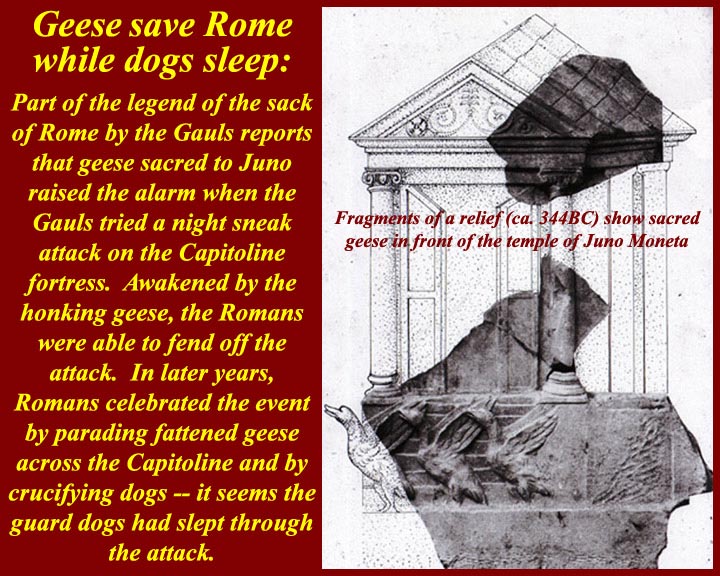
www.mmdtkw.org/AU0308gBrennerPass.jpg
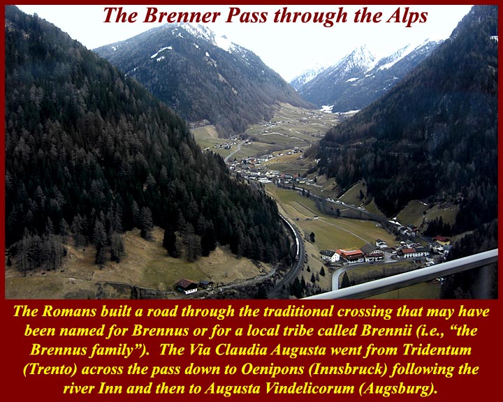
www.mmdtkw.org/AU0308gBrennusFrenchMaritimeSculpture.jpg
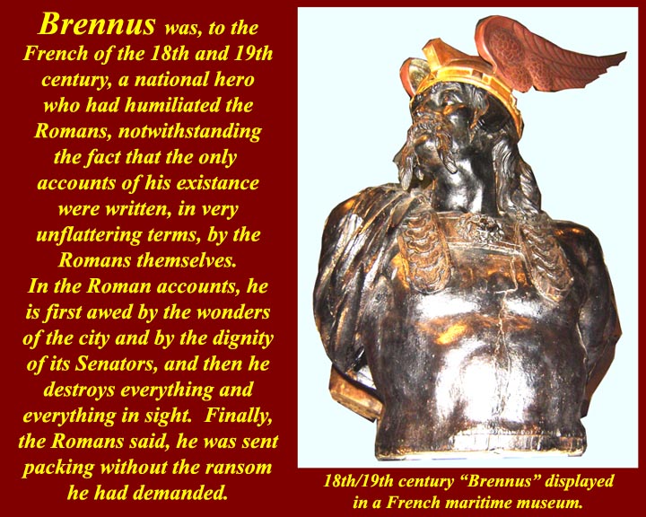
While Brennus I was evil personified to the Romans, he was a hero to transalpine people.
en.wikipedia.org/wiki/Battle_of_the_Allia
"Other Greek and Roman synchronisms have a more obvious historical symbolism, as may be the casewith the Polybian synchronism we saw above, between Dionysius’s siege of
Rhegium and the Gallic sack of Rome."
wxy.seu.edu.cn/humanities/sociology/htmledit/uploadfile/s...
www.unrv.com/empire/gallic-sack-of-rome.php
REFOUNDING THE CITY:
ENNIUS, LIVY, AND VIRGIL
The city of Rome has now been successfully founded in historical time—whether
that time is focalized as Greek or Roman—but we have not yet reached the end of
the story. As everyone knows, the city of Rome kept having to be re-founded, and
the patterns of refoundation drastically reconfigure the trajectory of movement
from myth to history that we have been following so far.188
Ennius’s most explicit surviving allusion to the date of the foundation of the city
in fact comes at the moment when the city had just been virtually destroyed, and
was on the verge of vanishing from history, after the sack by the Gauls in 387/6
b.c.e.189 The context is a speech in which Camillus persuades the Senate not to
move to Veii, but to refound the city instead (154–55 Skutsch):
Septingenti sunt paulo plus aut minus anni
augusto augurio postquam incluta condita Roma est.
It is seven hundred years, a little more or a little less,
since famous Rome was founded by august augury.
How this seven-hundred-year period between Romulus’s foundation and the sack
of Rome by the Gauls actually worked remains a mystery, at least to me.190 Still, we
should not overlook the symbolic significance of this number in its own right. The
importance of the seven-hundred-year period has been very well illustrated in the
fascinating book Die rhetorische Zahl, written by a scholar with the gloriously apt
name of Dreizehnter.191 Dreizehnter does not mention this passage of Ennius, but
he collects a great deal of interesting material about seven hundred years as the life
span of a city or an empire from foundation to extinction, or from foundation to
virtual extinction or only just-escaped extinction. In various traditions that he
examines there were seven hundred years from the foundation to the destruction
of Melos, Carthage, and Macedonia, or from the foundation to the virtual extinc-
(Myth into History I: Foundations of the city)
tion of Sparta.192 What we see in the Ennius passage, in other words, is that the city
was virtually destroyed and came within an ace of fulfilling the seven-hundred year
doom. The point will have been accentuated by Ennius’s book divisions.
Camillus’s speech comes at the end of book 4, and the regal period ended with
book 3, so that up to this point in the Annales we have had only one self-contained
volume of Republican history, and if things had gone differently that might have
been all we had.193
Livy activates the power of this Ennian symbolic numeral, even as he corrects
Ennius’s dating, with his allusion to the seven hundred years of Rome (Pref. 4):
Res est praeterea et immensi operis, ut quae supra septingentesimum annum
repetatur et quae ab exiguis profecta initiis eo creuerit ut iam magnitudine
laboret sua.
In addition, the matter is of immeasurable scope, in that it must be taken back
past the seven hundredth year, and having started from small beginnings has
grown to the stage that it is now laboring under its own size.194
Chaplin has argued that Livy’s preface is constructing recent Roman history as a
death, with a possible rebirth to come:195 the Republic has been destroyed, and the
Romans of Livy’s time are like the Romans of Camillus’s time, faced with the task
of refounding the city after it has only just escaped its seven-hundred-year doom.
In Livy’s treatment of the Roman response to the sack of the city by the Gauls,
we can see him returning to the Ennian theme of rebirth from destruction,
although this time using different significant numbers. Having exploited the numinous
associations of Ennius’s seven hundred years in his preface, Livy now produces
another numinous numeral for the span from foundation to sack, one that
conforms with the modern orthodox chronology. Livy has Camillus deliver a
mighty speech to convince his fellow citizens not to abandon Rome for the site of
Veii (5.51–54).196When Livy’s Camillus echoes Ennius’s by counting off the years
since the foundation, it appears that some kind of great year has gone by. From
Romulus’s foundation down to the sack by the Gauls there have been as many
years as there are days in a year: Trecentensimus sexagensimus quintus annus urbis,
Quirites, agitur (“This is the 365th year of the city, Quirites,” 5.54.5). This is of
course a calculation that fully resonates only after Caesar’s reform of the calendar,
when a Roman year for the first time had 365 days.This counting places
Camillus’s refounding of the city at a pivotal point in time, precisely halfway
(Refounding the City: Ennius, Livy, Virgil . 101)
between the first founding of the city, in 753, and the refounding that faces Livy
and his contemporaries 365 years after Camillus, in the 20s b.c.e.198 Exactly the
same structuring appears to underpin the panorama of Roman history on Virgil’s
Shield of Aeneas, where the barely averted destruction of Rome by the Gauls (Aen.
8.652–62) comes midway in time between the foundation of the city (8.635) and
the barely averted destruction of Rome by Antonius and Cleopatra (8.671–713).199
In all of these authors, city destruction, whether achieved or barely averted,
leads to refoundation and consequent reconfiguring of identity, in a process that
begins with Troy and continues through the fates of Alba Longa, Veii, and Rome
itself.200 As Kraus has shown, when Livy begins his next book after the Gallic sack,
he refounds his narrative along with the city, capitalizing on the annalistic tradition’s
identification of the city and history.201 In an extraordinary moment, the
opening sentences of book 6 tell us that only now is real history beginning. All of
the material in the first five books, Livy now declares, has been “obscure because
of its excessive antiquity” (uetustate nimia obscuras), and because there were few
written records in those early days, while the ones that did exist “for the most part
were destroyed when the city was burnt” (incensa urbe pleraeque interiere, 6.1.2).
Everything up until this point, from Troy to the Gallic sack, is suddenly reconfigured
as prior, prefoundational. In his preface Livy had drawn a line between myth
and history around the time of the Romulean foundation of the city (ante conditam
condendamue urbem, 6), but “the fresh start in 390 redraws the limits of the historically
verifiable.”202We now have a new entry into history, with a newly rebuilt city
and a newly solid evidential base for its written commemoration (6.1.3):
Clariora deinceps certioraque ab secunda origine uelut ab stirpibus laetius
feraciusque renatae urbis gesta domi militiaeque exponentur.
From here there will be a more clear and definite exposition of the domestic
and military history of the city, reborn from a second origin, as if from the
old roots, with a more fertile and fruitful growth.203
Livy here is picking up on the annalistic history of Claudius Quadrigarius, who
had written about fifty years earlier. We know that Claudius began his history with
the sack of Rome by the Gauls, no doubt on the grounds we see alluded to in Livy,
that no history was possible before then, thanks to the destruction of monuments
and archives.204
We have already seen how the Roman tradition picks up demarcations that are
102 . Myth into History I: Foundations of the City
crucial from the Greek tradition—Troy and the first Olympiad—and recasts
them as transitions into a new, Roman, phase of history. The Gallic sack is a vital
addition to this series of watersheds. The first key fixed synchronistic point in
Timaeus and Polybius that makes it possible for Roman history to be properly connected
with Greek history, the Gallic sack is itself made to serve as the “beginning
of history” in Claudius Quadrigarius and Livy book 6.205 The very event that almost
expunged Rome altogether is the one that put the city on the world stage—
just as the destruction of Troy led to the city’s existence in the first place.206
Ovid intuited the power of these associated watersheds of foundation and Gallic
sack, and his subtle deployment of them in the Metamorphoses is proof of their
understood significance. Before he arrives at the foundation of Rome in book 14,
he has a very small number of proleptic references to the as yet nonexistent city.
Book 1 contains two forward references to his own day, with the poem’s first simile
referring to the reign of Augustus (1.199–205), and the story of Apollo and
Daphne likewise anticipating the reign of Augustus, as Apollo prophesies the use
of his sacred laurel to grace Roman triumphs and adorn Augustus’s house (1.560–
63). His only other proleptic references to the city before the foundation in book
14 occur in book 2, and they are both references to the city only just escaping total
catastrophe, catastrophes that would have ensured the city was never part of world
history. One is in a cosmic setting, when the natural site of the city is almost
expunged, as the Tiber is dried up along with other rivers by Phaethon’s chariot
(2.254–59); the other is an allusion to the geese that “were to save the Capitol with
their wakeful cry” (seruaturis uigili Capitolia uoce/ . . . anseribus, 2.538–39).207
Again, in the Fasti, when the gods meet in council to deliberate how to save Rome
from the Gauls, Ovid takes as his template the Ennian council that deliberated over
the foundation of the city: in both cases, Mars expostulates with his father, Jupiter,
and is assured that all will be well.208
It is highly significant that these two events, the city’s foundation and near
destruction by the Gauls, are the only “historical” events commemorated on the
Republican calendar, the Fasti Antiates.209 Calendrical fasti from the Principate
mention all kinds of events, but the Fasti Antiates, the only calendar we have surviving
from the Republic, mark only two historical events: 21 April, the Parilia and
the foundation of the city, and 18 July, the dies Alliensis, the day of the battle of the
Allia, when the Roman army was scattered by the advancing Gauls on their way
to the city, which they entered on the next day.210
The foundation of the city and its near extinction by the Gauls are symbolically
joined events, linked by significant numbers, either 700 or 365, linked by themes of
Refounding the City: Ennius, Livy, Virgil . 103
refoundation and rebirth. The history of the city keeps getting restarted at such
crucial transition moments, when repetitive patterns of quasi-cyclical destruction
and refoundation replay themselves, in a fascinating interplay between a drive for
onward narrative continuity and the threat of eddying, repetitious, circularity.211 It
is poignant to observe the power of this theme still persisting in the fifth century
c.e., when Rutilius Namatianus, six years after the sack of Rome by the Visigoths
in 410 c.e., can hail Rome’s potential to bounce back from disaster, citing its eventual
defeat of Brennus, who led the Gauls to the sack of Rome, and of the Samnites,
Pyrrhus, and Hannibal:212 “You, Rome, are built up,” he claims, “by the very thing
that undoes other powers: the pattern of your rebirth is the ability to grow from
your calamities” (illud te reparat quod cetera regna resoluit:/ordo renascendi est
crescere posse malis, 139–40). Each of these key marker moments in time may become
a new opportunity for the community to reimagine itself, as the epochal moment
produces a new beginning point from which the community may imagine its
progress forward into time, measured against its backward extension into time.213
_______________________________ __________________________
The Gauls in the Italia peninsula .Clusium was reached by the Gauls, who had invaded most of Etruria already, and its people turned to Rome for help. However, the Roman embassy provoked a skirmish and, then, the Gauls marched straight for Rome (July, 387 BC). After the entire Roman army was defeated at the Allia brook (Battle of the Allia), the defenseless Rome was seized by the invaders. The entire Roman army retreated into the deserted Veii whereas most civilians ended at the Etruscan Caere. Nonetheless, a surrounded Roman garrison continued to resist on the Capitoline Hill. The Gauls dwelt within the city, getting their supplies by destroying all nearby towns for plunder.When the Gauls went for Ardea, the exiled Camillus, who was now a private man, organized the local forces for a defense. Particularly, he harangued that, always, the Gauls exterminated their defeated enemies. Camillus found that the Gauls were too distracted, celebrating their latest spoils with much 'crapulence' at their camp. Then, he attacked during a night, defeating the enemy easily with great bloodshed.He is thus considered the second founder of Rome.Camillus was hailed then by all other Roman exiles throughout the region. After he refused a makeshift generalship, a Roman messenger sneaked into the Capitol and, therein, Camillus was officially appointed dictator by the Roman Senators, to confront the Gauls.At the Roman base of Veii, Camillus gathered a 12,000-man army whereas more men joined out of the region. The occupying Gauls were in serious need, under quite poor health conditions. As the Roman Dictator, Camillus negotiated with the Gallic leader Brennus, and the Gauls left Rome, camping nearby at the Gabinian road. A day after this, Camillus confronted them with his refreshed army and the Gauls were forced to withdraw, after seven months of occupation (386 BC).
Camillus sacrificed for the successful return and he ordered the construction of the temple of Aius Locutius. Then, he subdued another claim of the plebeian orators, who importuned further about moving to Veii. After ordering a Senate debate, Camillus argued for staying and the Roman house approved this unanimously. The reconstruction extended for an entire year.
By this one-year office, Camillus was the longest of all Roman dictators. Basically, the Senators had been persuaded by the disturbing social clashes, which could be better managed by Camillus. Instead, Camillus disliked this and, vainly, he requested the dismissal.
Roman dictator (367 BC)
As the Gauls were, again, marching toward Latium, all Romans reunited despite their severe differences. Camillus was named Roman dictator for the fifth time then (367 BC). He organized the defense of Rome actively. By the commands of Camillus, the Roman soldiers were protected particularly against the Gallic main attack, the heavy blow of their swords. Both smooth iron helmets and brass rimed shields were built. Also, long pikes were used, to keep the enemy's swords far.
The Gauls camped at the Anio river, carrying loads of recently gotten plunder. Near them, at the Alban Hills, Camillus discovered their disorganization, which was due to unruly celebrations. Before the dawn, then, the light infantry disarrayed the Gallic defenses and, subsequently, the heavy infantry and the pikemen of the Romans finished their enemy. After the battle, Velitrae surrendered voluntarily to Rome. Back in Rome, Camillus celebrated with another Triumph.
ancientimes.blogspot.co.nz/2007/06/brennus-and-first-sack...
A deadly pestilence struck Rome and it affected most Roman public figures. Camillus was amongst them, passing away in 365 BC.
Source: Plutarch, The Parallel Lives - The Life of Camillus:
In popular culture
Marcus Furius Camillus was played by Massimo Serato in the 1963 film 'Brennus, Enemy of Rome'.
www.flickr.com/photos/ggnyc/1405297848/
BC 400's Celts from the Alps flowed into Italy ....
Herodotus of Halicarnassus reported a merchant from Samos named Colacus was driven off course by tides and winds when trading off the African shore. He landed at the Tartessus (modern River Guadalquivir in southern Spain) where he found tribes of Keltoi working the silver mines
396 BC Celts defeated the Etruscans at Melpum (Melzo, west of Milan)
390 Senones Celts ('the veterans') led by Brennos (Latinate: Brennus) defeated the Romans in Rome (July 19) so badly it took the Romans 200 years to recover from the 'terror Gallicus'. After seven months and a ransom of 100 pounds of gold, the Celts moved along to Picenum on Italy's eastern seaboard.
Ephoros of Cyme reported the Celts occupied an area the size of the Indian sub-continent.
334-335 Alexander of Macedonia met the Celts on the Danube banks to make an agreement: The Celts would not attack his empire while he was off conquering in the east. Only after his death they expanded to Moravia and Thrace .
----------- ----------
Along with Bolgios, Brennos II was the legendary leader of other Celts on their invasion of Macedonia in the second century BCE. Though Bolgios led the invasion of Macedonia , Brennus succeeded in crossing his whole army over the river Sperchios into Greece proper, where he laid seige to the town of Heraclea and, having driven out the garrison there, marched on to Thermopylae where he defeated an army raised by a confederation of Greek cities. Brennus then avanced across Greece, where he decided to go on to Delphi, which was reported as the treasure house of Greece. Brennus and his army of 30,000 set off to attack the temple of Apollo, the ultimate goal of his expedition. Here it is said that Brennos was defeated by earthquakes and thunderbolts that reduced the soldiers to ashes; snow storms, showers of great stones, and "ancient heroes appearing from the heavens". In the midst of this snowstorm, Brennos and his men were attacked near the Parnassus mountains. The Celts were soundly defeated and Brennos was mortally wounded. As he lay dying, he gave the order for all of the wounded to be killed, and all the booty to be burned, as the army would never make it home if they had to carry the wounded warriors and their plunder. After giving the order, Brennos drank some wine and then took his own life. (? Source)
www.maryjones.us/ctexts/classical_pausianas.html
The Description of Greece
Pausanias (fl. 2nd c. CE) XIX.
[5] "I have made some mention of the Gallic invasion of Greece in my description of the Athenian Council Chamber. But I have resolved to give a more detailed account of the Gauls in my description of Delphi, because the greatest of the Greek exploits against the barbarians took place there. The Celts conducted their first foreign expedition under the leadership of Cambaules. Advancing as far as Thrace they lost heart and broke off their march, realizing that they were too few in number to be a match for the Greeks. "...........
10]" When the Gallic horsemen were engaged, the servants remained behind the ranks and proved useful in the following way. Should a horseman or his horse fall, the slave brought him a horse to mount; if the rider was killed, the slave mounted the horse in his master's place; if both rider and horse were killed, there was a mounted man ready. When a rider was wounded, one slave brought back to camp the wounded man, while the other took his vacant place in the ranks.
[11] I believe that the Gauls in adopting these methods copied the Persian regiment of the Ten Thousand, who were called the Immortals. There was, however, this difference. The Persians used to wait until the battle was over before replacing casualties, while the Gauls kept reinforcing the horsemen to their full number during the height of the action. This organization is called in their native speech trimarcisia, for I would have you know that marca3 is the Celtic name for a horse. "
(Addit :we know from Celtic myth this was indigenous to the confederacy of Celtic tribes as on Gundestrup Cauldron ,warrior plate)
[12] "This was the size of the army, and such was the intention of Brennos, when he attacked Greece. The spirit of the Greeks was utterly broken, but the extremity of their terror forced them to defend Greece. They realized that the struggle that faced them would not be one for liberty, as it was when they fought the Persian, and that giving water and earth would not bring them safety. They still remembered the fate of Macedonia, Thrace and Paeonia during the former incursion of the Gauls, and reports were coming in of enormities committed at that very time on the Thessalians. So every man, as well as every state, was convinced that they must either conquer or perish. "
Attalus I (Greek: Ἄτταλος), surnamed Soter (Greek: Σωτὴρ, "Savior"; 269 BC – 197 BC) ruled Pergamon, an Ionian Greek polis (what is now Bergama, Turkey), first as dynast, later as king, from 241 BC to 197 BC. He was the second cousin and the adoptive son of Eumenes I, whom he succeeded, and was the first of the Attalid dynasty to assume the title of king in 238 BC.He was the son of Attalus and his wife Antiochis.
Attalus won an important victory over the Galatians, newly arrived Celtic tribes from Thrace, who had been, for more than a generation, plundering and exacting tribute throughout most of Asia Minor without any serious check. This victory, celebrated by the triumphal monument at Pergamon, famous for its 'Dying Galatian' or 'Gaul' statue , and the liberation from the Gallic "terror" which it represented, earned for Attalus the name of "Soter", and the title of "king". A courageous and capable general and loyal ally of Rome, he played a significant role in the first and second Macedonian Wars, waged against Philip V of Macedon.
Etymologically Brennos is related to Brân and is related to the reconstructed proto-Celtic lexical elements *brano- (raven) -n- (the deicific particle) and os (the masculine ending). Thus Brennos is literally the 'Raven God'. However, the bren part of the name is also the root for one Cymric word for king brenhin and Brennos can be rendered as 'Raven King'. Which also leads to the supposition that 'Brennos', rather than being a proper name is actually an honorific denoting 'battle lord'. Raven gods being tribal leaders in the time of war so a Celtic war leader would take-on the name of such a deity. Indeed, the modern Cymric for king is brenin a word derived from 'Brennos'.
An actual late Iron Age helmet like this has been located in ancient Dacia , Translyvania , now modern Roumania/ Romania the Helmet of Ciumeşti.
www.flickr.com/photos/42003310@N05/4886860352/
As one of the styles depicted on the Celtic Gundestrup Cauldron.
Wilcox and McBride mentioned that their illustration of the iron Gallic warrior's helmet of the middle La Tene period had been reconstructed the on the basis of the Ciumesti helmet.[45]
A small portion of the snow geese that descended upon a lake near Grand Island Nebraska.
Two more photos from this scene:
Multitudes -- this one is a panorama of the whole scene.
I once heard that the ospreys arrive here around St Patrick's Day and they leave around Labor Day. So, it seems that they are getting ready to leave.
well what can I say...great day with Blingsister (Mel)
at the Reifle Bird Sanctuary...these birds are evidence of the paintbrush of nature ...this is the normal /standard wood duck shot later I hope to post some in different not so common poses.
Thanks for comments and favs////but mostly just taking a boo...all appreciated!
This is still a Shell garage today with only small changes - the garage next door is now a Peugeot dealer whereas it was a Nissan dealer here and the Shell pole sign migrated from one end of the site to the other - apart from that only the usual changes in livery style and some newer pump equipment in the last thirty years. www.google.com/maps/@53.0278392,-2.1891398,3a,75y,151.04h...
About once a year hundreds of monarch butterflies migrate for a day or so through our town. Many of them choose the luscious colourful garden belonging to friends of ours as brief rest & feeding stop. I was invited over yesterday to try to capture some of this glory.
I have just started to experiment with the X-Rite ColorChecker Passport which is designed to improve and simplify capture of accurate colours: For more info: xritephoto.com/ph_product_overview.aspx?id=1257&catid...
For a fascinating read on the amazing migration of the monarch butterfly, please see: www.worldwildlife.org/species/finder/monarchbutterflies/m...
Please click on image to view Large on black.