Taiwanese 臺灣人
View allAll Photos Tagged Information_system
IS/IT ©2018r hahs all rights reserved ( Information systems/Information technology ) Abstract = software\hardware
Ein Stockwerkschaltapprat (auch unter anderen Namen wie Kopierapparat bekannt) war früher Teil einer Aufzugsanlage. Er bildete die Position und Bewegung der Aufzugkabine in Relation zu wichtigen Merkmalen des Aufzugsschachts, insbesondere der Haltepunkte an den Stockwerken, elektromechanisch ab. Seine Schaltkontakte waren mit einer relaisbasierten Aufzugssteuerung verbunden. Heute üblich sind Schachtinformationssysteme, welche auf einer Echtzeit-Messung der Kabinenposition im Aufzugsschacht basieren.
---
A floor switch apparatus (also known under different names such as copying apparatus) used to be part of an elevator system. It mapped the position and movement of the elevator car in relation to important features of the hoistway, in particular the landings at the floors in an electro mechanical manner. Its switching contacts were coupled to a relay-based elevator controller. The state-of the art solution is a hoistway information system that is based on real-time measurement of the car position in the hoistway.
EB 3240 of DSB is the 1000th Vectron. Tonight it was out for the very first time with a rake of double-deck cars. Note the passenger information system saying "Do not board this train", as these are only test drives.
🇩🇰 To learn more about Siemens' Vectron 1000, check out this article on Railcolor News: railcolornews.com/2021/11/02/eu-1000-tak-1000-vectrons-si...
Happy Fly Day Friday!
Also, in case you're wondering,
"Tracing the origin of the common name for Melampodium leucanthum (blackfoots) stems from the origin of the botanical genus name. Take a look at the Wikipedia website under the genus, Melampodium and you will find the following information... 'The name is derived from the Greek words μέλας (melas), meaning "black", and πόδιον (podion), meaning "foot."' This refers to the color of the base of the stem and roots. Referenced from Quattrocchi, Umberto (2000). CRC World Dictionary of Plant Names. III: M-Q. CRC Press. p. 1647. ISBN 978-0-8493-2677-6. Members of the genus are commonly known as blackfoots.” Referenced from "Melampodium" in the Integrated Taxonomic Information System."
#KyivNotKiev 17 Июня 2019 года Совет США по географическим названиям (англ. United States Board on Geographic Names, BGN) исправил в Информационной системе географических названий (англ. Geographic Names Information System, GNIS) — база данных стандартизованных наименований географических объектов, наименование столицы Украины.
Из летописей известно, что «Киев» всегда назывался «Кыевом», его горожане были не «киевляне», а «кыяне», древняя речка на территории города – не «Лебедь», а «Лыбидь». То, что произошло, – это возвращение в иностранных текстах к историческому украинскому произношению,
И таки Да, стремление использовать собственные топонимические названия, - это некоторый элемент культурной войны за независимость и национальную идентичность. Это влияет на сознание и психологию людей, контекст языка общения – формирует мировоззрение.
Loramie Creek is a 40.0-mile-long tributary of the Great Miami River in western Ohio. Via the Great Miami and Ohio rivers, it is part of the watershed of the Mississippi River, draining an area of 265 square miles. According to the Geographic Names Information System, the stream has also been known historically as "Laramie Creek," "Loramie Ditch," "Loramies Creek," and "Lonamie Creek.". It is named after Louis Lorimier, a French-Canadian fur trader who had a trading post in the area in the 18th century.
Amphicnemis gracilis
Identification faite grâce à mybis.gov.my (Malaysia Biodiversity Information System), site que nous recommandons vivement!
Gunung Mulu NP, Sarawak, Borneo, Malaisie
Identified thanks to mybis.gov.my (Malaysia Biodiversity Information System), a website that we highly recommend!
Gunung Mulu NP, Sarawak, Borneo, Malaysia
050628-N-0000X-001
Navy file photo of Navy SEALs operating in Afghanistan in support of Operation Enduring Freedom. From left to right, Sonar Technician (Surface) 2nd Class Matthew G. Axelson, of Cupertino, Calif; Senior Chief Information Systems Technician Daniel R. Healy, of Exeter, N.H.; Quartermaster 2nd Class James Suh, of Deerfield Beach, Fla.; Hospital Corpsman 2nd Class Marcus Luttrell; Machinist?s Mate 2nd Class Eric S. Patton, of Boulder City, Nev.; and Lt. Michael P. Murphy, of Patchogue, N.Y. With the exception of Luttrell, all were killed June 28, 2005, by enemy forces while supporting Operation Red Wing. U.S. Navy photo (RELEASED)
Keewaydin Island is a primary barrier island located off the coast of Naples, in Collier County, Florida, United States. It is managed by the State of Florida's Coastal Office, in cooperation with NOAA, within the Rookery Bay National Estuarine Research Reserve. Keewaydin Island is monitored nightly for Loggerhead turtle nesting activity by The Conservancy of Southwest Florida.
The Keewaydin Island shoreline has been mapped annually since 1997 in an effort to document shoreline change. The shoreline is also mapped after significant storm events. Mapping is done by collecting Global Positioning System locations along the dune-line and then downloaded using Geographic information system software.
Keewaydin Island was once a part of the Keewaydin Camps Ltd. corporation. Originally, the island was named Kee Island, and once the Keewaydin Camps had a presence here, it became known as Keewaydin Island. The island is currently about 85% public property and 15% private. Approximately 50 private lots and 15 private homes dot the island, located on the west side of the island close to the beachfront. Marco Island can be seen from the southern tip of Keewaydin.
"To reach this island there are no bridges, highways, roads or trails, is only one way to get here and it is by the sea"
Lots of containers, presumably need quite good information systems to find a particular one. 66197 at the headhunt, has bought in 4M35 from Mossend.
The Grade I Listed Bodleian Library, in Oxford, Oxfordshire.
The Bodleian Library is the main research library of the University of Oxford, is one of the oldest libraries in Europe. With over 12 million items, it is the second biggest library in Britain after the British Library. Under the Legal Deposit Libraries Act 2003 it is one of six legal deposit libraries for works published in the United Kingdom and under Irish Law it is entitled to request a copy of each book published in the Republic of Ireland. Known to Oxford scholars as "Bodley" or "the Bod", it operates principally as a reference library and in general, documents may not be removed from the reading rooms.
In 2000, several libraries within the University of Oxford were brought together for administrative purposes under the aegis of what was initially known as Oxford University Library Services (OULS), and since 2010 as the Bodleian Libraries, of which the Bodleian Library is the largest component.
All colleges of the University of Oxford have their own libraries, which in several cases were established well before the foundation of the Bodleian, and all of which remain entirely independent of the Bodleian. They do, however, participate in OLIS (Oxford Libraries Information System), the Bodleian Libraries' online union catalogue.
In November 2015 its collections topped 12 million items with the acquisition of Shelley's "POETICAL ESSAY on the EXISTING STATE OF THINGS". Thought lost from shortly after its publication in 1811 until a copy was rediscovered in a private collection in 2006.
Information Source:
Coyotes are members of the Canidae family and share a lot of the same traits of their relatives: wolves, dogs, foxes and jackals. There are 19 subspecies of coyote, according to the Integrated Taxonomic Information System. They have narrow, elongated snouts, lean bodies covered in thick fur, yellow or amber eyes and long, bushy tails. Coyotes have gray, white, tan and brown fur. Their fur color depends on where they live. Coyotes that live in the mountains have darker coats and ones that live in the desert have lighter coats.
The InciWeb Incident Information System is following 18 fires in Alaska that are contributing, along with 49 uncontrolled fires under surveillance by the Canadian Wildland Fire Information System, to vast areas of visible smoke throughout Canadian provinces and stretching into northern U.S. states. This image from the Suomi NPP satellite's VIIRS instrument was taken from NOAA View on June 28, 2015. The smoke from these fires can also be seen in NOAA View as Aerosol Optical Thickness, a measure of how aerosols, such as smoke from wildfires, scatter and absorb sunlight.
Credit: NOAA/NASA GOES Project
NASA Goddard Space Flight Center enables NASA’s mission through four scientific endeavors: Earth Science, Heliophysics, Solar System Exploration, and Astrophysics. Goddard plays a leading role in NASA’s accomplishments by contributing compelling scientific knowledge to advance the Agency’s mission.
Follow us on Twitter
Like us on Facebook
Find us on Instagram
I recently met Ezra in Birmingham. He has such a sunny personality and recently graduated in Information Systems Management and Cyber Security.
APRA HARBOR, Guam (Sept. 28, 2021) Information Systems Technician 3rd Class Tyler Houser, from Polk County, Florida, stands topside rover watch on the flight deck aboard Independence-variant littoral combat ship USS Charleston (LCS 18). Charleston, part of Destroyer Squadron 7, is on a rotational deployment, operating in the U.S. 7th Fleet to enhance interoperability with partners and serve as a ready-response force in support of a free and open Indo-Pacific region. (U.S. Navy photo by Mass Communication Specialist 2nd Class Ryan M. Breeden)
Boston Common
From Wikipedia, the free encyclopedia
For other uses, see Boston Common (disambiguation).
Boston Common
U.S. National Register of Historic Places
U.S. National Historic Landmark District
Boston common 1848.jpg
View of the water celebration on Boston Common on October 25, 1848
Boston Common is located in Boston Boston Common
Show map of Boston
Show map of Massachusetts
Show map of the US
Show all
LocationBoston, Massachusetts
Area50 acres (200,000 m2)[1]
Built1634
ArchitectMultiple, including Augustus St. Gaudens
NRHP Reference #72000144 (original)
87000760 (new)
Significant dates
Added to NRHPJuly 12, 1972 (original, in NRHP also including Boston Public Garden)
February 27, 1987 (new, in NHL of Boston Common alone)[2]
Designated NHLDFebruary 27, 1987[3]
Boston Common (also known as the Common) is a central public park in downtown Boston, Massachusetts. It is sometimes erroneously referred to as the "Boston Commons".[4][5] Dating from 1634, it is the oldest city park in the United States.[6] The Boston Common consists of 50 acres (20 ha) of land bounded by Tremont Street, Park Street, Beacon Street, Charles Street, and Boylston Street. The Common is part of the Emerald Necklace of parks and parkways that extend from the Common south to Franklin Park in Jamaica Plain, Roxbury, and Dorchester. A visitors' center for all of Boston is located on the Tremont Street side of the park.
Aerial view in 2017
The Central Burying Ground is located on the Boylston Street side of Boston Common and contains the burial sites of the artist Gilbert Stuart and the composer William Billings. Also buried there are Samuel Sprague and his son, Charles Sprague, one of America's earliest poets. Samuel Sprague was a participant in the Boston Tea Party and fought in the Revolutionary War. The Common was designated as a Boston Landmark by the Boston Landmarks Commission in 1977.
Contents [hide]
1History
2Notable features
2.1Grounds
2.2Structures
2.3Neighboring structures
3Notable recurring events
4See also
5References
6Further reading
7External links
History[edit]
African-American artist Edward Mitchell Bannister painted this vivid depiction of the street and Boston Common area in 1898-99.[7]
The Common's purpose has changed over the years. It was once owned by William Blaxton (often given the modernized spelling "Blackstone"), the first European settler of Boston, until it was bought from him by the Puritan founders of the Massachusetts Bay Colony. During the 1630s, it was used by many families as a cow pasture. However, this only lasted for a few years, as affluent families bought additional cows, which led to overgrazing, a real-life example of the Tragedy of the commons.[8] After grazing was limited in 1646 to 70 cows at a time,[9] the Boston Common continued to host cows until they were formally banned from it in 1830 by Mayor Harrison Gray Otis.[10]
Execution of Ann Hibbins on Boston Common, on charges of witchcraft, June 19, 1656. Sketch by F.T. Merril, 1886
The Common was used as a camp by the British before the American Revolutionary War, from which they left for the Battle of Lexington and Concord. It was used for public hangings up until 1817, most of which were from a large oak which was replaced with a gallows in 1769. On June 1, 1660, Quaker Mary Dyer was hanged there by the Puritans for repeatedly defying a law that banned Quakers from the Colony.[11] Dyer was one of the four Quakers executed on the Common and known as the Boston martyrs.[12][13]
On May 19, 1713, two hundred citizens rioted on the Common in reaction to a food shortage in the city. They later attacked the ships and warehouses of wealthy merchant Andrew Belcher, who was exporting grain to the Caribbean for higher profits. The lieutenant governor was shot during the riot.[14]
Central Burying Ground on Boston Common
1890 Map of Boston Common and the adjacent Public Garden
True park status seems to have emerged no later than 1830, when the grazing of cows was ended and renaming the Common as Washington Park was proposed. Renaming the bordering Sentry Street to Park Place (later to be called Park Street) in 1804[15] already acknowledged the reality. By 1836, an ornamental iron fence fully enclosed the Common and its five perimeter malls or recreational promenades, the first of which, Tremont Mall, had been in place since 1728, in imitation of St. James's Park in London. Given these improvements dating back to 1728, a case could be made that Boston Common is in fact the world's first public urban park, since these developments precede the establishment of the earliest public urban parks in England—Derby Arboretum (1840), Peel Park, Salford (1846), and Birkenhead Park (1847)—which are often considered the first.
Originally, the Charles Street side of Boston Common, along with the adjacent portions of the Public Garden, were used as an unofficial dumping ground, due to being the lowest-lying portions of the two parks; this, along with the Garden's originally having been a salt marsh, resulted in the portions of the two parks being "a moist stew that reeked and that was a mess to walk over", driving visitors away from these areas. Although plans had long been in place to regrade the Charles Street-facing portions of Boston Common and the Public Garden, the cost of moving the amount of soil necessary (approximately 62,000 cu yd (47,000 m3), weighing 93,000 short tons (84,000,000 kg), for the Common, plus an additional 9,000 cu yd (6,900 m3), weighing 14,000 short tons (13,000,000 kg), for the adjoining portions of the Public Garden) prevented the work from being undertaken. This finally changed in the summer of 1895, when the required quantity of soil was made available as a result of the excavation of the Tremont Street Subway, and was used to regrade the Charles Street sides of both Boston Common and the Public Garden.[16]
A hundred people gathered on the Common in early 1965 to protest the Vietnam War. A second protest happened on October 15, 1969, this time with 100,000 people protesting.[17]
Today, the Common serves as a public park for all to use for formal or informal gatherings. Events such as concerts, protests, softball games, and ice skating (on Frog Pond) often take place in the park. Famous individuals such as Martin Luther King Jr. and Pope John Paul II have made speeches there. Judy Garland gave her largest concert ever (100,000+) on the Common, on August 31, 1967.
It was declared a U.S. National Historic Landmark in 1987.[1][3] The Boston Common is a public park managed by the Boston Park Department. A private advocacy group, the Friends of the Public Garden, provides additional funding for maintenance and special events.[18]
On October 21, 2006, the Common became the site of a new world record, when 30,128 Jack-o'-lanterns were lit simultaneously around the park at the Life is good Pumpkin Festival.[19] The previous record, held by Keene, New Hampshire since 2003, was 28,952.[20]
On August 27, 2007, two teenagers were shot on the Common. One of the bullets fired during the shooting struck the Massachusetts State House.[21] A strict curfew has since been enforced, which has been protested by the homeless population of Boston.[22][23]
Notable features[edit]
Boston Common in the fall of 2016.
Grounds[edit]
The Common forms the southern foot of Beacon Hill.
Boston Common is the southern end of Boston's Freedom Trail.
The softball fields lie in the southwest corner of the Common.
A grassy area forms the western part of the park and is most commonly used for the park's largest events. A parking garage lies under this part of the Common. A granite slab there commemorates Pope John Paul II's October 1979 visit to Boston.
In 1913 and 1986 prehistoric sites were discovered on the Common indicating Native American presence in the area as far back as 8,500 years ago.[24]
Since 1971 the Province of Nova Scotia has donated the annual Christmas Tree to the City of Boston as an enduring thank-you for the relief efforts of the Boston Red Cross and the Massachusetts Public Safety Committee following the Halifax Explosion of 1917. In recent years[when?] the tree has been located[where?] on the Common.
Structures[edit]
A monumental inscription at the corner of Park Street and Tremont Street reads:[citation needed]
In or about the year of our Lord One Thousand Six Hundred thirty and four the then present inhabitants of the Town of Boston of whom the Hon John Winthrop Esq Gov of the Colony was Chiefe did treat and agree with Mr William Blackstone for the purchase of his Estate and any Lands living within said neck of Land called Boston after which purchase the Town laid out a plan for a trayning field for which ever since and now is used for that purpose and for the feeding of cattell.
Plaque to the Great Elm tree, which had been adorned with lanterns to represent liberty, used as a point of fortification, and used for hangings.[25] It was destroyed in a storm in 1876.
The Robert Gould Shaw Memorial to Robert Gould Shaw and the Afro-American 54th Massachusetts Volunteer Infantry stands at Beacon and Park Streets, the northeast corner of the Common, opposite the State House.
The Soldiers and Sailors Monument is a victory column on Flag Staff Hill in the Common, commemorating Civil War dead.
The Boston Massacre Memorial was dedicated November 14, 1888.
The Oneida Football Monument memorializes the Common as the site of the first organized football games in the United States, played by the Oneida Football Club in 1862.[26]
Frog Pond, a public ice-skating rink in winter months, is situated in the northern portion.
Brewer Fountain stands near the corner of Park and Tremont Streets, by Park Street Station. The 22-foot-tall (6.7 m), 15,000-pound (6,800 kg) bronze fountain, cast in Paris, was a gift to the city by Gardner Brewer. It began to function for the first time on June 3, 1868.
Boylston and Park Street stations, the first two subway stations in the Western Hemisphere, lie underneath the southern and eastern corners of the park, respectively; both stations have been in near-continuous operation since the opening of the first portion of the Tremont Street Subway (now part of the MBTA's Green Line) on 1 September 1897.
Parkman Bandstand, in the eastern part of the park, is used in musical and theatrical productions.
Beacon St. Mall, 19th century (photo by E.L. Allen)
Old Elm tree, 19th century
Plaque to the Great Elm tree
Memorial to Robert Gould Shaw and the Massachusetts Fifty-Fourth Regiment
Soldiers and Sailors Monument
Boston Massacre Memorial
The Frog Pond
Parkman Bandstand
Massachusetts State House/Massachusetts Statehouse ("New" State House)
Boylston station
Boston Common
Neighboring structures[edit]
The Massachusetts State House stands across Beacon Street from the northern edge of the Common.
The Boston Public Garden, a more formal landscaped park, lies to the west of the Common across Charles Street (and was originally considered an extension of the Common).
The Masonic Grand Lodge of Massachusetts headquarters sits across from the southern corner of the Common at the intersection of Boylston and Tremont Streets.
Across from the southern corner of the Common, along Boylston and Tremont Streets, lies the campus of Emerson College.
Across from the Common, to the southeast, Suffolk University has a dormitory on Tremont Street.
Notable recurring events[edit]
Commonwealth Shakespeare Company's Shakespeare on the Common
Boston Lyric Opera's Outdoor Opera Series
Ancient Fishweir Project Installation Event
Massachusetts Cannabis Reform Coalition's Freedom Rally
Lighting of the Christmas tree gifted by Halifax, Nova Scotia.
Fireworks display on the evening of December 31 as part of Boston's First Night celebration
See also[edit]
Boston portal
Boston martyrs
Granary Burying Ground
King's Chapel burying ground
Boston Public Garden
List of National Historic Landmarks in Boston
National Register of Historic Places listings in northern Boston, Massachusetts
References[edit]
^ Jump up to: a b James H. Charleton (November 1985). "National Register of Historic Places Inventory-Nomination: Boston Common" (PDF). National Park Service. Retrieved 2009-06-22. and Accompanying photos: one aerial from 1972 and three from 1985 (1.43 MB)
Jump up ^ National Park Service (2007-01-23). "National Register Information System". National Register of Historic Places. National Park Service.
^ Jump up to: a b "Boston Common". National Historic Landmark summary listing. National Park Service. Retrieved 2008-04-16.
Jump up ^ "Boston Common". City of Boston. Retrieved 2011-11-09.
Jump up ^ "Place Names: Boston English". Adam Gaffin and by content posters. Retrieved 2011-11-09.
Jump up ^ "Boston Common". CelebrateBoston.com. 2006. Retrieved 2011-03-26.
Jump up ^ "Boston Street Scene (Boston Common)". The Walters Art Museum.
Jump up ^ Loewen, James (1999). Lies Across America: What Our Historic Sites Get Wrong. New York: The New Press. p. 414. ISBN 0-9650031 -7-5.
Jump up ^ Boston Common & Public Gardens - Great Public Spaces | Project for Public Spaces. PPS. Retrieved on 2013-08-21.
Jump up ^ Lowen, James (1994) Planning the City Upon a Hill: Boston Since 1630University of Massachusetts Press (Boston) ISBN 0-87023-923-6, ISBN 978-0-87023-923-6, p. 53
Jump up ^ Rogers, Horatio, 2009. Mary Dyer of Rhode Island: The Quaker Martyr That Was Hanged on Boston pp.1–2. BiblioBazaar, LLC
Jump up ^ J. Besse, A Collection of the Sufferings of the People called Quakers, 1753, Vol. 2, pp. 203-05.
Jump up ^ ODNB article by John C. Shields, ‘Leddra, William (d. 1661)’, Oxford Dictionary of National Biography, Oxford University Press, Sept 2004; online edn, May 2007 [1], accessed 16 Aug 2009
Jump up ^ Zinn, Howard. A People's History of the United States. New York: Perennial, 2003. p.51 ISBN 0-06-052837-0
Jump up ^ "A Brief History of the Union Club". The Union Club of Boston. Retrieved 4 October 2012.
Jump up ^ Most, Doug (2014). The Race Underground: Boston, New York, and the Incredible Rivalry that Built America's First Subway. St. Martin's Press. pp. 233–234. ISBN 978-1-250-06135-5.
Jump up ^ Zinn, Howard. p.486
Jump up ^ www.friendsofthepublicgarden.org
Jump up ^ "Life is good" site Archived March 9, 2008, at the Wayback Machine.
Jump up ^ Levenson, Michael; McCabe, Kathy (October 22, 2006). "A love in Common for pumpkins". The Boston Globe.
Jump up ^ Drake, John C. (August 28, 2007). "Shots on Common strike teens, State House". The Boston Globe.
Jump up ^ Abel, David (August 30, 2007). "Curfew targets crime on Common". The Boston Globe.
Jump up ^ "Homeless Protest Boston Common Curfew: Park Closed After 11 P.M.". TheBostonChannel.Com. 2007-08-30. Retrieved 2008-04-16.
Jump up ^ Research at Boston University. Bu.edu (2007-01-10). Retrieved on 2013-08-21.
Jump up ^ www.celebrateboston.com/sites/boston-common-great-elm.htm. Missing or empty |title= (help)
Jump up ^ Winthrop Saltonstall Scudder, An historical sketch of the Oneida football club of Boston, 1862-1865 (Boston, 1926)
The brand new fleet of service 26 vehicles have been installed with a new stop information system with the top screen displaying stop and connection information and the lower screen displaying twitter updates and special events. 28th July 2017.
Some architecture with my new 43 years old Carl Zeiss 4/50 Distagon
Hasselblad 500 C/M
Carl Zeiss C 4/50 Distagon
CFV-50c
Haida 150mm GND
PACIFIC OCEAN (May 10, 2021) Information Systems Technician 3rd Class Logan Agler, left, from Liberty Township, Ohio, and Mineman 1st Class Nicholas Butler, from Indianapolis, remove chocks and chains from an MH-60S Sea Hawk helicopter assigned to Helicopter Sea Combat Squadron 21 aboard Independence-variant littoral combat ship USS Charleston (LCS 18) during flight quarters. Charleston is currently operating in U.S. 3rd Fleet. (U.S. Navy photo by Mass Communication Specialist 3rd Class Adam Butler)
In life, we tended to resist change. SJMC had just gone through one with the implementation of the computerised Hospital Management and Information System - dubbed the HMIS. I was on call on the moment of implementation - midnight on 1st October 2016 - but the system remained off line until I finished my shift. The moment it became online, the mayhem started.
The management decided to close all outpatient clinic - although some did not have the choice but to remain opened. I did not bother since it was my post-call morning and I have got the photo walk lined up. I came to join the party later on that afternoon after the fun subsided.
There were plenty of kinks over the weekend, but it was helped by the Monday off for Awal Muharram. It is the first day of full day since the implementation today. I still had my clinic closed since I would be in Hospital Ampang examining, away from it all …..
Since I was using the same system at Park City and Ara Damansara, I understood the problems, but my worry was not on my side, but on the network itself. Would it be able to handle the stress and the workload? We could only wait and pray …..
Blogged here.
“EARLY SPACEMEN—Engineers test spacesuit flexibility in mockup of full scale Apollo spacecraft command module at North American’s Space and Information Systems Division, Downey, Calif. Apollo spacecraft command and service modules are produced at Downey for NASA’s Manned Spacecraft Center, Houston.”
Yet again…I’ve seen this image many-a-time while searching for something else. Of course, right now, intentionally trying to find it; zip, nada, zilch. And that’s using reverse image & multiple keyword combination searches. UGH. If I recall correctly, it was primarily published in a generic press release capacity. Even if in NASA publication(s), accompanied only by something similar to the above.
Regardless, I believe one of these gentlemen conducted a simulated two-week mission using a Block I CM inside a vacuum chamber at the company’s Downey, California facility. That being John Moyles on the far left. In the center, with the steely-eyed gaze – and possibly no couch? – is Wallace Johnson. I haven’t a clue who’s to the back left. The first & stand-alone letter of his name tab appears to be an 'M."
Finally, neither here nor there, but the amazing resolution reveals the International Latex Corp. logo on the back of Mr. Moyles’ right-hand glove. Along that line, see also:
Wallace Johnson, outstanding:
abc7news.com/amp/alameda-astronaut-wallace-johnson-aero-c...
Credit: “abc7 news” website
And:
www.eastbaytimes.com/2018/03/29/alameda-man-trained-astro...
Credit: “East Bay Times” website
images2.bonhams.com/image?src=Images/live/2014-02/12/8789...
Credit: Bonhams auction house website
(further information and pictures you can get by clicking on the link at the end of page!)
Mariahilferstraße
Mariahilferstraße, 6th, 7th, 14th and 15th, since 1897 (in the 6th and 7th district originally Kremser Sraße, then Bavarian highway, Laimgrubner main road, Mariahilfer main street, Fünfhauserstraße, Schönbrunnerstraße and Penzinger Poststraße, then Schönbrunner Straße), in memory of the old suburb name; Mariahilf was an independent municipality from 1660 to 1850, since then with Gumpendorf, Magdalenengrund, Windmühle and Laimgrube 6th District.
From
aeiou - the cultural information system of the bm: bwk
14,000 key words and 2000 pictures from history, geography, politics and business in Austria
Mariahilferstraße, 1908 - Wien Museum
Mariahilferstraße, 1908
Picture taken from "August Stauda - A documentarian of old Vienna"
published by Christian Brandstätter - to Book Description
History
Pottery and wine
The first ones who demonstrably populated the area of today's Mariahilferstraße (after the mammoth) were the Illyrians. They took advantage of the rich clay deposits for making simple vessels. The Celts planted on the sunny hills the first grape vines and understood the wine-making process very well. When the Romans occupied at the beginning of our Era Vienna for several centuries, they left behind many traces. The wine culture of the Celts they refined. On the hill of today's Mariahilferstraße run a Roman ridge trail, whose origins lay in the camp of Vindobona. After the rule of the Romans, the migration of peoples temporarily led many cultures here until after the expulsion of the Avars Bavarian colonists came from the West.
The peasant Middle Ages - From the vineyard to the village
Thanks to the loamy soil formed the winery, which has been pushed back only until the development of the suburbs, until the mid-17th Century the livelihood of the rural population. "Im Schöff" but also "Schöpf - scoop" and "Schiff - ship" (from "draw of") the area at the time was called. The erroneous use of a ship in the seal of the district is reminiscent of the old name, which was then replaced by the picture of grace "Mariahilf". The Weinberg (vineyard) law imposed at that time that the ground rent in the form of mash on the spot had to be paid. This was referred to as a "draw".
1495 the Mariahilfer wine was added to the wine disciplinary regulations for Herrenweine (racy, hearty, fruity, pithy wine with pleasant acidity) because of its special quality and achieved high prices.
1529 The first Turkish siege
Mariahilferstraße, already than an important route to the West, was repeatedly the scene of historical encounters. When the Turks besieged Vienna for the first time, was at the lower end of today Mariahilferstrasse, just outside the city walls of Vienna, a small settlement of houses and cottages, gardens and fields. Even the St. Theobald Monastery was there. This so-called "gap" was burned at the approach of the Turks, for them not to offer hiding places at the siege. Despite a prohibition, the area was rebuilt after departure of the Turks.
1558, a provision was adopted so that the glacis, a broad, unobstructed strip between the city wall and the outer settlements, should be left free. The Glacis existed until the demolition of the city walls in 1858. Here the ring road was later built.
1663 The new Post Road
With the new purpose of the Mariahilferstrasse as post road the first three roadside inn houses were built. At the same time the travel increased, since the carriages were finally more comfortable and the roads safer. Two well-known expressions date from this period. The "tip" and "kickbacks". In the old travel handbooks of that time we encounter them as guards beside the route, the travel and baggage tariff. The tip should the driver at the rest stop pay for the drink, while the bribe was calculated in proportion to the axle grease. Who was in a hurry, just paid a higher lubricant (Schmiergeld) or tip to motivate the coachman.
1683 The second Turkish siege
The second Turkish siege brought Mariahilferstraße the same fate. Meanwhile, a considerable settlement was formed, a real suburb, which, however, still had a lot of fields and brick pits. Again, the suburb along the Mariahilferstraße was razed to the ground, the population sought refuge behind the walls or in the Vienna Woods. The reconstruction progressed slowly since there was a lack of funds and manpower. Only at the beginning of the 18th Century took place a targeted reconstruction.
1686 Palais Esterhazy
On several "Brandstetten", by the second Turkish siege destroyed houses, the Hungarian aristocratic family Esterhazy had built herself a simple palace, which also had a passage on the Mariahilferstrasse. 1764 bought the innkeeper Paul Winkelmayr from Spittelberg the building, demolished it and built two new buildings that have been named in accordance with the Esterhazy "to the Hungarian crown."
17th Century to 19th Century. Fom the village to suburb
With the development of the settlements on the Mariahilferstraße from village to suburbs, changed not only the appearance but also the population. More and more agricultural land fell victim to the development, craftsmen and tradesmen settled there. There was an incredible variety of professions and trades, most of which were organized into guilds or crafts. Those cared for vocational training, quality and price of the goods, and in cases of unemployment, sickness and death.
The farms were replaced by churches and palaces, houses and shops. Mariahilf changed into a major industrial district, Mariahilferstrasse was an important trading center. Countless street traders sold the goods, which they carried either with them, or put in a street stall on display. The dealers made themselves noticeable by a significant Kaufruf (purchase call). So there was the ink man who went about with his bottles, the Wasserbauer (hydraulic engineering) who sold Danube water on his horse-drawn vehicle as industrial water, or the lavender woman. This lovely Viennese figures disappeared with the emergence of fixed premises and the improvement of urban transport.
Private carriages, horse-drawn carriages and buggies populated the streets, who used this route also for trips. At Mariahilferplatz Linientor (gate) was the main stand of the cheapest and most popular means of transport, the Zeiselwagen, which the Wiener used for their excursions into nature, which gradually became fashionable. In the 19th Century then yet arrived the Stellwagen (carriage) and bus traffic which had to accomplish the connection between Vienna and the suburbs. As a Viennese joke has it, suggests the Stellwagen that it has been so called because it did not come from the spot.
1719 - 1723 Royal and Imperial Court Stables
Emperor Charles VI. gave the order for the construction of the stables to Johann Bernhard Fischer von Erlach. 1772 the building was extended by two houses on the Mariahilferstrasse. The size of the stables still shows, as it serves as the Museum Quarter - its former importance. The Mariahilferstraße since the building of Schönbrunn Palace by the Imperial court very strongly was frequented. Today in the historic buildings the Museum Quarter is housed.
The church and monastery of Maria Hülff
Coloured engraving by J. Ziegler, 1783
1730 Mariahilferkirche
1711 began the renovation works at the Mariahilferkirche, giving the church building today's appearance and importance as a baroque monument. The plans stem from Franziskus Jänkl, the foreman of Lukas von Hildebrandt. Originally stood on the site of the Mariahilferkirche in the medieval vineyard "In Schoeff" a cemetery with wooden chapel built by the Barnabites. Already in those days, the miraculous image Mariahilf was located therein. During the Ottoman siege the chapel was destroyed, the miraculous image could be saved behind the protective walls. After the provisional reconstruction the miraculous image in a triumphal procession was returned, accompanied by 30,000 Viennese.
1790 - 1836 Ferdinand Raimund
Although in the district Mariahilf many artists and historical figures of Vienna lived , it is noticeable that as a residence they rather shunned the Mariahilferstraße, because as early as in the 18th Century there was a very lively and loud bustle on the street. The most famous person who was born on the Mariahilferstrasse is the folk actor and dramatist Ferdinand Raimund. He came in the house No. 45, "To the Golden deer (Zum Goldenen Hirschen)", which still exists today, as son of a turner into the world. As confectioners apprentice, he also had to visit the theaters, where he was a so-called "Numero", who sold his wares to the visitors. This encounter with the theater was fateful. He took flight from his training masters and joined a traveling troupe as an actor. After his return to Vienna, he soon became the most popular comedian. In his plays all those figures appeared then bustling the streets of Vienna. His most famous role was that of the "ash man" in "Farmer as Millionaire", a genuine Viennese guy who brings the wood ash in Butte from the houses, and from the proceeds leading a modest existence.
1805 - 1809 French occupation
The two-time occupation of Vienna by the French hit the suburbs hard. But the buildings were not destroyed fortunately.
19th century Industrialization
Here, where a higher concentration of artisans had developed as in other districts, you could feel the competition of the factories particularly hard. A craftsman after another became factory worker, women and child labor was part of the day-to-day business. With the sharp rise of the population grew apartment misery and flourished bed lodgers and roomers business.
1826
The Mariahilferstraße is paved up to the present belt (Gürtel).
1848 years of the revolution
The Mariahilferstraße this year was in turmoil. At the outbreak of the revolution, the hatred of the people was directed against the Verzehrungssteuerämter (some kind of tax authority) at the lines that have been blamed for the rise of food prices, and against the machines in the factories that had made the small craftsmen out of work or dependent workers. In October, students, workers and citizens tore up paving stones and barricaded themselves in the Mariahilfer Linientor (the so-called Linienwall was the tax frontier) in the area of today's belt.
1858 The Ring Road
The city walls fell and on the glacis arose the ring-road, the now 6th District more closely linking to the city center.
1862 Official naming
The Mariahilferstraße received its to the present day valid name, after it previously was bearing the following unofficial names: "Bavarian country road", "Mariahilfer Grund Straße", "Penzinger Street", "Laimgrube main street" and "Schönbrunner Linienstraße".
The turn of the century: development to commercial street
After the revolution of 1848, the industry displaced the dominant small business rapidly. At the same time the Mariahilferstraße developed into the first major shopping street of Vienna. The rising supply had to be passed on to the customer, and so more and more new shops sprang up. Around the turn of the century broke out a real building boom. The low suburban houses with Baroque and Biedermeier facade gave way to multi-storey houses with flashy and ostentatious facades in that historic style mixture, which was so characteristic of the late Ringstrasse period. From the former historic buildings almost nothing remained. The business portals were bigger and more pompous, the first department stores in the modern style were Gerngross and Herzmansky. Especially the clothing industry took root here.
1863 Herzmansky opened
On 3 March opened August Herzmansky a small general store in the Church Lane (Kirchengasse) 4. 1897 the great establishment in the pin alley (Stiftgasse) was opened, the largest textile company of the monarchy. August Herzmansky died a year before the opening, two nephews take over the business. In 1928, Mariahilferstraße 28 is additionally acquired. 1938, the then owner Max Delfiner had to flee, the company Rhonberg and Hämmerle took over the house. The building in Mariahilferstrasse 30 additionally was purchased. In the last days of the war in 1945 it fell victim to the flames, however. 1948, the company was returned to Max Delfiner, whose son sold in 1957 to the German Hertie group, a new building in Mariahilferstrasse 26 - 30 constructing. Other ownership changes followed.
1869 The Pferdetramway
The Pferdetramway made it first trip through the Mariahilferstraße to Neubaugasse.
Opened in 1879 Gerngroß
Mariahilferstraße about 1905
Alfred Gerngross, a merchant from Bavaria and co-worker August
Herzmanskys, founded on Mariahilferstrasse 48/corner Church alley (Kirchengasse) an own fabric store. He became the fiercest competitor of his former boss.
1901 The k.k. Imperial Furniture Collection
The k.k. Hofmobilien and material depot is established in Mariahilferstrasse 88. The collection quickly grew because each new ruler got new furniture. Today, it serves as a museum. Among other things, there is the office of Emperor Franz Joseph, the equipment of Emperor Maximilian of Mexico from Miramare Castle, the splendid table of Charles VI. and the furniture from the Oriental Cabinet of Crown Prince Rudolf.
1911 The House Stafa
On 18 August 1911, on the birthday of Emperor Franz Joseph, corner Mariahilferstraße/imperial road (Kaiserstraße) the "central palace" was opened. The construction by its architecture created a sensation. Nine large double figure-relief panels of Anton Hanak decorated it. In this building the "1st Vienna Commercial sample collective department store (Warenmuster-Kollektivkaufhaus)", a eight-storey circular building was located, which was to serve primarily the craft. The greatest adversity in the construction were underground springs. Two dug wells had to be built to pump out the water. 970 liters per minute, however, must be pumped out until today.
1945 bombing of Vienna
On 21 February 1945 bombs fell on the Mariahilferstrasse, many buildings were badly damaged. On 10th April Wiener looted the store Herzmansky. Ella Fasser, the owner of the café "Goethe" in Mariahilferstrasse, preserved the Monastery barracks (Stiftskaserne) from destruction, with the help other resistance fighters cutting the fire-conducting cords that had laid the retreating German troops. Meanwhile, she invited the officers to the cafe, and befuddled them with plenty of alcohol.
SEA OF JAPAN (Feb. 4, 2020) Information Systems Technician 2nd Class Nate Beck, from Altoona, Pennsylvania, and Hull Technician 3rd Class Seth Gonzalez, from Lawton, Oklahoma, participate in search and rescue swimmer (SAR) training off the starboard quarter of U.S. 7th Fleet flag ship, USS Blue Ridge (LCC 19). SAR swimmers routinely perform training exercises in order to maintain proficiency in life-saving techniques. (U.S. Navy photo by Mass Communication Specialist Seaman Matt Hall)
I captured this beauty berthed in dock at Aberdeen Harbour Scotland on Saturday 13th April 2019.
I also captured her leaving with three minesweepers on Sunday 14th April 2019, I posted those photos at the weekend here on Flickr.
Below is my description from Sundays post.
Today Sunday 14th April 2019 I decided Torry Docks overlooking Aberdeen Harbour Scotland was the place for me to be, various ships entering and leaving the harbour though I knew that four war frigates had arrived a day or so ago with whispers of today as their departure day, camera loaded, I decided to dedicate my afternoon down at Aberdeen Harbour Scotland, waiting on these beauty's to leave.
Tonight at 20pm I was rewarded , I post a few of the shots I captured of HDMS Thetis F357 leaving followed by the minesweepers behind her.
Meeting fellow photographers and enthusiasts who also arrived to see these beauty's head out to the North Sea made the evening a bit of an event, I had a great experience , loved it .
HDMS Thetis is a Thetis-class ocean patrol vessel belonging to the Royal Danish Navy.
In mid-1990s the ship served as a platform for seismic operations in the waters near Greenland. In 2002 she took over the role from her sister ship Hvidbjørnen as a platform for Commander Danish Task Group.
The role was handed over to Absalon in September 2007. From February - April 2008 Thetis served as a protection vessel for the World Food Programme chartered ships, carrying food aid, off the Horn of Africa. In 2009 the ship served as staff ship for the NATO Mine Countermeasure Group 1.
Kingdom of Denmark
Name:Thetis
Laid down:10 October 1988
Launched:14 July 1989
In service:1 July 1991
Identification:
IMO number: 3993600
MMSI number: 219522000
Callsign: OUEU
Status:in active service
General characteristics
Class and type:Thetis-class patrol frigate
Type:Off Shore Patrol Frigates
Displacement:3,500 tons full load
Length:112.3 m (368 ft 5 in)
Beam:14.4 m (47 ft 3 in)
Height:37.0 m (121 ft 5 in)
Draft:6.0 m (19 ft 8 in)
Installed power:
3 Detroit Diesel GM 16V 7163-7305 à 460
1 Detroit Diesel 6L-71N 1063-7005 à 120 Kw (EMG)
Propulsion:
3 × MAN B&W Diesel 12v28/32A-D à 2940 kW (3990 hk), single shaft
1 Brunvoll azimuth thruster (800 kW)
1 electrical Brunvoll bow thruster (600 kW)
Speed:>21.8 knots (40.4 km/h; 25.1 mph)
Range:8.700 nautical miles (16.112 km; 10.012 mi) at 15 knots (28 km/h; 17 mph)
Endurance:60 days
Boats & landing
craft carried:2 7m RHIBs
Complement:52 + aircrew and transients (accommodation for up to 101 in total)
Sensors and
processing systems:
1 Terma Scanter Mil 009 navigational radar
1 Furuno FR-1505 DA surface search radar
1 Plessey AWS-6 air search radar
1 SaabTech Vectronics 9LV 200 Mk 3 fire control system
1 SaabTech CTS-36 hull-mounted sonar
Thales TMS 2640 Salmon variable depth sonar
FLIR Systems AN/AAQ-22 SAFIRE thermal imager
Electronic warfare
& decoys:
1 Thales Defense Ltd Cutlass radar warning receiver
1 Thales Defense Scorpion radar jammer
2 Sea Gnat launchers (for chaff and flares)
Armament:
1 76-mm 62-cal. OTO Melara Super Rapid DP
7 12.7 mm heavy machine guns
4 7.62 mm light machine guns
1 depth charge rack and MU90 Advanced Lightweight Torpedo for anti-submarine warfare
Aircraft carried:1 Westland Lynx Mk.90B helicopter.From approx. 2016: MH-60R
Aviation facilities:Aft helicopter deck and hangar
Four Thetis class frigates for the Royal Danish Navy have been built by the Svendborg Shipyard with headquarters on the island of Funen in Svendborg, Denmark. The Thetis (F357) and Triton (F358) were commissioned in 1991, and Vaedderen (F359) and Hvidbjornen (F360) in 1992.
The Thetis Class are multi-role frigates for fishery protection, surveillance, air-sea rescue, anti-pollution and ice reconnaissance.
THETIS DESIGN
The frigates have a double-skinned hull divided by ten bulkheads into watertight compartments. The basic hull shape corresponds to that of a high-speed trawler. There are no bilge keels, but stabilisation is achieved by a combination of fin stabilisers from Blohm and Voss and a controlled passive tank system supplied by Intering.
The frigates are ice-strengthened and are able to proceed through 80cm of solid ice. The hull has an icebreaking bow and stem lines suitable for operations in ice with only one propeller. To minimise ice formation on the superstructure, all winches, capstans, etc. are placed under deck. The allowed amount of icing is 375t.
Maximum continuous speed is 20kt in 4m seas. The ships can stand wind gusts of 150kt during light ice conditions and operate in all sea conditions at speeds of 4kt to 5kt. The ships have an endurance of 8,300nm at varying speeds with a 10% fuel reserve.
COMMAND AND CONTROL
Infocom Electronics, based in Sonderborg, Denmark produced the frigate’s integrated information system, which is based on a digital fibre-optic switch with digital multipurpose subscriber stations.
The system handles all internal and external communications, including data link and message handling for the ship’s Command, Control and Communications (C3) system, supplied by Terma Elektronik of Lystrup, Denmark.
WEAPONS
The armament consists of one Oto Melara 76mm Super Rapid main gun, one or two 20mm guns from Oerlikon and depth charge throwers. The Super Rapid gun has a rate of fire of 120 rounds a minute and range of 16km. The fire control system is the Saab Systems 9LV 200 mk3. A FLIR Systems Inc AN/AAQ-22 SAFIRE thermal imaging system is used for surveillance.
HELICOPTER
The frigate has a landing deck with a landing spot for a single helicopter. Helicopter support arrangements include a Glide Path Indicator (GPI) and a flight refuelling system. The hangar is equipped for helicopter maintenance and has capacity to hold a Lynx helicopter without having to fold the helicopter tail.
SENSORS
The frigates are fitted with a BAE Systems AWS-6 air and surface search radar operating at G band, a Terma Scanter Mil surface search radar operating at I band, a Furuno FR-1505 DA navigation radar operating at I band and a Saab Systems 9LV mk3 fire control radar operating at I and J bands.
Sonar equipment consists of a Saab Systems hull-mounted type CTS 36 RDN and a Thales Underwater Systems (formerly Thomson Marconi) TMS 2640 Salmon Variable Depth Sonar (VDS).
COUNTERMEASURES
“The Thetis Class frigates are ice-strengthened and are able to proceed through 80cm of solid ice.”
The countermeasures suite includes the Thales Defence Ltd Cutlass radar warning receiver, a Thales Defence Scorpion radar jammer and two Sea Gnat launchers for chaff and infrared flares.
PROPULSION
The propulsion machinery consists of three MAN B&W V28/32 diesel engines with combined power of 9,000kW. The fitted bow thruster is able to hold the bow against an athwartship wind of 28kt. A retractable azimuth thruster is capable of propelling the ship at 10kt.
The bow and azimuth thruster are produced by Brunvoll A/S. There is also a shaft generator of 1,500kW, supplied by Volund Motorteknik A/S, and three GM diesel motors with Volund Teknik generators, each with an output of 480kW.
The machinery is controlled by an integrated ship control and surveillance system (SCSS) designed by Soren T. Lyngso. The system allows the vessel to sail with unmanned engine rooms, the entire installation being controlled, and visually supervised from the bridge or from other locations in the ship.
Namesake: Thetis is encountered in Greek mythology mostly as a sea nymph or known as the goddess of water, one of the fifty Nereids, daughters of the ancient sea god Nereus..
Newspaper Article On 2019s War Exercise In Scotland.
E River Clyde is set to play host to the largest military exercise in Europe.
The Faslane Naval Base will be at the heart of the biggest 'tactically-focused' training operation - called Exercise Joint Warrior - from 16 to 26 April.
The multi-national event is conducted in the spring and autumn of each year, with the base hosting key Royal Navy and RAF personnel involved in it.
They will be joined by another 150 personnel, many of them reservists, with a joint warfare operations centre set up at the base to co-ordinate and manage the massive exercise.
A total of 32 separate naval units from eight different countries are taking part, as well as a considerable military air presence and multiple land forces.
Faslane will berth many of the vessels during the exercise, with the ships using the base for quick and easy access to some of the maritime training areas off the west coast.
The UK, USA, Germany, Netherlands, France, Norway, Denmark and Canada are all contributing and Royal Navy Flagship, HMS Bulwark, will be hosting the Commander United Kingdom Task Group and Commander Standing NATO Maritime Group 1.
Meanwhile the UK's joint force HQ will deploy to practice its command function both afloat on the high-readiness helicopter and commando carrier, HMS Illustrious, and ashore. The aim of the exercise is to provide the highest quality training for all three armed services and the numerous visiting forces from allied nations.
To achieve this, Joint Warrior features a wide-ranging exercise scenario which brings into play every possible situation experienced in complex, modern conflicts. It involves three sovereign nations, some disputed territory, drug smuggling, piracy, state-sponsored terrorism and counter insurgency. The scenario develops over the two-weeks of the exercise, beginning with a period of military and political tension and evolving into simulated war fighting and potential state-on-state hostilities.
This bus stop at the foot of the Canongate in Edinburgh has been equipped with an updated Real Time Passenger Information system which is being tested. The city and Lothian Buses introduced the city’s original RTPI system - branded BusTracker circa 2004 - but is well overdue for replacement.
To make this upload more interesting, I have added some Edinburgh transport chronology:-
First bridge at Leith - Abbot’s or Bellenden or Ballantyne 15th century
First coach to Glasgow departs White Horse Inn 1678
Sedan chair makes first appearance in Edinburgh 1687
First Graving Dock at Leith 1720
Edinburgh to Queen’s Ferry Road designated as turnpike road 1751
London to Edinburgh mail coach journey advertised as “10 days in summer, 12 days in winter.” 1754
Ferry Road constructed on its present line 1758
The first North Bridge completed 1772
Edinburgh to Berwick took full day by coach and cost 15 shillings and five pence 1778
South Bridge built 1785-1788
Upper Drawbridge (later Sandport Place bridge) 1788
First wet dock (East Dock) at Leith opened 1806
John Rennie’s Musselburgh New Bridge opened 1808
Bridge over Water of Leith at Bernard Street erected 1809
First steamboat, “Lady of the Lake”, on the Forth 1812
West Dock completed 1817
Junction Bridge in Leith built 1818
Regent or Regent’s Bridge carrying Waterloo Place over Calton Road completed 1819
Trinity Chain Pier opened 1821
First regular steamship service between Leith and London 1821
Union Canal opened 1822
Second Cramond Brig opened 1824
Leith Dock Commission established 1826
Telford’s Pathhead (or Lothian) Bridge over Tyne Water built 1827-1831
George IV Bridge built 1827-1836
The Mound completed 1830
Glenesk Viaduct over River N. Esk on Edinburgh & Dalkeith Railway completed 1831
Telford’s Dean Bridge completed 1832
Mail coach from London to Edinburgh took 42 hrs 23 minutes 1832
Horse drawn passenger service inaugurated on E&DR from St Leonards 1832
Edinburgh to Glasgow ‘swift’ passenger boats on Union and Forth & Clyde canals took 7 1/2 hrs between cities changing at Falkirk 1835
New Western Approach (later Johnston Terrace) opened 1836
Granton Pier, originally Victoria Jetty, opened 1838
Edinburgh & Glasgow Rly opened from Haymarket to Glasgow via Falkirk 1842
EL&NR opened from Scotland Street to Trinity 1842
Granton to Burntisland ferry service opens 1844
Rival schemes put forward for atmospheric railways between Edinburgh and Leith 1845
EL&GR opened from Warriston Jn to North Leith 1846
North British Railway opens to Berwick-upon-Tweed 1846
E&GR extended from Haymarket to Waverley 1847
Scotland Street tunnel and Canal Street station opened 1847
Musselburgh (town centre) station opened 1847
Last mail coach run from Edinburgh to London 1847
Caledonian Railway opened from Carlisle to Lothian Road station via Carstairs 1848
Passenger services on Union Canal abandoned 1848
Edinburgh & Glasgow Railway purchase the Union Canal 1849
Lothianbridge or Newbattle viaduct built 1849
First trains between Edinburgh and Hawick 1849
Edinburgh and Bathgate Railway opened 1849
Edinburgh and Northern Railway introduce train ferry service for freight wagons between Granton and Burntisland 1851
Victoria Dock at Leith opened 1852
West Pier at Leith opened 1852
Peebles Railway opened 1855
Melville Drive opened 1859
Cockburn Street built to improve access to Waverley from the Old Town 1859-1864
GNR, NER and NBR introduce common pool of passenger carriages (East Coast Joint Stock) on East Coast route 1861
NBR complete Waverley Route to Carlisle 1862
Winchburgh railway accident, 17 killed, 1862
East Coast companies introduce Special Scotch Express Edinburgh to London King’s Cross (later the Flying Scotsman) 1862
First John Menzies bookstall at Waverley 1862
The Prince of Wales Graving Dock opened 1863
Edinburgh & Glasgow Railway taken over by NBR 1865
NBR divert Granton trains via Abbeyhill Jcn and Leith Walk 1868
Ratho/Dalmeny branch railway (1866) extended to South Queensferry 1868
CR open Cleland and Midcalder cut off 1869
NBR open Abbeyhill and Junction Road stations 1869
Albert Dock opened 1869
Tramways Act 1870
CR replace Lothian Road station with new terminus slightly further north and rename it Princes Street 1870
Portobello Pier opened 1871
NBR start through trains to Glasgow via Bathgate 1871
First horse trams (Haymarket to Bernard Street (Leith) started by Edinburgh Street Tramways Co 1871
Penicuik Railway opened 1872
NBR introduce first sleeping car service in GB between Glasgow, Edinburgh and London 1873
Colinton New Bridge opened c.1874
Balerno branch railway opened 1874
Victoria Swing Bridge opened at Leith 1874
Tramway opened from Waterloo Place to Portobello 1875
Through trains to St Pancras via Waverley Route and Midland Railway’s new Settle and Carlisle Line 1876
NBR extend railway from South Queensferry to Port Edgar 1878
CR start passenger service Princes Street to Leith 1879
Edinburgh Dock opened 1881
Forth Bridge Railway Company formed by NBR/NER/GNR/MR 1881
Edinburgh Street Tramways Co trial steam tramway engines on Portobello route 1881/2
Forth Bridge construction begins 1883
Roads and Bridges Act ends turnpike roads system and tolls 1883
South Suburban railway opened 1884
Galloway Saloon Steam Packet company formed 1886
Galloway steamers build wooden pier at South Queensferry town harbour 1886
First issues of Murray’s monthly Edinburgh timetable diaries 1886
NBR open new and improved station at Portobello 1887
Belford Bridge opened 1887
NBR open Craiglockhart station 1887
First cable tram route (Edinburgh Northern Tramways Co, Hanover St to Goldenacre) 1888
Forth Bridge and connecting railways opened, also Aberdour station, 1890
Inverkeithing and North Queensferry stations relocated 1890
Fire at the (first) Princes Street station 1890
ENTCo open Stockbridge cable route from Frederick Street to Comely Bank 1890
CR propose railway under Princes Street and Calton Hill to Leith 1890
CR and NBR both open temporary Exhibition stations to serve Edinburgh Exhibition of the Arts, Sciences and Industries 1890
NBR open Easter Road and Piershill stations 1891
Waverley expansion 1892-1902
Lessee of Edinburgh tramways (exc Leith) changes to Edinburgh & District Tramways Co in 1894
Second Princes Street Station opened by CR 1894
CR open their Barnton branch from Craigleith to Cramond Brig 1894
NBR open resited Haymarket MPD west of Russell Road 1894/5
The new Haymarket (South) tunnel completed 1895
NBR open Powderhall station 1895
First motor car driven through Edinburgh 1896
The Alexandra Dry Dock completed 1896
Burgh of Portobello absorbed by Edinburgh 1896
Second (the present) North Bridge opened 1897
Edinburgh & District Tramways takeover the two Edinburgh Northern Tramways cable routes 1897
Booking Hall opened at Waverley 1897
NBR open second Calton Tunnel 1897
Turnhouse station opened 1897
New swing bridge opened at Bernard Street replacing the earlier bridge 1898
NBR open new “suburban station” at Waverley 1898
Norman MacDonald’s Edinburgh Autocar Company introduced motor wagonette service GPO to Haymarket 1899
Edinburgh & District Tramways start their first cable trams 1899
E&DT open Tollcross cable car depot and power station 1899
NBR acquires former Waterloo Hotel as head office 1899
Dalry Road station opened by CR 1900
Jeffrey Street footbridge over east end of Waverley opened 1900
First Sunday trams 1901
First trains to Gifford 1901
NBR open branch line to Corstorphine 1902
NBR open North British Station Hotel on Princes Street 1902
First pedestrian fatality as a result of being knocked down by motor vehicle in Edinburgh 1902
Bonnington Bridge built replacing 1812 structure 1902/3
NBR open Leith Central station 1903
Driving licences introduced 1903
CR open Princes Street Station Hotel 1903
Bonnington Bridge opened 1903
Barntongate station renamed Davidson’s Mains 1903
Cramond Brig station renamed Barnton 1903
Musselburgh & District Electric Light & Traction Co. Ltd open tramway from Joppa to Levenhall 1904
Imperial Dock opened 1904
Bangour (Private) Railway opened 1905
First Leith Corporation electric trams 1905
Scottish Motor Traction Co Ltd starts first motor bus service Mound to Corstorphine 1906
Last horse tram (Tollcross to Colinton Rd) 1907
John Croall and Sons introduce first motor taxis in Edinburgh 1907
Last extension of cable tramway network in Edinburgh - the Broughton St to Canonmills line 1908
NBR open Newtongrange station 1908
NBR open temporary station at Balgreen to serve Scottish National Exhibition at Saughton Park 1908
Hailes Platform on CR Balerno branch opened 1908
Musselburgh tramway extended from Levenhall to Port Seton 1909
Leith Corporation Tramways extended to Granton 1909
EDT open electric tramway Ardmillan Tce to Slateford 1910
NBR introduce summer Lothian Coast Express from Glasgow Queen Street to Gullane/North Berwick/Dunbar 1912
NBR open Scotland’s first Control Centre, 1913
NBR open carriage sidings at Craigentinny 1914
Seton Mains Halt on ECML opened by NBR 1914
Ratho train crash kills 12, 1917
NBR temporarily close some suburban stations 1917
Powderhall station closed 1917
NBR open Rosyth Halt 1917
South Queensferry Halt opened 1919
Edinburgh Corporation start running trams directly 1919
Edinburgh Corporation Tramways establish HQ at 2 St. James Square 1919
Corporation starts first bus tours 1919
NBR take over working of the Queensferry Passage 1920
Edinburgh absorbs Cramond, Corstorphine, Colinton, Leith and Liberton, 1920
Corporation start first regular bus services 1920
SMT starts first services to Musselburgh and Tranent 1920
Saughton station closed 1921
SMT start pleasure cruises from Queensferry with two new motor yachts 1921
First ECT electric trams 1922
Tramway on Princes Street electrified 1922
ECT introduce first double deck buses (open top) 1922
Railway grouping 1923
Last cable trams (the Portobello route) withdrawn 1923
Edinburgh Corporation open Portobello Power Station 1923
ECT tracks at Joppa linked up with those of the Musselburgh company 1923
Marchmont Circle electric tram service starts 1924
Tramway extended from Seafield to King’s Road 1924
Five killed when two trains collide at Haymarket 1924
Murrayfield Stadium opened 1925
ECT open Gorgie tram depot 1925
LNER withdraw train service to Trinity and Granton 1925
George Street tramway opened 1925
First night bus services introduced by ECT 1925
Edinburgh Licensed Hackney Carriage Association 1925
Tramway extension opened to Colinton 1926
ECT open Central Garage in former Industrial Hall at Annandale Street 1926
SMT open booking and enquiry office at 45 Princes Street 1926
SMT commence through bus service to Glasgow 1926
Maybury Road opened 1927
LMS relaunch their premier Euston- Glasgow/Edinburgh service as the “Royal Scot” 1927
Edinburgh-Glasgow New Road built 1927-32
Edinburgh Corporation Tramways becomes Edinburgh Corporation Transport 1928
First traffic lights in city at Broughton St/York Pl junction 1928
Levenhall to Port Seton tramway abandoned 1928
LNER introduce third class sleeping cars 1928
LNER loco 4472 “Flying Scotsman” hauls first non stop King’s Cross to Edinburgh train service 1928
Tramway extended from Corstorphine to Drum Brae 1928
Thomson’s Tours start coach services to London 1928
SMT open New Street bus garage 1929
Railway companies invest in SMT 1929
Telford Road opened 1929
Last trains to South Queensferry Halt 1929
Tram accident at Liberton Brae 1929
LNER close Turnhouse, Winchburgh, Gogar, Kirkliston and Leith Walk stations 1930
ECT open tramway extension to Stenhouse 1930
Road Traffic Act 1930
SMT starts extended tours of several days 1931
Bowens of Musselburgh sell their bus services to SMT 1931
First edition of The Highway Code published 1931
Last trains to Aberlady and Gullane 1932
LNER withdraw passenger services from Glencorse branch 1933
ECT introduce first closed top double decker 1933
Moderne style Southern Motors garage at Causewayside c.1933
Two custom built car ferries introduced at Queensferry 1934
LNER open Balgreen Halt 1934
LMS open East Pilton Halt 1934
Driving tests introduced 1935
Tramway extended from Braids to Fairmilehead 1936
SMT concentrate departures at Saint Andrew Square 1936
Corporation tours stance opened at Waverley Bridge 1936
The Maybury Roadhouse opened 1936
Final tram extension to Maybury 1937
Veteran 58 yr old ferry, PS “William Muir” withdrawn from LNER Granton/Burntisland passage 1937
LNER Edinburgh to Glasgow train collides with another stationary train at Castlecary killing 35, 1937
LMS open House O’ Hill Halt on Barnton branch 1937
LNER introduce The Coronation streamlined express passenger train between King’s Cross and Edinburgh and vv 1937
LNER withdraw Granton/Burntisland ferry 1940
SMT bus inbound from Port Seton crashes head on into tramcar on Portobello Road, killing five bus passengers 1941
Dalkeith branch passenger service withdrawn 1942
Western breakwater at Leith completed 1942
Last trains to Colinton and Balerno 1943
ECT restarts city tours after the war 1946
First BEA flights to London (using Northolt) 1947
Last trains to ex-NBR North Leith station 1947
Forth Road Bridge Order approves construction of bridge 1947
ECT start Airport bus service (initially under contract to BEA) 1947
First International Festival of Music and Drama 1947
Peak year for tram passenger numbers (nearly 193m) 1947
Railways nationalised 1948
Washout of East Coast Main Line in Berwickshire 1948
SMT nationalised 1949
Last trains to Haddington 1949
Town planner Patrick Abercrombie publishes his vision for Edinburgh 1949
BEA move booking office and town terminal to 133 George Street 1950
Third car ferry introduced on Queensferry Passage 1950
New Hailes station closed 1950
BR open Easter Road Park Halt for arriving football specials 1950
Peak year for passenger traffic on Corporation buses and trams (286.6 million people) 1950
Last trains to Barnton and Penicuik 1951
Last trains call at Drumshoreland, Curriehill, Ratho and Philpstoun 1951
SMT start hourly express coach service to Glasgow 1951
Northern Roadways start overnight service to London 1951
Forth Ferries run short lived car ferry service between Granton and Burntisland 1951/2
Corporation resolves to abandon tramways completely within three years 1952
Corporation permits external adverts on trams and buses 1952
Last passenger trains to Leith Central 1952
First international flights from Turnhouse Airport (to Dublin) 1952
Last trams to Stenhouse and Slateford 1953
ECT close Gorgie tram depot 1953
BR introduce summer weekly “Starlight Special” overnight trains Waverley to London Marylebone @ 70/- return 1953
BEA Edinburgh to London flights move from Northolt to Heathrow 1954
Last trams to Corstorphine, Portobello, Musselburgh and Levenhall 1954
Longstone bus garage opened by ECT 1955
Leith Dock Commission close Bernard Street swing bridge to navigation 1955
Millerhill station closed 1955
Withdrawal of Colinton trams 1955
British Transport Historical Records open office in Edinburgh 1955
Remaining Glasgow trains via Bathgate withdrawn 1956
Fourth car ferry joins Queensferry Passage 1956
New passenger terminal opened at Turnhouse Airport 1956
Last first generation electric trams 1956
First diesel trains to Glasgow 1957
ECT relocate head office from St. James Square to 14 Queen Street 1957
SOL open Saint Andrew Square Bus Station 1957
Many local rail services converted to diesel operations 1958
Jeffrey Street footbridge over east end of Waverley closed 1958
Construction of Forth Road Bridge begins 1958
Underground roadway heating system installed on The Mound 1959
BR introduce summer daytime car carrier service Waverley to London (Holloway) 1960
British Railways introduce diesel services Edinburgh to Fife 1960
East Fortune becomes temporary Edinburgh Airport for 4 months (96000 pax )owing to runway strengthening at Turnhouse 1961
SMT start The Transatlantic Express service to Prestwick 1961
The new Bernard Street concrete bridge opened 1961
Last trains to Bonnyrigg and Peebles 1962
Last trains to Leith North 1962
SOL rebuild and extend Musselburgh depot 1962
First parking meters introduced on George Street and Queen Street 1962
ECT open their new Marine Garage 1962
South Sub trains withdrawn 1962
BEA move sales office to 135 Princes Street 1962
Beeching Report published 1963
Loganair start first scheduled service Dundee to Edinburgh 1963
ECT open information bureau at top of Waverley Bridge 1964
Eastern Scottish fleetname introduced by SOL 1964/5
New A90 dual carriageway Cramond Brig to Queensferry 1964
Queensferry Passage closed 1964
Forth Road Bridge (cost £19.5m) opened, first direct buses to Fife 1964
Scotland’s first motorway - M90 Admiralty to Duloch in south Fife plus M823 spur bypassing Rosyth 1964
Castle Terrace multi-storey car park opened 1964
Abbeyhill, Piershill, Portobello and Joppa stations closed 1964
Musselburgh and Inveresk stations closed 1964
Kingsknowe station closed 1964
First modern rear engined bus bought by ECT 1965
British Rail brand name and double arrow logo launched 1965
Princes Street Station closed along with Merchiston 1965
BEA Vickers Vanguard on flight from Edinburgh crashes at Heathrow killing 36, 1965
BUA start InterJet service to Gatwick 1966
BR publish closure proposal for Waverley Route 1966
Driver-only double deck buses legalised 1966
SOL open combined depot/bus station in Dalkeith 1966
Motorail brand launched by BRB 1966
Edinburgh Corporation publish plans for six lane Inner Relief Road 1966
ECT close parcels service 1966
Chairlift opened at Hillend ski centre 1966
Half hourly train service Edinburgh to Glasgow QS via Falkirk 1966.
BR close St. Margaret’s MPD 1967
Last trains to Corstorphine 1967
Forth Ports Authority replaces Leith Dock Commission 1968
Taxi cooperative, Central Radio Taxis, founded 1968
Waverley Route to Carlisle closed 1969
BR close Divisional Manager’s office at Waterloo Place 1969
ECT introduce first double decker one man operated services 1969
Scottish Transport Group HQ set up at Carron House on George Street, Edinburgh 1969
Closure of North Berwick branch refused by MoT 1969
ECT close Tollcross garage 1969
M8 opened between Whitburn and Dechmont 1969
Direct railway route to Perth closed between Cowdenbeath and Bridge of Earn via Kinross Jcn 1970
ECT employ first female driver 1970
M8 eastern section opened between Dechmont and Newbridge 1970
M9 (later M90) Kirkliston spur opened 1970
Travel Centre opened at Waverley 1970
BAA take over Edinburgh Airport 1971
Scotland’s first motorway service area opened at Harthill on M8 at cost of £650,000, 1971
Push/Pull trains to Glasgow 1971
Kingsknowe Station reopened 1971
ECT expand info bureau at Waverley Bridge to become airport bus terminal 1971
Last passenger sailings from Leith to Orkney/Shetland 1971
Traffic lights installed on Princes Street 1972
First Open Day at ECT Shrubhill 1972
Last sailings Leith to Reykjavik and Copenhagen 1972
The old A9 between Turnhouse and Boathouse Bridge closed to allow construction of the airport’s new runway 1973
Rose Street (between Castle St and Frederick St) becomes first in city to be pedestrianised 1973
First section of Water of Leith Walkway opened between Slateford and Juniper Green using solum of ex-CR Balerno branch 1973
Civil Aviation Act 1971 merges BEA and BOAC as British Airways 1974
First bus lane in city (Earl Grey Street, northbound) 1974
West Approach Road opened 1974
Edinburgh boundary extended to take in Queensferry, Kirkliston, Newbridge, Ratho, Currie and Balerno 1975
Edinburgh City Transport becomes Lothian Regional Transport and inherits 672 buses from the Corporation 1975
Air Anglia launch first Edinburgh to Amsterdam flights 1975
First Leith Street footbridge erected 1975
New runway opened at Edinburgh Airport 1976
British Airways introduce the Shuttle to Heathrow 1976
LRT introduces the Ridacard season ticket 1976
New power signal box opened at Waverley 1976
Lothian introduce Airlink brand for airport bus service 1976
First allover advert on LRT bus - Carlsberg Lager 1976
First phase of Almondvale shopping centre opened at Livingston 1976
Solari split flap departure board installed at Waverley 1976
SBG launch blue and white livery and “Scottish” brand on London coaches 1976
New passenger terminal at Edinburgh Airport opened 1977
SPOKES (the Lothian cycle campaign) launched 1977
BR opens Craigentinny Train Maintenance Depot 1977
HST train services from King’s Cross to Edinburgh introduced 1978/9
Townsend Thoresen run shortlived experimental sailings between Leith and Kristiansand (Norway), autumn 1978
Penmanshiel Tunnel collapse on ECML between Berwick and Dunbar 1979
Transport museum at Shrubhill closed 1979
SOL open combined depot/bus station at Livingston 1979
LRT last use bus conductors 1980
Leith Walk ex-CR rail bridge removed 1980
Deregulation of express coach services 1980
Eastern Scottish introduce X14 Motorway Express to Glasgow 1981
Colinton bypass (3.5 miles) opened from Baberton to Fairmilehead 1981
Cotter Coachline service to London 1981
Lothian Regional Council buys disused railway routes in north Edinburgh 1981
British Rail launch low cost Nightrider train service King’s Cross to Edinburgh and Aberdeen 1982
Eastern Scottish end use of bus conductors 1982
“Maid of the Forth” cruises established at Queensferry 1982
CEDC open first cycleway/walkway on ex-NB North Leith branch from Warriston Crescent to Couper Street, Leith 1982
“Innocent Railway” walkway/cycleway - first section opened by LRC from Duddingston Rd West to southern tunnel portal 1982
Midcalder station renamed Kirknewton 1982
Newton’s Travel launch “Fast Class” coach service to/from Inverness 1982
British Midland start Heathrow to Edinburgh service 1983
Middle Meadow Walk cycleway opened 1983
British Airways upgrade Heathrow services to “Super Shuttle” 1983
British Rail Scotland adopt Scotrail brand (22 Sept) 1983
Stagecoach start an Edinburgh-Glasgow service 1983
ECT tram 35 moved to Blackpool 1983
Henry Robb shipyard at Leith completes two IoW ferries for Sealink (the yard’s last orders) 1983
LRC open walkway/cycleway over former ex-CR route from Craigleith to Davidson’s Mains 1983
Restalrig Railway Path opened from Quarryholes to Seafield over ex-CR Leith New Lines 1983
InterCity launch Highland Chieftain between King’s Cross and Inverness via Edinburgh (581 miles) 1984
LRC open walkway/cycleway (Telford Path) over ex-CR route from Craigleith to Crewe Toll 1984
LRC open walkway/cycleway (Roseburn Path) from Craigleith to Murrayfield over ex CR route 1984
Edinburgh-Glasgow train derails W of Polmont, 13 killed, 1984
Livingston South station opened 1984
South Gyle Station opened 1985
“Royal Scotsman” luxury tour train inaugurated 1985
Scottish Citylink Coaches Ltd formed 1985
Borders/East Lothian routes of Eastern Scottish pass to Lowland Scottish 1985
Edinburgh to Bathgate train service reopened 1986
SPOKES volunteers build 1km Pilton Path in one week 1986
ScotRail Operations Depot opened at Waverley 1986
ScotRail operate dmu shuttles between Waverley and Meadowbank Stadium during Commonwealth Games 1986
Bus services deregulated 1986
Lothian Regional Transport becomes Lothian Region Transport plc 1986
A1 Tranent and Musselburgh bypasses opened 1986
A199 Portobello bypass (Sir Harry Lauder Road) opened 1986
Eastern Scottish introduce City Sprinter minibuses 1986
Sighthill Bypass (3 miles) opened from Glasgow Road to Baberton 1986
SPOKES publish first edition of their Edinburgh cycle map 1987
Scott Russell Aqueduct built to carry Union Canal over the Edinburgh city bypass 1987
Wester Hailes and Curriehill stations opened /reopened 1987
Air UK replace BCal on Gatwick/Edinburgh route 1988
InterCity Sleepers concentrated on WCML and Euston 1988
Preserved Edinburgh tram 35 operates at the Glasgow Garden Festival 1988
New station opened at Musselburgh 1988
Burdiehouse Bypass from Fairmilehead to Straiton opened 1988
Millerhill Bypass from Sheriffhall to Old Craighall opened 1988
Innocent railway tunnel on E&DR opened to cyclists/pedestrians 1989
Guide Friday starts Edinburgh open top bus tour followed by LRT later same year with Edinburgh Classic Tour 1989
ScotRail start Fife Circle train services 1989
Guide Friday start their AirBus Express to airport 1989
Stagecoach sells express operations to National Express, initially rebranded Caledonian Express, 1989
Craig Park retail park opened on former Newcraighall Colliery site 1989
Gilmerton Bypass opened from Straiton to Sheriffhall 1989
Eastern Scottish privatised, revives SMT fleetname 1990
Lowland Scottish privatised 1990
Class 158 DMUs introduced by ScotRail on Edinburgh-Glasgow QS service 1990
Carstairs/Edinburgh link from WCML electrified 1991
Busway proposed from Edinburgh Airport to city centre 1991
East Coast Main Line electrification completed 1991
North Berwick train service electrified 1991
SBG sell Fife Scottish to Stagecoach 1991
Stagecoach Rail launched 1992
Class 158 DMU (158708/710) sets world speed record for BR for underfloor engine DMU, Glasgow QS-Edinburgh, 107mph/171 km/h 1992
Scottish Citylink purchased by National Express 1993
Underpass opened at Gogar roundabout 1993
Guide Friday start Deep Sea World Express to North Queensferry 1993
Gyle Centre opened 1993
CERT (City of Edinburgh Rapid Transit) bus rapid transit scheme proposed c.1993
GRT buys Eastern Scottish Omnibuses (SMT) 1994
ScotRail TOC created (still BRB owned) 1994
New station opened at Wallyford 1994
M8 extended from Newbridge to City Bypass 1995
BR withdraw Sleeper/Motorail to Plymouth 1995
LRT moves Head Office from Queen Street to Shrubhill 1995
Anglo-Scottish Sleeper train operation passes to ScotRail 1995
Scottish Vintage Bus Museum moves to Lathalmond 1995
Mock up of section of a light weight tram displayed at Leith and Parliament Square 1995
First EasyJet services from London Luton to Edinburgh 1995
GNER train operating company takes over ECML train services 1996
ScotRail introduce Caledonian Sleeper brand 1996
Pedicabs first operate in Edinburgh 1996
Eastbound traffic exc buses, taxis, cycles etc removed from Princes Street 1996
First carve up Eastern Scottish between Midland Bluebird and Lowland 1996
Virgin Trains start running CrossCountry and West Coast trains 1997
Underpass opened at Newbridge roundabout 1997
First merge Midland Bluebird and Lowland as First Edinburgh 1997
Last BR operations (2355 Glasgow/Edinburgh - Euston Sleeper 31 March) 1997
ScotRail privatised 1997
Goldenacre Path opened Fiveways to Canonmills 1997
Priority bus lanes (“Greenways”) introduced on five arterial roads 1997
Dalgety Bay station opened 1998
The New Edinburgh Tramways Company formed to promote a Haymarket to Newhaven light weight tramway 1998
9 local authorities form voluntary South East Scotland Transport Partnership 1998
Low cost carrier Go starts Stansted/Edinburgh route 1998
Dunfermline Queen Margaret station opened 2000
GNER propose Parkway station at Musselburgh 2000
LRT becomes Lothian Buses 2000
LB becomes a City Sightseeing franchisee 2000
LB replace last Circle service 32 (Outer Circle) with 18 and 32 routes, 2000
First Edinburgh launch The Overground network in city 2000
Motorvator coach service Edinburgh to Glasgow started by Bruce Coaches and Long’s of Salsburgh 2000
St. Andrew Square bus station closed for redevelopment 2000
Ferrytoll P+R opened in Fife 2000
Cramond Ferry closed at time of foot and mouth restrictions 2000
National Rail website launched 2000
ConCERT consortium pull out of the CEC guided busway project 2001
Ocean Terminal Shopping Centre opened 2001
Forth Estuary Transport Authority replaces FRBJB 2001
Union Canal reopened through Wester Hailes 2001
Integrated multi-modal ticket launched by SESTRAN Traveltickets 2001
Ryanair launch first scheduled service from EDI (to Dublin) 2001
Brunstane and Newcraighall stations opened 2002
Transport Initiatives Edinburgh formed 2002
Rosyth/Zeebrugge ferry service started by Superfast Ferries 2002
LB acquire Mac Tours and Edinburgh ops of Guide Friday 2002
Lothian revamps night bus network 2002
1.6km of ECML realigned near Prestonpans owing to subsidence 2002
Royal Infirmary of Edinburgh relocates to Little France 2003
Edinburgh Bus Station opened 2003
Stagecoach start Yellow Taxibus service Dunfermline to Edinburgh 2003
Megabus started by Stagecoach 2003
Second Leith Street footbridge (the “bendy bridge”) erected 2003
Concorde’s last visit to EDI (G-BOAE) 2003
Edinburgh Park station opened 2003
First Group takeover ScotRail franchise 2004
Edinburgh Bus Tours introduce Majestic Tour 2004
West Edinburgh 1.5k guided busway opens 2004
‘Queen Mary 2’ makes first visit to Firth of Forth 2004
Continental start first daily transatlantic scheduled flight to New York/Newark 2004
Stagecoach buy the Motorvator Edinburgh Glasgow coach service 2004
Stagecoach gain 35% stake in Scottish Citylink and become managing partner 2005
Hermiston P+R opened 2005
NATS build new 57 metre high control tower at EDI 2005
Edinburgh congestion charge referendum 2005
Central Edinburgh Traffic Management Scheme 2005
SEStran becomes a statutory Regional Transport Partnership 2005
Transport Scotland (agency of Scottish Executive) begins operation 2006
Ingliston P+R opened 2006
Stagecoach launch Airdirect (later Jet 747) bus Inverkeithing to Edinburgh Airport in 2006
Forth Boat Tours founded 2006
Megabus start an Edinburgh to London service 2006
Former SMT depot/Head Office at New Street demolished 2006
Stagecoach run two week hovercraft trial between Portobello and KIrkcaldy 2007
Edinburgh Airport Rail Link cancelled by Scottish Govt 2007
First TransPennine Express replace Virgin CrossCountry on Manchester services 2007
Edinburgh Bus Tours start Bus and Boat Tour 2007
Lothian start taxibus service to/from Edinburgh Airport 2007
M9 spur (later M90) opened from Kirkliston to Queensferry 2007
Stagecoach East Scotland launch Express CityConnect brand for coach network 2007
National Express East Coast takes over InterCity East Coast franchise 2007
Tolls removed from Forth Road Bridge 2008
First Edinburgh renamed First Scotland East 2008
P&R sites opened at Sheriffhall and Straiton 2008
Wallyford P&R opened 2008
The Cunard liner QE2 makes last visit to Firth of Forth 2008
Norfolkline restart Rosyth/Zeebrugge ferry service 2009
Tramway construction begins on Princes Street 2009
North Edinburgh Path Network connected to Stockbridge/New Town with reopening of Rodney Street tunnel 2009
The state owned East Coast train operating company replaced National Express East Coast 2009
Removal of last step entrance bus from Lothian fleet 2009
Airdrie/Bathgate railway reopened/ electrified 2010
ScotRail reintroduce local Edinburgh-Dunbar service supplementing Dunbar calls by long distance operators 2010
First trams delivered to their new home at Gogar Depot 2011
Waverley Steps rebuilt with canopy and escalators added 2012
British Airways takeover bmi British Midland 2012
Global Investment Partners buy Edinburgh Airport 2012
M90 intelligent transport system inc bus lane 2012
Citylinkair coach service Glasgow to Edinburgh Airport launched 2013
Haymarket Station modernised 2013
Virgin Little Red launch LHR/Edinburgh service 2013
Luxury Megabus Gold sleeper coach services introduced between London and Edinburgh/Aberdeen 2013
Edinburgh Trams Ltd and Transport for Edinburgh Ltd formed 2013
Modern tramway opened Airport to York Place 2014
Taxis and other motor vehicles banned from Edinburgh Waverley 2014
Virgin Trains East Coast replaces state owned East Coast on the ECML 2015
Abellio takeover ScotRail franchise 2015
Amey take over management of Forth Road Bri for Transport Scotland 2015
Bruce’s Coaches launch M8 CityXpress to/from Glasgow 2015
Serco now operating the new Caledonian Sleeper franchise 2015
Borders Railway to Tweedbank opened 2015
Four new stations in Midlothian on reopened Borders Railway at Shawfair, Eskbank, Newtongrange and Gorebridge 2015
UNESCO inscribes Forth Bridge on World Heritage Sites list 2015
Emergency closure of Forth Road Bridge, December 2015
City of Edinburgh Council starts rollout of 20mph speed limits on 80% of city streets. From 2016.
Edinburgh Gateway rail/tram interchange opened 2016
Lothian introduces new fleet for Edinburgh Bus Tours 2016
EastCoastbuses launched by Lothian 2016
Lothian launch Skylink service Leith to Edinburgh Airport 2017
Queensferry Crossing opened 2017
Forth Road Bridge becomes the public transport corridor 2017
Edinburgh to Glasgow train services via Falkirk High electrified 2017
Borders Buses launched 2017
First overall adverts (CRSmith) on Edinburgh Trams 2017
Lothiancountry brand starts with route 43 to Queensferry 2017
44 week closure of Leith Street in connection with St. James redevelopment, from September 2017
ScotRail open Millerhill EMU depot 2018
Lothian launch Cruiselink X99 to/from Queensferry Hawes Pier 2018
DfT Operator of Last Resort (using LNER brand) replaces VTEC on ECML 2018
Transport for Edinburgh cycle hire scheme in association with Serco launched 2018
North Bridge refurbishment works 2018-2026
Lothiancountry start renewed expansion into West Lothian 2018
First start Bright Bus Tours 2019
Lothian introduce 100 seater ADL Enviro 400XLB tri - axle double deckers 2019
Lothian launch capped contactless payment system 2019
Edinburgh to Glasgow train services via Shotts electrified 2019
Lothian open TravelHub inc cafe at Shandwick Place 2019
LNER introduce “Azuma” service to Edinburgh 2019
Avanti West Coast take over InterCity West Coast franchise 2019
Covid-19 pandemic and lockdown. Only critical services provided 2020
Waverley Bridge largely pedestrianised 2020
Stagecoach introduce new livery schemes 2020
Ember Core start electric coach service to Dundee 2020
Plaxton Panorama double deck coaches introduced on Citylink 900 Edinburgh to Glasgow service 2020
Flixbus start overnight coach service to London 2021
First Group launch low cost rail subsidiary, Lumo, operating between Edinburgh and London King’s Cross 2021
York Place tramstop closed 2022
ScotRail nationalised 2022
McGill’s Buses take over First Scotland East and West Lothian services rebranded Eastern Scottish, 2022
Open top bus tours move to new base at Waterloo Place 2023
New east corridor at Waverley 2023
Flixbus start Edinburgh to Aberdeen service 2023
CAVForth autonomous bus service (operated by Stagecoach) launched between Ferrytoll P+R and Edinburgh Park station 2023
TransPennine Express nationalised 2023
Dumfries to Edinburgh bus service passes to Houston, Lockerbie 2023
The former Granton Gasworks station restored 2023
Trams extended from city centre to Leith and Newhaven 2023
Caledonian Sleeper nationalised 2023.
Edinburgh Tram Inquiry report published 2023
Low Emission Zone (LEZ) established in central Edinburgh 2023
McGill’s Scotland East pull out of West Lothian 2023
New station opened at East Linton 2023
McGill’s launch Bright Bus Airport Express 2024
Lothian Buses purchase Dunbar based Eve Coaches 2024
Regal Tour replaces Majestic Tour 2024
Flixbus launch Edinburgh- Glasgow service 2024
VINCI Airports acquire 50.01% of Edinburgh Airport, GIP retain remaining shareholding 2024
Bright Bus launch Bus and Boat Tour 2024
Airport buses move to Waverley Bridge 2024
Airport handles 15m passengers in year for first time 2024
Transport for Edinburgh reduced to shareholding shell company 2024
Roseburn to Union Canal footpath/cycleway opened 2024
Lothian drop Skylink brand 2025
McGill’s Bright Bus Tours adopt BigBus franchise 2025
Travel Centre relocates at Waverley 2025
ScotRail abolish peak fares 2025
Tram-Trains proposed for South Sub railway 2025
Transport Scotland confirm discontinuous electrification going ahead for Fife and Borders routes 2025
City council launches new bike share scheme with Voi 2025
Straiton P+R closed
Transport for Edinburgh Ltd changes name to Edinburgh Transport Holdings Ltd 2025
Over 136 million pax use Lothian Buses/Edinburgh Trams 2025
Megabus cease cross-Border operations 2025
16.98m pax use Edinburgh Airport in 2025
Citylink 900 Edinburgh-Glasgow peak frequency now up to every 12 minutes 2026
Ember start Livingston to Edinburgh Airport service 2026
Fire on Princes St necessitates bus diversions and restricted tram service 2026
North Bridge fully reopens after eight year restoration 2026
A wonderfully obscure & rare ca. 1968 North American Rockwell (NAR/NR) photo of their version of a one-man lunar flying vehicle during testing/demonstration at the NAR/NR facility in Downey, CA.
Unfortunately, there’s minimal clear & definitive documentation pertaining to NAR’s/NR’s contribution - let alone this particular vehicle – with regard to any proposed flying lunar vehicle. Visually (although with no substantive context) there is, purportedly from 1964, a delightful artist’s concept of MAJ Matt Mason flying one of these above the moon…that I’ve linked to below. And, if its 1964 date is accurate, along with that of my photograph, does that mean this vehicle was under continuous consideration/development over/during that ~four-year period? Or was it revisited at some point(s) during that period? If continuous, despite being abandoned, I would’ve expected more evidence of it to have survived. With so little to go on, who knows.
There is the following, which is very interesting & informative, albeit convoluted (at least to me). And I’m not convinced it’s applicable, although several sites cite identification nomenclature from it, specifically “F1B”, and apply it to this particular vehicle. While it may be correct, there’s only passing reference to NAA within the study, and it’s peripheral, as part of a bubble functional chart…under “related/associated studies” pertaining to LM studies, CM/SM Studies, Science/Scientific Missions, Multipurpose Mission Module and LESA Studies:
ntrs.nasa.gov/api/citations/19680006032/downloads/1968000...
Disparate & disjointed, but pertinent links follow:
Basically, the same “version” of the vehicle, bearing the NAA logo, purportedly, from ca. August, 1963. BTW, note that the vehicle in my photo has NAA’s “Space and Information Systems Division” logo:
x.com/ChasingMoonBk/status/1291698138047225858
Credit: Chasing The Moon: The Book/X
Google’s “AI Overview” pertaining to it:
“The August 1963 issues of Life magazine covered various topics, with the August 6, 1963 issue being particularly notable for its coverage of space exploration. This issue featured a photo showing a prototype of a "lunar pogo-stick" or "moon stick". This gadget was being developed by North American Aviation to help transport astronauts short distances on the lunar surface. The text "It's a handy gadget for moon-hopping" in the image context likely refers to this device.”
Problem is…there wasn’t an August 6, 1963 issue of Life magazine.
The artist’s concept I reference at the start of my pointless “analysis”:
www.facebook.com/TheVaultOfTheAtomicSpaceAge/posts/lunar-...
Credit The Vault of the Atomic Space Age/FB
Further…most fortunately, excellent motion picture footage! The first link having been posted by a knowledgeable entity, identifying astronauts Al Worden & Stu Roosa:
www.youtube.com/watch?v=FILvMDSgbZI
Credit: lunarmodule5/YouTube
Actually, what's most important, thanks to my keen eye and the fact that I'm all about obscure shit, is to note the decal affixed to the inside of the vehicle's front panel, visible between runtime 2:17 - 2:21. It’s the “IT’S FUN TO FLY” logo for Champion Aviation Spark Plugs!
www.google.com/search?sa=N&sca_esv=43c0733073c9c04f&a...
Surely applied in jest, right? Also, note that there’s no logo on the front panel of it.
Also, although incorrectly identified as being a Bell Aerosystems prototype, it does have some additional footage of yet another unidentified "virtual" flyer at the end. Who the hell knows who’s that one is. NAA/NR as well? Or is it just a cool remnant film clip someone found and spliced onto the end? ¯\_(ツ)_/¯:
www.youtube.com/watch?v=X5g8pXigHUg
Credit: The Space Archive/YouTube
SUCCESS: the NAA/NAR gentleman "instructing" Worden & Roosa - who BTW demonstrates it wearing the orange coveralls - is George W. Jeffs, assistant program manager and chief program engineer. The same Mr. Jeffs that would go on to become the future president of Rockwell International's North American Aerospace Operations…amongst another half-dozen heady Rockwell titles/positions. Not to mention all the awards & honors.
DANG…Mr. Jeffs = THE REAL DEAL+>:
youtu.be/FILvMDSgbZI?si=a4SNxjqenoTLY6C5
Credit: Stephen Isherwood/Apollo Spacecraft History FB group
Wait one...last but NOT least: I've pinpointed where on the sprawling facility this took place...for the two of you that maybe passingly care...that's Building 1 in the far background. And, it was a short walk from the impact test facility. See my linked to photos below for context..
No, wait, one more...one of the map views at the following website has the conglomerate of dark, obvious older buildings, and the tent(?) labeled as “1950s Ordnance Bunkers and [Building] No. 123 Also for Apollo Explosive”. Additionally, the largest of those buildings, which I refer to as the A-Frame building, appears to be labeled as Building no. 124. At:
resight-ai.com/wp-content/uploads/2024/02/IRAD_NIP2.jpg
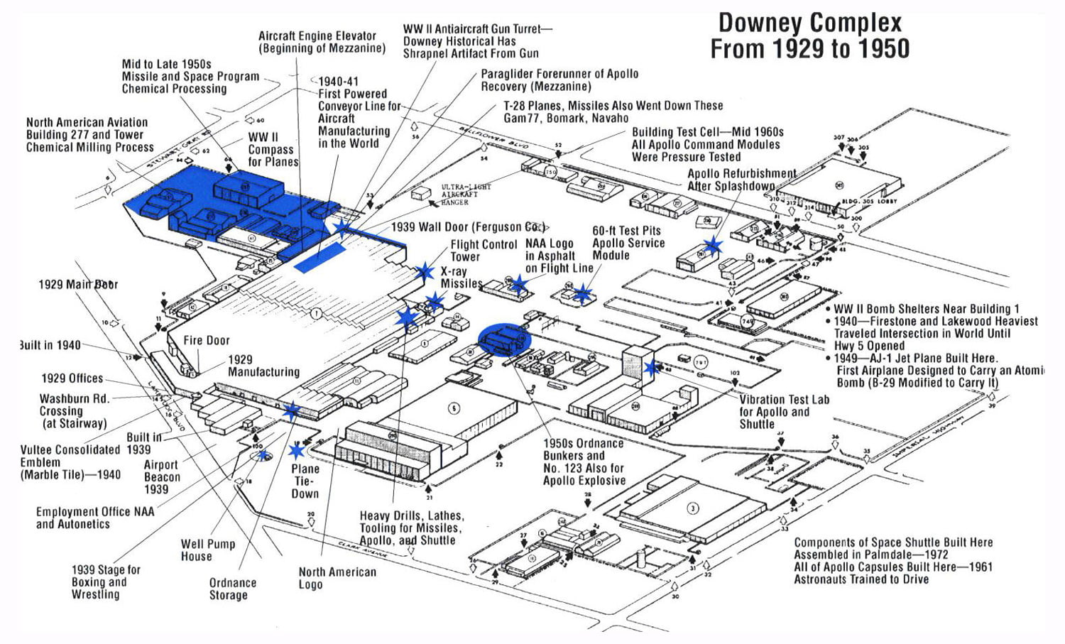
Credit: "RESIGHT" website
“NASA Apollo Spacecraft — Re-entry
Space and Information Systems Division
North American Aviation, Inc.”
Above per the larger presentation/portfolio print version of the image & linked to below.
One of Gary Meyers’ earliest NAA/NASA works, as part of an illustrious & diverse career.
garymeyerillustration.net/ILLUSTRATIONS/Pages/early_work....
Credit: GARY MEYER ILLUSTRATION website
Rest In Peace Mr. Meyer, THANK YOU.
(further information and pictures you can get by clicking on the link at the end of page!)
Mariahilferstraße
Mariahilferstraße, 6th, 7th, 14th and 15th, since 1897 (in the 6th and 7th district originally Kremser Sraße, then Bavarian highway, Laimgrubner main road, Mariahilfer main street, Fünfhauserstraße, Schönbrunnerstraße and Penzinger Poststraße, then Schönbrunner Straße), in memory of the old suburb name; Mariahilf was an independent municipality from 1660 to 1850, since then with Gumpendorf, Magdalenengrund, Windmühle and Laimgrube 6th District.
From
aeiou - the cultural information system of the bm: bwk
14,000 key words and 2000 pictures from history, geography, politics and business in Austria
Mariahilferstraße, 1908 - Wien Museum
Mariahilferstraße, 1908
Picture taken from "August Stauda - A documentarian of old Vienna"
published by Christian Brandstätter - to Book Description
History
Pottery and wine
The first ones who demonstrably populated the area of today's Mariahilferstraße (after the mammoth) were the Illyrians. They took advantage of the rich clay deposits for making simple vessels. The Celts planted on the sunny hills the first grape vines and understood the wine-making process very well. When the Romans occupied at the beginning of our Era Vienna for several centuries, they left behind many traces. The wine culture of the Celts they refined. On the hill of today's Mariahilferstraße run a Roman ridge trail, whose origins lay in the camp of Vindobona. After the rule of the Romans, the migration of peoples temporarily led many cultures here until after the expulsion of the Avars Bavarian colonists came from the West.
The peasant Middle Ages - From the vineyard to the village
Thanks to the loamy soil formed the winery, which has been pushed back only until the development of the suburbs, until the mid-17th Century the livelihood of the rural population. "Im Schöff" but also "Schöpf - scoop" and "Schiff - ship" (from "draw of") the area at the time was called. The erroneous use of a ship in the seal of the district is reminiscent of the old name, which was then replaced by the picture of grace "Mariahilf". The Weinberg (vineyard) law imposed at that time that the ground rent in the form of mash on the spot had to be paid. This was referred to as a "draw".
1495 the Mariahilfer wine was added to the wine disciplinary regulations for Herrenweine (racy, hearty, fruity, pithy wine with pleasant acidity) because of its special quality and achieved high prices.
1529 The first Turkish siege
Mariahilferstraße, already than an important route to the West, was repeatedly the scene of historical encounters. When the Turks besieged Vienna for the first time, was at the lower end of today Mariahilferstrasse, just outside the city walls of Vienna, a small settlement of houses and cottages, gardens and fields. Even the St. Theobald Monastery was there. This so-called "gap" was burned at the approach of the Turks, for them not to offer hiding places at the siege. Despite a prohibition, the area was rebuilt after departure of the Turks.
1558, a provision was adopted so that the glacis, a broad, unobstructed strip between the city wall and the outer settlements, should be left free. The Glacis existed until the demolition of the city walls in 1858. Here the ring road was later built.
1663 The new Post Road
With the new purpose of the Mariahilferstrasse as post road the first three roadside inn houses were built. At the same time the travel increased, since the carriages were finally more comfortable and the roads safer. Two well-known expressions date from this period. The "tip" and "kickbacks". In the old travel handbooks of that time we encounter them as guards beside the route, the travel and baggage tariff. The tip should the driver at the rest stop pay for the drink, while the bribe was calculated in proportion to the axle grease. Who was in a hurry, just paid a higher lubricant (Schmiergeld) or tip to motivate the coachman.
1683 The second Turkish siege
The second Turkish siege brought Mariahilferstraße the same fate. Meanwhile, a considerable settlement was formed, a real suburb, which, however, still had a lot of fields and brick pits. Again, the suburb along the Mariahilferstraße was razed to the ground, the population sought refuge behind the walls or in the Vienna Woods. The reconstruction progressed slowly since there was a lack of funds and manpower. Only at the beginning of the 18th Century took place a targeted reconstruction.
1686 Palais Esterhazy
On several "Brandstetten", by the second Turkish siege destroyed houses, the Hungarian aristocratic family Esterhazy had built herself a simple palace, which also had a passage on the Mariahilferstrasse. 1764 bought the innkeeper Paul Winkelmayr from Spittelberg the building, demolished it and built two new buildings that have been named in accordance with the Esterhazy "to the Hungarian crown."
17th Century to 19th Century. Fom the village to suburb
With the development of the settlements on the Mariahilferstraße from village to suburbs, changed not only the appearance but also the population. More and more agricultural land fell victim to the development, craftsmen and tradesmen settled there. There was an incredible variety of professions and trades, most of which were organized into guilds or crafts. Those cared for vocational training, quality and price of the goods, and in cases of unemployment, sickness and death.
The farms were replaced by churches and palaces, houses and shops. Mariahilf changed into a major industrial district, Mariahilferstrasse was an important trading center. Countless street traders sold the goods, which they carried either with them, or put in a street stall on display. The dealers made themselves noticeable by a significant Kaufruf (purchase call). So there was the ink man who went about with his bottles, the Wasserbauer (hydraulic engineering) who sold Danube water on his horse-drawn vehicle as industrial water, or the lavender woman. This lovely Viennese figures disappeared with the emergence of fixed premises and the improvement of urban transport.
Private carriages, horse-drawn carriages and buggies populated the streets, who used this route also for trips. At Mariahilferplatz Linientor (gate) was the main stand of the cheapest and most popular means of transport, the Zeiselwagen, which the Wiener used for their excursions into nature, which gradually became fashionable. In the 19th Century then yet arrived the Stellwagen (carriage) and bus traffic which had to accomplish the connection between Vienna and the suburbs. As a Viennese joke has it, suggests the Stellwagen that it has been so called because it did not come from the spot.
1719 - 1723 Royal and Imperial Court Stables
Emperor Charles VI. gave the order for the construction of the stables to Johann Bernhard Fischer von Erlach. 1772 the building was extended by two houses on the Mariahilferstrasse. The size of the stables still shows, as it serves as the Museum Quarter - its former importance. The Mariahilferstraße since the building of Schönbrunn Palace by the Imperial court very strongly was frequented. Today in the historic buildings the Museum Quarter is housed.
The church and monastery of Maria Hülff
Coloured engraving by J. Ziegler, 1783
1730 Mariahilferkirche
1711 began the renovation works at the Mariahilferkirche, giving the church building today's appearance and importance as a baroque monument. The plans stem from Franziskus Jänkl, the foreman of Lukas von Hildebrandt. Originally stood on the site of the Mariahilferkirche in the medieval vineyard "In Schoeff" a cemetery with wooden chapel built by the Barnabites. Already in those days, the miraculous image Mariahilf was located therein. During the Ottoman siege the chapel was destroyed, the miraculous image could be saved behind the protective walls. After the provisional reconstruction the miraculous image in a triumphal procession was returned, accompanied by 30,000 Viennese.
1790 - 1836 Ferdinand Raimund
Although in the district Mariahilf many artists and historical figures of Vienna lived , it is noticeable that as a residence they rather shunned the Mariahilferstraße, because as early as in the 18th Century there was a very lively and loud bustle on the street. The most famous person who was born on the Mariahilferstrasse is the folk actor and dramatist Ferdinand Raimund. He came in the house No. 45, "To the Golden deer (Zum Goldenen Hirschen)", which still exists today, as son of a turner into the world. As confectioners apprentice, he also had to visit the theaters, where he was a so-called "Numero", who sold his wares to the visitors. This encounter with the theater was fateful. He took flight from his training masters and joined a traveling troupe as an actor. After his return to Vienna, he soon became the most popular comedian. In his plays all those figures appeared then bustling the streets of Vienna. His most famous role was that of the "ash man" in "Farmer as Millionaire", a genuine Viennese guy who brings the wood ash in Butte from the houses, and from the proceeds leading a modest existence.
1805 - 1809 French occupation
The two-time occupation of Vienna by the French hit the suburbs hard. But the buildings were not destroyed fortunately.
19th century Industrialization
Here, where a higher concentration of artisans had developed as in other districts, you could feel the competition of the factories particularly hard. A craftsman after another became factory worker, women and child labor was part of the day-to-day business. With the sharp rise of the population grew apartment misery and flourished bed lodgers and roomers business.
1826
The Mariahilferstraße is paved up to the present belt (Gürtel).
1848 years of the revolution
The Mariahilferstraße this year was in turmoil. At the outbreak of the revolution, the hatred of the people was directed against the Verzehrungssteuerämter (some kind of tax authority) at the lines that have been blamed for the rise of food prices, and against the machines in the factories that had made the small craftsmen out of work or dependent workers. In October, students, workers and citizens tore up paving stones and barricaded themselves in the Mariahilfer Linientor (the so-called Linienwall was the tax frontier) in the area of today's belt.
1858 The Ring Road
The city walls fell and on the glacis arose the ring-road, the now 6th District more closely linking to the city center.
1862 Official naming
The Mariahilferstraße received its to the present day valid name, after it previously was bearing the following unofficial names: "Bavarian country road", "Mariahilfer Grund Straße", "Penzinger Street", "Laimgrube main street" and "Schönbrunner Linienstraße".
The turn of the century: development to commercial street
After the revolution of 1848, the industry displaced the dominant small business rapidly. At the same time the Mariahilferstraße developed into the first major shopping street of Vienna. The rising supply had to be passed on to the customer, and so more and more new shops sprang up. Around the turn of the century broke out a real building boom. The low suburban houses with Baroque and Biedermeier facade gave way to multi-storey houses with flashy and ostentatious facades in that historic style mixture, which was so characteristic of the late Ringstrasse period. From the former historic buildings almost nothing remained. The business portals were bigger and more pompous, the first department stores in the modern style were Gerngross and Herzmansky. Especially the clothing industry took root here.
1863 Herzmansky opened
On 3 March opened August Herzmansky a small general store in the Church Lane (Kirchengasse) 4. 1897 the great establishment in the pin alley (Stiftgasse) was opened, the largest textile company of the monarchy. August Herzmansky died a year before the opening, two nephews take over the business. In 1928, Mariahilferstraße 28 is additionally acquired. 1938, the then owner Max Delfiner had to flee, the company Rhonberg and Hämmerle took over the house. The building in Mariahilferstrasse 30 additionally was purchased. In the last days of the war in 1945 it fell victim to the flames, however. 1948, the company was returned to Max Delfiner, whose son sold in 1957 to the German Hertie group, a new building in Mariahilferstrasse 26 - 30 constructing. Other ownership changes followed.
1869 The Pferdetramway
The Pferdetramway made it first trip through the Mariahilferstraße to Neubaugasse.
Opened in 1879 Gerngroß
Mariahilferstraße about 1905
Alfred Gerngross, a merchant from Bavaria and co-worker August
Herzmanskys, founded on Mariahilferstrasse 48/corner Church alley (Kirchengasse) an own fabric store. He became the fiercest competitor of his former boss.
1901 The k.k. Imperial Furniture Collection
The k.k. Hofmobilien and material depot is established in Mariahilferstrasse 88. The collection quickly grew because each new ruler got new furniture. Today, it serves as a museum. Among other things, there is the office of Emperor Franz Joseph, the equipment of Emperor Maximilian of Mexico from Miramare Castle, the splendid table of Charles VI. and the furniture from the Oriental Cabinet of Crown Prince Rudolf.
1911 The House Stafa
On 18 August 1911, on the birthday of Emperor Franz Joseph, corner Mariahilferstraße/imperial road (Kaiserstraße) the "central palace" was opened. The construction by its architecture created a sensation. Nine large double figure-relief panels of Anton Hanak decorated it. In this building the "1st Vienna Commercial sample collective department store (Warenmuster-Kollektivkaufhaus)", a eight-storey circular building was located, which was to serve primarily the craft. The greatest adversity in the construction were underground springs. Two dug wells had to be built to pump out the water. 970 liters per minute, however, must be pumped out until today.
1945 bombing of Vienna
On 21 February 1945 bombs fell on the Mariahilferstrasse, many buildings were badly damaged. On 10th April Wiener looted the store Herzmansky. Ella Fasser, the owner of the café "Goethe" in Mariahilferstrasse, preserved the Monastery barracks (Stiftskaserne) from destruction, with the help other resistance fighters cutting the fire-conducting cords that had laid the retreating German troops. Meanwhile, she invited the officers to the cafe, and befuddled them with plenty of alcohol.
(further information and pictures you can get by clicking on the link at the end of page!)
Mariahilferstraße
Mariahilferstraße, 6th, 7th, 14th and 15th, since 1897 (in the 6th and 7th district originally Kremser Sraße, then Bavarian highway, Laimgrubner main road, Mariahilfer main street, Fünfhauserstraße, Schönbrunnerstraße and Penzinger Poststraße, then Schönbrunner Straße), in memory of the old suburb name; Mariahilf was an independent municipality from 1660 to 1850, since then with Gumpendorf, Magdalenengrund, Windmühle and Laimgrube 6th District.
From
aeiou - the cultural information system of the bm: bwk
14,000 key words and 2000 pictures from history, geography, politics and business in Austria
Mariahilferstraße, 1908 - Wien Museum
Mariahilferstraße, 1908
Picture taken from "August Stauda - A documentarian of old Vienna"
published by Christian Brandstätter - to Book Description
History
Pottery and wine
The first ones who demonstrably populated the area of today's Mariahilferstraße (after the mammoth) were the Illyrians. They took advantage of the rich clay deposits for making simple vessels. The Celts planted on the sunny hills the first grape vines and understood the wine-making process very well. When the Romans occupied at the beginning of our Era Vienna for several centuries, they left behind many traces. The wine culture of the Celts they refined. On the hill of today's Mariahilferstraße run a Roman ridge trail, whose origins lay in the camp of Vindobona. After the rule of the Romans, the migration of peoples temporarily led many cultures here until after the expulsion of the Avars Bavarian colonists came from the West.
The peasant Middle Ages - From the vineyard to the village
Thanks to the loamy soil formed the winery, which has been pushed back only until the development of the suburbs, until the mid-17th Century the livelihood of the rural population. "Im Schöff" but also "Schöpf - scoop" and "Schiff - ship" (from "draw of") the area at the time was called. The erroneous use of a ship in the seal of the district is reminiscent of the old name, which was then replaced by the picture of grace "Mariahilf". The Weinberg (vineyard) law imposed at that time that the ground rent in the form of mash on the spot had to be paid. This was referred to as a "draw".
1495 the Mariahilfer wine was added to the wine disciplinary regulations for Herrenweine (racy, hearty, fruity, pithy wine with pleasant acidity) because of its special quality and achieved high prices.
1529 The first Turkish siege
Mariahilferstraße, already than an important route to the West, was repeatedly the scene of historical encounters. When the Turks besieged Vienna for the first time, was at the lower end of today Mariahilferstrasse, just outside the city walls of Vienna, a small settlement of houses and cottages, gardens and fields. Even the St. Theobald Monastery was there. This so-called "gap" was burned at the approach of the Turks, for them not to offer hiding places at the siege. Despite a prohibition, the area was rebuilt after departure of the Turks.
1558, a provision was adopted so that the glacis, a broad, unobstructed strip between the city wall and the outer settlements, should be left free. The Glacis existed until the demolition of the city walls in 1858. Here the ring road was later built.
1663 The new Post Road
With the new purpose of the Mariahilferstrasse as post road the first three roadside inn houses were built. At the same time the travel increased, since the carriages were finally more comfortable and the roads safer. Two well-known expressions date from this period. The "tip" and "kickbacks". In the old travel handbooks of that time we encounter them as guards beside the route, the travel and baggage tariff. The tip should the driver at the rest stop pay for the drink, while the bribe was calculated in proportion to the axle grease. Who was in a hurry, just paid a higher lubricant (Schmiergeld) or tip to motivate the coachman.
1683 The second Turkish siege
The second Turkish siege brought Mariahilferstraße the same fate. Meanwhile, a considerable settlement was formed, a real suburb, which, however, still had a lot of fields and brick pits. Again, the suburb along the Mariahilferstraße was razed to the ground, the population sought refuge behind the walls or in the Vienna Woods. The reconstruction progressed slowly since there was a lack of funds and manpower. Only at the beginning of the 18th Century took place a targeted reconstruction.
1686 Palais Esterhazy
On several "Brandstetten", by the second Turkish siege destroyed houses, the Hungarian aristocratic family Esterhazy had built herself a simple palace, which also had a passage on the Mariahilferstrasse. 1764 bought the innkeeper Paul Winkelmayr from Spittelberg the building, demolished it and built two new buildings that have been named in accordance with the Esterhazy "to the Hungarian crown."
17th Century to 19th Century. Fom the village to suburb
With the development of the settlements on the Mariahilferstraße from village to suburbs, changed not only the appearance but also the population. More and more agricultural land fell victim to the development, craftsmen and tradesmen settled there. There was an incredible variety of professions and trades, most of which were organized into guilds or crafts. Those cared for vocational training, quality and price of the goods, and in cases of unemployment, sickness and death.
The farms were replaced by churches and palaces, houses and shops. Mariahilf changed into a major industrial district, Mariahilferstrasse was an important trading center. Countless street traders sold the goods, which they carried either with them, or put in a street stall on display. The dealers made themselves noticeable by a significant Kaufruf (purchase call). So there was the ink man who went about with his bottles, the Wasserbauer (hydraulic engineering) who sold Danube water on his horse-drawn vehicle as industrial water, or the lavender woman. This lovely Viennese figures disappeared with the emergence of fixed premises and the improvement of urban transport.
Private carriages, horse-drawn carriages and buggies populated the streets, who used this route also for trips. At Mariahilferplatz Linientor (gate) was the main stand of the cheapest and most popular means of transport, the Zeiselwagen, which the Wiener used for their excursions into nature, which gradually became fashionable. In the 19th Century then yet arrived the Stellwagen (carriage) and bus traffic which had to accomplish the connection between Vienna and the suburbs. As a Viennese joke has it, suggests the Stellwagen that it has been so called because it did not come from the spot.
1719 - 1723 Royal and Imperial Court Stables
Emperor Charles VI. gave the order for the construction of the stables to Johann Bernhard Fischer von Erlach. 1772 the building was extended by two houses on the Mariahilferstrasse. The size of the stables still shows, as it serves as the Museum Quarter - its former importance. The Mariahilferstraße since the building of Schönbrunn Palace by the Imperial court very strongly was frequented. Today in the historic buildings the Museum Quarter is housed.
The church and monastery of Maria Hülff
Coloured engraving by J. Ziegler, 1783
1730 Mariahilferkirche
1711 began the renovation works at the Mariahilferkirche, giving the church building today's appearance and importance as a baroque monument. The plans stem from Franziskus Jänkl, the foreman of Lukas von Hildebrandt. Originally stood on the site of the Mariahilferkirche in the medieval vineyard "In Schoeff" a cemetery with wooden chapel built by the Barnabites. Already in those days, the miraculous image Mariahilf was located therein. During the Ottoman siege the chapel was destroyed, the miraculous image could be saved behind the protective walls. After the provisional reconstruction the miraculous image in a triumphal procession was returned, accompanied by 30,000 Viennese.
1790 - 1836 Ferdinand Raimund
Although in the district Mariahilf many artists and historical figures of Vienna lived , it is noticeable that as a residence they rather shunned the Mariahilferstraße, because as early as in the 18th Century there was a very lively and loud bustle on the street. The most famous person who was born on the Mariahilferstrasse is the folk actor and dramatist Ferdinand Raimund. He came in the house No. 45, "To the Golden deer (Zum Goldenen Hirschen)", which still exists today, as son of a turner into the world. As confectioners apprentice, he also had to visit the theaters, where he was a so-called "Numero", who sold his wares to the visitors. This encounter with the theater was fateful. He took flight from his training masters and joined a traveling troupe as an actor. After his return to Vienna, he soon became the most popular comedian. In his plays all those figures appeared then bustling the streets of Vienna. His most famous role was that of the "ash man" in "Farmer as Millionaire", a genuine Viennese guy who brings the wood ash in Butte from the houses, and from the proceeds leading a modest existence.
1805 - 1809 French occupation
The two-time occupation of Vienna by the French hit the suburbs hard. But the buildings were not destroyed fortunately.
19th century Industrialization
Here, where a higher concentration of artisans had developed as in other districts, you could feel the competition of the factories particularly hard. A craftsman after another became factory worker, women and child labor was part of the day-to-day business. With the sharp rise of the population grew apartment misery and flourished bed lodgers and roomers business.
1826
The Mariahilferstraße is paved up to the present belt (Gürtel).
1848 years of the revolution
The Mariahilferstraße this year was in turmoil. At the outbreak of the revolution, the hatred of the people was directed against the Verzehrungssteuerämter (some kind of tax authority) at the lines that have been blamed for the rise of food prices, and against the machines in the factories that had made the small craftsmen out of work or dependent workers. In October, students, workers and citizens tore up paving stones and barricaded themselves in the Mariahilfer Linientor (the so-called Linienwall was the tax frontier) in the area of today's belt.
1858 The Ring Road
The city walls fell and on the glacis arose the ring-road, the now 6th District more closely linking to the city center.
1862 Official naming
The Mariahilferstraße received its to the present day valid name, after it previously was bearing the following unofficial names: "Bavarian country road", "Mariahilfer Grund Straße", "Penzinger Street", "Laimgrube main street" and "Schönbrunner Linienstraße".
The turn of the century: development to commercial street
After the revolution of 1848, the industry displaced the dominant small business rapidly. At the same time the Mariahilferstraße developed into the first major shopping street of Vienna. The rising supply had to be passed on to the customer, and so more and more new shops sprang up. Around the turn of the century broke out a real building boom. The low suburban houses with Baroque and Biedermeier facade gave way to multi-storey houses with flashy and ostentatious facades in that historic style mixture, which was so characteristic of the late Ringstrasse period. From the former historic buildings almost nothing remained. The business portals were bigger and more pompous, the first department stores in the modern style were Gerngross and Herzmansky. Especially the clothing industry took root here.
1863 Herzmansky opened
On 3 March opened August Herzmansky a small general store in the Church Lane (Kirchengasse) 4. 1897 the great establishment in the pin alley (Stiftgasse) was opened, the largest textile company of the monarchy. August Herzmansky died a year before the opening, two nephews take over the business. In 1928, Mariahilferstraße 28 is additionally acquired. 1938, the then owner Max Delfiner had to flee, the company Rhonberg and Hämmerle took over the house. The building in Mariahilferstrasse 30 additionally was purchased. In the last days of the war in 1945 it fell victim to the flames, however. 1948, the company was returned to Max Delfiner, whose son sold in 1957 to the German Hertie group, a new building in Mariahilferstrasse 26 - 30 constructing. Other ownership changes followed.
1869 The Pferdetramway
The Pferdetramway made it first trip through the Mariahilferstraße to Neubaugasse.
Opened in 1879 Gerngroß
Mariahilferstraße about 1905
Alfred Gerngross, a merchant from Bavaria and co-worker August
Herzmanskys, founded on Mariahilferstrasse 48/corner Church alley (Kirchengasse) an own fabric store. He became the fiercest competitor of his former boss.
1901 The k.k. Imperial Furniture Collection
The k.k. Hofmobilien and material depot is established in Mariahilferstrasse 88. The collection quickly grew because each new ruler got new furniture. Today, it serves as a museum. Among other things, there is the office of Emperor Franz Joseph, the equipment of Emperor Maximilian of Mexico from Miramare Castle, the splendid table of Charles VI. and the furniture from the Oriental Cabinet of Crown Prince Rudolf.
1911 The House Stafa
On 18 August 1911, on the birthday of Emperor Franz Joseph, corner Mariahilferstraße/imperial road (Kaiserstraße) the "central palace" was opened. The construction by its architecture created a sensation. Nine large double figure-relief panels of Anton Hanak decorated it. In this building the "1st Vienna Commercial sample collective department store (Warenmuster-Kollektivkaufhaus)", a eight-storey circular building was located, which was to serve primarily the craft. The greatest adversity in the construction were underground springs. Two dug wells had to be built to pump out the water. 970 liters per minute, however, must be pumped out until today.
1945 bombing of Vienna
On 21 February 1945 bombs fell on the Mariahilferstrasse, many buildings were badly damaged. On 10th April Wiener looted the store Herzmansky. Ella Fasser, the owner of the café "Goethe" in Mariahilferstrasse, preserved the Monastery barracks (Stiftskaserne) from destruction, with the help other resistance fighters cutting the fire-conducting cords that had laid the retreating German troops. Meanwhile, she invited the officers to the cafe, and befuddled them with plenty of alcohol.
[polski opis warty przeczytania niżej]
Railbus SA101/121-003 as the regional passenger train no. 7729 from Tczew to Chojnice, enters Czarna Woda station. August 10, 2013.
It was only a few months after the overhaul of the vehicle, as turned out - the last one. At the beginning of 2016, the vehicle's certificate of technical ability terminated, and only a year later it was simply scrapped. This was the fate of the vast majority of the 207M series, i.e. the first Polish model of real light railbuses, which included motor, and trailer cars (middle and terminal), and the combined vehicles were marked SA101/121 (two-unit: engine - trailer) and SA102/111 (three-unit: engine - trailer - engine). It is worth mentioning here that the designer of these vehicles was Ryszard Suwalski, known primarily from the SUW2000 system for automatic transition of the wheelbase of vehicles between 1435 and 1520 mm (standard and broad gauge). The production of the railbuses took place in ZNTK Poznań.
Six railbuses of both series (3 units of each type) were manufactured in 1991-1996 and in the initial period serviced secondary lines in the Pomeranian and Dolnośląskie voivodeships (in the latter, only one railbus SA102/111-001), but the last years of operation in the first years of 2010ies is only Pomerania. According to Wikipedia, on July 8, 2017, the last run of the railbus 207M took place, and it was an extraordinary train for railfans on the route Chojnice - Świecie Przechowo - Chojnice, organized by the Chojnice Association of Railway Enthusiasts (Chojnickie Stowarzyszenie Miłośników Kolei), and the last vehicle running was SA102/111-002. Currently, three vehicles have been scrapped to date (SA101/121-002, SA101/121-003 and SA102/111-001), two are withdrawn from the service (SA101/121-001 and SA102/111-003) and one has been transferred to the Railway Museum in Silesia (Jaworzyna Śląska) to be preserved as an exhibit.
After a quarter of a century, the first Polish light railbuses went down in history without much emotion. They were just replaced by more modern classes, meeting current requirements (access for the disabled, places for bicycles, more space for passengers, information systems, air conditioning, etc.). And although no line of Polish railbuses originates directly from the 207M class, it is worth remembering this episode from the first years after the collapse of communism.
Photo by Jarek / Chester
Szynobus SA101/121-003 jako pociąg osobowy nr 7729 z Tczewa do Chojnic, wjeżdża do stacji Czarna Woda. 10 sierpnia 2013 roku.
Wówczas było to kilka miesięcy po naprawie rewizyjnej pojazdu, jak historia pokazała - ostatniej. Na początku 2016 roku skończyło się pojazdowi świadectwo sprawności technicznej, a rok później został złomowany. Taki los spotkał znakomitą większość serii 207M, czyli pierwszej polskiej serii prawdziwych lekkich szynobusów, która obejmowała wagony silnikowe, rozrządcze oraz doczepne, a skombinowane z nich pojazdy nosiły oznaczenia SA101/121 (dwuczłonowy: silnikowy - rozrządczy) oraz SA102/111 (trzyczłonowy: silnikowy - doczepny - silnikowy). Warto tu wspomnieć, iż konstruktorem tych pojazdów był Ryszard Suwalski, znany przede wszystkim z systemu SUW2000 do przestawiania rozstawu zestawów kołowych pojazdów na szerokości 1435/1520 m, a produkcja była realizowana w ZNTK Poznań.
6 szynobusów obu serii (po 3 sztuki każdego typu) zostało wyprodukowanych w latach 1991-1996 i w początkowym okresie obsługiwały mniej obciążone linie w województwie pomorskim oraz dolnośląskim (tam tylko jeden szynobus SA102/111-001), ale ostatnie lata eksploatacji w pierwszej połowie drugiej dekady XXI wieku to już wyłącznie Pomorze. Według Wikipedii, 8 lipca 2017 roku odbył się ostatni kurs szynobusu 207M, a był to przejazd specjalny relacji Chojnice - Świecie Przechowo - Chojnice, zorganizowany przez Chojnickie Stowarzyszenie Miłośników Kolei, a tym ostatnim pojazdem w ruchu był SA102/111-002. Aktualnie trzy pojazdy zostały do dziś zezłomowane (SA101/121-002, SA101/121-003 oraz SA102/111-001), dwa są odstawione jako nieczynne (SA101/121-001 oraz SA102/111-003), a jeden został przekazany do Muzeum Kolejnictwa na Śląsku z przeznaczeniem do zachowania jako eksponat.
Pierwsze polskie lekkie szynobusy po ćwierćwieczu odeszły bez większych emocji do historii. Zastąpiły je konstrukcje nowocześniejsze, dostosowane do aktualnych wymagań (dostęp dla niepełnosprawnych, miejsca dla rowerów, większa przestrzeń dla pasażerów, systemy informacji, klimatyzacja). I chociaż bezpośrednio z 207M nie wywodzi się żadna linia polskich szynobusów, to warto pamiętać o tym epizodzie z okresu przełomu ustroju.
Fot. Jarek / Chester
(further information and pictures you can get by clicking on the link at the end of page!)
Mariahilferstraße
Mariahilferstraße, 6th, 7th, 14th and 15th, since 1897 (in the 6th and 7th district originally Kremser Sraße, then Bavarian highway, Laimgrubner main road, Mariahilfer main street, Fünfhauserstraße, Schönbrunnerstraße and Penzinger Poststraße, then Schönbrunner Straße), in memory of the old suburb name; Mariahilf was an independent municipality from 1660 to 1850, since then with Gumpendorf, Magdalenengrund, Windmühle and Laimgrube 6th District.
From
aeiou - the cultural information system of the bm: bwk
14,000 key words and 2000 pictures from history, geography, politics and business in Austria
Mariahilferstraße, 1908 - Wien Museum
Mariahilferstraße, 1908
Picture taken from "August Stauda - A documentarian of old Vienna"
published by Christian Brandstätter - to Book Description
History
Pottery and wine
The first ones who demonstrably populated the area of today's Mariahilferstraße (after the mammoth) were the Illyrians. They took advantage of the rich clay deposits for making simple vessels. The Celts planted on the sunny hills the first grape vines and understood the wine-making process very well. When the Romans occupied at the beginning of our Era Vienna for several centuries, they left behind many traces. The wine culture of the Celts they refined. On the hill of today's Mariahilferstraße run a Roman ridge trail, whose origins lay in the camp of Vindobona. After the rule of the Romans, the migration of peoples temporarily led many cultures here until after the expulsion of the Avars Bavarian colonists came from the West.
The peasant Middle Ages - From the vineyard to the village
Thanks to the loamy soil formed the winery, which has been pushed back only until the development of the suburbs, until the mid-17th Century the livelihood of the rural population. "Im Schöff" but also "Schöpf - scoop" and "Schiff - ship" (from "draw of") the area at the time was called. The erroneous use of a ship in the seal of the district is reminiscent of the old name, which was then replaced by the picture of grace "Mariahilf". The Weinberg (vineyard) law imposed at that time that the ground rent in the form of mash on the spot had to be paid. This was referred to as a "draw".
1495 the Mariahilfer wine was added to the wine disciplinary regulations for Herrenweine (racy, hearty, fruity, pithy wine with pleasant acidity) because of its special quality and achieved high prices.
1529 The first Turkish siege
Mariahilferstraße, already than an important route to the West, was repeatedly the scene of historical encounters. When the Turks besieged Vienna for the first time, was at the lower end of today Mariahilferstrasse, just outside the city walls of Vienna, a small settlement of houses and cottages, gardens and fields. Even the St. Theobald Monastery was there. This so-called "gap" was burned at the approach of the Turks, for them not to offer hiding places at the siege. Despite a prohibition, the area was rebuilt after departure of the Turks.
1558, a provision was adopted so that the glacis, a broad, unobstructed strip between the city wall and the outer settlements, should be left free. The Glacis existed until the demolition of the city walls in 1858. Here the ring road was later built.
1663 The new Post Road
With the new purpose of the Mariahilferstrasse as post road the first three roadside inn houses were built. At the same time the travel increased, since the carriages were finally more comfortable and the roads safer. Two well-known expressions date from this period. The "tip" and "kickbacks". In the old travel handbooks of that time we encounter them as guards beside the route, the travel and baggage tariff. The tip should the driver at the rest stop pay for the drink, while the bribe was calculated in proportion to the axle grease. Who was in a hurry, just paid a higher lubricant (Schmiergeld) or tip to motivate the coachman.
1683 The second Turkish siege
The second Turkish siege brought Mariahilferstraße the same fate. Meanwhile, a considerable settlement was formed, a real suburb, which, however, still had a lot of fields and brick pits. Again, the suburb along the Mariahilferstraße was razed to the ground, the population sought refuge behind the walls or in the Vienna Woods. The reconstruction progressed slowly since there was a lack of funds and manpower. Only at the beginning of the 18th Century took place a targeted reconstruction.
1686 Palais Esterhazy
On several "Brandstetten", by the second Turkish siege destroyed houses, the Hungarian aristocratic family Esterhazy had built herself a simple palace, which also had a passage on the Mariahilferstrasse. 1764 bought the innkeeper Paul Winkelmayr from Spittelberg the building, demolished it and built two new buildings that have been named in accordance with the Esterhazy "to the Hungarian crown."
17th Century to 19th Century. Fom the village to suburb
With the development of the settlements on the Mariahilferstraße from village to suburbs, changed not only the appearance but also the population. More and more agricultural land fell victim to the development, craftsmen and tradesmen settled there. There was an incredible variety of professions and trades, most of which were organized into guilds or crafts. Those cared for vocational training, quality and price of the goods, and in cases of unemployment, sickness and death.
The farms were replaced by churches and palaces, houses and shops. Mariahilf changed into a major industrial district, Mariahilferstrasse was an important trading center. Countless street traders sold the goods, which they carried either with them, or put in a street stall on display. The dealers made themselves noticeable by a significant Kaufruf (purchase call). So there was the ink man who went about with his bottles, the Wasserbauer (hydraulic engineering) who sold Danube water on his horse-drawn vehicle as industrial water, or the lavender woman. This lovely Viennese figures disappeared with the emergence of fixed premises and the improvement of urban transport.
Private carriages, horse-drawn carriages and buggies populated the streets, who used this route also for trips. At Mariahilferplatz Linientor (gate) was the main stand of the cheapest and most popular means of transport, the Zeiselwagen, which the Wiener used for their excursions into nature, which gradually became fashionable. In the 19th Century then yet arrived the Stellwagen (carriage) and bus traffic which had to accomplish the connection between Vienna and the suburbs. As a Viennese joke has it, suggests the Stellwagen that it has been so called because it did not come from the spot.
1719 - 1723 Royal and Imperial Court Stables
Emperor Charles VI. gave the order for the construction of the stables to Johann Bernhard Fischer von Erlach. 1772 the building was extended by two houses on the Mariahilferstrasse. The size of the stables still shows, as it serves as the Museum Quarter - its former importance. The Mariahilferstraße since the building of Schönbrunn Palace by the Imperial court very strongly was frequented. Today in the historic buildings the Museum Quarter is housed.
The church and monastery of Maria Hülff
Coloured engraving by J. Ziegler, 1783
1730 Mariahilferkirche
1711 began the renovation works at the Mariahilferkirche, giving the church building today's appearance and importance as a baroque monument. The plans stem from Franziskus Jänkl, the foreman of Lukas von Hildebrandt. Originally stood on the site of the Mariahilferkirche in the medieval vineyard "In Schoeff" a cemetery with wooden chapel built by the Barnabites. Already in those days, the miraculous image Mariahilf was located therein. During the Ottoman siege the chapel was destroyed, the miraculous image could be saved behind the protective walls. After the provisional reconstruction the miraculous image in a triumphal procession was returned, accompanied by 30,000 Viennese.
1790 - 1836 Ferdinand Raimund
Although in the district Mariahilf many artists and historical figures of Vienna lived , it is noticeable that as a residence they rather shunned the Mariahilferstraße, because as early as in the 18th Century there was a very lively and loud bustle on the street. The most famous person who was born on the Mariahilferstrasse is the folk actor and dramatist Ferdinand Raimund. He came in the house No. 45, "To the Golden deer (Zum Goldenen Hirschen)", which still exists today, as son of a turner into the world. As confectioners apprentice, he also had to visit the theaters, where he was a so-called "Numero", who sold his wares to the visitors. This encounter with the theater was fateful. He took flight from his training masters and joined a traveling troupe as an actor. After his return to Vienna, he soon became the most popular comedian. In his plays all those figures appeared then bustling the streets of Vienna. His most famous role was that of the "ash man" in "Farmer as Millionaire", a genuine Viennese guy who brings the wood ash in Butte from the houses, and from the proceeds leading a modest existence.
1805 - 1809 French occupation
The two-time occupation of Vienna by the French hit the suburbs hard. But the buildings were not destroyed fortunately.
19th century Industrialization
Here, where a higher concentration of artisans had developed as in other districts, you could feel the competition of the factories particularly hard. A craftsman after another became factory worker, women and child labor was part of the day-to-day business. With the sharp rise of the population grew apartment misery and flourished bed lodgers and roomers business.
1826
The Mariahilferstraße is paved up to the present belt (Gürtel).
1848 years of the revolution
The Mariahilferstraße this year was in turmoil. At the outbreak of the revolution, the hatred of the people was directed against the Verzehrungssteuerämter (some kind of tax authority) at the lines that have been blamed for the rise of food prices, and against the machines in the factories that had made the small craftsmen out of work or dependent workers. In October, students, workers and citizens tore up paving stones and barricaded themselves in the Mariahilfer Linientor (the so-called Linienwall was the tax frontier) in the area of today's belt.
1858 The Ring Road
The city walls fell and on the glacis arose the ring-road, the now 6th District more closely linking to the city center.
1862 Official naming
The Mariahilferstraße received its to the present day valid name, after it previously was bearing the following unofficial names: "Bavarian country road", "Mariahilfer Grund Straße", "Penzinger Street", "Laimgrube main street" and "Schönbrunner Linienstraße".
The turn of the century: development to commercial street
After the revolution of 1848, the industry displaced the dominant small business rapidly. At the same time the Mariahilferstraße developed into the first major shopping street of Vienna. The rising supply had to be passed on to the customer, and so more and more new shops sprang up. Around the turn of the century broke out a real building boom. The low suburban houses with Baroque and Biedermeier facade gave way to multi-storey houses with flashy and ostentatious facades in that historic style mixture, which was so characteristic of the late Ringstrasse period. From the former historic buildings almost nothing remained. The business portals were bigger and more pompous, the first department stores in the modern style were Gerngross and Herzmansky. Especially the clothing industry took root here.
1863 Herzmansky opened
On 3 March opened August Herzmansky a small general store in the Church Lane (Kirchengasse) 4. 1897 the great establishment in the pin alley (Stiftgasse) was opened, the largest textile company of the monarchy. August Herzmansky died a year before the opening, two nephews take over the business. In 1928, Mariahilferstraße 28 is additionally acquired. 1938, the then owner Max Delfiner had to flee, the company Rhonberg and Hämmerle took over the house. The building in Mariahilferstrasse 30 additionally was purchased. In the last days of the war in 1945 it fell victim to the flames, however. 1948, the company was returned to Max Delfiner, whose son sold in 1957 to the German Hertie group, a new building in Mariahilferstrasse 26 - 30 constructing. Other ownership changes followed.
1869 The Pferdetramway
The Pferdetramway made it first trip through the Mariahilferstraße to Neubaugasse.
Opened in 1879 Gerngroß
Mariahilferstraße about 1905
Alfred Gerngross, a merchant from Bavaria and co-worker August
Herzmanskys, founded on Mariahilferstrasse 48/corner Church alley (Kirchengasse) an own fabric store. He became the fiercest competitor of his former boss.
1901 The k.k. Imperial Furniture Collection
The k.k. Hofmobilien and material depot is established in Mariahilferstrasse 88. The collection quickly grew because each new ruler got new furniture. Today, it serves as a museum. Among other things, there is the office of Emperor Franz Joseph, the equipment of Emperor Maximilian of Mexico from Miramare Castle, the splendid table of Charles VI. and the furniture from the Oriental Cabinet of Crown Prince Rudolf.
1911 The House Stafa
On 18 August 1911, on the birthday of Emperor Franz Joseph, corner Mariahilferstraße/imperial road (Kaiserstraße) the "central palace" was opened. The construction by its architecture created a sensation. Nine large double figure-relief panels of Anton Hanak decorated it. In this building the "1st Vienna Commercial sample collective department store (Warenmuster-Kollektivkaufhaus)", a eight-storey circular building was located, which was to serve primarily the craft. The greatest adversity in the construction were underground springs. Two dug wells had to be built to pump out the water. 970 liters per minute, however, must be pumped out until today.
1945 bombing of Vienna
On 21 February 1945 bombs fell on the Mariahilferstrasse, many buildings were badly damaged. On 10th April Wiener looted the store Herzmansky. Ella Fasser, the owner of the café "Goethe" in Mariahilferstrasse, preserved the Monastery barracks (Stiftskaserne) from destruction, with the help other resistance fighters cutting the fire-conducting cords that had laid the retreating German troops. Meanwhile, she invited the officers to the cafe, and befuddled them with plenty of alcohol.
(further information and pictures you can get by clicking on the link at the end of page!)
Mariahilferstraße
Mariahilferstraße, 6th, 7th, 14th and 15th, since 1897 (in the 6th and 7th district originally Kremser Sraße, then Bavarian highway, Laimgrubner main road, Mariahilfer main street, Fünfhauserstraße, Schönbrunnerstraße and Penzinger Poststraße, then Schönbrunner Straße), in memory of the old suburb name; Mariahilf was an independent municipality from 1660 to 1850, since then with Gumpendorf, Magdalenengrund, Windmühle and Laimgrube 6th District.
From
aeiou - the cultural information system of the bm: bwk
14,000 key words and 2000 pictures from history, geography, politics and business in Austria
Mariahilferstraße, 1908 - Wien Museum
Mariahilferstraße, 1908
Picture taken from "August Stauda - A documentarian of old Vienna"
published by Christian Brandstätter - to Book Description
History
Pottery and wine
The first ones who demonstrably populated the area of today's Mariahilferstraße (after the mammoth) were the Illyrians. They took advantage of the rich clay deposits for making simple vessels. The Celts planted on the sunny hills the first grape vines and understood the wine-making process very well. When the Romans occupied at the beginning of our Era Vienna for several centuries, they left behind many traces. The wine culture of the Celts they refined. On the hill of today's Mariahilferstraße run a Roman ridge trail, whose origins lay in the camp of Vindobona. After the rule of the Romans, the migration of peoples temporarily led many cultures here until after the expulsion of the Avars Bavarian colonists came from the West.
The peasant Middle Ages - From the vineyard to the village
Thanks to the loamy soil formed the winery, which has been pushed back only until the development of the suburbs, until the mid-17th Century the livelihood of the rural population. "Im Schöff" but also "Schöpf - scoop" and "Schiff - ship" (from "draw of") the area at the time was called. The erroneous use of a ship in the seal of the district is reminiscent of the old name, which was then replaced by the picture of grace "Mariahilf". The Weinberg (vineyard) law imposed at that time that the ground rent in the form of mash on the spot had to be paid. This was referred to as a "draw".
1495 the Mariahilfer wine was added to the wine disciplinary regulations for Herrenweine (racy, hearty, fruity, pithy wine with pleasant acidity) because of its special quality and achieved high prices.
1529 The first Turkish siege
Mariahilferstraße, already than an important route to the West, was repeatedly the scene of historical encounters. When the Turks besieged Vienna for the first time, was at the lower end of today Mariahilferstrasse, just outside the city walls of Vienna, a small settlement of houses and cottages, gardens and fields. Even the St. Theobald Monastery was there. This so-called "gap" was burned at the approach of the Turks, for them not to offer hiding places at the siege. Despite a prohibition, the area was rebuilt after departure of the Turks.
1558, a provision was adopted so that the glacis, a broad, unobstructed strip between the city wall and the outer settlements, should be left free. The Glacis existed until the demolition of the city walls in 1858. Here the ring road was later built.
1663 The new Post Road
With the new purpose of the Mariahilferstrasse as post road the first three roadside inn houses were built. At the same time the travel increased, since the carriages were finally more comfortable and the roads safer. Two well-known expressions date from this period. The "tip" and "kickbacks". In the old travel handbooks of that time we encounter them as guards beside the route, the travel and baggage tariff. The tip should the driver at the rest stop pay for the drink, while the bribe was calculated in proportion to the axle grease. Who was in a hurry, just paid a higher lubricant (Schmiergeld) or tip to motivate the coachman.
1683 The second Turkish siege
The second Turkish siege brought Mariahilferstraße the same fate. Meanwhile, a considerable settlement was formed, a real suburb, which, however, still had a lot of fields and brick pits. Again, the suburb along the Mariahilferstraße was razed to the ground, the population sought refuge behind the walls or in the Vienna Woods. The reconstruction progressed slowly since there was a lack of funds and manpower. Only at the beginning of the 18th Century took place a targeted reconstruction.
1686 Palais Esterhazy
On several "Brandstetten", by the second Turkish siege destroyed houses, the Hungarian aristocratic family Esterhazy had built herself a simple palace, which also had a passage on the Mariahilferstrasse. 1764 bought the innkeeper Paul Winkelmayr from Spittelberg the building, demolished it and built two new buildings that have been named in accordance with the Esterhazy "to the Hungarian crown."
17th Century to 19th Century. Fom the village to suburb
With the development of the settlements on the Mariahilferstraße from village to suburbs, changed not only the appearance but also the population. More and more agricultural land fell victim to the development, craftsmen and tradesmen settled there. There was an incredible variety of professions and trades, most of which were organized into guilds or crafts. Those cared for vocational training, quality and price of the goods, and in cases of unemployment, sickness and death.
The farms were replaced by churches and palaces, houses and shops. Mariahilf changed into a major industrial district, Mariahilferstrasse was an important trading center. Countless street traders sold the goods, which they carried either with them, or put in a street stall on display. The dealers made themselves noticeable by a significant Kaufruf (purchase call). So there was the ink man who went about with his bottles, the Wasserbauer (hydraulic engineering) who sold Danube water on his horse-drawn vehicle as industrial water, or the lavender woman. This lovely Viennese figures disappeared with the emergence of fixed premises and the improvement of urban transport.
Private carriages, horse-drawn carriages and buggies populated the streets, who used this route also for trips. At Mariahilferplatz Linientor (gate) was the main stand of the cheapest and most popular means of transport, the Zeiselwagen, which the Wiener used for their excursions into nature, which gradually became fashionable. In the 19th Century then yet arrived the Stellwagen (carriage) and bus traffic which had to accomplish the connection between Vienna and the suburbs. As a Viennese joke has it, suggests the Stellwagen that it has been so called because it did not come from the spot.
1719 - 1723 Royal and Imperial Court Stables
Emperor Charles VI. gave the order for the construction of the stables to Johann Bernhard Fischer von Erlach. 1772 the building was extended by two houses on the Mariahilferstrasse. The size of the stables still shows, as it serves as the Museum Quarter - its former importance. The Mariahilferstraße since the building of Schönbrunn Palace by the Imperial court very strongly was frequented. Today in the historic buildings the Museum Quarter is housed.
The church and monastery of Maria Hülff
Coloured engraving by J. Ziegler, 1783
1730 Mariahilferkirche
1711 began the renovation works at the Mariahilferkirche, giving the church building today's appearance and importance as a baroque monument. The plans stem from Franziskus Jänkl, the foreman of Lukas von Hildebrandt. Originally stood on the site of the Mariahilferkirche in the medieval vineyard "In Schoeff" a cemetery with wooden chapel built by the Barnabites. Already in those days, the miraculous image Mariahilf was located therein. During the Ottoman siege the chapel was destroyed, the miraculous image could be saved behind the protective walls. After the provisional reconstruction the miraculous image in a triumphal procession was returned, accompanied by 30,000 Viennese.
1790 - 1836 Ferdinand Raimund
Although in the district Mariahilf many artists and historical figures of Vienna lived , it is noticeable that as a residence they rather shunned the Mariahilferstraße, because as early as in the 18th Century there was a very lively and loud bustle on the street. The most famous person who was born on the Mariahilferstrasse is the folk actor and dramatist Ferdinand Raimund. He came in the house No. 45, "To the Golden deer (Zum Goldenen Hirschen)", which still exists today, as son of a turner into the world. As confectioners apprentice, he also had to visit the theaters, where he was a so-called "Numero", who sold his wares to the visitors. This encounter with the theater was fateful. He took flight from his training masters and joined a traveling troupe as an actor. After his return to Vienna, he soon became the most popular comedian. In his plays all those figures appeared then bustling the streets of Vienna. His most famous role was that of the "ash man" in "Farmer as Millionaire", a genuine Viennese guy who brings the wood ash in Butte from the houses, and from the proceeds leading a modest existence.
1805 - 1809 French occupation
The two-time occupation of Vienna by the French hit the suburbs hard. But the buildings were not destroyed fortunately.
19th century Industrialization
Here, where a higher concentration of artisans had developed as in other districts, you could feel the competition of the factories particularly hard. A craftsman after another became factory worker, women and child labor was part of the day-to-day business. With the sharp rise of the population grew apartment misery and flourished bed lodgers and roomers business.
1826
The Mariahilferstraße is paved up to the present belt (Gürtel).
1848 years of the revolution
The Mariahilferstraße this year was in turmoil. At the outbreak of the revolution, the hatred of the people was directed against the Verzehrungssteuerämter (some kind of tax authority) at the lines that have been blamed for the rise of food prices, and against the machines in the factories that had made the small craftsmen out of work or dependent workers. In October, students, workers and citizens tore up paving stones and barricaded themselves in the Mariahilfer Linientor (the so-called Linienwall was the tax frontier) in the area of today's belt.
1858 The Ring Road
The city walls fell and on the glacis arose the ring-road, the now 6th District more closely linking to the city center.
1862 Official naming
The Mariahilferstraße received its to the present day valid name, after it previously was bearing the following unofficial names: "Bavarian country road", "Mariahilfer Grund Straße", "Penzinger Street", "Laimgrube main street" and "Schönbrunner Linienstraße".
The turn of the century: development to commercial street
After the revolution of 1848, the industry displaced the dominant small business rapidly. At the same time the Mariahilferstraße developed into the first major shopping street of Vienna. The rising supply had to be passed on to the customer, and so more and more new shops sprang up. Around the turn of the century broke out a real building boom. The low suburban houses with Baroque and Biedermeier facade gave way to multi-storey houses with flashy and ostentatious facades in that historic style mixture, which was so characteristic of the late Ringstrasse period. From the former historic buildings almost nothing remained. The business portals were bigger and more pompous, the first department stores in the modern style were Gerngross and Herzmansky. Especially the clothing industry took root here.
1863 Herzmansky opened
On 3 March opened August Herzmansky a small general store in the Church Lane (Kirchengasse) 4. 1897 the great establishment in the pin alley (Stiftgasse) was opened, the largest textile company of the monarchy. August Herzmansky died a year before the opening, two nephews take over the business. In 1928, Mariahilferstraße 28 is additionally acquired. 1938, the then owner Max Delfiner had to flee, the company Rhonberg and Hämmerle took over the house. The building in Mariahilferstrasse 30 additionally was purchased. In the last days of the war in 1945 it fell victim to the flames, however. 1948, the company was returned to Max Delfiner, whose son sold in 1957 to the German Hertie group, a new building in Mariahilferstrasse 26 - 30 constructing. Other ownership changes followed.
1869 The Pferdetramway
The Pferdetramway made it first trip through the Mariahilferstraße to Neubaugasse.
Opened in 1879 Gerngroß
Mariahilferstraße about 1905
Alfred Gerngross, a merchant from Bavaria and co-worker August
Herzmanskys, founded on Mariahilferstrasse 48/corner Church alley (Kirchengasse) an own fabric store. He became the fiercest competitor of his former boss.
1901 The k.k. Imperial Furniture Collection
The k.k. Hofmobilien and material depot is established in Mariahilferstrasse 88. The collection quickly grew because each new ruler got new furniture. Today, it serves as a museum. Among other things, there is the office of Emperor Franz Joseph, the equipment of Emperor Maximilian of Mexico from Miramare Castle, the splendid table of Charles VI. and the furniture from the Oriental Cabinet of Crown Prince Rudolf.
1911 The House Stafa
On 18 August 1911, on the birthday of Emperor Franz Joseph, corner Mariahilferstraße/imperial road (Kaiserstraße) the "central palace" was opened. The construction by its architecture created a sensation. Nine large double figure-relief panels of Anton Hanak decorated it. In this building the "1st Vienna Commercial sample collective department store (Warenmuster-Kollektivkaufhaus)", a eight-storey circular building was located, which was to serve primarily the craft. The greatest adversity in the construction were underground springs. Two dug wells had to be built to pump out the water. 970 liters per minute, however, must be pumped out until today.
1945 bombing of Vienna
On 21 February 1945 bombs fell on the Mariahilferstrasse, many buildings were badly damaged. On 10th April Wiener looted the store Herzmansky. Ella Fasser, the owner of the café "Goethe" in Mariahilferstrasse, preserved the Monastery barracks (Stiftskaserne) from destruction, with the help other resistance fighters cutting the fire-conducting cords that had laid the retreating German troops. Meanwhile, she invited the officers to the cafe, and befuddled them with plenty of alcohol.
APRA HARBOR, Guam (Aug. 20, 2021) Information Systems Technician (Submarine) 1st Class Stephen Edward, assigned to the Los Angeles-class fast-attack submarine USS Oklahoma City (SSN 723), shares a kiss with his wife during a homecoming ceremony held at U.S. Naval Base Guam. Oklahoma City conducted surveillance, training, and other critical missions in the U.S. 7th Fleet area of operations. (U.S. Navy photo by Mass Communication Specialist 2nd Class Randall W. Ramaswamy)
(further information and pictures you can get by clicking on the link at the end of page!)
Mariahilferstraße
Mariahilferstraße, 6th, 7th, 14th and 15th, since 1897 (in the 6th and 7th district originally Kremser Sraße, then Bavarian highway, Laimgrubner main road, Mariahilfer main street, Fünfhauserstraße, Schönbrunnerstraße and Penzinger Poststraße, then Schönbrunner Straße), in memory of the old suburb name; Mariahilf was an independent municipality from 1660 to 1850, since then with Gumpendorf, Magdalenengrund, Windmühle and Laimgrube 6th District.
From
aeiou - the cultural information system of the bm: bwk
14,000 key words and 2000 pictures from history, geography, politics and business in Austria
Mariahilferstraße, 1908 - Wien Museum
Mariahilferstraße, 1908
Picture taken from "August Stauda - A documentarian of old Vienna"
published by Christian Brandstätter - to Book Description
History
Pottery and wine
The first ones who demonstrably populated the area of today's Mariahilferstraße (after the mammoth) were the Illyrians. They took advantage of the rich clay deposits for making simple vessels. The Celts planted on the sunny hills the first grape vines and understood the wine-making process very well. When the Romans occupied at the beginning of our Era Vienna for several centuries, they left behind many traces. The wine culture of the Celts they refined. On the hill of today's Mariahilferstraße run a Roman ridge trail, whose origins lay in the camp of Vindobona. After the rule of the Romans, the migration of peoples temporarily led many cultures here until after the expulsion of the Avars Bavarian colonists came from the West.
The peasant Middle Ages - From the vineyard to the village
Thanks to the loamy soil formed the winery, which has been pushed back only until the development of the suburbs, until the mid-17th Century the livelihood of the rural population. "Im Schöff" but also "Schöpf - scoop" and "Schiff - ship" (from "draw of") the area at the time was called. The erroneous use of a ship in the seal of the district is reminiscent of the old name, which was then replaced by the picture of grace "Mariahilf". The Weinberg (vineyard) law imposed at that time that the ground rent in the form of mash on the spot had to be paid. This was referred to as a "draw".
1495 the Mariahilfer wine was added to the wine disciplinary regulations for Herrenweine (racy, hearty, fruity, pithy wine with pleasant acidity) because of its special quality and achieved high prices.
1529 The first Turkish siege
Mariahilferstraße, already than an important route to the West, was repeatedly the scene of historical encounters. When the Turks besieged Vienna for the first time, was at the lower end of today Mariahilferstrasse, just outside the city walls of Vienna, a small settlement of houses and cottages, gardens and fields. Even the St. Theobald Monastery was there. This so-called "gap" was burned at the approach of the Turks, for them not to offer hiding places at the siege. Despite a prohibition, the area was rebuilt after departure of the Turks.
1558, a provision was adopted so that the glacis, a broad, unobstructed strip between the city wall and the outer settlements, should be left free. The Glacis existed until the demolition of the city walls in 1858. Here the ring road was later built.
1663 The new Post Road
With the new purpose of the Mariahilferstrasse as post road the first three roadside inn houses were built. At the same time the travel increased, since the carriages were finally more comfortable and the roads safer. Two well-known expressions date from this period. The "tip" and "kickbacks". In the old travel handbooks of that time we encounter them as guards beside the route, the travel and baggage tariff. The tip should the driver at the rest stop pay for the drink, while the bribe was calculated in proportion to the axle grease. Who was in a hurry, just paid a higher lubricant (Schmiergeld) or tip to motivate the coachman.
1683 The second Turkish siege
The second Turkish siege brought Mariahilferstraße the same fate. Meanwhile, a considerable settlement was formed, a real suburb, which, however, still had a lot of fields and brick pits. Again, the suburb along the Mariahilferstraße was razed to the ground, the population sought refuge behind the walls or in the Vienna Woods. The reconstruction progressed slowly since there was a lack of funds and manpower. Only at the beginning of the 18th Century took place a targeted reconstruction.
1686 Palais Esterhazy
On several "Brandstetten", by the second Turkish siege destroyed houses, the Hungarian aristocratic family Esterhazy had built herself a simple palace, which also had a passage on the Mariahilferstrasse. 1764 bought the innkeeper Paul Winkelmayr from Spittelberg the building, demolished it and built two new buildings that have been named in accordance with the Esterhazy "to the Hungarian crown."
17th Century to 19th Century. Fom the village to suburb
With the development of the settlements on the Mariahilferstraße from village to suburbs, changed not only the appearance but also the population. More and more agricultural land fell victim to the development, craftsmen and tradesmen settled there. There was an incredible variety of professions and trades, most of which were organized into guilds or crafts. Those cared for vocational training, quality and price of the goods, and in cases of unemployment, sickness and death.
The farms were replaced by churches and palaces, houses and shops. Mariahilf changed into a major industrial district, Mariahilferstrasse was an important trading center. Countless street traders sold the goods, which they carried either with them, or put in a street stall on display. The dealers made themselves noticeable by a significant Kaufruf (purchase call). So there was the ink man who went about with his bottles, the Wasserbauer (hydraulic engineering) who sold Danube water on his horse-drawn vehicle as industrial water, or the lavender woman. This lovely Viennese figures disappeared with the emergence of fixed premises and the improvement of urban transport.
Private carriages, horse-drawn carriages and buggies populated the streets, who used this route also for trips. At Mariahilferplatz Linientor (gate) was the main stand of the cheapest and most popular means of transport, the Zeiselwagen, which the Wiener used for their excursions into nature, which gradually became fashionable. In the 19th Century then yet arrived the Stellwagen (carriage) and bus traffic which had to accomplish the connection between Vienna and the suburbs. As a Viennese joke has it, suggests the Stellwagen that it has been so called because it did not come from the spot.
1719 - 1723 Royal and Imperial Court Stables
Emperor Charles VI. gave the order for the construction of the stables to Johann Bernhard Fischer von Erlach. 1772 the building was extended by two houses on the Mariahilferstrasse. The size of the stables still shows, as it serves as the Museum Quarter - its former importance. The Mariahilferstraße since the building of Schönbrunn Palace by the Imperial court very strongly was frequented. Today in the historic buildings the Museum Quarter is housed.
The church and monastery of Maria Hülff
Coloured engraving by J. Ziegler, 1783
1730 Mariahilferkirche
1711 began the renovation works at the Mariahilferkirche, giving the church building today's appearance and importance as a baroque monument. The plans stem from Franziskus Jänkl, the foreman of Lukas von Hildebrandt. Originally stood on the site of the Mariahilferkirche in the medieval vineyard "In Schoeff" a cemetery with wooden chapel built by the Barnabites. Already in those days, the miraculous image Mariahilf was located therein. During the Ottoman siege the chapel was destroyed, the miraculous image could be saved behind the protective walls. After the provisional reconstruction the miraculous image in a triumphal procession was returned, accompanied by 30,000 Viennese.
1790 - 1836 Ferdinand Raimund
Although in the district Mariahilf many artists and historical figures of Vienna lived , it is noticeable that as a residence they rather shunned the Mariahilferstraße, because as early as in the 18th Century there was a very lively and loud bustle on the street. The most famous person who was born on the Mariahilferstrasse is the folk actor and dramatist Ferdinand Raimund. He came in the house No. 45, "To the Golden deer (Zum Goldenen Hirschen)", which still exists today, as son of a turner into the world. As confectioners apprentice, he also had to visit the theaters, where he was a so-called "Numero", who sold his wares to the visitors. This encounter with the theater was fateful. He took flight from his training masters and joined a traveling troupe as an actor. After his return to Vienna, he soon became the most popular comedian. In his plays all those figures appeared then bustling the streets of Vienna. His most famous role was that of the "ash man" in "Farmer as Millionaire", a genuine Viennese guy who brings the wood ash in Butte from the houses, and from the proceeds leading a modest existence.
1805 - 1809 French occupation
The two-time occupation of Vienna by the French hit the suburbs hard. But the buildings were not destroyed fortunately.
19th century Industrialization
Here, where a higher concentration of artisans had developed as in other districts, you could feel the competition of the factories particularly hard. A craftsman after another became factory worker, women and child labor was part of the day-to-day business. With the sharp rise of the population grew apartment misery and flourished bed lodgers and roomers business.
1826
The Mariahilferstraße is paved up to the present belt (Gürtel).
1848 years of the revolution
The Mariahilferstraße this year was in turmoil. At the outbreak of the revolution, the hatred of the people was directed against the Verzehrungssteuerämter (some kind of tax authority) at the lines that have been blamed for the rise of food prices, and against the machines in the factories that had made the small craftsmen out of work or dependent workers. In October, students, workers and citizens tore up paving stones and barricaded themselves in the Mariahilfer Linientor (the so-called Linienwall was the tax frontier) in the area of today's belt.
1858 The Ring Road
The city walls fell and on the glacis arose the ring-road, the now 6th District more closely linking to the city center.
1862 Official naming
The Mariahilferstraße received its to the present day valid name, after it previously was bearing the following unofficial names: "Bavarian country road", "Mariahilfer Grund Straße", "Penzinger Street", "Laimgrube main street" and "Schönbrunner Linienstraße".
The turn of the century: development to commercial street
After the revolution of 1848, the industry displaced the dominant small business rapidly. At the same time the Mariahilferstraße developed into the first major shopping street of Vienna. The rising supply had to be passed on to the customer, and so more and more new shops sprang up. Around the turn of the century broke out a real building boom. The low suburban houses with Baroque and Biedermeier facade gave way to multi-storey houses with flashy and ostentatious facades in that historic style mixture, which was so characteristic of the late Ringstrasse period. From the former historic buildings almost nothing remained. The business portals were bigger and more pompous, the first department stores in the modern style were Gerngross and Herzmansky. Especially the clothing industry took root here.
1863 Herzmansky opened
On 3 March opened August Herzmansky a small general store in the Church Lane (Kirchengasse) 4. 1897 the great establishment in the pin alley (Stiftgasse) was opened, the largest textile company of the monarchy. August Herzmansky died a year before the opening, two nephews take over the business. In 1928, Mariahilferstraße 28 is additionally acquired. 1938, the then owner Max Delfiner had to flee, the company Rhonberg and Hämmerle took over the house. The building in Mariahilferstrasse 30 additionally was purchased. In the last days of the war in 1945 it fell victim to the flames, however. 1948, the company was returned to Max Delfiner, whose son sold in 1957 to the German Hertie group, a new building in Mariahilferstrasse 26 - 30 constructing. Other ownership changes followed.
1869 The Pferdetramway
The Pferdetramway made it first trip through the Mariahilferstraße to Neubaugasse.
Opened in 1879 Gerngroß
Mariahilferstraße about 1905
Alfred Gerngross, a merchant from Bavaria and co-worker August
Herzmanskys, founded on Mariahilferstrasse 48/corner Church alley (Kirchengasse) an own fabric store. He became the fiercest competitor of his former boss.
1901 The k.k. Imperial Furniture Collection
The k.k. Hofmobilien and material depot is established in Mariahilferstrasse 88. The collection quickly grew because each new ruler got new furniture. Today, it serves as a museum. Among other things, there is the office of Emperor Franz Joseph, the equipment of Emperor Maximilian of Mexico from Miramare Castle, the splendid table of Charles VI. and the furniture from the Oriental Cabinet of Crown Prince Rudolf.
1911 The House Stafa
On 18 August 1911, on the birthday of Emperor Franz Joseph, corner Mariahilferstraße/imperial road (Kaiserstraße) the "central palace" was opened. The construction by its architecture created a sensation. Nine large double figure-relief panels of Anton Hanak decorated it. In this building the "1st Vienna Commercial sample collective department store (Warenmuster-Kollektivkaufhaus)", a eight-storey circular building was located, which was to serve primarily the craft. The greatest adversity in the construction were underground springs. Two dug wells had to be built to pump out the water. 970 liters per minute, however, must be pumped out until today.
1945 bombing of Vienna
On 21 February 1945 bombs fell on the Mariahilferstrasse, many buildings were badly damaged. On 10th April Wiener looted the store Herzmansky. Ella Fasser, the owner of the café "Goethe" in Mariahilferstrasse, preserved the Monastery barracks (Stiftskaserne) from destruction, with the help other resistance fighters cutting the fire-conducting cords that had laid the retreating German troops. Meanwhile, she invited the officers to the cafe, and befuddled them with plenty of alcohol.
(further information and pictures you can get by clicking on the link at the end of page!)
Mariahilferstraße
Mariahilferstraße, 6th, 7th, 14th and 15th, since 1897 (in the 6th and 7th district originally Kremser Sraße, then Bavarian highway, Laimgrubner main road, Mariahilfer main street, Fünfhauserstraße, Schönbrunnerstraße and Penzinger Poststraße, then Schönbrunner Straße), in memory of the old suburb name; Mariahilf was an independent municipality from 1660 to 1850, since then with Gumpendorf, Magdalenengrund, Windmühle and Laimgrube 6th District.
From
aeiou - the cultural information system of the bm: bwk
14,000 key words and 2000 pictures from history, geography, politics and business in Austria
Mariahilferstraße, 1908 - Wien Museum
Mariahilferstraße, 1908
Picture taken from "August Stauda - A documentarian of old Vienna"
published by Christian Brandstätter - to Book Description
History
Pottery and wine
The first ones who demonstrably populated the area of today's Mariahilferstraße (after the mammoth) were the Illyrians. They took advantage of the rich clay deposits for making simple vessels. The Celts planted on the sunny hills the first grape vines and understood the wine-making process very well. When the Romans occupied at the beginning of our Era Vienna for several centuries, they left behind many traces. The wine culture of the Celts they refined. On the hill of today's Mariahilferstraße run a Roman ridge trail, whose origins lay in the camp of Vindobona. After the rule of the Romans, the migration of peoples temporarily led many cultures here until after the expulsion of the Avars Bavarian colonists came from the West.
The peasant Middle Ages - From the vineyard to the village
Thanks to the loamy soil formed the winery, which has been pushed back only until the development of the suburbs, until the mid-17th Century the livelihood of the rural population. "Im Schöff" but also "Schöpf - scoop" and "Schiff - ship" (from "draw of") the area at the time was called. The erroneous use of a ship in the seal of the district is reminiscent of the old name, which was then replaced by the picture of grace "Mariahilf". The Weinberg (vineyard) law imposed at that time that the ground rent in the form of mash on the spot had to be paid. This was referred to as a "draw".
1495 the Mariahilfer wine was added to the wine disciplinary regulations for Herrenweine (racy, hearty, fruity, pithy wine with pleasant acidity) because of its special quality and achieved high prices.
1529 The first Turkish siege
Mariahilferstraße, already than an important route to the West, was repeatedly the scene of historical encounters. When the Turks besieged Vienna for the first time, was at the lower end of today Mariahilferstrasse, just outside the city walls of Vienna, a small settlement of houses and cottages, gardens and fields. Even the St. Theobald Monastery was there. This so-called "gap" was burned at the approach of the Turks, for them not to offer hiding places at the siege. Despite a prohibition, the area was rebuilt after departure of the Turks.
1558, a provision was adopted so that the glacis, a broad, unobstructed strip between the city wall and the outer settlements, should be left free. The Glacis existed until the demolition of the city walls in 1858. Here the ring road was later built.
1663 The new Post Road
With the new purpose of the Mariahilferstrasse as post road the first three roadside inn houses were built. At the same time the travel increased, since the carriages were finally more comfortable and the roads safer. Two well-known expressions date from this period. The "tip" and "kickbacks". In the old travel handbooks of that time we encounter them as guards beside the route, the travel and baggage tariff. The tip should the driver at the rest stop pay for the drink, while the bribe was calculated in proportion to the axle grease. Who was in a hurry, just paid a higher lubricant (Schmiergeld) or tip to motivate the coachman.
1683 The second Turkish siege
The second Turkish siege brought Mariahilferstraße the same fate. Meanwhile, a considerable settlement was formed, a real suburb, which, however, still had a lot of fields and brick pits. Again, the suburb along the Mariahilferstraße was razed to the ground, the population sought refuge behind the walls or in the Vienna Woods. The reconstruction progressed slowly since there was a lack of funds and manpower. Only at the beginning of the 18th Century took place a targeted reconstruction.
1686 Palais Esterhazy
On several "Brandstetten", by the second Turkish siege destroyed houses, the Hungarian aristocratic family Esterhazy had built herself a simple palace, which also had a passage on the Mariahilferstrasse. 1764 bought the innkeeper Paul Winkelmayr from Spittelberg the building, demolished it and built two new buildings that have been named in accordance with the Esterhazy "to the Hungarian crown."
17th Century to 19th Century. Fom the village to suburb
With the development of the settlements on the Mariahilferstraße from village to suburbs, changed not only the appearance but also the population. More and more agricultural land fell victim to the development, craftsmen and tradesmen settled there. There was an incredible variety of professions and trades, most of which were organized into guilds or crafts. Those cared for vocational training, quality and price of the goods, and in cases of unemployment, sickness and death.
The farms were replaced by churches and palaces, houses and shops. Mariahilf changed into a major industrial district, Mariahilferstrasse was an important trading center. Countless street traders sold the goods, which they carried either with them, or put in a street stall on display. The dealers made themselves noticeable by a significant Kaufruf (purchase call). So there was the ink man who went about with his bottles, the Wasserbauer (hydraulic engineering) who sold Danube water on his horse-drawn vehicle as industrial water, or the lavender woman. This lovely Viennese figures disappeared with the emergence of fixed premises and the improvement of urban transport.
Private carriages, horse-drawn carriages and buggies populated the streets, who used this route also for trips. At Mariahilferplatz Linientor (gate) was the main stand of the cheapest and most popular means of transport, the Zeiselwagen, which the Wiener used for their excursions into nature, which gradually became fashionable. In the 19th Century then yet arrived the Stellwagen (carriage) and bus traffic which had to accomplish the connection between Vienna and the suburbs. As a Viennese joke has it, suggests the Stellwagen that it has been so called because it did not come from the spot.
1719 - 1723 Royal and Imperial Court Stables
Emperor Charles VI. gave the order for the construction of the stables to Johann Bernhard Fischer von Erlach. 1772 the building was extended by two houses on the Mariahilferstrasse. The size of the stables still shows, as it serves as the Museum Quarter - its former importance. The Mariahilferstraße since the building of Schönbrunn Palace by the Imperial court very strongly was frequented. Today in the historic buildings the Museum Quarter is housed.
The church and monastery of Maria Hülff
Coloured engraving by J. Ziegler, 1783
1730 Mariahilferkirche
1711 began the renovation works at the Mariahilferkirche, giving the church building today's appearance and importance as a baroque monument. The plans stem from Franziskus Jänkl, the foreman of Lukas von Hildebrandt. Originally stood on the site of the Mariahilferkirche in the medieval vineyard "In Schoeff" a cemetery with wooden chapel built by the Barnabites. Already in those days, the miraculous image Mariahilf was located therein. During the Ottoman siege the chapel was destroyed, the miraculous image could be saved behind the protective walls. After the provisional reconstruction the miraculous image in a triumphal procession was returned, accompanied by 30,000 Viennese.
1790 - 1836 Ferdinand Raimund
Although in the district Mariahilf many artists and historical figures of Vienna lived , it is noticeable that as a residence they rather shunned the Mariahilferstraße, because as early as in the 18th Century there was a very lively and loud bustle on the street. The most famous person who was born on the Mariahilferstrasse is the folk actor and dramatist Ferdinand Raimund. He came in the house No. 45, "To the Golden deer (Zum Goldenen Hirschen)", which still exists today, as son of a turner into the world. As confectioners apprentice, he also had to visit the theaters, where he was a so-called "Numero", who sold his wares to the visitors. This encounter with the theater was fateful. He took flight from his training masters and joined a traveling troupe as an actor. After his return to Vienna, he soon became the most popular comedian. In his plays all those figures appeared then bustling the streets of Vienna. His most famous role was that of the "ash man" in "Farmer as Millionaire", a genuine Viennese guy who brings the wood ash in Butte from the houses, and from the proceeds leading a modest existence.
1805 - 1809 French occupation
The two-time occupation of Vienna by the French hit the suburbs hard. But the buildings were not destroyed fortunately.
19th century Industrialization
Here, where a higher concentration of artisans had developed as in other districts, you could feel the competition of the factories particularly hard. A craftsman after another became factory worker, women and child labor was part of the day-to-day business. With the sharp rise of the population grew apartment misery and flourished bed lodgers and roomers business.
1826
The Mariahilferstraße is paved up to the present belt (Gürtel).
1848 years of the revolution
The Mariahilferstraße this year was in turmoil. At the outbreak of the revolution, the hatred of the people was directed against the Verzehrungssteuerämter (some kind of tax authority) at the lines that have been blamed for the rise of food prices, and against the machines in the factories that had made the small craftsmen out of work or dependent workers. In October, students, workers and citizens tore up paving stones and barricaded themselves in the Mariahilfer Linientor (the so-called Linienwall was the tax frontier) in the area of today's belt.
1858 The Ring Road
The city walls fell and on the glacis arose the ring-road, the now 6th District more closely linking to the city center.
1862 Official naming
The Mariahilferstraße received its to the present day valid name, after it previously was bearing the following unofficial names: "Bavarian country road", "Mariahilfer Grund Straße", "Penzinger Street", "Laimgrube main street" and "Schönbrunner Linienstraße".
The turn of the century: development to commercial street
After the revolution of 1848, the industry displaced the dominant small business rapidly. At the same time the Mariahilferstraße developed into the first major shopping street of Vienna. The rising supply had to be passed on to the customer, and so more and more new shops sprang up. Around the turn of the century broke out a real building boom. The low suburban houses with Baroque and Biedermeier facade gave way to multi-storey houses with flashy and ostentatious facades in that historic style mixture, which was so characteristic of the late Ringstrasse period. From the former historic buildings almost nothing remained. The business portals were bigger and more pompous, the first department stores in the modern style were Gerngross and Herzmansky. Especially the clothing industry took root here.
1863 Herzmansky opened
On 3 March opened August Herzmansky a small general store in the Church Lane (Kirchengasse) 4. 1897 the great establishment in the pin alley (Stiftgasse) was opened, the largest textile company of the monarchy. August Herzmansky died a year before the opening, two nephews take over the business. In 1928, Mariahilferstraße 28 is additionally acquired. 1938, the then owner Max Delfiner had to flee, the company Rhonberg and Hämmerle took over the house. The building in Mariahilferstrasse 30 additionally was purchased. In the last days of the war in 1945 it fell victim to the flames, however. 1948, the company was returned to Max Delfiner, whose son sold in 1957 to the German Hertie group, a new building in Mariahilferstrasse 26 - 30 constructing. Other ownership changes followed.
1869 The Pferdetramway
The Pferdetramway made it first trip through the Mariahilferstraße to Neubaugasse.
Opened in 1879 Gerngroß
Mariahilferstraße about 1905
Alfred Gerngross, a merchant from Bavaria and co-worker August
Herzmanskys, founded on Mariahilferstrasse 48/corner Church alley (Kirchengasse) an own fabric store. He became the fiercest competitor of his former boss.
1901 The k.k. Imperial Furniture Collection
The k.k. Hofmobilien and material depot is established in Mariahilferstrasse 88. The collection quickly grew because each new ruler got new furniture. Today, it serves as a museum. Among other things, there is the office of Emperor Franz Joseph, the equipment of Emperor Maximilian of Mexico from Miramare Castle, the splendid table of Charles VI. and the furniture from the Oriental Cabinet of Crown Prince Rudolf.
1911 The House Stafa
On 18 August 1911, on the birthday of Emperor Franz Joseph, corner Mariahilferstraße/imperial road (Kaiserstraße) the "central palace" was opened. The construction by its architecture created a sensation. Nine large double figure-relief panels of Anton Hanak decorated it. In this building the "1st Vienna Commercial sample collective department store (Warenmuster-Kollektivkaufhaus)", a eight-storey circular building was located, which was to serve primarily the craft. The greatest adversity in the construction were underground springs. Two dug wells had to be built to pump out the water. 970 liters per minute, however, must be pumped out until today.
1945 bombing of Vienna
On 21 February 1945 bombs fell on the Mariahilferstrasse, many buildings were badly damaged. On 10th April Wiener looted the store Herzmansky. Ella Fasser, the owner of the café "Goethe" in Mariahilferstrasse, preserved the Monastery barracks (Stiftskaserne) from destruction, with the help other resistance fighters cutting the fire-conducting cords that had laid the retreating German troops. Meanwhile, she invited the officers to the cafe, and befuddled them with plenty of alcohol.
WSIS Forum 2011 The Al-Shifa Hospital Information system (Universe Health Information hand in hand with Universal Health Care) (Oman)
SAN BERNARDINO STRAIT (Nov. 21, 2021) Senior Chief Information Systems Technician Jonathan Bohard, from Poway, California, stands watch as the gun leading officer aboard Independence-variant littoral combat ship USS Tulsa (LCS 16). Tulsa, part of Destroyer Squadron (DESRON) 7, is on a rotational deployment, operating in U.S. 7th Fleet to enhance interoperability with partners and serve as a ready-response force in support of a free and open Indo-Pacific region. (U.S. Navy photo by Mass Communication Specialist 1st Class Devin M. Langer)
Two Lockheed Martin F-35B Lightning II fighter jets have successfully landed on board HMS Queen Elizabeth for the first time, laying the foundations for the next 50 years of fixed wing aviation in support of the UK’s Carrier Strike Capability.
Royal Navy Commander, Nathan Gray, 41, made history by being the first to land on board HMS Queen Elizabeth, carefully maneuvering his stealth jet onto the thermal coated deck. He was followed by Royal Navy Squadron Leader Andy Edgell, RAF, both of whom are test pilots, operating with the Integrated Test Force (ITF) based at Naval Air Station Patuxent River, Maryland.
Shortly afterwards, once a deck inspection has been conducted and the all-clear given, Cmdr Gray became the first pilot to take off using the ship’s ski-ramp.
From Wikipedia, the free encyclopedia
The Lockheed Martin F-35 Lightning II is a family of single-seat, single-engine, all-weather, stealth, fifth-generation, multirole combat aircraft, designed for ground-attack and air-superiority missions. It is built by Lockheed Martin and many subcontractors, including Northrop Grumman, Pratt & Whitney, and BAE Systems.
The F-35 has three main models: the conventional takeoff and landing F-35A (CTOL), the short take-off and vertical-landing F-35B (STOVL), and the catapult-assisted take-off but arrested recovery, carrier-based F-35C (CATOBAR). The F-35 descends from the Lockheed Martin X-35, the design that was awarded the Joint Strike Fighter (JSF) program over the competing Boeing X-32. The official Lightning II name has proven deeply unpopular and USAF pilots have nicknamed it Panther, instead.
The United States principally funds F-35 development, with additional funding from other NATO members and close U.S. allies, including the United Kingdom, Italy, Australia, Canada, Norway, Denmark, the Netherlands, and formerly Turkey. These funders generally receive subcontracts to manufacture components for the aircraft; for example, Turkey was the sole supplier of several F-35 parts until its removal from the program in July 2019. Several other countries have ordered, or are considering ordering, the aircraft.
As the largest and most expensive military program ever, the F-35 became the subject of much scrutiny and criticism in the U.S. and in other countries. In 2013 and 2014, critics argued that the plane was "plagued with design flaws", with many blaming the procurement process in which Lockheed was allowed "to design, test, and produce the F-35 all at the same time," instead of identifying and fixing "defects before firing up its production line". By 2014, the program was "$163 billion over budget [and] seven years behind schedule". Critics also contend that the program's high sunk costs and political momentum make it "too big to kill".
The F-35 first flew on 15 December 2006. In July 2015, the United States Marines declared its first squadron of F-35B fighters ready for deployment. However, the DOD-based durability testing indicated the service life of early-production F-35B aircraft is well under the expected 8,000 flight hours, and may be as low as 2,100 flight hours. Lot 9 and later aircraft include design changes but service life testing has yet to occur. The U.S. Air Force declared its first squadron of F-35As ready for deployment in August 2016. The U.S. Navy declared its first F-35Cs ready in February 2019. In 2018, the F-35 made its combat debut with the Israeli Air Force.
The U.S. stated plan is to buy 2,663 F-35s, which will provide the bulk of the crewed tactical airpower of the U.S. Air Force, Navy, and Marine Corps in coming decades. Deliveries of the F-35 for the U.S. military are scheduled until 2037 with a projected service life up to 2070.
Development
F-35 development started in 1992 with the origins of the Joint Strike Fighter (JSF) program and was to culminate in full production by 2018. The X-35 first flew on 24 October 2000 and the F-35A on 15 December 2006.
The F-35 was developed to replace most US fighter jets with the variants of a single design that would be common to all branches of the military. It was developed in co-operation with a number of foreign partners, and, unlike the F-22 Raptor, intended to be available for export. Three variants were designed: the F-35A (CTOL), the F-35B (STOVL), and the F-35C (CATOBAR). Despite being intended to share most of their parts to reduce costs and improve maintenance logistics, by 2017, the effective commonality was only 20%. The program received considerable criticism for cost overruns during development and for the total projected cost of the program over the lifetime of the jets.
By 2017, the program was expected to cost $406.5 billion over its lifetime (i.e. until 2070) for acquisition of the jets, and an additional $1.1 trillion for operations and maintenance. A number of design deficiencies were alleged, such as: carrying a small internal payload; performance inferior to the aircraft being replaced, particularly the F-16; lack of safety in relying on a single engine; and flaws such as the vulnerability of the fuel tank to fire and the propensity for transonic roll-off (wing drop). The possible obsolescence of stealth technology was also criticized.
Design
Overview
Although several experimental designs have been developed since the 1960s, such as the unsuccessful Rockwell XFV-12, the F-35B is to be the first operational supersonic STOVL stealth fighter. The single-engine F-35 resembles the larger twin-engined Lockheed Martin F-22 Raptor, drawing design elements from it. The exhaust duct design was inspired by the General Dynamics Model 200, proposed for a 1972 supersonic VTOL fighter requirement for the Sea Control Ship.
Lockheed Martin has suggested that the F-35 could replace the USAF's F-15C/D fighters in the air-superiority role and the F-15E Strike Eagle in the ground-attack role. It has also stated the F-35 is intended to have close- and long-range air-to-air capability second only to that of the F-22 Raptor, and that the F-35 has an advantage over the F-22 in basing flexibility and possesses "advanced sensors and information fusion".
Testifying before the House Appropriations Committee on 25 March 2009, acquisition deputy to the assistant secretary of the Air Force, Lt. Gen. Mark D. "Shack" Shackelford, stated that the F-35 is designed to be America's "premier surface-to-air missile killer, and is uniquely equipped for this mission with cutting-edge processing power, synthetic aperture radar integration techniques, and advanced target recognition".
Improvements
Ostensible improvements over past-generation fighter aircraft include:
Durable, low-maintenance stealth technology, using structural fiber mat instead of the high-maintenance coatings of legacy stealth platforms
Integrated avionics and sensor fusion that combine information from off- and on-board sensors to increase the pilot's situational awareness and improve target identification and weapon delivery, and to relay information quickly to other command and control (C2) nodes
High-speed data networking including IEEE 1394b and Fibre Channel (Fibre Channel is also used on Boeing's Super Hornet.
The Autonomic Logistics Global Sustainment, Autonomic Logistics Information System (ALIS), and Computerized maintenance management system to help ensure the aircraft can remain operational with minimal maintenance manpower The Pentagon has moved to open up the competitive bidding by other companies. This was after Lockheed Martin stated that instead of costing 20% less than the F-16 per flight hour, the F-35 would actually cost 12% more. Though the ALGS is intended to reduce maintenance costs, the company disagrees with including the cost of this system in the aircraft ownership calculations. The USMC has implemented a workaround for a cyber vulnerability in the system. The ALIS system currently requires a shipping-container load of servers to run, but Lockheed is working on a more portable version to support the Marines' expeditionary operations.
Electro-hydrostatic actuators run by a power-by-wire flight-control system
A modern and updated flight simulator, which may be used for a greater fraction of pilot training to reduce the costly flight hours of the actual aircraft
Lightweight, powerful lithium-ion batteries to provide power to run the control surfaces in an emergency
Structural composites in the F-35 are 35% of the airframe weight (up from 25% in the F-22). The majority of these are bismaleimide and composite epoxy materials. The F-35 will be the first mass-produced aircraft to include structural nanocomposites, namely carbon nanotube-reinforced epoxy. Experience of the F-22's problems with corrosion led to the F-35 using a gap filler that causes less galvanic corrosion to the airframe's skin, designed with fewer gaps requiring filler and implementing better drainage. The relatively short 35-foot wingspan of the A and B variants is set by the F-35B's requirement to fit inside the Navy's current amphibious assault ship parking area and elevators; the F-35C's longer wing is considered to be more fuel efficient.
Costs
A U.S. Navy study found that the F-35 will cost 30 to 40% more to maintain than current jet fighters, not accounting for inflation over the F-35's operational lifetime. A Pentagon study concluded a $1 trillion maintenance cost for the entire fleet over its lifespan, not accounting for inflation. The F-35 program office found that as of January 2014, costs for the F-35 fleet over a 53-year lifecycle was $857 billion. Costs for the fighter have been dropping and accounted for the 22 percent life cycle drop since 2010. Lockheed stated that by 2019, pricing for the fifth-generation aircraft will be less than fourth-generation fighters. An F-35A in 2019 is expected to cost $85 million per unit complete with engines and full mission systems, inflation adjusted from $75 million in December 2013.
Following a period of cunsultation with staff and customers almost a year ago, which included the use of three different demonstration vehicles, new replacement buses have been ordered and delivered for Harrogate & District's route 36 service (formerly City Connect) which links Ripon, Harrogate and Leeds. Since it's initial relaunch in 2003, this has been the leading flagship route across the Blazefield network, and when it was first launched back then it set the standard that other companies eventually followed - with the use of leather seating and better legroom for customers along with on-board information systems. The newest incarnation of the route will be served by Wright Eclipse Gemini 3 bodied Volvo B5TL lightweight double deckers, with 4 buses per hour mon-sat daytimes, these being on lease from volvo. Although not really setting new trends due to other companies having already implemented the same features on their services (with two vehicles operated by Reading Buses jumping to mind) these new vehicles boast sumptious leather seating upstairs in a 1+2 arrangement complete with arm-rests and individual tables as would be expected on an airplane, USB charging sockets at every seat (with flip-up covers along the upper dash for the upstairs front seats), a glazed ceiling through the length of the upper saloon, quilted leather seating downstairs, and 'Library 36' providing books for people to read whilst on-board and to borrow/swap.
The first launch was on January 22nd 2016 in Ripon and Harrogate, which I was unable to attend due to work commitments, so these phots are from the launch in Leeds the next day. Having taken about 30 photos on the day, the very moment after I took the last photo my camera froze up and became unresponsive to the point I had to remove the battery -0 and upon restarting the camera I found that ALL photos from december 28th onwards had been purged. Thankfully I have managed to recover one or two decent photos (or ones made decent by means of photo editor software), currently I have lost all my interior photos and a fair few exterior photos too. The photos I do have show BL65 YYR leaving Briggate in Leeds and heading towards Eastgate.
KOTA KINABALU, Malaysia (Oct. 21, 2022) Information Systems Technician Seaman Jessenia Clark, from Snellville, Ga., mans the rails as the ship prepares to pull into Kota Kinabalu, Malaysia, for a scheduled port visit. Milius is assigned to Commander, Task Force (CTF) 71/Destroyer Squadron (DESRON) 15, the Navy’s largest forward-deployed DESRON and U.S. 7th Fleet’s principal surface force. (U.S. Navy photo by Mass Communication Specialist 2nd Class Richard Cho)
(further information and pictures you can get by clicking on the link at the end of page!)
Mariahilferstraße
Mariahilferstraße, 6th, 7th, 14th and 15th, since 1897 (in the 6th and 7th district originally Kremser Sraße, then Bavarian highway, Laimgrubner main road, Mariahilfer main street, Fünfhauserstraße, Schönbrunnerstraße and Penzinger Poststraße, then Schönbrunner Straße), in memory of the old suburb name; Mariahilf was an independent municipality from 1660 to 1850, since then with Gumpendorf, Magdalenengrund, Windmühle and Laimgrube 6th District.
From
aeiou - the cultural information system of the bm: bwk
14,000 key words and 2000 pictures from history, geography, politics and business in Austria
Mariahilferstraße, 1908 - Wien Museum
Mariahilferstraße, 1908
Picture taken from "August Stauda - A documentarian of old Vienna"
published by Christian Brandstätter - to Book Description
History
Pottery and wine
The first ones who demonstrably populated the area of today's Mariahilferstraße (after the mammoth) were the Illyrians. They took advantage of the rich clay deposits for making simple vessels. The Celts planted on the sunny hills the first grape vines and understood the wine-making process very well. When the Romans occupied at the beginning of our Era Vienna for several centuries, they left behind many traces. The wine culture of the Celts they refined. On the hill of today's Mariahilferstraße run a Roman ridge trail, whose origins lay in the camp of Vindobona. After the rule of the Romans, the migration of peoples temporarily led many cultures here until after the expulsion of the Avars Bavarian colonists came from the West.
The peasant Middle Ages - From the vineyard to the village
Thanks to the loamy soil formed the winery, which has been pushed back only until the development of the suburbs, until the mid-17th Century the livelihood of the rural population. "Im Schöff" but also "Schöpf - scoop" and "Schiff - ship" (from "draw of") the area at the time was called. The erroneous use of a ship in the seal of the district is reminiscent of the old name, which was then replaced by the picture of grace "Mariahilf". The Weinberg (vineyard) law imposed at that time that the ground rent in the form of mash on the spot had to be paid. This was referred to as a "draw".
1495 the Mariahilfer wine was added to the wine disciplinary regulations for Herrenweine (racy, hearty, fruity, pithy wine with pleasant acidity) because of its special quality and achieved high prices.
1529 The first Turkish siege
Mariahilferstraße, already than an important route to the West, was repeatedly the scene of historical encounters. When the Turks besieged Vienna for the first time, was at the lower end of today Mariahilferstrasse, just outside the city walls of Vienna, a small settlement of houses and cottages, gardens and fields. Even the St. Theobald Monastery was there. This so-called "gap" was burned at the approach of the Turks, for them not to offer hiding places at the siege. Despite a prohibition, the area was rebuilt after departure of the Turks.
1558, a provision was adopted so that the glacis, a broad, unobstructed strip between the city wall and the outer settlements, should be left free. The Glacis existed until the demolition of the city walls in 1858. Here the ring road was later built.
1663 The new Post Road
With the new purpose of the Mariahilferstrasse as post road the first three roadside inn houses were built. At the same time the travel increased, since the carriages were finally more comfortable and the roads safer. Two well-known expressions date from this period. The "tip" and "kickbacks". In the old travel handbooks of that time we encounter them as guards beside the route, the travel and baggage tariff. The tip should the driver at the rest stop pay for the drink, while the bribe was calculated in proportion to the axle grease. Who was in a hurry, just paid a higher lubricant (Schmiergeld) or tip to motivate the coachman.
1683 The second Turkish siege
The second Turkish siege brought Mariahilferstraße the same fate. Meanwhile, a considerable settlement was formed, a real suburb, which, however, still had a lot of fields and brick pits. Again, the suburb along the Mariahilferstraße was razed to the ground, the population sought refuge behind the walls or in the Vienna Woods. The reconstruction progressed slowly since there was a lack of funds and manpower. Only at the beginning of the 18th Century took place a targeted reconstruction.
1686 Palais Esterhazy
On several "Brandstetten", by the second Turkish siege destroyed houses, the Hungarian aristocratic family Esterhazy had built herself a simple palace, which also had a passage on the Mariahilferstrasse. 1764 bought the innkeeper Paul Winkelmayr from Spittelberg the building, demolished it and built two new buildings that have been named in accordance with the Esterhazy "to the Hungarian crown."
17th Century to 19th Century. Fom the village to suburb
With the development of the settlements on the Mariahilferstraße from village to suburbs, changed not only the appearance but also the population. More and more agricultural land fell victim to the development, craftsmen and tradesmen settled there. There was an incredible variety of professions and trades, most of which were organized into guilds or crafts. Those cared for vocational training, quality and price of the goods, and in cases of unemployment, sickness and death.
The farms were replaced by churches and palaces, houses and shops. Mariahilf changed into a major industrial district, Mariahilferstrasse was an important trading center. Countless street traders sold the goods, which they carried either with them, or put in a street stall on display. The dealers made themselves noticeable by a significant Kaufruf (purchase call). So there was the ink man who went about with his bottles, the Wasserbauer (hydraulic engineering) who sold Danube water on his horse-drawn vehicle as industrial water, or the lavender woman. This lovely Viennese figures disappeared with the emergence of fixed premises and the improvement of urban transport.
Private carriages, horse-drawn carriages and buggies populated the streets, who used this route also for trips. At Mariahilferplatz Linientor (gate) was the main stand of the cheapest and most popular means of transport, the Zeiselwagen, which the Wiener used for their excursions into nature, which gradually became fashionable. In the 19th Century then yet arrived the Stellwagen (carriage) and bus traffic which had to accomplish the connection between Vienna and the suburbs. As a Viennese joke has it, suggests the Stellwagen that it has been so called because it did not come from the spot.
1719 - 1723 Royal and Imperial Court Stables
Emperor Charles VI. gave the order for the construction of the stables to Johann Bernhard Fischer von Erlach. 1772 the building was extended by two houses on the Mariahilferstrasse. The size of the stables still shows, as it serves as the Museum Quarter - its former importance. The Mariahilferstraße since the building of Schönbrunn Palace by the Imperial court very strongly was frequented. Today in the historic buildings the Museum Quarter is housed.
The church and monastery of Maria Hülff
Coloured engraving by J. Ziegler, 1783
1730 Mariahilferkirche
1711 began the renovation works at the Mariahilferkirche, giving the church building today's appearance and importance as a baroque monument. The plans stem from Franziskus Jänkl, the foreman of Lukas von Hildebrandt. Originally stood on the site of the Mariahilferkirche in the medieval vineyard "In Schoeff" a cemetery with wooden chapel built by the Barnabites. Already in those days, the miraculous image Mariahilf was located therein. During the Ottoman siege the chapel was destroyed, the miraculous image could be saved behind the protective walls. After the provisional reconstruction the miraculous image in a triumphal procession was returned, accompanied by 30,000 Viennese.
1790 - 1836 Ferdinand Raimund
Although in the district Mariahilf many artists and historical figures of Vienna lived , it is noticeable that as a residence they rather shunned the Mariahilferstraße, because as early as in the 18th Century there was a very lively and loud bustle on the street. The most famous person who was born on the Mariahilferstrasse is the folk actor and dramatist Ferdinand Raimund. He came in the house No. 45, "To the Golden deer (Zum Goldenen Hirschen)", which still exists today, as son of a turner into the world. As confectioners apprentice, he also had to visit the theaters, where he was a so-called "Numero", who sold his wares to the visitors. This encounter with the theater was fateful. He took flight from his training masters and joined a traveling troupe as an actor. After his return to Vienna, he soon became the most popular comedian. In his plays all those figures appeared then bustling the streets of Vienna. His most famous role was that of the "ash man" in "Farmer as Millionaire", a genuine Viennese guy who brings the wood ash in Butte from the houses, and from the proceeds leading a modest existence.
1805 - 1809 French occupation
The two-time occupation of Vienna by the French hit the suburbs hard. But the buildings were not destroyed fortunately.
19th century Industrialization
Here, where a higher concentration of artisans had developed as in other districts, you could feel the competition of the factories particularly hard. A craftsman after another became factory worker, women and child labor was part of the day-to-day business. With the sharp rise of the population grew apartment misery and flourished bed lodgers and roomers business.
1826
The Mariahilferstraße is paved up to the present belt (Gürtel).
1848 years of the revolution
The Mariahilferstraße this year was in turmoil. At the outbreak of the revolution, the hatred of the people was directed against the Verzehrungssteuerämter (some kind of tax authority) at the lines that have been blamed for the rise of food prices, and against the machines in the factories that had made the small craftsmen out of work or dependent workers. In October, students, workers and citizens tore up paving stones and barricaded themselves in the Mariahilfer Linientor (the so-called Linienwall was the tax frontier) in the area of today's belt.
1858 The Ring Road
The city walls fell and on the glacis arose the ring-road, the now 6th District more closely linking to the city center.
1862 Official naming
The Mariahilferstraße received its to the present day valid name, after it previously was bearing the following unofficial names: "Bavarian country road", "Mariahilfer Grund Straße", "Penzinger Street", "Laimgrube main street" and "Schönbrunner Linienstraße".
The turn of the century: development to commercial street
After the revolution of 1848, the industry displaced the dominant small business rapidly. At the same time the Mariahilferstraße developed into the first major shopping street of Vienna. The rising supply had to be passed on to the customer, and so more and more new shops sprang up. Around the turn of the century broke out a real building boom. The low suburban houses with Baroque and Biedermeier facade gave way to multi-storey houses with flashy and ostentatious facades in that historic style mixture, which was so characteristic of the late Ringstrasse period. From the former historic buildings almost nothing remained. The business portals were bigger and more pompous, the first department stores in the modern style were Gerngross and Herzmansky. Especially the clothing industry took root here.
1863 Herzmansky opened
On 3 March opened August Herzmansky a small general store in the Church Lane (Kirchengasse) 4. 1897 the great establishment in the pin alley (Stiftgasse) was opened, the largest textile company of the monarchy. August Herzmansky died a year before the opening, two nephews take over the business. In 1928, Mariahilferstraße 28 is additionally acquired. 1938, the then owner Max Delfiner had to flee, the company Rhonberg and Hämmerle took over the house. The building in Mariahilferstrasse 30 additionally was purchased. In the last days of the war in 1945 it fell victim to the flames, however. 1948, the company was returned to Max Delfiner, whose son sold in 1957 to the German Hertie group, a new building in Mariahilferstrasse 26 - 30 constructing. Other ownership changes followed.
1869 The Pferdetramway
The Pferdetramway made it first trip through the Mariahilferstraße to Neubaugasse.
Opened in 1879 Gerngroß
Mariahilferstraße about 1905
Alfred Gerngross, a merchant from Bavaria and co-worker August
Herzmanskys, founded on Mariahilferstrasse 48/corner Church alley (Kirchengasse) an own fabric store. He became the fiercest competitor of his former boss.
1901 The k.k. Imperial Furniture Collection
The k.k. Hofmobilien and material depot is established in Mariahilferstrasse 88. The collection quickly grew because each new ruler got new furniture. Today, it serves as a museum. Among other things, there is the office of Emperor Franz Joseph, the equipment of Emperor Maximilian of Mexico from Miramare Castle, the splendid table of Charles VI. and the furniture from the Oriental Cabinet of Crown Prince Rudolf.
1911 The House Stafa
On 18 August 1911, on the birthday of Emperor Franz Joseph, corner Mariahilferstraße/imperial road (Kaiserstraße) the "central palace" was opened. The construction by its architecture created a sensation. Nine large double figure-relief panels of Anton Hanak decorated it. In this building the "1st Vienna Commercial sample collective department store (Warenmuster-Kollektivkaufhaus)", a eight-storey circular building was located, which was to serve primarily the craft. The greatest adversity in the construction were underground springs. Two dug wells had to be built to pump out the water. 970 liters per minute, however, must be pumped out until today.
1945 bombing of Vienna
On 21 February 1945 bombs fell on the Mariahilferstrasse, many buildings were badly damaged. On 10th April Wiener looted the store Herzmansky. Ella Fasser, the owner of the café "Goethe" in Mariahilferstrasse, preserved the Monastery barracks (Stiftskaserne) from destruction, with the help other resistance fighters cutting the fire-conducting cords that had laid the retreating German troops. Meanwhile, she invited the officers to the cafe, and befuddled them with plenty of alcohol.
(further information and pictures you can get by clicking on the link at the end of page!)
Mariahilferstraße
Mariahilferstraße, 6th, 7th, 14th and 15th, since 1897 (in the 6th and 7th district originally Kremser Sraße, then Bavarian highway, Laimgrubner main road, Mariahilfer main street, Fünfhauserstraße, Schönbrunnerstraße and Penzinger Poststraße, then Schönbrunner Straße), in memory of the old suburb name; Mariahilf was an independent municipality from 1660 to 1850, since then with Gumpendorf, Magdalenengrund, Windmühle and Laimgrube 6th District.
From
aeiou - the cultural information system of the bm: bwk
14,000 key words and 2000 pictures from history, geography, politics and business in Austria
Mariahilferstraße, 1908 - Wien Museum
Mariahilferstraße, 1908
Picture taken from "August Stauda - A documentarian of old Vienna"
published by Christian Brandstätter - to Book Description
History
Pottery and wine
The first ones who demonstrably populated the area of today's Mariahilferstraße (after the mammoth) were the Illyrians. They took advantage of the rich clay deposits for making simple vessels. The Celts planted on the sunny hills the first grape vines and understood the wine-making process very well. When the Romans occupied at the beginning of our Era Vienna for several centuries, they left behind many traces. The wine culture of the Celts they refined. On the hill of today's Mariahilferstraße run a Roman ridge trail, whose origins lay in the camp of Vindobona. After the rule of the Romans, the migration of peoples temporarily led many cultures here until after the expulsion of the Avars Bavarian colonists came from the West.
The peasant Middle Ages - From the vineyard to the village
Thanks to the loamy soil formed the winery, which has been pushed back only until the development of the suburbs, until the mid-17th Century the livelihood of the rural population. "Im Schöff" but also "Schöpf - scoop" and "Schiff - ship" (from "draw of") the area at the time was called. The erroneous use of a ship in the seal of the district is reminiscent of the old name, which was then replaced by the picture of grace "Mariahilf". The Weinberg (vineyard) law imposed at that time that the ground rent in the form of mash on the spot had to be paid. This was referred to as a "draw".
1495 the Mariahilfer wine was added to the wine disciplinary regulations for Herrenweine (racy, hearty, fruity, pithy wine with pleasant acidity) because of its special quality and achieved high prices.
1529 The first Turkish siege
Mariahilferstraße, already than an important route to the West, was repeatedly the scene of historical encounters. When the Turks besieged Vienna for the first time, was at the lower end of today Mariahilferstrasse, just outside the city walls of Vienna, a small settlement of houses and cottages, gardens and fields. Even the St. Theobald Monastery was there. This so-called "gap" was burned at the approach of the Turks, for them not to offer hiding places at the siege. Despite a prohibition, the area was rebuilt after departure of the Turks.
1558, a provision was adopted so that the glacis, a broad, unobstructed strip between the city wall and the outer settlements, should be left free. The Glacis existed until the demolition of the city walls in 1858. Here the ring road was later built.
1663 The new Post Road
With the new purpose of the Mariahilferstrasse as post road the first three roadside inn houses were built. At the same time the travel increased, since the carriages were finally more comfortable and the roads safer. Two well-known expressions date from this period. The "tip" and "kickbacks". In the old travel handbooks of that time we encounter them as guards beside the route, the travel and baggage tariff. The tip should the driver at the rest stop pay for the drink, while the bribe was calculated in proportion to the axle grease. Who was in a hurry, just paid a higher lubricant (Schmiergeld) or tip to motivate the coachman.
1683 The second Turkish siege
The second Turkish siege brought Mariahilferstraße the same fate. Meanwhile, a considerable settlement was formed, a real suburb, which, however, still had a lot of fields and brick pits. Again, the suburb along the Mariahilferstraße was razed to the ground, the population sought refuge behind the walls or in the Vienna Woods. The reconstruction progressed slowly since there was a lack of funds and manpower. Only at the beginning of the 18th Century took place a targeted reconstruction.
1686 Palais Esterhazy
On several "Brandstetten", by the second Turkish siege destroyed houses, the Hungarian aristocratic family Esterhazy had built herself a simple palace, which also had a passage on the Mariahilferstrasse. 1764 bought the innkeeper Paul Winkelmayr from Spittelberg the building, demolished it and built two new buildings that have been named in accordance with the Esterhazy "to the Hungarian crown."
17th Century to 19th Century. Fom the village to suburb
With the development of the settlements on the Mariahilferstraße from village to suburbs, changed not only the appearance but also the population. More and more agricultural land fell victim to the development, craftsmen and tradesmen settled there. There was an incredible variety of professions and trades, most of which were organized into guilds or crafts. Those cared for vocational training, quality and price of the goods, and in cases of unemployment, sickness and death.
The farms were replaced by churches and palaces, houses and shops. Mariahilf changed into a major industrial district, Mariahilferstrasse was an important trading center. Countless street traders sold the goods, which they carried either with them, or put in a street stall on display. The dealers made themselves noticeable by a significant Kaufruf (purchase call). So there was the ink man who went about with his bottles, the Wasserbauer (hydraulic engineering) who sold Danube water on his horse-drawn vehicle as industrial water, or the lavender woman. This lovely Viennese figures disappeared with the emergence of fixed premises and the improvement of urban transport.
Private carriages, horse-drawn carriages and buggies populated the streets, who used this route also for trips. At Mariahilferplatz Linientor (gate) was the main stand of the cheapest and most popular means of transport, the Zeiselwagen, which the Wiener used for their excursions into nature, which gradually became fashionable. In the 19th Century then yet arrived the Stellwagen (carriage) and bus traffic which had to accomplish the connection between Vienna and the suburbs. As a Viennese joke has it, suggests the Stellwagen that it has been so called because it did not come from the spot.
1719 - 1723 Royal and Imperial Court Stables
Emperor Charles VI. gave the order for the construction of the stables to Johann Bernhard Fischer von Erlach. 1772 the building was extended by two houses on the Mariahilferstrasse. The size of the stables still shows, as it serves as the Museum Quarter - its former importance. The Mariahilferstraße since the building of Schönbrunn Palace by the Imperial court very strongly was frequented. Today in the historic buildings the Museum Quarter is housed.
The church and monastery of Maria Hülff
Coloured engraving by J. Ziegler, 1783
1730 Mariahilferkirche
1711 began the renovation works at the Mariahilferkirche, giving the church building today's appearance and importance as a baroque monument. The plans stem from Franziskus Jänkl, the foreman of Lukas von Hildebrandt. Originally stood on the site of the Mariahilferkirche in the medieval vineyard "In Schoeff" a cemetery with wooden chapel built by the Barnabites. Already in those days, the miraculous image Mariahilf was located therein. During the Ottoman siege the chapel was destroyed, the miraculous image could be saved behind the protective walls. After the provisional reconstruction the miraculous image in a triumphal procession was returned, accompanied by 30,000 Viennese.
1790 - 1836 Ferdinand Raimund
Although in the district Mariahilf many artists and historical figures of Vienna lived , it is noticeable that as a residence they rather shunned the Mariahilferstraße, because as early as in the 18th Century there was a very lively and loud bustle on the street. The most famous person who was born on the Mariahilferstrasse is the folk actor and dramatist Ferdinand Raimund. He came in the house No. 45, "To the Golden deer (Zum Goldenen Hirschen)", which still exists today, as son of a turner into the world. As confectioners apprentice, he also had to visit the theaters, where he was a so-called "Numero", who sold his wares to the visitors. This encounter with the theater was fateful. He took flight from his training masters and joined a traveling troupe as an actor. After his return to Vienna, he soon became the most popular comedian. In his plays all those figures appeared then bustling the streets of Vienna. His most famous role was that of the "ash man" in "Farmer as Millionaire", a genuine Viennese guy who brings the wood ash in Butte from the houses, and from the proceeds leading a modest existence.
1805 - 1809 French occupation
The two-time occupation of Vienna by the French hit the suburbs hard. But the buildings were not destroyed fortunately.
19th century Industrialization
Here, where a higher concentration of artisans had developed as in other districts, you could feel the competition of the factories particularly hard. A craftsman after another became factory worker, women and child labor was part of the day-to-day business. With the sharp rise of the population grew apartment misery and flourished bed lodgers and roomers business.
1826
The Mariahilferstraße is paved up to the present belt (Gürtel).
1848 years of the revolution
The Mariahilferstraße this year was in turmoil. At the outbreak of the revolution, the hatred of the people was directed against the Verzehrungssteuerämter (some kind of tax authority) at the lines that have been blamed for the rise of food prices, and against the machines in the factories that had made the small craftsmen out of work or dependent workers. In October, students, workers and citizens tore up paving stones and barricaded themselves in the Mariahilfer Linientor (the so-called Linienwall was the tax frontier) in the area of today's belt.
1858 The Ring Road
The city walls fell and on the glacis arose the ring-road, the now 6th District more closely linking to the city center.
1862 Official naming
The Mariahilferstraße received its to the present day valid name, after it previously was bearing the following unofficial names: "Bavarian country road", "Mariahilfer Grund Straße", "Penzinger Street", "Laimgrube main street" and "Schönbrunner Linienstraße".
The turn of the century: development to commercial street
After the revolution of 1848, the industry displaced the dominant small business rapidly. At the same time the Mariahilferstraße developed into the first major shopping street of Vienna. The rising supply had to be passed on to the customer, and so more and more new shops sprang up. Around the turn of the century broke out a real building boom. The low suburban houses with Baroque and Biedermeier facade gave way to multi-storey houses with flashy and ostentatious facades in that historic style mixture, which was so characteristic of the late Ringstrasse period. From the former historic buildings almost nothing remained. The business portals were bigger and more pompous, the first department stores in the modern style were Gerngross and Herzmansky. Especially the clothing industry took root here.
1863 Herzmansky opened
On 3 March opened August Herzmansky a small general store in the Church Lane (Kirchengasse) 4. 1897 the great establishment in the pin alley (Stiftgasse) was opened, the largest textile company of the monarchy. August Herzmansky died a year before the opening, two nephews take over the business. In 1928, Mariahilferstraße 28 is additionally acquired. 1938, the then owner Max Delfiner had to flee, the company Rhonberg and Hämmerle took over the house. The building in Mariahilferstrasse 30 additionally was purchased. In the last days of the war in 1945 it fell victim to the flames, however. 1948, the company was returned to Max Delfiner, whose son sold in 1957 to the German Hertie group, a new building in Mariahilferstrasse 26 - 30 constructing. Other ownership changes followed.
1869 The Pferdetramway
The Pferdetramway made it first trip through the Mariahilferstraße to Neubaugasse.
Opened in 1879 Gerngroß
Mariahilferstraße about 1905
Alfred Gerngross, a merchant from Bavaria and co-worker August
Herzmanskys, founded on Mariahilferstrasse 48/corner Church alley (Kirchengasse) an own fabric store. He became the fiercest competitor of his former boss.
1901 The k.k. Imperial Furniture Collection
The k.k. Hofmobilien and material depot is established in Mariahilferstrasse 88. The collection quickly grew because each new ruler got new furniture. Today, it serves as a museum. Among other things, there is the office of Emperor Franz Joseph, the equipment of Emperor Maximilian of Mexico from Miramare Castle, the splendid table of Charles VI. and the furniture from the Oriental Cabinet of Crown Prince Rudolf.
1911 The House Stafa
On 18 August 1911, on the birthday of Emperor Franz Joseph, corner Mariahilferstraße/imperial road (Kaiserstraße) the "central palace" was opened. The construction by its architecture created a sensation. Nine large double figure-relief panels of Anton Hanak decorated it. In this building the "1st Vienna Commercial sample collective department store (Warenmuster-Kollektivkaufhaus)", a eight-storey circular building was located, which was to serve primarily the craft. The greatest adversity in the construction were underground springs. Two dug wells had to be built to pump out the water. 970 liters per minute, however, must be pumped out until today.
1945 bombing of Vienna
On 21 February 1945 bombs fell on the Mariahilferstrasse, many buildings were badly damaged. On 10th April Wiener looted the store Herzmansky. Ella Fasser, the owner of the café "Goethe" in Mariahilferstrasse, preserved the Monastery barracks (Stiftskaserne) from destruction, with the help other resistance fighters cutting the fire-conducting cords that had laid the retreating German troops. Meanwhile, she invited the officers to the cafe, and befuddled them with plenty of alcohol.
There is a sign at the school that states this school was established in 1912. HeRMIS (Heritage Resources Management Information System) who are part of Provincial Archives Of Alberta, state 1913-? Basically with little information on "the net" of this school, then I'd put my money on HeRMIS's information to be more accurate. But who knows?
This just in!!! My mate JPS just sent me this information on it that he has.
Was built in the spring of 1913 approx 14 miles southeast of Big Valley, AB. In August 1949 it was renamed Model School. It was later relocated to its current location in 1950. It continued to operate until closing in 1958 when it was sold to a Big Valley area farmer
All I do know for a fact, is that this was my first visit to this school and it's a beauty. It's sad that the bell isn't there and that it's only standing because of the tension cables installed inside, but hopefully it will last another few seasons.
APRA, Guam (April 26, 2020) Information Systems Technician 3rd Class Jaquay Manuel, from Houston, carries a bucket of cleaning solution into the jet shop aboard the aircraft carrier USS Theodore Roosevelt (CVN 71) after sanitizing the ship’s hangar bay April 26, 2020. Upon arriving in Guam March 27, Theodore Roosevelt established an Emergency Command Center, initiated a roving and deep cleaning team, and continually educated the crew on social distancing and proper protective procedures and behaviors, to assist the crew in mitigating and controlling the spread of COVID. Theodore Roosevelt is in Guam for a scheduled port visit for resupply and crew rest during their scheduled deployment to the Indo-Pacific. (U.S. Navy photo by Mass Communication Specialist 1st Class Chris Liaghat)