View allAll Photos Tagged Geologist
Geologist's dream or nightmare? Amazing geologic features of White Pocket, Vermillion Cliffs National Monument, Arizona
We spent the second night of our Death Valley trip at Geologist's Cabin, a one-room cabin in an extremely remote and inaccessible part of the park.
This image is a stack of 8 half-hour exposures and a dark-frame subtraction to reduce the fixed-pattern noise. In the bottom center of this image is my timelapse dolly. The green light is a single status LED on the Arduino that controls it. The red light near the door to the cabin is from Charles' headlamp as he walked out to check his camera. To the left are Charles' and Michael's tripods. I put a CTO (orange) gel on my headlamp and rested it on a rock to the left of the image in order to throw a small amount of light on the cabin and pull it out of the shadow.
Kanmantoo - former SA Company special mining survey land.
The SA Company had sent their geologists to the Kanmantoo area to look for copper and they had some success. William Giles, the SA Company Manager hoped for great success but this eluded the Company. By 1846 the SA Company had a mine site up and working with 25 mainly Cornishmen employed but the high cost of transport to and from Port Adelaide, (£200 a round trip) meant that the mine never made a profit or dividend for the SA Company. The mine also had a problem as the miners at Kanmantoo were paid less than those at Burra and most left anyway for the Victorian goldfields in 1851. Ore was smelted at the Callington smelters or at Mr Dawes smelter at Dawesley. Eventually the SA Company sold its land to the Kanmantoo Mining and Smelting Company in 1862. This company only lasted until 1869. The New Kanmantoo Company mined the area from 1869-1874 with the Company mine closing in 1874 but private miners continued working the area for the next thirty years usually employed by Peter Lewis the blacksmith of Kanmantoo.
But where was the Kanmantoo mine? It was in several satellite villages to Kanmantoo such as; Staughton near the current freeway; St Ives also near the freeway but on Paringa Mining Company land not the SA Company land; and at Tavistock between Kanmantoo and the Bremer River. So mining was widespread with Kanmantoo in the middle of all the villages. Kanmantoo was a SA Company base with the Company store and other administrative functions there. The other villages lasted from the first mining in 1846 to late in the 19th century by which time they were generally deserted. This was also the period when most of the mining companies sold off their lands for wheat farming. Although Staughton had a Primitive Methodist chapel (1849) for use by the strongly Methodist Cornish miners, Kanmantoo was the town that got most of the necessary public buildings. It was established in 1849 as a town site on the new government road via Callington to Wellington and the Murray River. Within a few years Kanmantoo had 66 houses, two hotels, a Methodist Church built in 1864, a blacksmith and a general store. The Primitive Methodists had built an early chapel in 1847 but all traces of this disappeared quickly when it was replaced in 1864 by a new Primitive Methodist Church. This Methodist church became the government school building which is now the community hall. Kanmantoo School operated from the early years (1857) in several different locations and in 1880 it became a provisional school with government inspections. The Education Department bought the Primitive Methodist Church in 1921 as a state school and we can see where they replaced a gothic church window with a typical school room window in the 1920s. By 1953 the school had a mere 3 students and it was closed by the government. As a community hall it has a problem for table tennis as the floor was designed to slope towards the pulpit at the front!
One year after the Primitive Methodists built their new Kanmantoo Church the more upper class Wesleyan Methodists built a fine church (1865) in Cook Street. It still stands and has a façade with unusual brickwork around the window above the door and the bell cover. When the 3 branches of Methodists united in 1900 the Primitives gave up their church, (which eventually became the town school) and the former Wesley Methodist Church became the only Methodist church in Kanmantoo. The last service was held in this building in 1956 and it is now a private house. Kanmantoo also had a Catholic Church built in 1858 as some of the miners were of Irish descent. St Thomas Church was L shaped and quite large on Nursery Street. It was during the 1850s that several large Irish Catholic families arrived at Kanmantoo mines. Father O’Brien laid the foundation stone of the Catholic Church in April 1858. As the congregation swelled with additions to the Irish families a new section was added in 1865 to create the current L shape. St Thomas’ Church closed in 1956 and was saved from demolition when new owners restored it as a residence.
Kanmantoo unlike the other villages survived as a rural service centre for the local wheat farmers. The grain was taken to Nairne, not far away, for milling. One of the early farmers was Charles Young who had been a surveyor for the Paringa Mining Company in 1856 when it sold off much of its land not considered suitable for mining. He also surveyed Harrogate. Young bought up land from the Paringa Mining Company in 1866 and called it Holmesdale. It was located near St Ives just outside Kanmantoo. Within a year he had 25 acres under vines which he quickly increased to 40 acres. He established a winery there that operated for many years. He had an arrangement for the Kanmantoo school children to pick the grapes and he sold most of his wine to England. He became the squire of the district, representing the area in the Legislative Council, in local government as a councillor and he indulged his interests of education, horse racing and Aboriginal welfare. He used to visit Point McLeay Mission (now Raukkan) and he brought back to Holmesdale in 1887 a young 15 year Aboriginal boy called David Unaipon. We now know that Unaipon went on to publish scientific articles, write books, invent a special shearing comb for sheep and he is depicted on the $50 Australian note. When Charles Young died in 1904 his son Harry took over the property and continued his father’s work. He continued to provide a home for David Unaipon who lived on the Young property most of his life; Harry also became a local councillor; he supported horse racing there used to be a Harry D Young hurdles race at the Easter Oakbank races each year. He pulled out his father’s vines in 1939 and ended the Kanmantoo winery. Harry Young died in 1944.
Another well-known one time resident of Kanmantoo was Dame Enid Lyons who went to school there. Her widowed mother, Eliza Tagget, lived in Kanmantoo before going to Queensland and later to Tasmania. It was in Tasmania that Dame Enid Lyons met her future husband Joseph Lyons who became Prime Minister of Australia and established the party that later became the Liberal-Country Party of Australia. Apart from famous residents Kanmantoo also has a well-known forest plantation. The combined district schools Arbour Day of 1897 was when the plantation to celebrate Queen Victoria’s Diamond Jubilee on the throne was created. This plantation still stands despite drought and floods. The creeks and the Bremer River have all flooded on a number of occasions. The worse floods were in 1894, 1913, and in 1939 when the Princes Highway to Melbourne was cut. Evidence of the floods is still visible. The flats below Kanmantoo were also used periodically for military camps and training between 1880 and 1939.
In more modern times Kanmantoo has had a mining resurgence. The copper lodes were worked again between 1970 and 1976 yielding 36,000 tons of copper and 9,000 ounces of gold. More recently Hillgrove Resources has restarted the copper and gold mines of Kanmantoo using modern methods of ore extraction. This large open cut mine is expected to extract 20,000 tons of copper and 10,000 ounces of gold. The mine is still operating today. So the original impetus to settlement is once again relevant to the survival of the tiny township of Kanmantoo over 170 years after its founding.
Sid Horenstein, American Museum of Natural History Geologist Emeritus, died at age 82.
Sid was always helpful, courteous, and kind to one and all.
Until a couple of months ago we would often see Sid in the
museum's Central Archives.
-------
Photo by George Etheredge in the New York Times
Creator/Photographer: Unidentified photographer
Medium: Medium unknown
Dimensions: 22.5 cm x 19.7 cm
Date: Prior to 1871
Collection: Scientific Identity: Portraits from the Dibner Library of the History of Science and Technology - As a supplement to the Dibner Library for the History of Science and Technology's collection of written works by scientists, engineers, natural philosophers, and inventors, the library also has a collection of thousands of portraits of these individuals. The portraits come in a variety of formats: drawings, woodcuts, engravings, paintings, and photographs, all collected by donor Bern Dibner. Presented here are a few photos from the collection, from the late 19th and early 20th century.
Repository: Smithsonian Institution Libraries
Accession number: SIL14-S005-08
For the geologists, rock collectors and earth science lovers, this week is for you. The #mypubliclandsroadtrip 2016 heads out to find Places That Rock! on your public lands. All week, roadtrip stops will feature landscapes shaped by cool geological processes and formations – caves, volcanoes, hoodoos and more.
Our first stop is Sukakpak Mountain, one of the most visually stunning areas on BLM managed public lands along the Dalton Highway in northern Alaska (MP 203). A massive wall of Skajit Limestone rising to 4,459 feet (1,338 m) that glows in the afternoon sun, Sukakpak Mountain is an awe-inspiring sight. Peculiar ice-cored mounds known as palsas punctuate the ground at the mountain’s base. “Sukakpak” is an Inupiat word meaning “marten deadfall.” As pictured here from the north, the mountain resembles a carefully balanced log used to trap marten.
Sukakpak Mountain was designated in 1990 as a BLM Area of Critical Environmental Concern or ACEC to protect extraordinary scenic and geologic formations.
Sukakpak Mountain, BLM Alaska, photo by Bob Wick, BLM
More of the CR400. If you want subtle skin tones and fine grain, the film from this batch ain't your stuff.
Astro-geologist Dr. Janet Carter will eventually admit that the first time she did a planet-walk without her BioSuit outside Forward Observation, Research, and Terraforming Station (FORTS) Aurora, it was done on a dare and she was slightly drunk at the time. However, the atmosphere on the planetoid Procyon IV (nicknamed "Artemis" by its inhabitants) was predominantly Argon gas: too inert to support any kind of life, while blocking most harmful UV radiation and preventing surface impacts of asteroids or meteors. She had long theorized that it would be perfectly safe to work on the surface without a standard-issue BioSuit, although she definitely didn't expect to prove her own theories with only a makeshift swimsuit, her CG09 breathing and life-support apparatus, and a stiff buzz.
(How it was shot: orange filter in front of an LED light on the left side, and one extra, undiffused light source from above, which you can see reflected in her helmet. Dr. Carter's right hand was angled until it blocked most of the glare coming from the left. This turned into my submission.)
A Department of Mineral Resources geologist inspects a seam of about 30 feet thickness at Westside opencast near Wallsend on Lake Macquarie, New South Wales, Australia.
The Awabakal nation, whose country is just south of Newcastle, had named the area around Lake Macquarie Nikkin-bah – place of coal. Aborigines had been known to use coal for cooking food in many parts of NSW.
William Bryant, a convict escaping to Timor, was the first European to find coal near Newcastle in 1791. Six years later Lieutenant John Shortland, while searching for more escaped convicts, discovered measures of ‘very good’ coal at the mouth of the Hunter River. The coal, exposed at low tide and easily worked, was shipped to Sydney for local sale and, in what is probably Australia’s first export, for shipment to Bengal, in India. In 1804, Governor King established a particularly harsh penal colony for recalcitrant convicts to mine the coal.
Initial uses were for domestic heating and for small steam and gas plants. By 1814 a surplus of coal eventually led to an export of 154 tons, also to Bengal, which was paid for with rum. Convict labour was eventually superseded by private companies such as the Australian Agricultural Company (1824). Up to 1828 about 50,000 tons was mined but with the introduction of private companies and mechanisation coal production increased to 368,000 tons in 1860, one million tons in 1872 and over 10 Mt (millions of tonnes) by 1920.
NSW has (2008) recoverable coal reserves totalling an enormous 12 billion tonnes within 60 operating mines and colliery holdings and more than 30 major development proposals.
Geologists have determined the age of Mono Lake from the Long Valley eruption. In 1908, oil prospectors, drilling for oil on Paoha Island, discovered an ash layer from the Long Valley eruption beneath hundreds of feet of lake sediment. Beyond the ash layer was more lake sediment. The unlucky prospectors did not find oil, but they did inadvertently discover the secret to Mono Lake’s age. Geologists determined that Mono Lake has held water since the Long Valley eruption 760,000 years ago, and lake sediments below the ash layer hint that Mono Lake could be much older, among the oldest lakes in North America.
Via Alberto Sanguinetti Geologo 1931-1958.
As a geologist it's always good to see someone in the profession recognised in the media but I don't think I've ever seen a street named after a Geologo in the UK. Maybe the 19th century greats but never a 27 year old geologist.
Rapid strata formation experiment.
A simple experiment, as above, can be performed by anyone with an empty plastic bottle.
Why is this important?
It has long been assumed, ever since the 17th century, that layers/strata observed in sedimentary rocks were built up gradually, layer upon layer, over many years. It certainly seemed logical at the time, from just looking at rocks, that lower layers would always be older than the layers above them, i.e. that lower layers were always laid down first followed, in time, by successive layers on top. Indeed, micro-strata were regarded as being somewhat similar to tree rings, indicative of a relative timescale (annual/seasonal).
This was assumed to be true and became known as the superposition principle.
It was also assumed that a layer/stratum comprising a different material from a previous layer, represented a change in environmental conditions/factors.
Changes in composition of layers or strata were considered to represent different, geological eras on a global scale, spanning millions of years. This formed the basis for the Geologic Column, which is used to date rocks and also fossils found within the rocks.
The evolutionary, 'fossil record' was based on the vast ages and assumed geological eras of the Geologic Column.
A sort of circular reasoning was applied with the assumed age of 'index' fossils (based on the preconceived idea of evolutionary progression) used to date strata in the Geologic Column.
Although these assumptions may have seemed logical at the time, we now know they are not supported by the evidence.
The mechanics of stratification had not been properly studied.
An additional and unfortunate factor was that the assumed superposition and uniformitarian model became essential, with the general acceptance of Darwinism, for the vast (multi-million-year) ages required for progressive, microbes-to-human evolution.
Thus, because the presumed, fossil record had become dependant on it, there was no incentive to question or challenge the superposition, uniformitarian model, especially as any change in the status quo would present devastating implications for Darwinism.
Unfortunately, the effect of linking the study of geology so closely to Darwinist ideology effectively stymied any study which didn’t treat the presumed, evolutionary, fossil record as though it was an irrefutable factor. The linking of geology/stratification with Darwinism is known as biostratigraphy.
There is now a wealth of evidence which refutes the old assumptions regarding strata formation. Some recent, field evidence can be observed here: www.flickr.com/photos/101536517@N06/sets/72157635944904973/
and also in the links to stunning, experimental evidence, carried out by sedimentologists, given later.
_______________________________________________
GEOLOGIC PRINCIPLES (established by Nicholas Steno in the 17th Century):
What Nicolas Steno believed about strata formation is the basis of the principle of Superposition and the principle of Original Horizontality.
dictionary.sensagent.com/Law_of_superposition/en-en/
“Assuming that all rocks and minerals had once been fluid, Nicolas Steno reasoned that rock strata were formed when particles in a fluid such as water fell to the bottom. This process would leave horizontal layers. Thus Steno's principle of original horizontality states that rock layers form in the horizontal position, and any deviations from this horizontal position are due to the rocks being disturbed later.”)
BEDDING PLANES.
'Bedding plane' describes the surface in between each stratum which are formed during sediment deposition.
science.jrank.org/pages/6533/Strata.html
“Strata form during sediment deposition, that is, the laying down of sediment. Meanwhile, if a change in current speed or sediment grain size occurs or perhaps the sediment supply is cut off, a bedding plane forms. Bedding planes are surfaces that separate one stratum from another. Bedding planes can also form when the upper part of a sediment layer is eroded away before the next episode of deposition. Strata separated by a bedding plane may have different grain sizes, grain compositions, or colours. Sometimes these other traits are better indicators of stratification as bedding planes may be very subtle.”
______________________________________________
Several catastrophic events, flash floods, volcanic eruptions etc. have forced Darwinian influenced geologists to admit to rapid stratification in some instances. However, they claim it is an occasional, or very rare phenomenon, which they have known about for many years, and which does not invalidate the Geologic Column, the fossil record, evotuionary timescale, or any of the old assumptions regarding strata formation, sedimentation and the superposition principle. They fail to face up to the fact that rapid stratification is not an extraordinary phenonemon, but rather the prevailing mechanism of sedimentary deposition occurring whenever and wherever there is moving, sediment-laden water.
Experimental evidence demonstrates the mechanism and a wealth of field evidence in normal (non-catastrophic) conditions shows it is a normal, everyday occurrence.
It is clear from experimental evidence that strata are not usually formed by horizontal layers being laid on top of each other in succession, as was assumed, but by sediment being sorted in moving/flowing water and laid down diagonally in the direction of flow. See diagram.
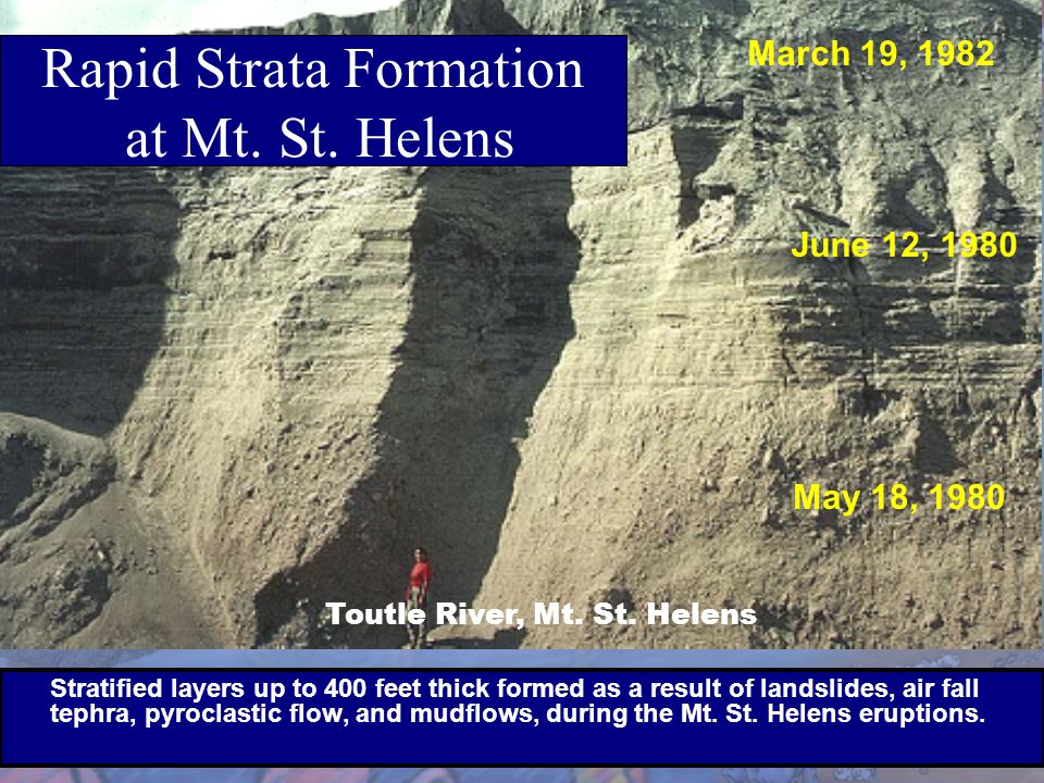
Rapid strata formation at Mount St Helens.
slideplayer.com/slide/5703217/18/images/28/Rapid+Strata+F...
www.flickr.com/photos/truth-in-science/39821536092
In the diagram (link above), (Y) which is the normal, everyday mechanism for strata formation (discovered by experiments), we can see that a fossil (A) in the top strata is actually older than a fossil (B) in the middle strata. And both fossils (A) & (B) are older than the fossil (C) in the bottom strata.
Put simply, when a stratified, sedimentary deposit is laid down in flowing water, all the strata upstream is deposited before all the strata downstream. This means all strata upstream is always older than all strata downstream.
So strata at the top can actually be older than strata at the bottom of a rock formation. Which strata is older in sedimentary rock can only be determined if we know the direction of the water current at the time the sedimentary deposit was laid down.
This completely overturns the idea that fossils found in lower strata must always be older than those in upper strata. it completely debunks the idea of index fossils (biostratigraphy) and of a fossil record based on depth of burial or geological/ecological eras.
Examples:
www.flickr.com/photos/truth-in-science/45113754412
www.flickr.com/photos/truth-in-science/29224301937
www.flickr.com/photos/truth-in-science/40393875072
www.flickr.com/photos/truth-in-science/44552032162
We now know, the Superposition Principle only applies on a rare occasion of sedimentary deposition in perfectly, still water. Superposition is required for the long evolutionary timescale, but the evidence shows it is not the general rule, as was once believed. Most sediment is laid down in moving water, where particle segregation is the general rule, resulting in the simultaneous deposition of strata/layers as shown in these photos ...
Rapid stratification with geological features: www.flickr.com/photos/101536517@N06/sets/72157635944904973/
Rapid, simultaneous formation of layers/strata, through particle segregation in moving water, is so easily created it has even been described by sedimentologists (working on flume experiments) as a law ...
"Upon filling the tank with water and pouring in sediments, we immediately saw what was to become the rule: The sediments sorted themselves out in very clear layers. This became so common that by the end of two weeks, we jokingly referred to Andrew's law as "It's difficult not to make layers," and Clark's law as "It's easy to make layers." Later on, I proposed the "law" that liquefaction destroys layers, as much to my surprise as that was." Ian Juby, www.ianjuby.org/sedimentation/
Examples in the photos www.flickr.com/photos/101536517@N06/sets/72157635944904973/
are the result of normal, everyday tidal action each occurring in a single incident. Where the water current or movement is more turbulent, violent, or catastrophic, considerable depths (many metres) of stratified sediment can be laid down in a short time. It does not require the many millions of years assumed to be necessary by evolutionists.
It is also evident that the composition of individual stratum formed in any deposition event. is related to whatever materials are in the sediment mix, not to any particular timescale. Whatever is in the mix will be automatically sorted into strata/layers. It could be sand, or other material added from mud slides, erosion of chalk deposits, coastal erosion, volcanic ash etc. Any organic material (potential fossils), alive or dead, engulfed by, or swept into, a turbulent sediment mix will also be sorted and buried within the rapidly, forming layers.
Experiments demonstrate the rapid, stratification principle.
and field evidence supports the work of the eminent, sedimentologist Dr Guy Berthault MIAS - Member of the International Association of Sedimentologists.
(Dr Berthault's experiments (www.sedimentology.fr/)
And also the experimental work of Dr M.E. Clark (Professor Emeritus, U of Illinois @ Urbana), Andrew Rodenbeck and Dr. Henry Voss, (www.ianjuby.org/sedimentation/)
Rapid strata formation videos:
A wealth of field evidence demonstrates that multiple strata in sedimentary deposits do not need millions of years to form and can be formed rapidly. The natural examples observed in field studies confirm the principle demonstrated by sedimentation experiments carried out by Dr Guy Berthault and other sedimentologists. It calls into question the widely accepted, multi-million year dating of sedimentary rocks, and the dating of fossils by depth of burial or position in the strata.
Dr Berthault's experiments (www.sedimentology.fr/) and other experiments (www.ianjuby.org/sedimentation/) combined with field studies of floods and volcanic action show that, rather than being formed by gradual, slow deposition of sucessive layers superimposed upon previous layers, with the strata or layers representing a particular timescale, particle segregation in moving water or airborne particles can form strata or layers very quickly, and frequently in a single event.
Most importantly, in such cases, lower strata are not older than upper strata, they are the same age, having been created in the same sedimentary episode.
Field studies of natural, stratification processes confirm the experiments carried out by sedimentologists and show that there is no longer any reason to conclude that strata/layers in sedimentary rocks relate to different geological eras and/or a multi-million year timescale. www.youtube.com/watch?v=5PVnBaqqQw8&feature=share&.... they also show that the relative position of fossils in rocks is not indicative of an order of evolutionary succession.
Obviously, the uniformitarian principle, on which the geologic column is based, can no longer be considered valid. And the multi-million, year dating of sedimentary rocks and fossils certainly needs to be reassessed.
The observed, rapid deposition of stratified sediments also explains the enigma of polystrate fossils, i.e. large fossils that intersect several strata. In some cases, tree trunk fossils are found which intersect the strata of sedimentary rock up to forty feet in depth. upload.wikimedia.org/wikipedia/commons/thumb/0/08/Lycopsi... They must have been buried in stratified sediment in a short time (certainly not millions, thousands, or even hundreds of years), or they would have rotted away. youtu.be/vnzHU9VsliQ
The vast majority of fossils are found in good, intact condition, which is testament to their rapid burial. You don't get good fossils from gradual burial, because they would be damaged or destroyed by decay, predation or erosion. The existence of so many fossils in sedimentary rock on a global scale is stunning evidence for the rapid depostion of sedimentary rock as the general rule. It is obvious that virtually all rock formations which contain good, intact fossils were formed from sediment laid down in a very short time, not millions, or even thousands of years.
See set of photos of other examples of rapid stratification: www.flickr.com/photos/101536517@N06/sets/72157635944904973/
Carbon dating of coal should not be possible if it is millions of years old, yet significant amounts of Carbon 14 have been detected in coal and other fossil material, which indicates that it is less than 50,000 years old. www.ldolphin.org/sewell/c14dating.html
www.grisda.org/origins/51006.htm
Evolutionists confidently cite multi-million year ages for rocks and fossils, but what most people don't realise is that no one actually knows the age of sedimentary rocks or the fossils found within them. So how are evolutionists so sure of the ages they so confidently quote? The astonishing thing is they aren't. Sedimentary rocks cannot be dated by radiometric methods*, and fossils can only be dated to less than 50,000 years with Carbon 14 dating. The method evolutionists use is based entirely on assumptions. Unbelievably, fossils are dated by the assumed age of rocks, and rocks are dated by the assumed age of fossils, that's right ... it is known as circular reasoning.
* Regarding the radiometric dating of igneous rocks, which is claimed to be relevant to the dating of sedimentary rocks, in an occasional instance there is an igneous intrusion associated with a sedimentary deposit -
Prof. Aubouin says in his Précis de Géologie: "Each radioactive element disintegrates in a characteristic and constant manner, which depends neither on the physical state (no variation with pressure or temperature or any other external constraint) nor on the chemical state (identical for an oxide or a phosphate)."
"Rocks form when magma crystallizes. Crystallisation depends on pressure and temperature, from which radioactivity is independent. So, there is no relationship between radioactivity and crystallisation.
Consequently, radioactivity doesn't date the formation of rocks. Moreover, daughter elements contained in rocks result mainly from radioactivity in magma where gravity separates the heavier parent element, from the lighter daughter element. Thus radiometric dating has no chronological signification." Dr. Guy Berthault www.sciencevsevolution.org/Berthault.htm
Radiometric dating based on unverifiable assumptions.
scienceagainstevolution.info/v8i8f.htm
Geology the dreadful science. Principle of Superposition falsified.
malagabay.wordpress.com/2013/07/08/geology-the-dreadful-s...
More about strata formation.
creation.com/geological-strata
Visit the fossil museum:
www.flickr.com/photos/101536517@N06/sets/72157641367196613/
Just how good are peer reviews of scientific papers?
www.sciencemag.org/content/342/6154/60.full
www.examiner.com/article/want-to-publish-science-paper-ju...
The neo-Darwinian idea that the human genome consists entirely of an accumulation of billions of mutations is, quite obviously, completely bonkers. Nevertheless, it is compulsorily taught in schools and universities as 'science'.
Some of the weathered rocks at Afghan Rocks.
Nullarbor #roundAustraliawithSpelio
PA234227
See some research on the Yilgarn Craton here..
www.sciencewa.net.au/topics/industry-a-resources/item/274...
A quick scan of a slide from my Ozimages Days
Mary peaks out of one of the Afghan Rocks near Balladonia, west Nullarbor.
Eyre Highway.
We had a trip out via Esperance and Mt Ragged in 1967, I think it was before Xmas sometime, in the old Beetle. Wandered around all the tracks and old homesteads from Israelite Bay up to Balladonia.
There is a story of Thomas Knowles shooting a cameleer here in the 1800s
www.wanowandthen.com/Afghans-in-Western-Australia.html
A word or two needs to be said about the importance of the Afghan camel drivers, who helped open up much of Western Australia (and indeed the rest of Australia as well) and who carted much needed supplies to the outback towns and stations.
Australia is 70% arid or semi-arid land and as a result it has the smallest population of all the world’s five continents. With so much desert to explore it comes as no surprise that camels and the men skilled in handling them were brought out to help open up the vast dry interior.
A high proportion of early settlers who came to Australia were ex-military men who had served in India. Here they had come into contact with camels and had seen the advantages they had over horses when travelling through areas of very low rainfall.
Although the word ‘Afghan’ is used as a universal description of the cameleers, their nationality varied considerably. They came from India, Pakistan, Iran, Turkey and of course Afghanistan. It is thought that the name Afghan stuck because the first cameleers and their camels arrived in South Australia aboard the ship Afghan.
The first camels brought to Australia were a single male and single female, shipped to Hobart in 1840. They were sent on to Melbourne and then Sydney but their ultimate fate remains unknown. Estimates put the number of Afghans that came out to Australia to act as cameleers to be around 3,000. What proportion of those came to W.A. is unknown.
The first camels to arrive in W.A. came with Ernest Giles in November 1875, after crossing the continent from Adelaide, but it was the discovery of gold in several centres that led to large numbers of Afghans and their camels making their way here.
It was on these same goldfields (supplied to a great extent by the cameleers) that racial tensions began to appear. Following are some excerpts from an article published in the Coolgardie Miner in June 1884:
'We calmly arise to protest in language simple and unadorned against the opening of our doors to aliens of Asiatic extraction... ...As a rule they are peaceful, obliging, industrious fellows, who interfere with no man's right;... ...Those Afghans who have pitched their tents amongst us seem a most exemplary lot of men... ...but we fear a low degenerate mongrel race of human beings will follow where they lead, and for the protection of our Anglo Saxon race we say and say emphatically... ...we have no use for you at present.'
Worse was to come and the same newspaper was responsible for publishing the following venomous diatribe:
'These Afghans, we are informed on unquestionable authority are well armed, and would have little hesitation in punctuating with bullets their objections to being interfered with. History furnishes us with vivid portrayals of the defilement of the dead women and children, and the awful horrors which have always followed even the temporary triumphs of the black man over the white, or the Moslem over the Christian.'
It just goes on getting worse and worse:
'The Asiatic has not come along in the march of civilisation as so far as to leave his instinct to kill behind him. When the Asiatic goes a little dotty; he runs amok, and strikes down all who come in his path.'
These articles were nothing more than incitement to public unrest and disorder.
As the Afghans were in competition with European haulers, who mostly used horses, there was some friction between the two groups. It was said that horses would baulk at drinking from wells where camels had been a short time before and that horses became nervous and skittish when camels were about.
One of the worst incidents to occur took place east of Esperance at a place now known as Afghan Rocks. Two parties, one with horses and one with camels, had camped near each other overnight and to start with relations were friendly.
Things went wrong when Tom Knowles found one of the Afghans (Noore Mahomet) washing his feet in the rock hole, polluting the water which was regarded as a sin in the water poor areas.
Knowles told Mahomet to get out of the water but the Afghan refused (washing of the feet is part of Muslim devotions). Knowles knocked Mahomet down and drew his pistol. Mahomet called for help from his companions who came to his aid throwing stones and carrying sticks. Knowles opened fire killing Jehan Mahomet and wounding Noore (who later died of his wounds).
Knowles ran out of ammunition and made a run for it, but he was caught, tied to a tree and beaten unconscious. Knowles’ companions were lured to the Afghan camp and seized, and like Knowles, they were tied up.
Historical picture of a camel and Afghan cameleer
The remaining Afghans discussed the situation and decided that rather than taking revenge, Knowles had to be handed over to the police (so much for Asiatics being unable to control themselves). The inevitable resulted with Knowles being acquitted by an all white jury.
The verdict was far from universally popular and Knowles, fearing for his life, fled to a remote corner of the Northern Territory.
As Muslims, the Afghans had an aversion to dealing with pork products and it was generally understood that they would not carry bacon. To get around this some traders used to put bacon into boxes labeled ‘beans’ or ‘rice’. On one occasion one of these boxes was found to be leaking bacon fat and the cameleer simply dumped all the goods his camels were carrying by the side of the road. The unlucky trader was left with a hefty loss of profits and had to re-supply the next camel train carefully omitting any boxes containing bacon.
Despite the friction between these two groups, the Afghans made an enormous contribution to the development of Western Australia and have been somewhat overlooked in many history books. In the end it was not racism that brought an end to the camel trains, it was the coming of the motor car.
see slide....
B2R37-28
Afghan Rock
Also in the area, on the Balladonia–Rawlinna Road,[13] are freshwater pools 14 km (8.7 mi) east at Afghan Rock(s), named for an cameleer who was shot nearby[14][15] on 13 October 1894.[16][17]
The pools were a vital stop for drinking water during the 19th century, when goods were being transported across the Nullarbor by teams of horses or camels,[15] especially during the days of the Western Australian gold rushes.[18] On this date, there were two groups of men and their beasts: white men, using horses, and "Afghan" cameleers. Tom Knowles, after noticing one of the "Afghan" cameleers, Noor(e) Mahomet, washing his feet in one of the rock holes (known as gnamma in WA). After being met with a refusal to desist, Knowles knocked Mahomet down and drew his gun. Mahomet's friends came to his aid, throwing stones and waving sticks. Knowles shot one of the other men dead and wounded Mahomet, who died later of his wounds. After running out of ammunition, he ran away, but the cameleers caught him, tied him to a tree, and beat him until he lost consciousness. His companions came to the Afghan camp, where they were tied up against trees for the night. In the morning, the cameleers untied the men, whereupon Knowles rode to Israelite Bay (then referred to as Point Malcolm[16]), 120 mi (190 km) away, and report the incident to police.[17][19]
The case was extensively reported in the newspapers at the time,[20][21] which also followed the trial of Knowles, on charges of manslaughter.[17] Knowles was acquitted, but the decision was controversial and Knowles fled to the Northern Territory.[19] The case is described in detail in The Ballad of Abdul Wade (2022), a book about cameleer Abdul Wade, by Ryan Butta.[17]
Today, Afghan Rock is accessible by soft roaders, but travellers need to obtain permission and directions from the manager of Balladonia Station.[15] It is approximately 447 m (1,467 ft) above sea level.[22]
Gros Morne
my photos arranged by subject, e.g. mountains - www.flickr.com/photos/29750062@N06/collections
my lichen photos by genus - www.flickr.com/photos/29750062@N06/collections/7215762439...
cimetière de Passy - Paris
Haroun Tazieff
(Warsaw, 11 May 1914 – Paris, 2 February 1998)
French volcanologist and geologist. He was a famous cinematographer of volcanic eruptions
né à Varsovie 11 mai 1914 - mort à Paris 2 février 1998
Vulcanologue - cinéaste - géologogue - écrivain pédagogique
expert de l'UNESCO - lauréat de l'Académie des Sciences en 1966 - maître de recherche au Centre National de la Recherche Scientifique (CNRS) en 1969 - directeur de recherche au CNRS en 1972 - président du conseil scientifique de l'Institut International de Recherches Volcanologiques (I.I.R.V.) (Rome, Catane, Pise) - Secrétaire d’État chargé de la prévention des risques naturels majeurs (1984-1986)
Pioneering geologist and founder member of the Royal Geographical Society.
We understand how our world was formed through the work of pioneering geologists like Murchison. There’s even a crater on the moon named after him!
Roderick was born in Ross-shire in Scotland, went to school in Durham and then to a military college. He served in the army for eight years, travelled in Italy with his wife for two, then returned to settle in County Durham.
There he met the inventor Sir Humphrey Davy, who introduced him to the new science of geology. It was to become his life’s passion. He studied the geology of the south of England, the south of France and the Alps, all the while reporting back to the Geological Society of London.
Roderick’s research into the ages and formation of the layers of rock in the Welsh borders resulted in his hugely influential book, The Silurian System, in 1839. He then helped establish the structures and events of the Devonian geological period in the south west of England. He went on to classify rocks in Russia and, towards the end of his life, studied the geology of Highland Scotland.
Roderick was a founder member of the Royal Geographical Society, and was its president four times. He was knighted for his work in 1846, and awarded a host of prizes and accolades for a lifetime of geological research and discovery. There are also towns, rivers and islands around the world named after him – and a crater on the moon.
Brompton Cemetery, Fulham Road, London
it was quite a climb to get up to this spot, but definitely worthwhile, as this contact--long thought to be depositional, turned out to be a fault --just as predicted by Sammy C., the geologist in this photo!
The Himalayas or Himalaya (/ˌhɪməˈleɪ.ə/ or /hɪˈmɑːləjə/) is a mountain range in the Indian subcontinent, which separates the Indo-Gangetic Plain from the Tibetan Plateau. Geopolitically, it covers the Himalayan states and regions. This range is home to nine of the ten highest peaks on Earth, including the highest above sea level, Mount Everest. The Himalayas have profoundly shaped the cultures of South Asia. Many Himalayan peaks are sacred in Dharmic religions such as Hinduism and Buddhism.
The Himalayas are bordered on the north by the Tibetan Plateau, on the south by the Indo-Gangetic Plain, on the northwest by the Karakoram and Hindu Kush ranges and on the east by the Indian states of Sikkim, the Darjeeling district of West Bengal, Assam, Arunachal Pradesh and Manipur. The Hindu Kush, Karakoram and Himalayas together form the "Hindu Kush Himalayan Region" (HKH). The western anchor of the Himalayas, Nanga Parbat, lies just south of the northernmost bend of the Indus River; the eastern anchor, Namcha Barwa, is just west of the great bend of the Yarlung Tsangpo River. The Himalayas span five countries: Nepal, India, Bhutan, China (Tibet), and Pakistan, the first three countries having sovereignty over most of the range.
Lifted by the collision of the Indian tectonic plate with the Eurasian Plate, the Himalayan range runs northwest to southeast in a 2,400-kilometre-long arc. The range varies in width from 400 kilometres in the west to 150 kilometres in the east. Besides the Greater Himalayas, there are several parallel lower ranges. The southernmost, along the northern edge of the Indian plains and reaching 1000 m in altitude, is the Sivalik Hills. Further north is a higher range, reaching 2000–3000 m, known as the Lower Himalayan Range.
Three of the world's major rivers (the Indus, the Ganges and the Brahmaputra) arise in the Himalayas. While the Indus and the Brahmaputra rise near Mount Kailash in Tibet, the Ganges rises in the Indian state of Uttarakhand. Their combined drainage basin is home to some 600 million people.
ETYMOLOGY
The name Himālaya is from Sanskrit: hima (snow) + ālaya (dwelling), and literally means "abode of snow"
ECOLOGY
The flora and fauna of the Himalayas vary with climate, rainfall, altitude, and soils. The climate ranges from tropical at the base of the mountains to permanent ice and snow at the highest elevations. The amount of yearly rainfall increases from west to east along the southern front of the range. This diversity of altitude, rainfall and soil conditions combined with the very high snow line supports a variety of distinct plant and animal communities. The extremes of high altitude (low atmospheric pressure) combined with extreme cold favor extremophile organisms.
The unique floral and faunal wealth of the Himalayas is undergoing structural and compositional changes due to climate change. The increase in temperature is shifting various species to higher elevations. The oak forest is being invaded by pine forests in the Garhwal Himalayan region. There are reports of early flowering and fruiting in some tree species, especially rhododendron, apple and box myrtle. The highest known tree species in the Himalayas is Juniperus tibetica located at 4,900 metres in Southeastern Tibet.
GEOLOGY
The Himalayan range is one of the youngest mountain ranges on the planet and consists mostly of uplifted sedimentary and metamorphic rock. According to the modern theory of plate tectonics, its formation is a result of a continental collision or orogeny along the convergent boundary between the Indo-Australian Plate and the Eurasian Plate. The Arakan Yoma highlands in Myanmar and the Andaman and Nicobar Islands in the Bay of Bengal were also formed as a result of this collision.
During the Upper Cretaceous, about 70 million years ago, the north-moving Indo-Australian plate (which has subsequently broken into the Indian Plate and the Australian plate) was moving at about 15 cm per year. About 50 million years ago this fast moving Indo-Australian plate had completely closed the Tethys Ocean, the existence of which has been determined by sedimentary rocks settled on the ocean floor, and the volcanoes that fringed its edges. Since both plates were composed of low density continental crust, they were thrust faulted and folded into mountain ranges rather than subducting into the mantle along an oceanic trench. An often-cited fact used to illustrate this process is that the summit of Mount Everest is made of marine limestone from this ancient ocean.
Today, the Indian plate continues to be driven horizontally below the Tibetan Plateau, which forces the plateau to continue to move upwards. The Indian plate is still moving at 67 mm per year, and over the next 10 million years it will travel about 1,500 km into Asia. About 20 mm per year of the India-Asia convergence is absorbed by thrusting along the Himalaya southern front. This leads to the Himalayas rising by about 5 mm per year, making them geologically active. The movement of the Indian plate into the Asian plate also makes this region seismically active, leading to earthquakes from time to time.
During the last ice age, there was a connected ice stream of glaciers between Kangchenjunga in the east and Nanga Parbat in the west. In the west, the glaciers joined with the ice stream network in the Karakoram, and in the north, joined with the former Tibetan inland ice. To the south, outflow glaciers came to an end below an elevation of 1,000–2,000 metres. While the current valley glaciers of the Himalaya reach at most 20 to 32 kilometres in length, several of the main valley glaciers were 60 to 112 kilometres long during the ice age. The glacier snowline (the altitude where accumulation and ablation of a glacier are balanced) was about 1,400–1,660 metres lower than it is today. Thus, the climate was at least 7.0 to 8.3 °C colder than it is today.
HYDROLOGY
The Himalayas contain the third-largest deposit of ice and snow in the world, after Antarctica and the Arctic. The Himalayan range encompasses about 15,000 glaciers, which store about 12,000 km3 of fresh water. Its glaciers include the Gangotri and Yamunotri (Uttarakhand) and Khumbu glaciers (Mount Everest region), Langtang glacier (Langtang region) and Zemu (Sikkim).
Owing to the mountains' latitude near the Tropic of Cancer, the permanent snow line is among the highest in the world at typically around 5,500 metres. In contrast, equatorial mountains in New Guinea, the Rwenzoris and Colombia have a snow line some 900 metres lower. The higher regions of the Himalayas are snowbound throughout the year, in spite of their proximity to the tropics, and they form the sources of several large perennial rivers, most of which combine into two large river systems:
- The western rivers, of which the Indus is the largest, combine into the Indus Basin. The Indus begins in Tibet at the confluence of Sengge and Gar rivers and flows southwest through India and then through Pakistan to the Arabian Sea. It is fed by the Jhelum, the Chenab, the Ravi, the Beas, and the Sutlej rivers, among others.
- Most of the other Himalayan rivers drain the Ganges-Brahmaputra Basin. Its main rivers are the Ganges, the Brahmaputra and the Yamuna, as well as other tributaries. The Brahmaputra originates as the Yarlung Tsangpo River in western Tibet, and flows east through Tibet and west through the plains of Assam. The Ganges and the Brahmaputra meet in Bangladesh, and drain into the Bay of Bengal through the world's largest river delta, the Sunderbans.
The easternmost Himalayan rivers feed the Irrawaddy River, which originates in eastern Tibet and flows south through Myanmar to drain into the Andaman Sea.
The Salween, Mekong, Yangtze and Huang He (Yellow River) all originate from parts of the Tibetan Plateau that are geologically distinct from the Himalaya mountains, and are therefore not considered true Himalayan rivers. Some geologists refer to all the rivers collectively as the circum-Himalayan rivers. In recent years, scientists have monitored a notable increase in the rate of glacier retreat across the region as a result of global climate change. For example, glacial lakes have been forming rapidly on the surface of debris-covered glaciers in the Bhutan Himalaya during the last few decades. Although the effect of this will not be known for many years, it potentially could mean disaster for the hundreds of millions of people who rely on the glaciers to feed the rivers during the dry seasons.
LAKES
The Himalayan region is dotted with hundreds of lakes. Most lakes are found at altitudes of less than 5,000 m, with the size of the lakes diminishing with altitude. Tilicho Lake in Nepal in the Annapurna massif is one of the highest lakes in the world. Pangong Tso, which is spread across the border between India and China, and Yamdrok Tso, located in central Tibet, are amongst the largest with surface areas of 700 km², and 638 km², respectively. Other notable lakes include She-Phoksundo Lake in the Shey Phoksundo National Park of Nepal, Gurudongmar Lake, in North Sikkim, Gokyo Lakes in Solukhumbu district of Nepal and Lake Tsongmo, near the Indo-China border in Sikkim.
Some of the lakes present a danger of a glacial lake outburst flood. The Tsho Rolpa glacier lake in the Rowaling Valley, in the Dolakha District of Nepal, is rated as the most dangerous. The lake, which is located at an altitude of 4,580 metres has grown considerably over the last 50 years due to glacial melting.
The mountain lakes are known to geographers as tarns if they are caused by glacial activity. Tarns are found mostly in the upper reaches of the Himalaya, above 5,500 metres.
IMPACT ON CLIMATE
The Himalayas have a profound effect on the climate of the Indian subcontinent and the Tibetan Plateau. They prevent frigid, dry winds from blowing south into the subcontinent, which keeps South Asia much warmer than corresponding temperate regions in the other continents. It also forms a barrier for the monsoon winds, keeping them from traveling northwards, and causing heavy rainfall in the Terai region. The Himalayas are also believed to play an important part in the formation of Central Asian deserts, such as the Taklamakan and Gobi.
RELIGIOUS OF THE REGION
In Hinduism, the Himalayas have been personified as the god Himavat, father of Ganga and Parvati.
Several places in the Himalayas are of religious significance in Buddhism, Hinduism, Jainism and Sikhism. A notable example of a religious site is Paro Taktsang, where Padmasambhava is said to have founded Buddhism in Bhutan. Padmasambhava is also worshipped as the patron saint of Sikkim.
A number of Vajrayana Buddhist sites are situated in the Himalayas, in Tibet, Bhutan and in the Indian regions of Ladakh, Sikkim, Arunachal Pradesh, Spiti and Darjeeling. There were over 6,000 monasteries in Tibet, including the residence of the Dalai Lama. Bhutan, Sikkim and Ladakh are also dotted with numerous monasteries. The Tibetan Muslims have their own mosques in Lhasa and Shigatse.
RESOURCES
The Himalayas are home to a diversity of medicinal resources. Plants from the forests have been used for millennia to treat conditions ranging from simple coughs to snake bites. Different parts of the plants - root, flower, stem, leaves, and bark - are used as remedies for different ailments. For example, a bark extract from an abies pindrow tree is used to treat coughs and bronchitis. Leaf and stem paste from an arachne cordifolia is used for wounds and as an antidote for snake bites. The bark of a callicarpa arborea is used for skin ailments. Nearly a fifth of the gymnosperms, angiosperms, and pteridophytes in the Himalayas are found to have medicinal properties, and more are likely to be discovered.
Most of the population in some Asian and African countries depend on medicinal plants rather than prescriptions and such (Gupta and Sharma, vii). Since so many people use medicinal plants as their only source of healing in the Himalayas, the plants are an important source of income. This contributes to economic and modern industrial development both inside and outside the region (Gupta and Sharma, 5). The only problem is that locals are rapidly clearing the forests on the Himalayas for wood, often illegally (Earth Island Journal, 2). This means that the number of medicinal plants is declining and that some of them might become rarer or, in some cases, go extinct.
Although locals are clearing out portions of the forests in the Himalayas, there is still a large amount of greenery ranging from the tropical forests to the Alpine forests. These forests provide wood for fuel and other raw materials for use by industries. There are also many pastures for animals to graze upon (Mohita, sec. Forest and Wealth). The many varieties of animals that live in these mountains do so based on the elevation. For example, elephants and rhinoceros live in the lower elevations of the Himalayas, also called the Terai region. Also, found in these mountains are the Kashmiri stag, black bears, musk deer, langur, and snow leopards. The Tibetan yak are also found on these mountains and are often used by the people for transportation. However, the populations of many of these animals and still others are declining and are on the verge of going extinct (Admin, sec. Flora and Fauna).
The Himalayas are also a source of many minerals and precious stones. Amongst the tertiary rocks, are vast potentials of mineral oil. There is coal located in Kashmir, and precious stones located in the Himalayas. There is also gold, silver, copper, zinc, and many other such minerals and metals located in at least 100 different places in these mountains (Mohita, sec. Minerals).
CULTURE
There are many cultural aspects of the Himalayas. For the Hindus, the Himalayas are personified as Himavath, the father of the goddess Parvati (Gupta and Sharma, 4). The Himalayas is also considered to be the father of the river Ganges. The Mountain Kailash is a sacred peak to the Hindus and is where the Lord Shiva is believed to live (Admin, sec. Centre of Religion). Two of the most sacred places of pilgrimage for the Hindus is the temple complex in Pashupatinath and Muktinath, also known as Saligrama because of the presence of the sacred black rocks called saligrams (Zurick, Julsun, Basanta, and Birendra, 153).
The Buddhists also lay a great deal of importance on the mountains of the Himalayas. Paro Taktsang is the holy place where Buddhism started in Bhutan (Admin, sec. Centre of Religion). The Muktinath is also a place of pilgrimage for the Tibetan Buddhists. They believe that the trees in the poplar grove came from the walking sticks of eighty-four ancient Indian Buddhist magicians or mahasiddhas. They consider the saligrams to be representatives of the Tibetan serpent deity known as Gawo Jagpa (Zurick, Julsun, Basanta, and Birendra, 153).
The Himalayan people’s diversity shows in many different ways. It shows through their architecture, their languages and dialects, their beliefs and rituals, as well as their clothing (Zurick, Julsun, Basanta, and Birendra, 78). The shapes and materials of the people’s homes reflect their practical needs and the beliefs. Another example of the diversity amongst the Himalayan peoples is that handwoven textiles display unique colors and patterns that coincide with their ethnic backgrounds. Finally, some people place a great importance on jewelry. The Rai and Limbu women wear big gold earrings and nose rings to show their wealth through their jewelry (Zurick, Julsun, Basanta, and Birendra, 79).
WIKIPEDIA
While studying thrust faults along the northeastern tip of the Tibetan Plateau in Gansu Province, China, we (five Chinese geologists and three American geologists, including me) walked over a ridge and saw this nomadic woman and her son. I've always been impressed with her composure and trust, even though the men from her camp were out tending the sheep and in the group facing her (the geologists) there were three individuals who probably looked strange, especially the two tall ones with facial hair (I'm one of those two). Yes, I did ask to take her picture. More power to her, even though it is now 30 years later.
from just below the Garganta
geologist Joe Vance just finished belaying me
obituaries.seattletimes.com/obituary/joseph-vance-1083770417
from a kodachrome 25 slide, 1975
the other side of Huascaran Norte is quite difficult, see www.flickr.com/photos/29750062@N06/4225454753/
my lichen photos by genus - www.flickr.com/photos/29750062@N06/collections/7215762439...
my photos arranged by subject, e.g. mountains - www.flickr.com/photos/29750062@N06/collections
Normally GSWA field geologists headed back to Perth when the weather heated up, but Bill and I stayed through November and December because we planned to meet up with an expedition of NSW cavers in Jan 1966 so that we could safely examine the very extensive Mullamullang. The thick sweater of an earlier slide was shed as the weather heated up.
We used a Flying Doctor radio with a telescopic aerial for communications. As a gesture towards safety, we sent a telegram to the Perth office once a week reporting our location and our intentions for the next week. However, the possibility of rolling the LandRover and draining the battery acid was always a concern. Maybe later while chasing roos...
Map location approx only anywhere flat and empty on the northern Nullarbor...
Kodachrome by one of us! Films sent via post from Balladonia or Rawlinna to Kodak!
All the DL TIF files from the CD of Dave's Nullarbor Caves & Geol 1962-68 are filed in the CD drawer.
Several were edited and loaded years ago..
We shared films during the GSWA mapping expedition during 1965.
Geologists: could this be a remnant of an original sedimentary structure in these 1.7 B.Y. metasediments near Blackhawk, CO?
The boys are really into rocks and gems these days and as he sat in our front yard trying to break open a geode - I just looked and thought "where does the time go?" One day they are picking up rocks to throw in the river and the next they are breaking them open to learn all about them.
This is not to say they still don't love throwing rocks in the river...that never gets old.
Carte de visite by an unidentified photographer. I recently added this Civil War era image to my collection because I was drawn to the uncommon subject matter: A man with thick sideburns leans into an easel as he touches his brush against an albumen print of a woman. The brushes, paints, and glass of liquid, spirits or water, indicate he is a colorist or retoucher adding highlights to the woman’s dress. Another print, of a gray-bearded man, leans against the wall, either drying or waiting for the artist’s touch. Below the desk upon which the easel sits is a large four-lens wet-plate camera used for making carte de visite portraits—those paper images about the size of a modern trading card that were the social media own the 1860s.
The print is mounted on card stock, consistent with cartes from this period. The square edges have been trimmed so that the images can be easily slid into the thick and unforgiving pages of a photo album without creasing the picture.
The back of the mount includes an inscription printed in modern pencil:
Clarence C. King
Gardner’s Studio
Wash, D.C.
Ex coll. Alfred R. Waud
So this is what we know from a physical examination of the image.
The previous owner of this image, or caretaker as I like to think, provided additional information. He is William L. Schaeffer, a man well known in 19th century photograph collecting circles. Over 700 extraordinary photographs from Willie’s collection are now part of the Metropolitan Museum of Art.
Willie shared the image’s provenance: From noted Civil War artist Alfred R. Waud, to collector and dealer George R. Rinhart, to New York City dealer of fine photographica Allen Weiner, and acquired by Willie about 1985. Willie had the image in his collection for 40 years before it came to me.
In my experience as a collector, it is rare to trace the history of a photograph from its creation to the present time.
Willie also included this descriptive information:
“An excellent and extremely rare vintage museum quality carte-de-visite of Clarence C. King, an employee in the Washington, D.C. studio of Alexander Gardner, at work coloring a huge photograph of the First Lady, Mary Todd Lincoln. There is a large four-tube wet-plate camera beneath the table at his feet. Unsigned but most likely photographed by Alexander Gardner or another operator in the studio. 1860s.”
Armed with Willie’s information, and what I had observed with my own eyes, I did what I always do with a new acquisition to my collection: I turned to research to validate it. I always go into these projects as a healthy skeptic. In this case, I went in with heightened skepticism because the identification was modern, not period. Modern identifications are the least trustworthy, based on a survey of researchers about IDs by my friend Dr. Kurt Luther at Virginia Tech. Kurt developed Civil War Photo Sleuth, a digital tool tat used face recognition, technology, and community to identify soldiers.
My skepticism was heightened a bit more because the photograph of the woman looked younger than images I’ve seen of Mary Todd Lincoln. It is not a pose that I recognize. Still, I did not discount it because the details of the face and clothing are hard to make out.
My first step was to find Clarence C. King. I immediately ran into trouble. Searches on Ancestry.com, Find A Grave and elsewhere turned up no leads. I did however find one man with a very similar name: Clarence Rivers King (1841-1901).
As I began to learn more about King, my confidence rose. A Yale graduate who associated with a group of artists, writers and architects who followed the intellectual British polymath James Ruskin, King became a geologist and explored the American West. Just after the Civil War, King persuaded the U.S. Congress to fund an 1867 survey that came to be known as the Geological Exploration of the Fortieth Parallel, or the Fortieth Parallel Survey. King led the group as U.S. Geologist, and he hired photographer Timothy O’Sullivan, who had worked for Mathew Brady and Alexander Gardner during the late Civil War, to document the trip. The survey was extremely successful, leading to King’s 1872 book, “Mountaineering in the Sierra Nevada.”
King’s history fits nicely with the inscription on the back of the mount. He hung out with artists, and Alfred Waud was an illustrator. The photographer he hired for the geological survey, Timothy O’Sullivan, had once worked for Gardner’s Studio. But two items gave me pause.
First, Why would King pose as a colorist? There was another important consideration:
Second, likenesses of the geologist Clarence Rivers King did not match the colorist believed to be Clarence C. King.
I had hit a dead end.
A few days later, I contacted Military Images Senior Editor Buck Zaidel about a project centered around wartime images of wounded soldiers and sailors. It will be the cover story of our Spring 2025 issue. As the conversation wrapped up, we swapped stories about our latest acquisitions—something we always do when we talk. When I mentioned this image, described it, and explained that my research had stalled, Buck surprised me by saying he had a copy of the same print and was quite sure that his version had a name on the back—and that the name was not King. Excited, I sent Buck a phone pic to make sure we were talking about the same image.
He responded with a phone pic of the front and back of his carte de visite. I was delighted to see it was in fact the same print, and thrilled to look upon the period signature in bold ink on the back: Clarence Eytinge—not Clarence C. King.
Thanks to Buck, I now had an airtight identification of our colorist! The uniqueness of his surname made researching his life relatively easy. Eytinge (1835-1900), one of a dozen children born in America to wealthy Dutch immigrants of the Jewish faith, hailed from an multitalented family that excelled in the arts.
Eytinge’s eldest brother, Henry St. Claire “Harry” Eytinge (1822-1902) acted on stage alongside the Booth family, Edward Forrest, Charlotte Cushman, and others. Another older brother, Charles Dennis Eytinge, became a Shakespearian scholar well known in New York City’s literary scene.
A cousin, Rosetta “Rose” Eytinge (1835-1911), one of the most popular American actors of the day, toured major cities. President Abraham Lincoln numbered among her legion of fans.
Eytinge followed another older brother, Sol Eytinge, Jr., in pursuit of a career as an artist. Sol became a staff artist at “Frank Leslie’s Illustrated Newspaper” and mentored a young up-and-coming artist named Thomas Nast. Sol also contributed to “Harper’s Weekly,” where be befriended the Waud brothers, Alfred and William. Sol illustrated books for prominent authors of the time, including Louisa May Alcott, Charles Dickens, Oliver Wendell Holmes, James Russell Lowell, John Greenleaf Whittier, and others.
Eytinge and Sol worked together as lithographers in the 1850s. One of Eytinge’s early works, created in 1853 at age 18, is a lithograph of New York City’s Park Row, is in the collection of the Museum of the City of New York:
collections.mcny.org/CS.aspx?VP3=DamView&VBID=&PN...
The Eytinge brothers were also gamblers, according to fellow illustrator Thomas Butler Gunn (1826-1904): “Clarence Eytinge has followed in the track of more than one of his brothers and gets his living at the gaming table.”
Eytinge’s career path changed after the Civil War began. In 1862, Eytinge relocated to Washington, D.C., and joined the administration of President Abraham Lincoln as a clerk in William Henry Seward’s Department of State. In this position, according to a news report, he became “well known and appreciated for his gentlemanly character and scholarly attainments.”
Eytinge was of military age, but was exempted from service due to a physical disability according to a Washington, D.C., newspaper. The report did not note the nature of the disability.
While Eytinge clerked as the State Department, Lincoln signed into law An Act to Encourage Immigration. The act, signed into law on On July 4, 1864, defended the rights of immigrants and sought to facilitate lawful immigration, especially by skilled European workers to fill the void left by Union soldiers in the army or those who had died in its service. It marked the first federal immigration law in the country. Eytinge transferred to the new Immigration Bureau before the end of 1864.
A year layer, Eytinge became Secretary of the United States Legation at Lima, Peru. He served in this capacity until March 1867, when he resigned and returned to Washington and continued to work in the State Department until the administration of President Ulysses S. Grant took office on March 4, 1869. Thus ended Eytinge’s career in the arts of diplomacy.
Eytinge returned to New York City and opened a design business, which included decorating event spaces, such as an 1881 ball to commemorate the centennial of the Revolutionary War victory at Yorktown.
In the late 1890s, Eytinge’s health began to fail, and Brig. Gen. William Henry Seward, Jr., the youngest son of the secretary, found him a less stressful job with the Adams Express Company. He died in 1900 of kidney issues and was survived by his wife, Catherine, whom he had married in 1856.
Still unknown is who owned the camera and created the photograph. The body of evidence points to Alexander Gardner, a friend of brother Sol. But we cannot say with certainty that it is Gardner’s studio.
I encourage you to use this image for educational purposes only. However, please ask for permission.
Source: en.wikipedia.org/wiki/Grand_Canyon
The Grand Canyon is a steep-sided canyon carved by the Colorado River in Arizona, United States. The Grand Canyon is 277 miles (446 km) long, up to 18 miles (29 km) wide and attains a depth of over a mile (6,093 feet or 1,857 meters).
The canyon and adjacent rim are contained within Grand Canyon National Park, the Kaibab National Forest, Grand Canyon–Parashant National Monument, the Hualapai Indian Reservation, the Havasupai Indian Reservation and the Navajo Nation. The surrounding area is contained within the Baaj Nwaavjo I'tah Kukveni – Ancestral Footprints of the Grand Canyon National Monument. President Theodore Roosevelt was a major proponent of the preservation of the Grand Canyon area and visited it on numerous occasions to hunt and enjoy the scenery.
Nearly two billion years of Earth's geological history have been exposed as the Colorado River and its tributaries cut their channels through layer after layer of rock while the Colorado Plateau was uplifted. While some aspects about the history of incision of the canyon are debated by geologists, several recent studies support the hypothesis that the Colorado River established its course through the area about 5 to 6 million years ago. Since that time, the Colorado River has driven the down-cutting of the tributaries and retreat of the cliffs, simultaneously deepening and widening the canyon.
For thousands of years, the area has been continuously inhabited by Native Americans, who built settlements within the canyon and its many caves. The Pueblo people considered the Grand Canyon a holy site, and made pilgrimages to it. The first European known to have viewed the Grand Canyon was García López de Cárdenas from Spain, who arrived in 1540.
Source: en.wikipedia.org/wiki/Grand_Canyon_National_Park
Grand Canyon National Park is a national park of the United States located in northwestern Arizona, the 15th site to have been named as a national park. The park's central feature is the Grand Canyon, a gorge of the Colorado River, which is often considered one of the Wonders of the World. The park, which covers 1,217,262 acres (1,901.972 sq mi; 4,926.08 km2) of unincorporated area in Coconino and Mohave counties, received more than 4.7 million recreational visitors in 2023. The Grand Canyon was designated a World Heritage Site by UNESCO in 1979. The park celebrated its 100th anniversary on February 26, 2019.
Source: www.nps.gov/grca/index.htm
Entirely within the state of Arizona, the park encompasses 278 miles (447 km) of the Colorado River and adjacent uplands. Located on the ancestral homelands of 11 present day Tribal Communities, Grand Canyon is one of the most spectacular examples of erosion anywhere in the world—a mile deep canyon unmatched in the incomparable vistas it offers visitors from both north and south rims.
Additional Foreign Language Tags:
(United States) "الولايات المتحدة" "Vereinigte Staaten" "アメリカ" "米国" "美国" "미국" "Estados Unidos" "États-Unis" "ארצות הברית" "संयुक्त राज्य" "США"
(Arizona) "أريزونا" "亚利桑那州" "אריזונה" "एरिजोना" "アリゾナ州" "애리조나" "Аризона"
(Grand Canyon) "جراند كانيون" "大峡谷" "גרנד קניון" "ग्रांड कैन्यन" "グランドキャニオン" "그랜드 캐니언" "Гранд-Каньон" "Gran Cañón"
Antonio Stoppani (24 August 1824 – 1 January 1891) was an Italian Catholic priest, patriot, geologist and palaeontologist. He studied the geology of the Italian region and wrote a popular treatise, Il Bel Paese (Italian for "the beautiful country"), on geology and natural history. He was among the first to propose a geological epoch dominated by human activities that altered the shape of the land.
Life
Born in Lecco, Stoppani studied theology and became a priest in the order of the Rosminians. He was ordained in 1848, a year of turmoil with the Siege of Milan. During this siege, the Five Days of Milan, he became a hero for his role in the use of hot air balloons to send messages out of the besieged city. Along with Vincenzo Guglielmini, he ensured that the balloons could move over the walls of the city from the Seminario Maggiore di Porta Orientale and carry messages to rally the Italians against the Austrian Empire. He later became professor of geology in the Royal Technical Institute of Milan, and was distinguished for his research on the Triassic and Liassic formations of northern Italy.
Plaque in front of Chiesa di San Giovanni in Esino Lario
Stoppani was important as a popularizer of science. His most popular work, Il Bel Paese, conversazioni sulle bellezze naturali la geologia e la geologia e la geografia fisica d'Italia (1876) ("The Beautiful country, conversation on the natural beauty of geology and the physical geography of Italy"), after which Bel Paese cheese was named by Egidio Galbani (the wrapper for the cheese included a portrait of Stoppani). It presents, by means of 32 didactic, scientific conversations supposedly in front of a fireplace, ideas and concepts from the natural sciences, in language accessible to the average 19th-century reader. It was so popular that it went into 120 editions by 1920 and was a textbook in schools. It deals especially with geological curiosities and the beauty of the Italian landscape. He commented on Italians who "know almost nothing about the natural beauty of our country; yet take delight when someone calls it a garden" and that the English fall in love with just one thing and devote their energies, emotions, and life to arrive dead or alive at the summit of mountains. His introduction to natural history declared that "man should never disappear from nature, nor should nature disappear from man". Stoppani, like many other clergyman naturalists of the period, was a supporter of the concordismo, a school of thought that sought to find concordance between the teachings of the bible and evidence from geology. He promoted the idea that Catholics needed to learn science and that the bible was to be interpreted rather than taken literally. He was also an important figure in "Catholic Alpinism", a movement that sought to use mountains to tell God's glory. Stoppani was however a critic of the ideas of evolution that Darwin's publication had brought into Europe.
Stoppani's works on paleontology and geology include:
Paleontologie Lombarde (1858–1881)
Les Pétrifications d'Ésino, ou Description des fossiles appartenant au dépôt triasique supérieur des environs d'Esino en Lombardie] (1858–1860)
Géologie et paleontologie des conches a Avicula Contorta en Lombardie (1860–1865)
Corso di geologia (3 vols, 1871–1873) [ vol. 1 | vol. 2 | vol. 3 ]
Geologia d'Italia
Volume 1: Descrizione del terreni componenti il suolo d'Italia (1874)
Volume 2: L'Era Neozoica (1880)
In this last work the author discussed the glaciation of the Italian Alps and the history of Italy during the Pleistocene age. Stoppani described several species of fossil molluscs while other fossil species have been named in his honour, including Fedaiella stoppanii Marini 1896 (a snail), Placochelyanus stoppanii Oswald 1930, Lymnaea stoppanianus Coppi, 1876 and Gyraulus (Gyraulus) stoppanii (Sacco, 1886).[11] Most of his collections are in the Museo di Storia Naturale, Milano, the building of which he was responsible for constructing as director from 1882 to 1891. Stoppani Glacier in Tierra del Fuego is named after him.
Stoppani was the great-uncle of Maria Montessori, famous for her work on education; he was the uncle of Maria's mother Renilde. The Italian painter Giovanni Battista Todeschini (1857–1938) was his nephew. An oil painting of Stoppani made by Todeschini is held in the Public Museum at Lecco.
Anthropocene
In 1873 Stoppani acknowledged the increasing power and impact of humanity on the Earth's systems and referred to the anthropozoic era an idea that was possibly based on George Perkins Marsh who lived in Italy and whose work, Man and Nature, was translated into Italian in 1872. In a later edition of Man and Nature published as The Earth as Modified by Human Action in 1874, Marsh noted:
In a former chapter I spoke of the influence of human action on the surface of the globe as immensely superior in degree to that exerted by brute animals, if not essentially different from it in kind. The eminent Italian geologist, Stoppani, goes further than I had ventured to do, and treats the action of man as a new physical element altogether sui generis. According to him, the existence of man constitutes a geological period which he designates as the Anthropozoic era. ‘The creation of man’, says he, ‘was the introduction of a new element into nature, of a force wholly unknown to earlier periods’.
The idea of a new geological epoch, the anthropocene, was proposed in 2000 by Paul Crutzen and Eugene Stoermer. While some have pointed to the ideas of Marsh, Stoppani, Teilhard de Chardin and Vladimir Vernadsky (noösphere) as precursors, others have pointed out a distinction in the geological epoch proposed by Crutzen. Whereas the effects of man proposed in the past were small and gradual, the effects are sharply marked in Crutzen's anthropocene.
Milan is a city in Northern Italy, regional capital of Lombardy, and the second-most populous city proper in Italy after Rome. The city proper has a population of about 1.4 million, while its metropolitan city has 3.22 million residents The urban area of Milan is the fourth largest in the EU with 5.27 million inhabitants. According to national sources, the population within the wider Milan metropolitan area (also known as Greater Milan), is estimated between 4.9 million and 7.4 million making it by far the largest metropolitan area in Italy and one of the largest in the EU. Milan is the economic capital of Italy and is a global financial centre. Milan is, together with London, Hamburg, Frankfurt, Munich and Paris, one of the six European economic capitals.
Milan is a leading alpha global city, with strengths in the fields of art, chemicals, commerce, design, education, entertainment, fashion, finance, healthcare, media (communication), services, research and tourism. Its business district hosts Italy's stock exchange (Italian: Borsa Italiana), and the headquarters of national and international banks and companies. In terms of GDP, Milan is the wealthiest city in Italy, has the third-largest economy among EU cities after Paris and Madrid, and is the wealthiest among EU non-capital cities. Milan is viewed along with Turin as the southernmost part of the Blue Banana urban development corridor (also known as the "European Megalopolis"), and one of the Four Motors for Europe. Milan is one of the international tourism destinations, appearing among the forty most visited cities in the world, ranking second in Italy after Rome, fifth in Europe and sixteenth in the world. Milan is a major cultural centre, with museums and art galleries that include some of the most important collections in the world, such as major works by Leonardo da Vinci. It also hosts numerous educational institutions, academies and universities, with 11% of the national total of enrolled students.
Founded around 590 BC under the name Medhelanon by a Celtic tribe belonging to the Insubres group and belonging to the Golasecca culture, it was conquered by the ancient Romans in 222 BC, who latinized the name of the city into Mediolanum. The city's role as a major political centre dates back to the late antiquity, when it served as the capital of the Western Roman Empire. From the 12th century until the 16th century, Milan was one of the largest European cities and a major trade and commercial centre; consequently, it became the capital of the Duchy of Milan, one of the greatest political, artistic and fashion forces in the Renaissance. Having become one of the main centres of the Italian Enlightenment during the early modern period, the city subsequently became the industrial and financial capital of modern Italy. Capital of the Napoleonic Kingdom of Italy, after the Restoration it was among the most active centres of the Risorgimento, until its entry into the unified Kingdom of Italy.
Milan has been recognized as one of the world's four fashion capitals. Many of the most famous luxury fashion brands in the world have their headquarters in the city, including: Armani, Prada, Versace, Moschino, Valentino and Zegna. It also hosts several international events and fairs, including Milan Fashion Week and the Milan Furniture Fair, which are among the world's biggest in terms of revenue, visitors and growth. The city is served by many luxury hotels and is the fifth-most starred in the world by Michelin Guide. It hosted the Universal Exposition in 1906 and 2015. In the field of sports, Milan is home to two of Europe's most successful football teams, AC Milan and Inter Milan, and one of Europe's main basketball teams, Olimpia Milano. Milan will host the Winter Olympic and Paralympic games for the first time in 2026, together with Cortina d'Ampezzo.
Milan, Italy is an ancient city in northern Italy first settled under the name Medhelanon in about 590 BC by a Celtic tribe belonging to the Insubres group and belonging to the Golasecca culture.[1][2] The settlement was conquered by the Romans in 222 BC and renamed it Mediolanum. Diocletian divided the Roman Empire, choosing the eastern half for himself, making Milan the seat of the western half of the empire, from which Maximian ruled, in the late 3rd and early 4th century AD. In 313 AD Emperors Constantine and Licinius issued the Edict of Milan, which officially ended the persecution of Christians. In 774 AD, Milan surrendered to Charlemagne and the Franks.
During the Middle Ages, the city's history was the story of the struggle between two political factions: the Guelphs and the Ghibellines. Finally the Visconti family took power (signoria) in Milan. In 1395 Emperor Wenceslas made Milan a duchy, thus raising the dignity of the city's citizens. In the mid-15th century the Ambrosian Republic was established, taking its name from St. Ambrose, a beloved patron saint of the city. The two rival factions worked together to create the Ambrosian Republic in Milan. However, the republic fell apart in 1450 when Milan was conquered by Francesco Sforza of the House of Sforza, which ushered Milan into becoming one of the leading cities of the Italian Renaissance.
From the late 15th century until the mid 16th century, Milan was involved in The Italian Wars, a series of conflicts, along with most of the city-states of Italy, the Papal States, the Republic of Venice and later most of Western Europe. In 1629 The Great Plague of Milan killed about 60,000 people out of a total population of about 130,000, by 1631 when the plague subsided. This event is considered one of the last great outbreaks of what was a pandemic that ravaged Europe for several centuries, beginning with the Black Death. In 1713-1714 treaties gave sovereignty to Austria over most of Spain's Italian possessions, including Lombardy and its capital, Milan. Napoleon invaded Italy in 1796, and later declared Milan the capital of the Kingdom of Italy. After Napoleon's occupation ended the Congress of Vienna returned Lombardy and Milan to Austrian control in 1815. This is the period when Milan became a center for lyric opera.
The Milanese staged a rebellion against Austrian rule on March 18, 1848. The Kingdom of Sardinia joined the rebels, and a vote was held in Lombardy which voted to unify with Sardinia. The Austrians defeated the Sardinians on 24 July and reasserted their domination over Milan and northern Italy. Just a few years later another insurgency by Italian nationalists succeeded in ousting the Austrians with the help of Sardinia and France in 1859. Following the Battle of Solferino Milan and the rest of Lombardy joined the Kingdom of Sardinia, which soon achieved control of most of Italy. In 1861 the re-unified city-states and kingdoms became the Kingdom of Italy once again.
With the unification of the country, Milan became the dominant commercial center of northern Italy. In 1919 Benito Mussolini rallied the Blackshirts for the first time in Milan, and later they began their March on Rome from Milan. During World War II Milan was extensively damaged by Allied bombings. Upon the surrender of Italy in 1943 German forces occupied northern Italy until the end of the war in 1945. Members of the Italian resistance in Milan took control of the city and executed Mussolini, his mistress, and other leaders of his Fascist government by hanging in Piazzale Loreto, Milan.
Since the end of World War II, Italy experienced an economic boom. From 1951 until 1967 the population of Milan grew from 1.3 million to 1.7 million. The city was reconstructed, but in the late 1960s and early 1970s, the city suffered from a huge wave of street violence, labor strikes and political terrorism during so called Years of Lead. During the 1980s, Milan became one of the world's fashion capitals. The rise of financial services and the service economy during the late 20th century further strengthened Milan’s position as the Italian economic capital. The city’s renewal in the 21st century was marked, among others, by hosting of the World Expo 2015 or big redevelopment projects such as Puorta Nuova or CityLife.
Antiquity
Around 590 BC, a Celtic tribe belonging to the Insubres group and belonging to the Golasecca culture settled the city under the name Medhelanon. According to Titus Livy's comments, the city was founded around 600 B.C. by Belloveso, chief of the Insubres. Legend has it that Belloveso found a mythological animal known as the scrofa semilanuta (in Italian: "half-woollen boar") which became the ancient emblem of the city of Milan (from semi-lanuta or medio-lanum). Several ancient sources (including Sidonius Apollinaris, Datius, and, more recently, Andrea Alciato) have argued that the scrofa semilanuta is connected to the etymology of the ancient name of Milan, "Mediolanum", and this is still occasionally mentioned in modern sources, although this interpretation has long been dismissed by scholars. Nonetheless, wool production became a key industry in this area, as recorded during the early Middle Ages (see below).
Milan was conquered by the Romans in 222 B.C. due to its strategic position on the northern borders of the Empire and was renamed Mediolanum. When Diocletian decided to divide the Empire in half choosing the Eastern half for himself, Milan became the residence of Maximian, ruler of the Western Roman Empire. The construction of the second city walls, roughly four and a half kilometers long and unfurling at today's Foro Bonaparte, date back to his reign. After the abdication of Maximian (in 305 A.D.) on the same day on which Diocletian also abdicated, there were a series of wars of succession, during which there was a succession of three emperors in just a few short years: first Severus, who prepared the expedition against Maxentius, then Maxentius himself in a war against Constantine, and finally Constantine himself, victor of the war against Maxentius. In 313 A.D. the Emperors Constantine and Licinius issued the Edict of Milan (Edict of Constantine), ending the persecutions against Christians.
The beginning of the 5th century was the start of a tortuous period of barbarian invasions for Milan. After the city was besieged by the Visigoths in 402, the imperial residence was moved to Ravenna. An age of decadence began which worsened when Attila, King of the Huns, sacked and devastated the city in 452 A.D.
Middle Ages
In 539, the Ostrogoths conquered and destroyed Milan during the Gothic War against Byzantine Emperor Justinian I. In the summer of 569, a Germanic tribe, the Lombards (from which the name of the Italian region Lombardy derives), conquered Milan, overpowering the small Byzantine army left for its defense. Some Roman structures remained in use in Milan under Lombard rule, but the city was eclipsed by the nearby Lombard capital of Pavia during the next two centuries.
Milan surrendered to Charlemagne and the Franks in 774. The aristocracy and majority of the clergy had taken refuge in Genoa. In 774, when Charlemagne took the title of "King of the Lombards", he established his imperial capital of Aachen in what is today Germany. Before then the Germanic kingdoms had frequently conquered each other, but none had adopted the title of King of another people. The Iron Crown of Lombardy (i.e. referring to Charlemagne's kingdom and not to the Italian region), which was worn by Charlemagne, dates from this period. Milan's domination under the Franks led by Charlemagne did nothing to improve the city's fortune, and the city's impoverishment increased and Milan became a county seat.
The 11th century saw a reaction against the control of the Holy Roman Emperors. The city-state was born, an expression of the new political power of the city and its will to fight against feudal overlords. Milan was no exception. It did not take long, however, for the city states to begin fighting each other to try to limit neighbouring powers. The Milanese destroyed Lodi and continuously warred with Pavia, Cremona and Como, who in turn asked Frederick I Barbarossa for help. In a sally, they captured Empress Beatrice and forced her to ride a donkey backwards out through the city. These acts brought the destruction of much of Milan in 1162. A fire destroyed the storehouses containing the entire food supply: and within just a few days Milan was forced to surrender.
A period of peace followed and Milan prospered as a centre of trade due to its position. As a result of the independence that the Lombard cities gained in the Peace of Constance in 1183, Milan returned to the commune form of local government first established in the 11th century. In 1208 Rambertino Buvalelli served a term as podestà of the city, in 1242 Luca Grimaldi, and in 1282 Luchetto Gattilusio. The position was a dangerous one: in 1252 Milanese heretics assassinated the Church's Inquisitor, later known as Saint Peter Martyr, at a ford in the nearby contado; the killers bribed their way to freedom, and in the ensuing riot the podestà was almost lynched. In 1256 the archbishop and leading nobles were expelled from the city. In 1259 Martino della Torre was elected Capitano del Popolo by members of the guilds; he took the city by force, expelled his enemies, and ruled by dictatorial powers, paving streets, digging canals, and taxing the countryside. He also brought the Milanese treasury to collapse; the use of often reckless mercenary units further angered the population, granting an increasing support for the della Torre's traditional enemies, the Visconti. The most important industries in this period were armaments and wool production, a whole catalogue of activities and trades is given in Bonvesin della Riva's "de Magnalibus Urbis Mediolani".
On 22 July 1262, Ottone Visconti was made archbishop of Milan by Pope Urban IV, against the candidacy of Raimondo della Torre, Bishop of Como. The latter started to publicise allegations that the Visconti had ties to the heretic Cathars and charged them with high treason: the Visconti, who accused the della Torre of the same crimes, were then banned from Milan and their properties confiscated. The ensuing civil war caused more damage to Milan's population and economy, lasting for more than a decade. Ottone Visconti unsuccessfully led a group of exiles against the city in 1263, but after years of escalating violence on all sides, in the Battle of Desio (1277) he won the city for his family. The Visconti succeeded in ousting the della Torre permanently, and proceeded to rule Milan and its possessions until the 15th century.
Much of the prior history of Milan was the tale of the struggle between two political factions: the Guelphs and the Ghibellines. Most of the time the Guelphs were successful in the city of Milan. Eventually, however, the Visconti family were able to seize power (signoria) in Milan, based on their "Ghibelline" friendship with the Holy Roman Emperors. In 1395, one of these emperors, Wenceslaus IV of Bohemia (1378–1400), raised Milan to the dignity of a duchy. Also in 1395, Gian Galeazzo Visconti became Duke of Milan. The Ghibelline Visconti family was to retain power in Milan for a century and a half from the early 14th century until the middle of the 15th century.
In 1447 Filippo Maria Visconti, Duke of Milan, died without a male heir; following the end of the Visconti line, the Ambrosian Republic was enacted. The Ambrosian Republic took its name from St. Ambrose, popular patron saint of the city of Milan. Both the Guelph and the Ghibelline factions worked together to bring about the Ambrosian Republic in Milan. Nonetheless, the Republic collapsed when, in 1450, Milan was conquered by Francesco Sforza, of the House of Sforza, who made Milan one of the leading cities of the Italian Renaissance.
Early modern
The Italian Wars were a series of conflicts from 1494 to 1559 that involved, at various times, most of the city-states of Italy, the Papal States, the Republic of Venice, and later most of the major states of Western Europe. Milan's last independent ruler, Lodovico Sforza, called French king Charles VIII into Italy in the expectation that France might be an ally in inter-Italian wars. The future King of France, Louis of Orléans, took part in the expedition and realised Italy was virtually defenceless. This prompted him to return a few years later in 1500, and claim the Duchy of Milan for himself, his grandmother having been a member of the ruling Visconti family. At that time, Milan was also defended by Swiss mercenaries. After the victory of Louis's successor Francis I over the Swiss at the Battle of Marignan, the duchy was promised to the French king. When the Habsburg Emperor Charles V defeated Francis I at the Battle of Pavia in 1525, northern Italy, including Milan, returned to Francesco II Sforza, passing to Habsburg Spain ten years later on his death and the extinction of the Sforza line.
In 1556, Charles V abdicated in favour of his son Philip II and his brother Ferdinand I. Charles's Italian possessions, including Milan, passed to Philip II and remained with the Spanish line of Habsburgs, while Ferdinand's Austrian line of Habsburgs ruled the Holy Roman Empire.
Great Plague of Milan
The Great Plague of Milan in 1629–31 killed an estimated 60,000 people out of a population of 130,000. This episode is considered one of the last outbreaks of the centuries-long pandemic of plague that began with the Black Death.
War of the Spanish Succession
In 1700 the Spanish line of Habsburgs was extinguished with the death of Charles II. After his death, the War of the Spanish Succession began in 1701 with the occupation of all Spanish possessions by French troops backing the claim of the French Philippe of Anjou to the Spanish throne. In 1706, the French were defeated at the Battle of Turin and were forced to yield northern Italy to the Austrian Habsburgs. In 1713–1714 the Treaties of Utrecht and Rastatt formally confirmed Austrian sovereignty over most of Spain's Italian possessions including Lombardy and its capital, Milan.
Napoleon invaded Italy in 1796, and Milan was declared the capital of the Cisalpine Republic. Later, he declared Milan the capital of the Kingdom of Italy and was crowned in the Duomo. Once Napoleon's occupation ended, the Congress of Vienna returned Lombardy, and Milan, along with Veneto, to Austrian control in 1814. During this period, Milan became a centre of lyric opera. Here in the 1770s Mozart had premiered three operas at the Teatro Regio Ducale. Later La Scala became the reference theatre in the world, with its premières of Bellini, Donizetti, Rossini and Verdi. Verdi himself is interred in the Casa di Riposo per Musicisti, his present to Milan. In the 19th century, other important theatres were La Cannobiana and the Teatro Carcano.
Wars of the 19th century
On 18 March 1848, the Milanese rebelled against Austrian rule, during the so-called "Five Days" (Italian: Le Cinque Giornate), and Field Marshal Radetzky was forced to withdraw from the city temporarily. The Kingdom of Sardinia stepped in to help the insurgents; a plebiscite held in Lombardy decided in favour of unification with Sardinia. However, after defeating the Sardinian forces at Custoza on 24 July, Radetzky was able to reassert Austrian control over Milan and northern Italy. A few years on, however, Italian nationalists again called for the removal of Austria and Italian unification, with riots consuming the city in 1853. In 1859 Sardinia and France formed an alliance and defeated Austria at the Battle of Solferino. Following this battle, Milan and the rest of Lombardy were incorporated into the Kingdom of Sardinia, which soon gained control of most of Italy and in 1861 was rechristened as the Kingdom of Italy.
Early industrialization
The political unification of Italy cemented Milan's commercial dominance over northern Italy. It also led to a flurry of railway construction that had started under Austrian patronage (Venice–Milan; Milan–Monza) that made Milan the rail hub of northern Italy. Thereafter with the opening of the Gotthard (1881) and Simplon (1906) railway tunnels, Milan became the major South European rail focus for business and passenger movements e.g. the Simplon Orient Express. Rapid industrialization and market expansion put Milan at the centre of Italy's leading industrial region, including extensive stone quarries that have led to much of the air pollution we see today in the region. In the 1890s, Milan was shaken by the Bava-Beccaris massacre, a riot related to a high inflation rate. Meanwhile, as Milanese banks dominated Italy's financial sphere, the city became the country's leading financial centre.
Late modern and contemporary
In 1919, Benito Mussolini's Blackshirts rallied for the first time in Piazza San Sepolcro and later began their March on Rome in Milan. During the Second World War Milan suffered extensive damage from Allied bombings.[18] When Italy surrendered in 1943, German forces occupied most of Northern Italy until 1945. As a result, resistance groups formed. As the war came to an end, the American 1st Armored Division advanced on Milan – but before they arrived, the resistance seized control of the city and executed Mussolini along with several members of his government. On 29 April 1945, the corpses of Mussolini, his mistress Clara Petacci and other Fascist leaders were hanged in Piazzale Loreto.
During the post-war economic boom, a large wave of internal migration (especially from rural areas of Southern Italy), moved to Milan. The population grew from 1.3 million in 1951 to 1.7 million in 1967. During this period, Milan was largely reconstructed, with the building of several innovative and modernist skyscrapers, such as the Torre Velasca and the Pirelli Tower. The economic prosperity was however overshadowed in the late 1960s and early 1970s during the so-called Years of Lead, when Milan witnessed an unprecedented wave of street violence, labour strikes and political terrorism. The apex of this period of turmoil occurred on 12 December 1969, when a bomb exploded at the National Agrarian Bank in Piazza Fontana, killing seventeen people and injuring eighty-eight.
In the 1980s, with the international success of Milanese houses (like Armani, Versace, and Dolce & Gabbana), Milan became one of the world's fashion capitals. The city saw also a marked rise in international tourism, notably from America and Japan, while the stock exchange increased its market capitalisation more than five-fold. This period led the mass media to nickname the metropolis "Milano da bere", literally "Milan to drink". However, in the 1990s, Milan was badly affected by Tangentopoli, a political scandal in which many politicians and businessmen were tried for corruption. The city was also affected by a severe financial crisis and a steady decline in textiles, automobile, and steel production.
In the early 21st century, Milan underwent a series of sweeping redevelopments. Its exhibition centre moved to a much larger site in Rho. New business districts such as Porta Nuova and CityLife were constructed. With the decline in manufacturing, the city has sought to develop on its other sources of revenue, including publishing, finance, banking, fashion design, information technology, logistics, transport, and tourism. In addition, the city's decades-long population decline seems to have come to an end in recent years, with signs of recovery as it grew by seven percent since the last census.
B) eSketch* 17Feb'10. Geologist friend Joanna Z.
*Freehand drawing using a tablet, stylus pen and a big Mac with Ps.
Creator/Photographer: Unidentified photographer
Medium: Medium unknown
Dimensions: 11 cm x 9 cm (oval)
Date: Prior to 1873
Collection: Scientific Identity: Portraits from the Dibner Library of the History of Science and Technology - As a supplement to the Dibner Library for the History of Science and Technology's collection of written works by scientists, engineers, natural philosophers, and inventors, the library also has a collection of thousands of portraits of these individuals. The portraits come in a variety of formats: drawings, woodcuts, engravings, paintings, and photographs, all collected by donor Bern Dibner. Presented here are a few photos from the collection, from the late 19th and early 20th century.
Repository: Smithsonian Institution Libraries
Accession number: SIL14-A1-06
For a geologist like me, a trip up to the caldera of Mount Teide in Tenerife is a bit like viewing the Holy Grail. It is an awesome place, comparable to, or in my opinion even exceeding the Grand Canyon in its grandeur. For Mags and I to get a warm day up there above the clouds (at around 8,000 ft.) whilst our sea-level resort had a partially cloudy day was also a bonus. Mount Teide is the highest mountain in Spain and the islands of the Atlantic. It is the 3rd largest volcano in the world measured from its base, only exceeded in size by Mauna Loa and Mauna Kea in Hawaii. Teide is still an active volcano and it last erupted in 1909 from the north-western rift. The volcano is situated the Teide National Park (Parque Nacional del Teide) which has an area of 18900 hectares and was named a World Heritage Site by UNESCO on June 29, 2007. Midway up the mountain are the telescopes of the Observatorio del Teide.
Teide is the most visited National Park in the Canary Islands and Spain. According to data for 2004, with its 3.5 million visitors annually, this volcanic landscape receives a large number of international visitors, second only to Mount Fuji in Japan. In 2010, Teide became the most visited national park in Europe and second worldwide.
Teide is a stratovolcano. At 3718 m above sea level, and approximately 7500 m above the floor of the Atlantic Ocean, it is the highest mountain in Spain and the highest point in the Atlantic Ocean. The island of Tenerife itself is the third largest volcanic ocean island on Earth by volume. Teide is also the third highest volcano on a volcanic ocean island. It is also unstable and possibly in a more advanced stage of deformation and failure than the much publicised Cumbre Vieja. The United Nations Committee for Disaster Mitigation designated Teide as a Decade Volcano, because of its history of destructive eruptions and its proximity to several large towns, of which the closest are Garachico, Icod de los Vinos and Puerto de la Cruz (a lovely historic resort where we stayed). Teide soars above the visitor centre in the vast caldera and together with its neighbour Pico Viejo (which still has active fumaroles that you can see smoking) and Montaña Blanca form the Central Volcanic Complex
The Grand Prismatic Spring in Yellowstone National Park is the largest hot spring in the United States, and the third largest in the world] after Frying Pan Lake in New Zealand and Boiling Lake. It is located in the Midway Geyser Basin.
The spring is approximately 250 by 300 feet (80 by 90 m) in size and is 160 feet (50 m) deep. The spring discharges an estimated 560 US gallons (2,100 L) of 160 °F (70 °C) water per minute
Grand Prismatic Spring was noted by geologists working in the Hayden Geological Survey of 1871, and named by them for its striking coloration. Its colors include blue, green, yellow, orange, red and brown, and recall the rainbow disperson of white light by an optical prism.
The vivid colors in the spring are the result of pigmented bacteria in the microbial mats that grow around the edges of the mineral-rich water. The bacteria produce colors ranging from green to red; the amount of color in the microbial mats depends on the ratio of chlorophyll to carotenoids and on the temperature of the water which favors one bacterium over another. In the summer, the mats tend to be orange and red, whereas in the winter the mats are usually dark green. The center of the pool is sterile due to extreme heat.
The deep blue color of the water in the center of the pool results from the intrinsic blue color of water, itself the result of water's selective absorption of red wavelengths of visible light. Though this effect is responsible for making all large bodies of water blue, it is particularly intense in Grand Prismatic Spring because of the high purity and depth of the water in the middle of the spring.
Description: Geologist Florence Bascom (1862-1945) was the first woman to earn a Ph.D. from Johns Hopkins University (1893) and, in 1894, the first woman elected to the Geological Society of America. She was Professor of Geology at Bryn Mawr College from 1895-1928, and active as a researcher with U.S. Geological Survey from 1896-1936. An authority on the crystalline rocks of the Piedmont, Bascom helped to train the majority of female geologists in the United States during the early 20th century.
Creator/Photographer: Camera Craft Studios, Minneapolis
Medium: Black and white photographic print
Persistent URL: http://photography.si.edu/SearchImage.aspx?id=5849
Repository: Smithsonian Institution Archives
Collection: Accession 90-105: Science Service Records, 1920s – 1970s - Science Service, now the Society for Science & the Public, was a news organization founded in 1921 to promote the dissemination of scientific and technical information. Although initially intended as a news service, Science Service produced an extensive array of news features, radio programs, motion pictures, phonograph records, and demonstration kits and it also engaged in various educational, translation, and research activities.
Accession number: SIA2007-0184
painting by D. Molenaar surrounded by some of Peter Misch's paintings, displayed at the Department of Geological Sciences (now Earth and Space Sciences), University of Washington
scanned slide, don't recall date
biography - www.washington.edu/alumni/columns/sept99/class/misch.html
archiveswest.orbiscascade.org/ark:/80444/xv16613
see comment below of Eva Lewitus
photo of Mt. Misch - www.flickr.com/photos/29750062@N06/3944641561/
by John Roper (at www.rhinoclimbs.com/usgsdowneymtn.htm ) -
The following are notes from my computer, probably a mix of thoughts from Joe Vance and Dee Molenaar.
Peter Hans Misch
Born 8/30/09 in Berlin
Died 7/23/87, age 77
Ph.D. in geology from University of Gottingen.
Geologist on German expeditions to Nanga Parbat.
His mother was Jewish so he left Germany with his wife and young child in the Hitler years for China where he taught at Canton and Yunnan.
1946, emigrated to the US, age 37.
Turned out 79 Ph.D.s at the UW.
He defined the metamorphic backbone of the North Cascades
Skilled field geologist. Terrific geologic mapper. He could go into an area and quickly get the broad geologic view and work out the major units.
He was a good rock climber in the Alps .
Joe Vance was his field assistant in 1952 and climbed Shuksan, Logan, Black, and Bacon with Misch.
He also did significant work in E Nevada for 5 summers for Union Oil in the late 50's
Had a brain tumor and intestinal problems. Died of liver cancer. Smoked cigars.
Very forceful personality. Would sometimes disagree with his students or colleagues, then several years later have their idea dawn on him out of the blue. He was jealous of his North Cascades and had a feud with Rowland Tabor one of his students re the E Pasayten where Rowland did work without Peter's "permission." Tabor reinterpreted Misch's work, partly wrong..
He was a distinct supporter of his loyal students, helping them to get jobs.
Peter wanted Dee to go to grad school, but he took a job in groundwater geology.
He was never the head of the geology department at the UW, but early on "was the department." (Is that right?)
He was an accomplished watercolor artist.
A much noted paper in the "American Journal of Science" 1949 was his "Metasomatic granitization of batholithic dimensions" [at Nanga Parbat] stemming from field work conducted as part of the (in)famous German expedition of 1934, during which 10 climbers lost their lives. In Fritz Bechtold's "Nanga Parbot Adventure" (1st English edition 1936) there is a spectacular plate (many really beautiful b&w plates) of the long ridge between Rakhiot Peak (7070m, 23,196') and the Silbersattel (24,446') along which crosses mark where 3 (famous) German climbers and 6 Sherpas died in a storm. (In this photo www.flickr.com/photos/29517313@N02/2920276687/ from left to right are Rakhiot Pk, the Silbersattel and the North Peak (7785m, 25,541'). Misch and others attempted to help but in waist deep powder snow were not able to get around Rakhiot Peak.The book contains the Sherpa Ang Tsering's account of his solitary descent through the storm. Prior to these events Misch and 2 other scientists had circumnavigated the massif. (As a jew Misch left Germany for China in 1936.)
On the approach (Bechtold page 23) - "At a bend of the road we found Misch sitting with his hammer, surrounded by a choice heap of stone-chips. His delight was manifest; here was a geologist's paradise - 'sterile landscape', no meadows or forests, no vegetation to hide the secrets of nature. The body of Mother Earth here lies open as a book for him who has the knowledge to read it."
good photos of Nanga Parbat - forum.xcitefun.net/nanga-parbat-beautiful-mountain-pakist...
A geologist friend collected this specimen in the uppermost workings of the DeMaria Mine, Placer County, CA with John De Maria JR., in 1992. After driving a new drift about 125-feet they hit a nice pocket. The mine is now known as the Eagles Nest mine.
The Himalayas or Himalaya (/ˌhɪməˈleɪ.ə/ or /hɪˈmɑːləjə/) is a mountain range in the Indian subcontinent, which separates the Indo-Gangetic Plain from the Tibetan Plateau. Geopolitically, it covers the Himalayan states and regions. This range is home to nine of the ten highest peaks on Earth, including the highest above sea level, Mount Everest. The Himalayas have profoundly shaped the cultures of South Asia. Many Himalayan peaks are sacred in Dharmic religions such as Hinduism and Buddhism.
The Himalayas are bordered on the north by the Tibetan Plateau, on the south by the Indo-Gangetic Plain, on the northwest by the Karakoram and Hindu Kush ranges and on the east by the Indian states of Sikkim, the Darjeeling district of West Bengal, Assam, Arunachal Pradesh and Manipur. The Hindu Kush, Karakoram and Himalayas together form the "Hindu Kush Himalayan Region" (HKH). The western anchor of the Himalayas, Nanga Parbat, lies just south of the northernmost bend of the Indus River; the eastern anchor, Namcha Barwa, is just west of the great bend of the Yarlung Tsangpo River. The Himalayas span five countries: Nepal, India, Bhutan, China (Tibet), and Pakistan, the first three countries having sovereignty over most of the range.
Lifted by the collision of the Indian tectonic plate with the Eurasian Plate, the Himalayan range runs northwest to southeast in a 2,400-kilometre-long arc. The range varies in width from 400 kilometres in the west to 150 kilometres in the east. Besides the Greater Himalayas, there are several parallel lower ranges. The southernmost, along the northern edge of the Indian plains and reaching 1000 m in altitude, is the Sivalik Hills. Further north is a higher range, reaching 2000–3000 m, known as the Lower Himalayan Range.
Three of the world's major rivers (the Indus, the Ganges and the Brahmaputra) arise in the Himalayas. While the Indus and the Brahmaputra rise near Mount Kailash in Tibet, the Ganges rises in the Indian state of Uttarakhand. Their combined drainage basin is home to some 600 million people.
ETYMOLOGY
The name Himālaya is from Sanskrit: hima (snow) + ālaya (dwelling), and literally means "abode of snow"
ECOLOGY
The flora and fauna of the Himalayas vary with climate, rainfall, altitude, and soils. The climate ranges from tropical at the base of the mountains to permanent ice and snow at the highest elevations. The amount of yearly rainfall increases from west to east along the southern front of the range. This diversity of altitude, rainfall and soil conditions combined with the very high snow line supports a variety of distinct plant and animal communities. The extremes of high altitude (low atmospheric pressure) combined with extreme cold favor extremophile organisms.
The unique floral and faunal wealth of the Himalayas is undergoing structural and compositional changes due to climate change. The increase in temperature is shifting various species to higher elevations. The oak forest is being invaded by pine forests in the Garhwal Himalayan region. There are reports of early flowering and fruiting in some tree species, especially rhododendron, apple and box myrtle. The highest known tree species in the Himalayas is Juniperus tibetica located at 4,900 metres in Southeastern Tibet.
GEOLOGY
The Himalayan range is one of the youngest mountain ranges on the planet and consists mostly of uplifted sedimentary and metamorphic rock. According to the modern theory of plate tectonics, its formation is a result of a continental collision or orogeny along the convergent boundary between the Indo-Australian Plate and the Eurasian Plate. The Arakan Yoma highlands in Myanmar and the Andaman and Nicobar Islands in the Bay of Bengal were also formed as a result of this collision.
During the Upper Cretaceous, about 70 million years ago, the north-moving Indo-Australian plate (which has subsequently broken into the Indian Plate and the Australian plate) was moving at about 15 cm per year. About 50 million years ago this fast moving Indo-Australian plate had completely closed the Tethys Ocean, the existence of which has been determined by sedimentary rocks settled on the ocean floor, and the volcanoes that fringed its edges. Since both plates were composed of low density continental crust, they were thrust faulted and folded into mountain ranges rather than subducting into the mantle along an oceanic trench. An often-cited fact used to illustrate this process is that the summit of Mount Everest is made of marine limestone from this ancient ocean.
Today, the Indian plate continues to be driven horizontally below the Tibetan Plateau, which forces the plateau to continue to move upwards. The Indian plate is still moving at 67 mm per year, and over the next 10 million years it will travel about 1,500 km into Asia. About 20 mm per year of the India-Asia convergence is absorbed by thrusting along the Himalaya southern front. This leads to the Himalayas rising by about 5 mm per year, making them geologically active. The movement of the Indian plate into the Asian plate also makes this region seismically active, leading to earthquakes from time to time.
During the last ice age, there was a connected ice stream of glaciers between Kangchenjunga in the east and Nanga Parbat in the west. In the west, the glaciers joined with the ice stream network in the Karakoram, and in the north, joined with the former Tibetan inland ice. To the south, outflow glaciers came to an end below an elevation of 1,000–2,000 metres. While the current valley glaciers of the Himalaya reach at most 20 to 32 kilometres in length, several of the main valley glaciers were 60 to 112 kilometres long during the ice age. The glacier snowline (the altitude where accumulation and ablation of a glacier are balanced) was about 1,400–1,660 metres lower than it is today. Thus, the climate was at least 7.0 to 8.3 °C colder than it is today.
HYDROLOGY
The Himalayas contain the third-largest deposit of ice and snow in the world, after Antarctica and the Arctic. The Himalayan range encompasses about 15,000 glaciers, which store about 12,000 km3 of fresh water. Its glaciers include the Gangotri and Yamunotri (Uttarakhand) and Khumbu glaciers (Mount Everest region), Langtang glacier (Langtang region) and Zemu (Sikkim).
Owing to the mountains' latitude near the Tropic of Cancer, the permanent snow line is among the highest in the world at typically around 5,500 metres. In contrast, equatorial mountains in New Guinea, the Rwenzoris and Colombia have a snow line some 900 metres lower. The higher regions of the Himalayas are snowbound throughout the year, in spite of their proximity to the tropics, and they form the sources of several large perennial rivers, most of which combine into two large river systems:
- The western rivers, of which the Indus is the largest, combine into the Indus Basin. The Indus begins in Tibet at the confluence of Sengge and Gar rivers and flows southwest through India and then through Pakistan to the Arabian Sea. It is fed by the Jhelum, the Chenab, the Ravi, the Beas, and the Sutlej rivers, among others.
- Most of the other Himalayan rivers drain the Ganges-Brahmaputra Basin. Its main rivers are the Ganges, the Brahmaputra and the Yamuna, as well as other tributaries. The Brahmaputra originates as the Yarlung Tsangpo River in western Tibet, and flows east through Tibet and west through the plains of Assam. The Ganges and the Brahmaputra meet in Bangladesh, and drain into the Bay of Bengal through the world's largest river delta, the Sunderbans.
The easternmost Himalayan rivers feed the Irrawaddy River, which originates in eastern Tibet and flows south through Myanmar to drain into the Andaman Sea.
The Salween, Mekong, Yangtze and Huang He (Yellow River) all originate from parts of the Tibetan Plateau that are geologically distinct from the Himalaya mountains, and are therefore not considered true Himalayan rivers. Some geologists refer to all the rivers collectively as the circum-Himalayan rivers. In recent years, scientists have monitored a notable increase in the rate of glacier retreat across the region as a result of global climate change. For example, glacial lakes have been forming rapidly on the surface of debris-covered glaciers in the Bhutan Himalaya during the last few decades. Although the effect of this will not be known for many years, it potentially could mean disaster for the hundreds of millions of people who rely on the glaciers to feed the rivers during the dry seasons.
LAKES
The Himalayan region is dotted with hundreds of lakes. Most lakes are found at altitudes of less than 5,000 m, with the size of the lakes diminishing with altitude. Tilicho Lake in Nepal in the Annapurna massif is one of the highest lakes in the world. Pangong Tso, which is spread across the border between India and China, and Yamdrok Tso, located in central Tibet, are amongst the largest with surface areas of 700 km², and 638 km², respectively. Other notable lakes include She-Phoksundo Lake in the Shey Phoksundo National Park of Nepal, Gurudongmar Lake, in North Sikkim, Gokyo Lakes in Solukhumbu district of Nepal and Lake Tsongmo, near the Indo-China border in Sikkim.
Some of the lakes present a danger of a glacial lake outburst flood. The Tsho Rolpa glacier lake in the Rowaling Valley, in the Dolakha District of Nepal, is rated as the most dangerous. The lake, which is located at an altitude of 4,580 metres has grown considerably over the last 50 years due to glacial melting.
The mountain lakes are known to geographers as tarns if they are caused by glacial activity. Tarns are found mostly in the upper reaches of the Himalaya, above 5,500 metres.
IMPACT ON CLIMATE
The Himalayas have a profound effect on the climate of the Indian subcontinent and the Tibetan Plateau. They prevent frigid, dry winds from blowing south into the subcontinent, which keeps South Asia much warmer than corresponding temperate regions in the other continents. It also forms a barrier for the monsoon winds, keeping them from traveling northwards, and causing heavy rainfall in the Terai region. The Himalayas are also believed to play an important part in the formation of Central Asian deserts, such as the Taklamakan and Gobi.
RELIGIOUS OF THE REGION
In Hinduism, the Himalayas have been personified as the god Himavat, father of Ganga and Parvati.
Several places in the Himalayas are of religious significance in Buddhism, Hinduism, Jainism and Sikhism. A notable example of a religious site is Paro Taktsang, where Padmasambhava is said to have founded Buddhism in Bhutan. Padmasambhava is also worshipped as the patron saint of Sikkim.
A number of Vajrayana Buddhist sites are situated in the Himalayas, in Tibet, Bhutan and in the Indian regions of Ladakh, Sikkim, Arunachal Pradesh, Spiti and Darjeeling. There were over 6,000 monasteries in Tibet, including the residence of the Dalai Lama. Bhutan, Sikkim and Ladakh are also dotted with numerous monasteries. The Tibetan Muslims have their own mosques in Lhasa and Shigatse.
RESOURCES
The Himalayas are home to a diversity of medicinal resources. Plants from the forests have been used for millennia to treat conditions ranging from simple coughs to snake bites. Different parts of the plants - root, flower, stem, leaves, and bark - are used as remedies for different ailments. For example, a bark extract from an abies pindrow tree is used to treat coughs and bronchitis. Leaf and stem paste from an arachne cordifolia is used for wounds and as an antidote for snake bites. The bark of a callicarpa arborea is used for skin ailments. Nearly a fifth of the gymnosperms, angiosperms, and pteridophytes in the Himalayas are found to have medicinal properties, and more are likely to be discovered.
Most of the population in some Asian and African countries depend on medicinal plants rather than prescriptions and such (Gupta and Sharma, vii). Since so many people use medicinal plants as their only source of healing in the Himalayas, the plants are an important source of income. This contributes to economic and modern industrial development both inside and outside the region (Gupta and Sharma, 5). The only problem is that locals are rapidly clearing the forests on the Himalayas for wood, often illegally (Earth Island Journal, 2). This means that the number of medicinal plants is declining and that some of them might become rarer or, in some cases, go extinct.
Although locals are clearing out portions of the forests in the Himalayas, there is still a large amount of greenery ranging from the tropical forests to the Alpine forests. These forests provide wood for fuel and other raw materials for use by industries. There are also many pastures for animals to graze upon (Mohita, sec. Forest and Wealth). The many varieties of animals that live in these mountains do so based on the elevation. For example, elephants and rhinoceros live in the lower elevations of the Himalayas, also called the Terai region. Also, found in these mountains are the Kashmiri stag, black bears, musk deer, langur, and snow leopards. The Tibetan yak are also found on these mountains and are often used by the people for transportation. However, the populations of many of these animals and still others are declining and are on the verge of going extinct (Admin, sec. Flora and Fauna).
The Himalayas are also a source of many minerals and precious stones. Amongst the tertiary rocks, are vast potentials of mineral oil. There is coal located in Kashmir, and precious stones located in the Himalayas. There is also gold, silver, copper, zinc, and many other such minerals and metals located in at least 100 different places in these mountains (Mohita, sec. Minerals).
CULTURE
There are many cultural aspects of the Himalayas. For the Hindus, the Himalayas are personified as Himavath, the father of the goddess Parvati (Gupta and Sharma, 4). The Himalayas is also considered to be the father of the river Ganges. The Mountain Kailash is a sacred peak to the Hindus and is where the Lord Shiva is believed to live (Admin, sec. Centre of Religion). Two of the most sacred places of pilgrimage for the Hindus is the temple complex in Pashupatinath and Muktinath, also known as Saligrama because of the presence of the sacred black rocks called saligrams (Zurick, Julsun, Basanta, and Birendra, 153).
The Buddhists also lay a great deal of importance on the mountains of the Himalayas. Paro Taktsang is the holy place where Buddhism started in Bhutan (Admin, sec. Centre of Religion). The Muktinath is also a place of pilgrimage for the Tibetan Buddhists. They believe that the trees in the poplar grove came from the walking sticks of eighty-four ancient Indian Buddhist magicians or mahasiddhas. They consider the saligrams to be representatives of the Tibetan serpent deity known as Gawo Jagpa (Zurick, Julsun, Basanta, and Birendra, 153).
The Himalayan people’s diversity shows in many different ways. It shows through their architecture, their languages and dialects, their beliefs and rituals, as well as their clothing (Zurick, Julsun, Basanta, and Birendra, 78). The shapes and materials of the people’s homes reflect their practical needs and the beliefs. Another example of the diversity amongst the Himalayan peoples is that handwoven textiles display unique colors and patterns that coincide with their ethnic backgrounds. Finally, some people place a great importance on jewelry. The Rai and Limbu women wear big gold earrings and nose rings to show their wealth through their jewelry (Zurick, Julsun, Basanta, and Birendra, 79).
WIKIPEDIA
Jointed sandstone in the Pennsylvanian of Ohio, USA.
-----------------------------
(Synthesized from info. provided by several geologists during the 2003 Annual Field Conference of the Great Lakes Section, Society of Economic Paleontologists and Mineralogists):
The Lower Pennsylvanian Sharon Formation is a 10-15 meter thick, ledge-forming, erosion-resistant unit. The Sharon is paleovalley-filling in places, so it is thicker than 10-15 meters in some spots. The jointing patterns of the Sharon Formation allow for 3-D examination around large blocks of outcrop - can see the 3-D architecture of sedimentary structures. The Pottsville Group lies over a major unconformity, which was formed by eustatic sealevel fall & erosion. The Sharon Formation is the basal unit of the Pottsville sediments over this unconformity. In terms of the tectonic setting, this is in the Appalachian Foreland Basin. What influenced sedimentation and sediment supply of the Sharon Formation during the Early Pennsylvanian? Probably a migrating forebulge and Early Pennsylvanian climatic changes. The Sharon is correlatable with the Olean Conglomerate in Pennsylvania. Both the Sharon and the Olean are time-equivalent to the Tumbling Hill Member & the Huylkill Member of the lower Pottsville Formation of central Pennsylvania (both of those members are below the major unconformity in Pennsylvania, unlike in northeastern Ohio). The Sharon Conglomerate/Formation & the Olean Conglomerate were deposited under strong north-to-south paleoflow conditions.
About twelve lithofacies can be seen in the Sharon Formation in the Akron, Ohio area. The Sharon Formation is dominantly conglomerate and sandstone, with lots of sedimentary structures. It is light on fine-grained materials. The Sharon has horizontally bedded gravels, cross-bedded gravels (including trough and tabular cross bedding), deformed/overturned cross-bed sets, basal scours up to 2 meters deep (but typically 0.5 to 1 meter deep; scours are backfilled by dune/bar back migration), whole channel fills, chute fills, and gravel bar platform deposits (usually 1-2 meters thick in the Sharon; these include bar head deposits, bar core deposits, bar tail deposits, and bar margin deposits - can usually use the presence of imbricated clasts to ID bar-head & bar-core portions of gravel bar platforms, but in the Sharon, clasts are mostly spheroidal, so it is difficult to tell specific portions of gravel platforms here). In the gravel-rich Sharon deposits, get calculated average bankfull depths of 2.1 meters, 19.9 meter average paleochannel widths, and 34.3 meter maximum paleochannel widths. Get different numbers for the sandy Sharon deposits. The Sharon is typically more conglomeratic at the base & more sandy near the top. The Sharon’s interpreted depositional environment is gravel & sand bedload streams. Paleovalleys underneath the Sharon Formation were formed when the subsidence rate was greater than the sediment supply. Paleovalley backfilling (i.e., Sharon deposits) occurred when the subsidence rate was less than the sediment supply. The change in fluvial style seen in Sharon deposits is probably due to filling & overtopping of paleovalleys.
Beds of the Sharon Formation are usually cliff-forming. The Sharon in the Akron area consists of quartz-pebble conglomerate & quartzose sandstone & pebbly quartzose sandstone & sandy quartz-pebble conglomerate & some lenses or thin intervals of granulestone. The basal Sharon is conglomeratic - the “lower conglomerate”. An “upper conglomerate” can be seen in places - it is usually quite thin (1-2 pebbles thick in places), and in some places, it splits into two horizons; in some places it’s not there at all. Pebbles are almost entirely white vein quartz, with an uncertain source from the north. Detrital muscovite in the Sharon has been dated to about 370 and 406 Ma (Devonian), so the source area includes Acadian Orogeny materials. The Sharon has relatively common cross-bedding, with a few overturned cross-beds visible in areas. Abundant iron oxide staining is present in the Sharon sandstones, with a variety of morphologies - this can weather out as resistant ridges or as 3-D surfaces. Many vugs have thick goethite linings. Many goethite-stained quartz pebbles are present. Seeps & springs occur sporadically along the sandstones of the lower Sharon Formation in places. These spring waters have widely variable pH and TDS (total dissolved solids). Some dry springs are present - conduits without water emerging. A few places in basal Sharon strata have obvious rip-up shale clasts, derived from uppermost Meadville Shale beds (below the Mississippian-Pennsylvanian unconformity). One outcrop is known with many Meadville Shale clasts mixed in with Sharon quartz pebbles - this appears to represent paleobank failure of Meadville material during near-earliest Sharon deposition.
The outcrop shown above is at Virginia Kendall Ledges in Cuyahoga Valley National Park. Virginia Kendall Ledges is an isolated platform of Sharon Formation, surrounded by a lower land surface of Lower Mississippian Cuyahoga Formation shales & siltstones & sandstones. The lower Sharon Formation at this site is quite pebbly - many pebble-filled channelform features are present. Upon 3-D examination of their architecture, these are not channels or chutes, but are interpreted by Professor Neil Wells as bar confluence scours with subsequent pebble fills. The edges of the Virginia Kendall Ledges platform have large Sharon blocks separating from the rest of the platform. Abundant overturned recumbent cross beds are present - some of the world's best developed and best exposed examples. The mechanism by which crossbeds get overturned seems straightforward (unidirectional shear by fluvial currents), but the cause is not clearly understood - some cohesive agent may be required? Someone suggested biomats. Some of the scour pits in this area seem to have fairly steep margins - perhaps whatever cohesive agent was responsible for simple deformation of crossbeds was also responsible for overly steep, stable margins of depressions/chutes/channels/scours.
-----------------------------
Stratigraphy: Sharon Formation (also known as Sharon Sandstone or Sharon Conglomerate or Sharon Member), lower Pottsville Group, upper Lower Pennsylvanian
Locality: Virginia Kendall Ledges, Cuyahoga Valley National Park, north of Akron, northern Summit County, northeastern Ohio, USA (~~vicinity of 41° 13' 44.76" North latitude, 81° 30' 37.76" West longitude)
Antonio Stoppani (24 August 1824 – 1 January 1891) was an Italian Catholic priest, patriot, geologist and palaeontologist. He studied the geology of the Italian region and wrote a popular treatise, Il Bel Paese (Italian for "the beautiful country"), on geology and natural history. He was among the first to propose a geological epoch dominated by human activities that altered the shape of the land.
Born in Lecco, Stoppani studied theology and became a priest in the order of the Rosminians. He was ordained in 1848, a year of turmoil with the Siege of Milan. During this siege, the Five Days of Milan, he became a hero for his role in the use of hot air balloons to send messages out of the besieged city. Along with Vincenzo Guglielmini, he ensured that the balloons could move over the walls of the city from the Seminario Maggiore di Porta Orientale and carry messages to rally the Italians against the Austrian Empire. He later became professor of geology in the Royal Technical Institute of Milan, and was distinguished for his research on the Triassic and Liassic formations of northern Italy.
Stoppani was important as a popularizer of science. His most popular work, Il Bel Paese, conversazioni sulle bellezze naturali la geologia e la geologia e la geografia fisica d'Italia (1876) ("The Beautiful country, conversation on the natural beauty of geology and the physical geography of Italy"), after which Bel Paese cheese was named by Egidio Galbani (the wrapper for the cheese included a portrait of Stoppani). It presents, by means of 32 didactic, scientific conversations supposedly in front of a fireplace, ideas and concepts from the natural sciences, in language accessible to the average 19th-century reader. It was so popular that it went into 120 editions by 1920 and was a textbook in schools. It deals especially with geological curiosities and the beauty of the Italian landscape. He commented on Italians who "know almost nothing about the natural beauty of our country; yet take delight when someone calls it a garden" and that the English fall in love with just one thing and devote their energies, emotions, and life to arrive dead or alive at the summit of mountains. His introduction to natural history declared that "man should never disappear from nature, nor should nature disappear from man". Stoppani, like many other clergyman naturalists of the period, was a supporter of the concordismo, a school of thought that sought to find concordance between the teachings of the bible and evidence from geology. He promoted the idea that Catholics needed to learn science and that the bible was to be interpreted rather than taken literally. He was also an important figure in "Catholic Alpinism", a movement that sought to use mountains to tell God's glory. Stoppani was however a critic of the ideas of evolution that Darwin's publication had brought into Europe.
In this last work the author discussed the glaciation of the Italian Alps and the history of Italy during the Pleistocene age. Stoppani described several species of fossil molluscs while other fossil species have been named in his honour, including Fedaiella stoppanii Marini 1896 (a snail), Placochelyanus stoppanii Oswald 1930, Lymnaea stoppanianus Coppi, 1876 and Gyraulus (Gyraulus) stoppanii (Sacco, 1886). Most of his collections are in the Museo di Storia Naturale, Milano, the building of which he was responsible for constructing as director from 1882 to 1891. Stoppani Glacier in Tierra del Fuego is named after him.
Stoppani was the great-uncle of Maria Montessori, famous for her work on education; he was the uncle of Maria's mother Renilde. The Italian painter Giovanni Battista Todeschini (1857–1938) was his nephew. An oil painting of Stoppani made by Todeschini is held in the Public Museum at Lecco.
Jointed sandstone in the Pennsylvanian of Ohio, USA.
-----------------------------
(Synthesized from info. provided by several geologists during the 2003 Annual Field Conference of the Great Lakes Section, Society of Economic Paleontologists and Mineralogists):
The Lower Pennsylvanian Sharon Formation is a 10-15 meter thick, ledge-forming, erosion-resistant unit. The Sharon is paleovalley-filling in places, so it is thicker than 10-15 meters in some spots. The jointing patterns of the Sharon Formation allow for 3-D examination around large blocks of outcrop - can see the 3-D architecture of sedimentary structures. The Pottsville Group lies over a major unconformity, which was formed by eustatic sealevel fall & erosion. The Sharon Formation is the basal unit of the Pottsville sediments over this unconformity. In terms of the tectonic setting, this is in the Appalachian Foreland Basin. What influenced sedimentation and sediment supply of the Sharon Formation during the Early Pennsylvanian? Probably a migrating forebulge and Early Pennsylvanian climatic changes. The Sharon is correlatable with the Olean Conglomerate in Pennsylvania. Both the Sharon and the Olean are time-equivalent to the Tumbling Hill Member & the Huylkill Member of the lower Pottsville Formation of central Pennsylvania (both of those members are below the major unconformity in Pennsylvania, unlike in northeastern Ohio). The Sharon Conglomerate/Formation & the Olean Conglomerate were deposited under strong north-to-south paleoflow conditions.
About twelve lithofacies can be seen in the Sharon Formation in the Akron, Ohio area. The Sharon Formation is dominantly conglomerate and sandstone, with lots of sedimentary structures. It is light on fine-grained materials. The Sharon has horizontally bedded gravels, cross-bedded gravels (including trough and tabular cross bedding), deformed/overturned cross-bed sets, basal scours up to 2 meters deep (but typically 0.5 to 1 meter deep; scours are backfilled by dune/bar back migration), whole channel fills, chute fills, and gravel bar platform deposits (usually 1-2 meters thick in the Sharon; these include bar head deposits, bar core deposits, bar tail deposits, and bar margin deposits - can usually use the presence of imbricated clasts to ID bar-head & bar-core portions of gravel bar platforms, but in the Sharon, clasts are mostly spheroidal, so it is difficult to tell specific portions of gravel platforms here). In the gravel-rich Sharon deposits, get calculated average bankfull depths of 2.1 meters, 19.9 meter average paleochannel widths, and 34.3 meter maximum paleochannel widths. Get different numbers for the sandy Sharon deposits. The Sharon is typically more conglomeratic at the base & more sandy near the top. The Sharon’s interpreted depositional environment is gravel & sand bedload streams. Paleovalleys underneath the Sharon Formation were formed when the subsidence rate was greater than the sediment supply. Paleovalley backfilling (i.e., Sharon deposits) occurred when the subsidence rate was less than the sediment supply. The change in fluvial style seen in Sharon deposits is probably due to filling & overtopping of paleovalleys.
Beds of the Sharon Formation are usually cliff-forming. The Sharon in the Akron area consists of quartz-pebble conglomerate & quartzose sandstone & pebbly quartzose sandstone & sandy quartz-pebble conglomerate & some lenses or thin intervals of granulestone. The basal Sharon is conglomeratic - the “lower conglomerate”. An “upper conglomerate” can be seen in places - it is usually quite thin (1-2 pebbles thick in places), and in some places, it splits into two horizons; in some places it’s not there at all. Pebbles are almost entirely white vein quartz, with an uncertain source from the north. Detrital muscovite in the Sharon has been dated to about 370 and 406 Ma (Devonian), so the source area includes Acadian Orogeny materials. The Sharon has relatively common cross-bedding, with a few overturned cross-beds visible in areas. Abundant iron oxide staining is present in the Sharon sandstones, with a variety of morphologies - this can weather out as resistant ridges or as 3-D surfaces. Many vugs have thick goethite linings. Many goethite-stained quartz pebbles are present. Seeps & springs occur sporadically along the sandstones of the lower Sharon Formation in places. These spring waters have widely variable pH and TDS (total dissolved solids). Some dry springs are present - conduits without water emerging. A few places in basal Sharon strata have obvious rip-up shale clasts, derived from uppermost Meadville Shale beds (below the Mississippian-Pennsylvanian unconformity). One outcrop is known with many Meadville Shale clasts mixed in with Sharon quartz pebbles - this appears to represent paleobank failure of Meadville material during near-earliest Sharon deposition.
The outcrop shown above is at Virginia Kendall Ledges in Cuyahoga Valley National Park. Virginia Kendall Ledges is an isolated platform of Sharon Formation, surrounded by a lower land surface of Lower Mississippian Cuyahoga Formation shales & siltstones & sandstones. The lower Sharon Formation at this site is quite pebbly - many pebble-filled channelform features are present. Upon 3-D examination of their architecture, these are not channels or chutes, but are interpreted by Professor Neil Wells as bar confluence scours with subsequent pebble fills. The edges of the Virginia Kendall Ledges platform have large Sharon blocks separating from the rest of the platform. Abundant overturned recumbent cross beds are present - some of the world's best developed and best exposed examples. The mechanism by which crossbeds get overturned seems straightforward (unidirectional shear by fluvial currents), but the cause is not clearly understood - some cohesive agent may be required? Someone suggested biomats. Some of the scour pits in this area seem to have fairly steep margins - perhaps whatever cohesive agent was responsible for simple deformation of crossbeds was also responsible for overly steep, stable margins of depressions/chutes/channels/scours.
-----------------------------
Stratigraphy: Sharon Formation (also known as Sharon Sandstone or Sharon Conglomerate or Sharon Member), lower Pottsville Group, upper Lower Pennsylvanian
Locality: Virginia Kendall Ledges, Cuyahoga Valley National Park, north of Akron, northern Summit County, northeastern Ohio, USA (~~vicinity of 41° 13' 44.76" North latitude, 81° 30' 37.76" West longitude)
After geologists and speleologists have explored and documented the cave, the work continues. By the time the snow melts, the brook must have a new bed so that it no longer disappears underground. During the summer months, the work would not be possible because of the large amount of water. Switzerland, January 25, 2022. (1/7)