View allAll Photos Tagged Extinct,
Sorry for the VERY poor quality. I took this 2 years ago in Tasmania with a Kodak camera. The only known skins (I think). These were is Strahan
These are my personal notes taken during a geology presentation. I give them here because they may be of some interest. Do not expect the notes to always be in complete sentences, etc.
-----------------------------------
A Look at Biotic Events at High Southern Latitudes at the End of the Cretaceous
Presented by: William Zinsmeister (Department of Earth and Atmospheric Sciences, Purdue University, West Lafayette, Indiana, USA) (www.eaps.purdue.edu/people/faculty-pages/zinsmeister.html)
19 November 1998
----------
The Cretaceous-Tertiary (K-T) extinction is the smallest of the big 5 extinctions. 11% of all families go extinct at the K-T boundary. But, the K-T extinction is a favourite of many people, mainly because it included the extinction of the dinosaurs. There have been many theories proposed about why the dinosaurs went extinct, including mammals eating their eggs, the evolution of angiosperms interfering with their digestive systems, and other ideas.
But, all these dinosaurs extinction hypotheses are flawed because they only deal with dinosaurs. Many terrestrial and marine groups (plant and animal) went extinct at the same time.
Then, the impact hypothesis came along in the early 1980s, proposed by Alvarez. This idea explained the K-T extinction in both the terrestrial and marine realm - basically, the global food chain collapsed. Also, the impact theory caught people’s imaginations, and was immediately accepted as fact by the media and the general public. There is much debate among scientists, though.
Now, there is much compelling evidence for an impact. Lots of computer modelling has been done to see what an impact would do the the Earth. One idea is that debris would be thrown up high into the atmosphere and would fall back down as an enormous meteor shower, which would heat the atmosphere to 800˚ and everything on the surface was cooked. Other scary ideas: rainshowers of nitric acid and sulfuric acid, nuclear winter scenario, and global forest fires.
Problem: If things were so bad, how did anything survive? Where are the burned/charred dinosaur bones and trees if all this happened?
There are a few diehards who still say an impact didn’t happen.
Other than that, there are 2 hypothese: 1) Bad Day Hypothesis; 2) Impending Doom Hypothesis.
The Impending Doom Hypothesis says that the Earth’s biosphere had been under a long period of stress up to the time of the impact. The impact was the capstone to the extinction. This seems like a logical idea.
Seymour Island - located near the northeastern tip of the Antarctic Peninsula. The geology on Seymour Island is mostly a homoclinal succession of rocks - Cretaceous to upper Paleocene. (www.geologicallocations.com/antarctica/seymour-island.htm)
Post-impact scenarios - it has been difficult to assess post-impact scenarios because there are few areas in the world with Danian-age rocks (= earliest Tertiary). Danian rocks occur in northwestern Europe, a few other places, and on Seymour Island. The north part of Seymour Island is Tertiary in age.
There are about 70 square kilometers of outcrop to look at on Seymour Island (upper Cretaceous and lower Tertiary). The island has a desert-like topography similar to southwestern USA. These are good exposures, and they are packed with fossils with a high diversity and good preservation. About 800 species of fossils have been described from Seymour Island. Lots of ammonites are just lying on the surface. The ammonites are aragonitic. There are also good gastropods and bivalves (all fresh looking). There are also fossil echinoids (including 1 form with 5 brood pouches - the juveniles live in the parent up to a certain point). There are also plesiosaurs and mosasaurs. Ammonites are common.
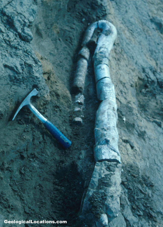
A spectacular specimen of Diplomoceras was found last year - a specimen that was 1.5 meters long (but curved; uncurved, it would be 14 feet long). The animal itself was ~6 feet long (a 6 feet long living chamber). Smaller pieces of this fossil are relatively common, but this specimen was unusually preserved. It is the nicest, most remarkable specimen known. (www.geologicallocations.com/assets/photos/antarctica/Seym...)
Seymour Island is very muddy to work on - it is always above freezing during the field seasons.
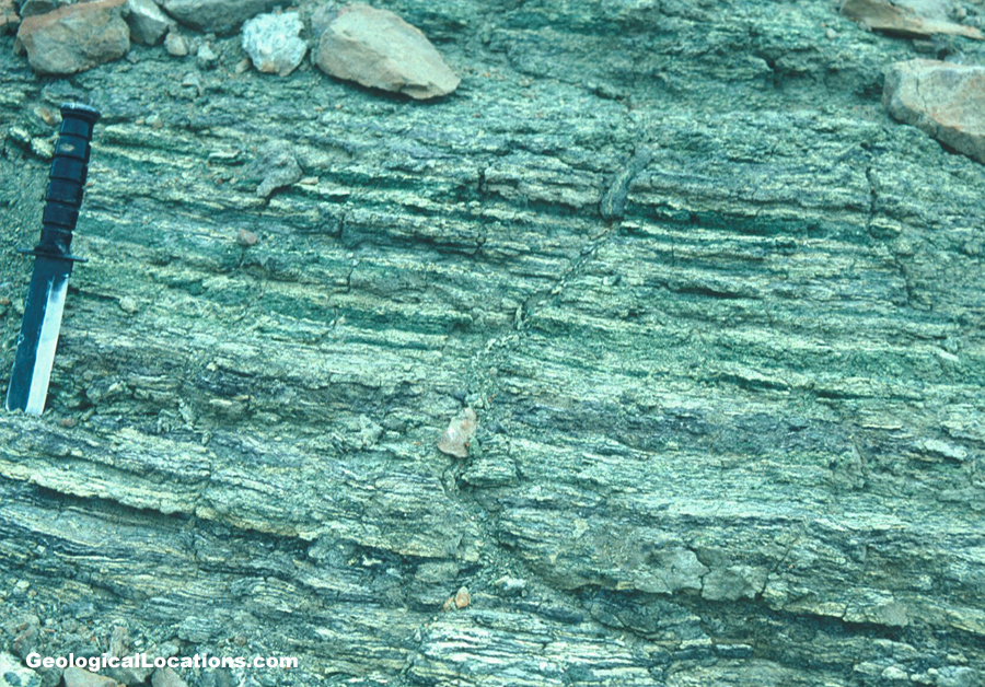
An iridium anomaly does occur here on Seymour Island. It occurs in a unit referred to as the K-T glauconite, which is a greenish, glauconitic sandstone that occurs at the boundary. The glauconitic sandstone is easily correlatable across the island. (www.geologicallocations.com/assets/photos/antarctica/Seym...)
There are no stratigraphic or sedimentological signatures at the K-T boundary within the glauconitic sandstone interval. There is no boundary clay, as classically seen at Gubbio, Italy.
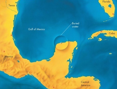
Antarctica is ~8000 miles away from the Chicxulub Crater in Yucatan, Mexico, which is a significant point as far as considering the after-effects expected to be seen in Antarctica. (www.theyucatantimes.com/wp-content/uploads/2014/06/Chicxu...)
Rudist record - there is a gradual increase in the diversity of rudist bivalves in the Cretaceous. (www.paleotax.de/rudists/intro-Dateien/image002.jpg) Most rudists went extinct at 67.5 to 68 million years ago (~early-late Maastrichtian boundary). This pattern mirrors other groups’ diversity patterns as well - all mostly go extinct before the K-T boundary.
Seymour Island ammonites crash at the end of the Campanian. Seymour Island inoceramid bivalves are gone near the end of the Campanian. (www.flickr.com/photos/jsjgeology/19921135882) Seymour Island belemnites virtually disappear at the end of the Campanian. Seymour Island ammonites are quite diverse in the Campanian (35-36 species), but their diversity crashes to 10 species in the Maastrichtian (= latest Cretaceous), and they are gone at the K-T boundary. Several Campanian cosmopolitan ammonite families disappear in the Campanian in the Seymour Island area, but they extend to the K-T boundary in lower latitudes. So, their disappearance in the Seymour Island area indicates a general temperature decline (cooling).
A regression occurred at the mid-Maastrichtian.
Superimposed on the Maastrichtian temperature decline are several rapid warming spikes. 50,000 years before the K-T boundary event was a warming event, documented from some ODP sites.
Note the restricted occurrence to 1 horizon on Seymour Island of the ammonite Zealandites varuna in the Maastrichtian Lopez de Bertodano Formation. Its presence probably represents a warming spike.
The faunal transition across the K-T boundary on Seymour Island - no single extinction event seen - a gradual decline is seen instead. There is no marked extinction horizon.
Then, someone suggested that this pattern is due to the Signor/Lipps Effect, a phenomenon produced by collection/preservation biases. One can get a gradual extinction pattern purely due to collecting and preservation biases. So, Zinsmeister and others recollected the fossils on Seymour Island, and collected fossils spatially, doing detailed mapping.
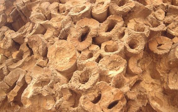
The K-T glauconite (~5 meters thick) is actually 3 units - a lower glauconite, a middle fish bed/horizon, and an upper glauconite. The fish debris bed could represent a victim bed from the K-T impact.
Renewed fossil collecting has resulted in a new diversity record - the extinction is less gradual now - it is more abrupt, but all groups are dying out just before the iridium anomaly. The K-T extinction is now more abrupt is high southern latitudes than previously thought.
Fish horizon - interpreted to be the effect of extreme ocean disruption; fish kills are not due to ocean poisoning (strangelove ocean), but by pulses of nutrients into the oceans. This is the only fish horizon in 1600 meters of section. It could be an interval of slow deposition, but this is not likely because fish degrade relatively quickly, and one needs special conditions to preserve fish. The fish debris bed represents conditions after the K-T event - lots of fish kills occurred.
The biosphere is far more robust than we give it credit for. Organisms have been able to survive truly catastrophic events in geologic history.
Example: the Millbrig Bentonite (Middle Ordovician, eastern USA and Scandinavia). This large volcanic eruption resulted in no extinctions. Therefore, Earth’s biosphere is very robust. But, if the biosphere is already stressed, then a big event can push the biosphere into a mass extinction.
------------------
These shells went extinct 1500 years ago as a result of a fantastic tectonic move that lifted the sea bed several tens of meters.
Wicker Park Warlords from a time before the hood flipped affluent; found this acting on a tip from "Mr. Eastvill". Between Schiller & Evergreen on Damen. (Gang Graffiti)
I noticed a few mountains were really volcanoes in Oahu. It's obvious since Hawaii was made because lavas were spewing out thousands of years ago from volcanoes and those lavas cooled off and became Hawaii. I heard in 200,000 years there will be new chains of islands in this region :o)
Eskimo Curlew (Numenius borealis). Extinct shorebird which once populated Canada and the U.S.
Probably the first bird Columbus saw when he discovered America. 2 million birds per year were killed in the 19th century. The last confirmed sightings were on Barbados in 1963. Specimen from the Zoological Museum in Firenze, Italy.
Bollockornis, now extinct, was a giant flightless bird, arguably related to todays ducks and geese. It had carnivorous habits and stood 2.5m high roaming Australia in a wetter climate than today during the middle Miocene period, 15 Million years ago.
Bollockornis planei was one of the heaviest birds to walk the earth with its powerful legs and small wings- a bit like todays smaller Emus and Cassowaries it only lived in Australia.
I captured this shot at the BWI observation park. It won't be long before all the AirTran 737 jets are re-painted with the colors of Southwest Airlines as the two airlines complete their merger.
Baltimore | Maryland | Baltimore/Washington International Thurgood Marshall Airport | Thomas A. Dixon, Jr. Aircraft Observation Area
Thanks for looking. I appreciate feedback!
1893 Stained glass window by Clayton & Bell, in memory of Granville Leveson Proby 4th Earl of Carysfort 1825-1872 - window erected by his brother and successor William 5th Earl of Carysfort
Granville & William were the 2nd & 4th sons of Admiral Granville Proby, 3rd Earl of Carysfort and Isabella daughter of the hon Hugh Howard
Granville m 1853 Lady Augusta Maria ++ daughter of William Hare, 2nd Earl of Listowel. Dying childless in Florence, he was succeeded by his brother
William Proby, 5th Earl of Carysfort 1836-1909 was 4th son of Admiral Granville Proby, 3rd Earl of Carysfort and Isabella née Howard who died after his birth. He m 1860 Charlotte Mary 1918 daughter of Rev Robert Boothby Heathcote. He also died childless when all their titles became extinct.
Their heir Col. Douglas James Hamilton www.flickr.com/gp/52219527@N00/6F719n son of their sister Elizabeth Emma Proby wife of Lord Claud Hamilton, changed his name in 1904 from Hamilton to Proby by royal license
++ Augusta has a window in her memory here www.flickr.com/gp/52219527@N00/gXaKo4 ) - Church of All Saints, Elton Huntingdonshire
Extinct monsters and creatures of other days : a popular account of some of the larger forms of ancient animal life / by Rev. H. N. Hutchinson. With illustrations by J. Smit, Alice B. Woodward, J. Green, Charles Knight, and others.
London : Chapman & Hall, 1910.
Ellipsocephalus hoffii Schlotheim, 1823 - internal molds of fossil trilobites in silty mudshale from the Cambrian of Bohemia.
Trilobites are extinct marine arthropods. They first appear in Lower Cambrian rocks and the entire group went extinct at the end of the Permian. Trilobites had a calcitic exoskeleton and nonmineralizing parts underneath (legs, gills, gut, etc.). The calcite skeleton is most commonly preserved in the fossil record, although soft-part preservation is known in some trilobites (Examples: Burgess Shale and Hunsruck Slate). Trilobites had a head (cephalon), a body of many segments (thorax), and a tail (pygidium). Molts and carcasses usually fell apart quickly - most trilobite fossils are isolated parts of the head (cranidium and free cheeks), individual thoracic segments, or isolated pygidia. The name "trilobite" was introduced in 1771 by Johann Ernst Immanuel Walch and refers to the tripartite division of the trilobite body - it has a central axial lobe that runs longitudinally from the head to the tail, plus two side lobes (pleural lobes).
The Middle Cambrian Jince Formation (pronounced “In-say”) of Bohemia is famous for its fossiliferous intervals that contain well-preserved trilobites. The Jince Formation’s trilobites have been documented in the literature since the 1700s. One of the more common species is Ellipsocephalus hoffii, first described and illustrated in 1823 by Ernst Friedrich Baron von Schlotheim as Trilobites Hoffii. It’s a rather plain-looking trilobite with a moderately effaced cephalon. Complete exoskeletons of this trilobite are abundant in certain intervals of the Jince Fm. The trilobite specimens seen here are preserved as internal molds, often heavily stained with yellowish limonite, in silty mudshale.
Classification: Animalia, Arthropoda, Trilobita, Polymerida, Ellipsocephalidae
Stratigraphy: Ellipsocephalus hoffii zone (= lower Hydrocephalus lyelli zone), upper Jince Formation, upper Middle Cambrian [Note: Hydrocephalus lyelli was considered a subjective junior synonym of Hydrocephalus rotundatus by Kordule (1990)]
Locality: unrecorded locality at or near the town of Jince, Stredocesky Region, Bohemia, Czech Republic
-----------
References cited & sources of additional info.:
Kordule, V. 1990. Rejkocephalus, a new paradoxid genus from the Middle Cambrian of Bohemia (Trilobita). Vestnik Ustredniho Ustavu Geologickeho 65: 55-60, 2 pls.
Schlotheim, E.F. 1823. Nachträge zur Petrefactenkunde, Zweyte Abtheilung. Gotha. 114 pp. 37 pls. [Trilobites Hoffii is described on pp. 30-31, 34, 85 & illustrated on pl. 22, figs. 2a, 2b.]
Šnajdr, M. 1958. Trilobiti českého středního kambria. Rozpravy Ústředního Ústavu Geologického 24. 280 pp. 46 pls. [Ellipsocephalus hoffii is described on pp. 88-92 & illustrated on pl. 7, figs. 1-8, pl. 8, figs. 1-7.]
Šnajdr, M. 1990. Bohemian Trilobites. Prague. Geological Survey. 265 pp. [Ellipsocephalus hoffii is described & illustrated on pp. 88-89]
Approximately 12,000 years ago, the land within the Tularosa Basin featured large lakes, streams, grasslands, and Ice Age mammals. As the climate warmed, rain and snowmelt dissolved gypsum from the surrounding mountains and carried it into the basin. Further warming and drying caused the lakes to evaporate and form selenite crystals. Strong winds then broke up crystals and transported them eastward. A similar process continues to produce gypsum sand today.[8]
Thousands of species of animal inhabit the park, a large portion of which are invertebrates. Several animal species feature a white or off-white coloration. At least 45 species are endemic, living only in this park, with 40 of them being moth species. The Tularosa Basin has also seen a number of human inhabitants, from Paleo-Indians 12,000 years ago to modern farmers, ranchers, and miners.
White Sands National Park was originally designated White Sands National Monument on January 18, 1933, by President Herbert Hoover. Since 1941, the park is completely surrounded by the military installations of White Sands Missile Range and Holloman Air Force Base. It was redesignated as a national park by Congress and signed into law by President Donald Trump on December 20, 2019. It is the most visited NPS site in New Mexico, with about 600,000 visitors each year.[9] The park features a drive from the visitor center to the heart of the dunes, picnic areas, backcountry campground in the dunefield, marked hiking trails, and sledding on the dunes. Ranger-guided orientation and nature walks occur at various times and months throughout the year. Wikipedia The potentially oldest known human footprints in North America were found at White Sands by researchers who identified approximately 60 fossilized footprints buried in layers of gypsum soil on a large playa in the Tularosa Basin.[10] Multiple human footprints are stratigraphically constrained and bracketed by layers containing seeds of Ruppia cirrhosa that yield calibrated radiocarbon ages between 23 and 21,000 years ago, according to the U.S. Geological Survey. The present consensus for human arrival into North America is placed at 13-16,000 years ago.[11][12] However, these estimates have been questioned by other authors, who suggest that the dating could potentially be erroneus, due to the fact that Ruppia cirrhosa intakes carbon from the water in which it grows rather than the air, which may introduce systematic error making the seeds seem older than they actually are.[13] However, the date was later supported by radiocarbon dating of pollen and optically stimulated luminescence dating of quartz grains within the footprint layers.[14] Other tracks are known for extinct megafauna, including ground sloths (likely either Nothrotheriops or Paramylodon) and Columbian mammoths, which appear to be contemporaneous to human footprints.[15]
Paleo-Indians inhabited the shoreline of Lake Otero, a large lake that covered much of the Tularosa Basin. They used stone from the mountains to create projectile points, known as Folsom and Plano points, and attached them to spears for hunting mammoths, camels, ground sloths, and bison. Projectile points and stone tools have been found in the basin associated with ancient shorelines, streams, and hills. As the large ice sheet that capped the North American continent receded, Lake Otero began to evaporate, leaving behind Alkali Flat and Lake Lucero. The grassland died and the basin became increasingly arid, slowly changing into desert scrubland. The megafauna disappeared from the basin leaving behind fossil footprints.[16]
The Archaic people improved upon the hand thrown spear used by Paleo-Indians with the invention of the atlatl. After Lake Otero dried out, wind carried large quantities of gypsum sand up from the basin floor which accumulated into a large dunefield. Archaic people entered the Tularosa Basin about 4,000 years ago, after the dunes had stabilized, possibly attracted by a cereal grass called Indian ricegrass. The first evidence of agriculture is found in the Archaic period. Archaic peoples would tend to wild plants so they would produce in a more reliable manner and in larger quantities than they did naturally. Archaic people started living in small villages throughout the year to tend their fields. Hearth mounds are found within the dunes, which are the remains of prehistoric fires containing charcoal and ash. When gypsum is heated to 300 °F (149 °C) it becomes a plaster that hardens when moisture is added and subsequently evaporates. The plaster cements these hearths in place, preserving them for thousands of years.[17]
The Jornada Mogollon people made pottery, lived in permanent houses, and farmed the Tularosa Basin. Evidence of their prehistoric presence dates back to about 200 CE. The Jornada Mogollon inhabited the basin until about 1350 CE when they moved away, leaving behind puddled adobe structures and pottery sherds.[18]
Two Mescalero Apache women and teepees, c. 1890–1910
Over 700 years ago, bands of Apaches followed herds of bison from the Great Plains to the Tularosa Basin.[18] The Apaches were nomadic hunters and gatherers who lived in temporary houses known as wickiups and teepees. The Apaches had established a sizable territory in southern New Mexico by the time European explorers arrived. They fiercely defended the rights to their homeland against the encroachment of colonial settlers. Apache groups, led by Victorio and Geronimo, fought with settlers in the basin and engaged in military battles with Buffalo Soldiers. The Battle of Hembrillo Basin in 1880 was a military engagement between Victorio's warriors and the United States Army's 9th Cavalry Regiment of Buffalo Soldiers. The battleground, located on White Sands Missile Range, is the closest archaeological evidence of the Apache Wars (1849 to 1924). Conflict between the Apaches and the American settlers over their conflicting interests in the basin ultimately ended in the forceful removal of the Apaches from their homelands to the Mescalero Apache Indian Reservation. The Mescalero Apache maintain an active cultural affinity to the landscape of their ancestors.[19]
Euro-Americans
edit
While a Spanish colony was established to the north around Santa Fe, the Tularosa Basin was generally avoided until the nineteenth century. The basin lacked any reliable water sources and was the primary stronghold of local Apaches who stole livestock from Pueblo and Spanish settlements near the basin. When Spaniards did enter the basin, they traveled along established trails to the salt pan north of Alkali Flat.[20] Spanish colonists had established the salt trails in 1647, to connect the salt deposits with the Camino Real in El Paso del Norte (present-day Ciudad Juárez) and silver mines in Durango, Mexico. Salt is a fundamental element in the processing of silver ore. Expeditionary parties using mule-drawn carts with military escorts would be formed a few times each year for the journey to the salinas (salt pans).[21]
Hispanic populations throughout the Spanish colonial and Mexican periods were allowed to gather salt from the salinas, which were considered public property. Texan-American settlers made private claims to the land to profit from mining of minerals on their property. James Magoffin held a title to the salt flats north of Lake Lucero but had been unsuccessful in collecting fees for salt gathering. In 1854, using military force, he intercepted a salt gathering expedition of Hispanos from Doña Ana at the salt flats and fatally wounded three members of the party. In response to Magoffin's use of extreme force during the Magoffin Salt War, the courts dissolved his property claim to the salt flats and established a precedent for free public access to salt deposits.[21]
The first US Army exploration of south-central New Mexico was led by a party of topographical engineering officers in 1849. They passed west of the San Andres Mountains and Organ Mountains. A lieutenant was dispatched east across the basin with a scouting party to map a potential military wagon route to the Sierra Blanca.[22]: 6
Hispanic families started farming communities at Tularosa in 1861 and La Luz in 1863. The villagers mixed water with gypsum sand from the dunefield to create plaster for the adobe walls of their homes. The white color was not only decorative but functional in deflecting the rays of the summer sun.[22]: 6
Lake Lucero, an ephemeral lake filled by a significant rainfall
In the 1880s, a brief period of heavy rainfall supported the return of lush grasslands in the Tularosa Basin which attracted the attention of goat, sheep, and cattle grazers, predominately from Texas. Large cattle drives pushed into the basin, and ranching became the dominant economy for the next sixty years. In 1897, the Lucero brothers, Jose, Felipe, and Estevan, began ranching on the south shore of the lake that would eventually bear their name. By 1940, Felipe consolidated the family's ranches into a 20,000-acre (31 sq mi; 81 km2) property. Shortly afterward, the National Park Service took over ownership of the Lucero family properties with their appropriation of Lake Lucero and Alkali Flat. The remnants of the Lucero family ranch include the stock pens, watering trough, a water well, and a fallen windmill which visitors can see on a ranger-led tour to Lake Lucero once each month, in the cooler months of the year.[23]
At the turn of the twentieth century, the discovery of oil, coal, silver, gold, and other precious mineral deposits inspired many settlers to cover the Tularosa Basin in mining claims. By 1904, over 114 people made mineral claims to more than 10,400 acres (16.3 sq mi; 42 km2) of Lake Lucero; however, very few of the claims were developed. Eddy's Soda Prospect, developed by the same Eddy brothers that had founded the El Paso and Northeastern Railway and the town of Alamogordo, was a mineral recovery operation for glauberite salt mining along the southern shore of Lake Lucero. In 1907, J.R. Milner and Bill Fetz constructed a plaster of Paris batching plant along the southern edge of the dunes. The operation involved drilling long shafts into the dunes and extracting gypsum to cook into plaster at night. Though successful, the establishment of the national monumental monument is the only permanently shut down the plant.[24] The idea of creating a national park to protect the white sands formation dates to 1898 when a group from El Paso, Texas, proposed the creation of Mescalero National Park. The plan failed as it included a game hunting preserve that conflicted with the idea of preservation held by the Department of the Interior.[22]: 17 [25]: 52–53
From 1912 to 1922, Albert B. Fall, a Senator from New Mexico—later appointed Secretary of the Interior—and the owner of a large ranch in Three Rivers northeast of the dune field, promoted four separate bills in Congress for a national park in the Tularosa Basin. Fall's ultimate plan was called the All-Year National Park as it would be open throughout the year, unlike more northerly parks. The bill included four geographically separate and diverse areas, to be administered as one national park. The proposed areas included a 2,000-acre (3.1 sq mi; 8.1 km2) scenic portion of the Mescalero Indian reservation, 640 acres (1.0 sq mi; 2.6 km2) of the dune field, 640 acres of a volcanic area to the north named Carrizozo Malpais, and the shoreline of the Elephant Butte Reservoir to the west, beyond the San Andres Mountains. Stephen Mather, the director of the National Park Service, criticized the proposal as having "disjointed boundaries, lack of spectacular scenery, and questionable usage." The National Parks Association and the Indian Rights Association campaigned against Fall's bill, mainly because of the appropriation of Indian reservation land and that it might establish a precedent of industrial usage within parks. The bill failed in Congress, and Fall resigned in 1923 during the Teapot Dome scandal.[22]: 22–28 [25]: 61–70
During the 1920s, an Alamogordo businessman named Tom Charles promoted the potential economic benefits of protecting the white sands formation. Charles mobilized enough local support for the construction of an improved state route between Las Cruces and Alamogordo (now U.S. Route 70), passing the southern edge of the dune field. He lobbied to have the dunes declared a national park but was advised by Senator Bronson M. Cutting, who had influence with President Herbert Hoover, that national monument status would be much easier to obtain.[22]: 28–32 [25]: 77–89
On January 18, 1933, President Hoover designated White Sands National Monument, acting under the authority of the Antiquities Act of 1906.[22]: 33 [26] The dedication and grand opening was on April 29, 1934.[25]: 102 Tom Charles became the first custodian of the monument,[22]: 35 [25]: 99 and the first concessionaire in 1939, operating as White Sands Service Company.[22]: 72 [25]: 117
The visitor center and a nearby comfort station, three ranger residences, as well as three maintenance buildings were constructed of adobe bricks as a Works Progress Administration project starting in 1936 and completed in 1938.[27][28] The original eight adobe buildings and other nearby structures were designated the White Sands National Monument Historic District when they were added to the National Register of Historic Places in 1988. The principal architects were Lyle E. Bennett and Robert W. Albers, who also designed NPS buildings together at Casa Grande and Bandelier national monuments.[29] Bennett also designed the picnic table shelters at White Sands, the Painted Desert Inn at Petrified Forest, and buildings at Carlsbad Caverns and Mesa Verde national parks.[28]
F-117s flying over White Sands to a retirement ceremony in Ohio. Holloman Air Force Base was its home base from 1992 to 2008.[30]
The park is completely surrounded by the military installations of White Sands Missile Range and Holloman Air Force Base, and has always had an uneasy relationship with the military.[25]: 131, 175 The missile range and air force base were established after the bombing of Pearl Harbor in 1941, with continuing operations after World War II and throughout the Cold War.[31] Errant missiles often fell within the park's boundaries, occasionally destroying some of the visitor areas.[22]: 145 Overflights from Holloman disturbed the tranquility of the area.[25]: 149 Flight training missions continue over the dunefield,[31] and the park closes temporarily for several hours during missile tests in the adjacent range and cooperative use area on the west side of the park.[32]
Between 1969 and 1977, 95 oryx were released on the missile range and adjacent areas of the Tularosa Basin by the New Mexico Department of Game and Fish for hunting purposes. The oryx, having no natural predators, entered the park and competed with native species for forage.[22]: 172 Thousands of oryx reside on the missile range presently, though annual hunts have occurred since 1974 to help control and stabilize the population. The National Park Service, concerned about the negative effects on native plants and animals within the park, erected a 67-mile (108 km) long boundary fence in 1996 to prevent oryx from entering.[33]
Increasingly problematic alcohol abuse by students on spring break in the 1990s led to a ban on the consumption of alcohol.[34] The possession of alcohol or alcohol containers is banned throughout the park from February 1 to May 31.[35]
World Heritage Site controversy
edit
White Sands was placed on a tentative list of potential World Heritage Sites on January 22, 2008.[36] The state's two U.S. Senators, Pete Domenici and Jeff Bingaman, wrote letters of support of the application.[37] U.S. Representative Steve Pearce declined to support the application, saying, "I would guarantee that if White Sands Monument receives this designation, that there will at some point be international pressures exerted that could stop military operations as we know them today."[38]
The WHS application generated much controversy in Otero County, most of it taking place in meetings of the Otero County Commission. A petition with 1,200 signatures opposing the application was presented to the commission on August 16, 2007.[39] The commission passed a resolution of opposition to the application on August 23, 2007,[40] and passed Ordinance 07-05 on October 18, 2007, relating to any potential World Heritage Site designations within the county. The ordinance requires coordination with the county in following its environmental planning and review process through its Public Land Use Advisory Council, and states that "No world heritage site...will be located on or adjacent to any military land...within or adjacent to the boundaries of Otero County."[41] On January 24, 2008, after the WHS tentative list was announced, the commission instructed the county attorney to write a letter to the Secretary of the Interior, demanding that WSNM be taken off the list.[42]
National park bill
edit
In May 2018, U.S. Senator Martin Heinrich (Democrat, New Mexico) introduced a bill to designate White Sands a national park.[43] Heinrich consulted with monument officials, the National Park Service, White Sands Missile Range, the U.S. Army and Holloman Air Force Base before the bill was introduced in Congress. The bill was supported by the Alamogordo City Commission; the Las Cruces City Council; the Mescalero Apache Tribal Council; the Town of Mesilla Board of Trustees; Alamogordo Mayor Richard Boss; New Mexico Senator Ron Griggs (Republican); the Alamogordo Chamber of Commerce; the Greater Las Cruces Chamber of Commerce; the Las Cruces Green Chamber of Commerce; the National Parks Conservation Association and the Southern New Mexico Public Lands Alliance. The bill was opposed, however, by Otero County commissioners, who stated that the main argument in favor of national park status was the potential for increased visitation, while also noting that the monument is already the most-visited NPS site in the state. The commissioners were also concerned that "the change in status will affect filmmaking here either from higher fees or increased regulation." The commissioners only supported boundary adjustments and additional infrastructure, such as campgrounds and improved road access.[44] The Doña Ana County commissioners also opposed the redesignation of White Sands as a national park.[45]: 5 The redesignation bill was re-introduced on March 27, 2019.[46][47]
On December 11, 2019, the U.S. House of Representatives passed the National Defense Authorization Act for Fiscal Year 2020, which includes legislation redesignating White Sands National Monument as White Sands National Park.[48] The Senate passed the act on December 16 and President Donald Trump signed the bill on December 20. The act includes the transfer of land management both to and from the missile range, as well as the protection of additional land, adding a net 2,029 acres (3.2 sq mi; 8.2 km2) to the park.[4][49]
A large extinct volcanic basalt column dominates the landscape in the north west of Tasmania, right next to the township of Stanley. The column abruptly rises 150 metres on the shore of the Bass Strait, but the top of the column is a flat plateau, where you can walk amongst the ancient grasslands and forests - ou are basically walking on an old solidified lava lake. This photo was taken shortly after sunrise along the main track that loops around the top of the Nut.
Sadly I was told by the owner of these butterflies that the two that he is pointing to are now extinct. They came from Germany and their habitat was destroyed during WW2 to make room for crops. Glen said that a friend had collected these before the excavations.
Superdomain: Neomura
Domain: Eukaryota
(unranked): Unikonta
(unranked): Obazoa
(unranked): Opisthokonta
(unranked) Holozoa
(unranked) Filozoa
Kingdom: Animalia
Subkingdom: Eumetazoa
(unranked): Bilateria
(unranked): Protostomia
Superphylum: Lophotrochozoa
Phylum: Mollusca
Class: Bivalvia
Subclass: Pteriomorphia
Order: Pectinida
Suborder: Pectinina
Superfamily: Pectinoidea
Family: †Neitheidae
Genus: †Neithea
Species: †N. striatocostata
Flickr → If you want the HD file of this photo, contact
sip-images-production@orange.fr
___________________________________________________
Pour une visualisation d’une page galerie, placez la souris sur le bouton en haut à gauche de la fenêtre flickr www.flickr.com/photos/sebastienduhamel/50395577481/in/pho...
___________________________________________________
Reportages “Mobilisations pour le Climat” www.flickr.com/photos/sebastienduhamel/collections/721576...
Reportages “Mouvements des Gilets jaunes” www.flickr.com/photos/sebastienduhamel/collections/721577...
Reportages Politiques www.flickr.com/photos/sebastienduhamel/collections/721576...
[NB] Dans cette base flickr, les photos sont d’une résolution de 1000x667px.
Pour une visualisation optimale d’une page d’album, placez la souris sur le bouton du centre en haut à droite de la fenêtre flickr, puis cliquez sur le bouton.
Pour une visualisation pleine écran cliquez sur la photo et flèches de direction du clavier.
____________________________________________________
Extinction Rebellion fr.wikipedia.org/wiki/Extinction_Rebellion
Le mouvement des Gilets jaunes fr.wikipedia.org/wiki/Mouvement_des_Gilets_jaunes
____________________________________________________
Photographie de Sébastien Duhamel www.sebastien-duhamel.com
Galerie www.flickr.com/photos/sebastienduhamel
Classeur www.flickr.com/photos/sebastienduhamel/collections
Album www.flickr.com/photos/sebastienduhamel/sets
____________________________________________________
[NB] Vous souhaitez partager cette photo sur vos réseaux ?
Copier-coller l'URL depuis la barre d'adresse.
This is one of the last Carolina Parrakeets (Conurus carolinensis) to have existed. It is on display at the Cincinnati Zoo. The species has been extinct since 1917.
We met this gentleman while walking back from the Mahon Falls. He has had this barn owl since it was about three days owl and the bird is very tame. He bring the owl to the mountains so it can hunt away from any danger of catching prey who have been poisoned. It appears the owls are almost extinct in Ireland because their natural food source, mice and rats are being poisoned to such an extent the poison is being transmitted to the owls and other birds of prey.
Snared, poisoned, trapped and shot, deprived of their natural habitat and weakened by disease, by 1910 they were rare and the annihilation was complete when the last captured Thylacine at the Hobart zoo died in 1936. Maybe?
Superdomain: Neomura
Domain: Eukaryota
(unranked): Unikonta
(unranked): Obazoa
(unranked): Opisthokonta
(unranked) Holozoa
(unranked) Filozoa
Kingdom: Animalia
Subkingdom: Eumetazoa
Clade: ParaHoxozoa
Clade: Bilateria
Clade: Nephrozoa
Superphylum: Deuterostomia
Phylum: Chordata
Clade: Olfactores
Subphylum: Vertebrata
Infraphylum: Gnathostomata
Clade: Eugnathostomata
Class: Chondrichthyes
Subclass: Elasmobranchii
Infraclass: Euselachii
Superorder: Galeomorphii
Order: Lamniformes
Family: Mitsukurinidae
Genus: Mitsukurina
Species: M. lineata†
Superdomain: Neomura
Domain: Eukaryota
(unranked): Unikonta
(unranked): Obazoa
(unranked): Opisthokonta
(unranked) Holozoa
(unranked) Filozoa
Kingdom: Animalia
Subkingdom: Eumetazoa
Clade: ParaHoxozoa
Clade: Bilateria
Clade: Nephrozoa
Superphylum: Deuterostomia
Phylum: Chordata
Clade: Olfactores
Subphylum: Vertebrata
Infraphylum: Gnathostomata
Clade: Eugnathostomata
Class: Chondrichthyes
Subclass: Elasmobranchii
Infraclass: Euselachii
Superorder: Squalomorphii
Order: Hexanchiformes
Family: Hexanchidae
Genus: Hexanchus
Species: H. agassizi†
Superdomain: Neomura
Domain: Eukaryota
(unranked): Unikonta
(unranked): Obazoa
(unranked): Opisthokonta
(unranked) Holozoa
(unranked) Filozoa
Kingdom: Animalia
Subkingdom: Eumetazoa
Clade: ParaHoxozoa
Clade: Bilateria
Clade: Nephrozoa
Superphylum: Deuterostomia
Phylum: Chordata
Clade: Olfactores
Subphylum: Vertebrata
Infraphylum: Gnathostomata
Clade: Eugnathostomata
Class: Chondrichthyes
Subclass: Elasmobranchii
Infraclass: Euselachii
Superorder: Galeomorphii
Order: Orectolobiformes
Family: Ginglymostomatidae
Genus: Nebrius
Species: N. bequaerti†
my first tasmanian tiger sighting! this guy is in a travelling exhibit called Extreme Mammals. I saw it at the Cleveland Museum of Natural History. He originally came from AMNH in new york, but I'm not sure where he is going after that.
Extinct volcano 6 miles (10 km) North of Williams, Arizona, on the road to Valle. Erosion has exposed the black volcanic cinder making up the mountain.
Almost all hills and mountains in the area north of Flagstaff, Arizona, to the Grand Canyon, are extinct volcanoes. This area has produced over 600 volcanoes over the last six million years or one every ten thousand years. The most recent erupted around 1064 AD.
This volcano is North of Williams, Arizona, about 30 miles (48 km) West of Flagstaff, Arizona.
She hangs so good its crazy. Im so happy with the way this piece turned out even though it is impossible to photograph. Hope some peeps can see it person in Seattle, Portland, and LA