View allAll Photos Tagged Describes
As promised under my last photograph, I thereby start the small series describing the Polish coal mainline.
First things first - what do we see on the picture?
ST44-1265 together with ST44-1256 are heading a heavy aggregate train to Gdańsk Osowa in some very unfavorable lighting conditions. The train is entering Kościerzyna after a short stop at the entry signal, providing a cool smoke show.
So now about the railway line. The Coal-Mainline of Poland is one of the greatest infrastructural undertakings of interwar period Poland. Not often do we get to see railway projects mentioned in our school history books, yet this one made it, which just goes to show how important it was.
There were a couple of reasons for building it, but there is one most important one.
Poland was a nation very rich in coal and it was one of the main exports (15 million tonnes a year) before the second world war. All thanks to the very developed region of Silesia, parts of which were aquired from the 3 occupiers of Poland throughout the 19th century. As one of the biggest coal mining regions in central Europe, it had a lot of significance and the coal had to be transported out to customers. This was often done with the help of cargo ships, which could sail across oceans and transport gigantic amounts of freight. Tthe largest harbour locally was Gdańsk, which got the status of Free City of Danzig. The semi-free government of the semi-free city state however put a lot of barriers on Polish exports and so the country had to find another way - construct a new, better and bigger harbour.
The location for it was chosen in Gdynia, a small fishing village 15 kilometers north of Danzig. Before the start of WW2, it had grown into a city of 130 thousand people with a big and prosperous harbour, which was to become the terminus of the numerous coal trains from the South. Here another problem emerged - all major railway routes leading to it, were passing through Danzig! There was only one way to solve this problem - bypassing the city via Kociewie and the very hilly (rolling hills formed by a glacier) historical region of Kashubia.
And so, the construction of the railway line started in 1928 on the South, with the first part of it connecting Herby Nowe and Inowrocław. There it connected to the already built railway line Inowrocław - Bydgoszcz, and from Bydgoszcz once again it went on through uncharted territory of the Tuchola woodlands - via Wierzchucin and Kościerzyna all the way to Gdynia.
At the end of 1930 the entire Northern and Southern sections of the line had been finished, but there were problems with the construction works and funding for the middle section. Consequently, normal traffic on the entire line from Silesia to Gdynia hadn't been started until 1937. The total length of the line reached just under 500km.
Before the start of WW2 countless pairs of freight trains from Silesia to Gdynia ran through what mostly was "no man's land". Because of that, running local passenger trains wasn't really viable, and so freight was prioritised, allowing for more throughput.
More posts about the line to come :)
Photo by Piotrek/Toprus
Powis Castle (Welsh: Castell Powys) is a medieval castle, fortress and grand country house near Welshpool, in Powys, Wales. The seat of the Herbert family, earls of Powis, the castle is known for its formal gardens and for its interiors, the former having been described as "the most important", and the latter "the most magnificent", in the country. The castle and gardens are under the care of the National Trust. Powis Castle is a Grade I listed building, while its gardens have their own Grade I listing on the Cadw/ICOMOS Register of Parks and Gardens of Special Historic Interest in Wales.
The present castle was built in the 13th century. Unusually for a castle on the Marches, it was constructed by a Welsh prince, Gruffydd ap Gwenwynwyn, rather than by a Norman baron. Gruffydd was prince of the ancient Kingdom of Powys and maintained an alliance with the English king Edward I during the struggles of the later 13th century. He was able to secure the position of his son, Owain, although the kingdom itself was abolished by the Parliament of Shrewsbury in 1283. After his father's death, Owain was raised to the peerage as Owen de la Pole, 1st Lord of Powis. Following his own death c. 1293, and the death of his only son, he was succeeded by his daughter, Hawys Gadarn, "the Lady of Powis". Hawys married Sir John Charlton in 1309.
In the late 16th century the castle was purchased by Sir Edward Herbert, a younger son of William Herbert, 1st earl of Pembroke, beginning a connection between the family and the castle that continues today. The Herberts remained Roman Catholic until the 18th century and, although rising in the peerage to earls, marquesses and Jacobite dukes of Powis, suffered periods of imprisonment and exile. Despite these setbacks, they were able in the late 17th and early 18th centuries to transform Powis from a border fortress into an aristocratic country house, and surround it with one of the very few extant examples of a British Baroque garden.
In 1784 Henrietta Herbert married Edward Clive, eldest son of Clive of India, a match which replenished the much-depleted Herbert family fortune. In the early 20th century, George Herbert, 4th Earl of Powis, redeveloped the castle with the assistance of the architect George Frederick Bodley. Herbert’s wife, Violet, undertook work of equal importance in the garden, seeking to turn it into "one of the most beautiful, if not the most beautiful, in England and Wales". On the 4th Earl's death in 1952, his wife and his sons having predeceased him, the castle passed into the care of the National Trust.
History
First castles at Welshpool: 1111–1286
Unlike the castles at Conwy, Caernarfon, Harlech and nearby Montgomery, which were built by the English to subdue the Welsh, the castles at Welshpool were built by the Welsh princes of Powys Wenwynwyn as their dynastic seat.[1] In addition to the current site, two motte-and-bailey castles and a set of earthworks are located nearby.[2] The names Trallwg/Tallwm and Pola are used interchangeably in early primary sources, and it is unclear which of these sites is being referred to.[3]
The earliest reference dates from 1111, when Cadwgan ap Bleddyn is mentioned as having planned to construct a castle at Trallwng Llywelyn,[3] the oldest record of a native Welsh castle.[4] Domen Castell, a motte-and-bailey near the modern railway station, is considered the most likely site of Cadwgan's castle, although it is uncertain whether it was completed as he was assassinated the same year.[5] The first documentary account of an extant castle at Welshpool is a description of the successful 1196 siege by an English army, although the castle was retaken by the Welsh within the year.[5][6]
The earliest castle at the current site may have been a timber building constructed by Owain Cyfeiliog or his son, Gwenwynwyn (r. 1197–1216).[7] The present masonry structure contains 13th-century fabric,[8] most likely the work of Gruffydd ap Gwenwynwyn (r. 1241–1287) – although historians are uncertain when this took place.[a][10] In 1274, Gruffydd's "first castle" at Welshpool was destroyed by Llywelyn ap Gruffudd as punishment for his involvement in a scheme to assassinate Llywelyn.[b] The castle was documented again in 1286, when it was listed amongst Gruffydd's possessions as "la Pole Castr".[12] A detailed examination of Powis Castle's extant masonry carried out between 1987 and 1989 revealed early stonework incorporated into the later structure, putatively the remains of an early stone shell keep.[13] At the end of Edward I's conquest of Wales in 1282–83, the king permitted Gruffydd to rebuild his castle at Welshpool as a reward for his loyalty.[14]
Early history: 1286–1644
Edward Herbert, 1st Baron Herbert of Cherbury[c]
In 1286, four years after the conquest of Wales, Gruffydd's son, Owain ap Gruffydd ap Gwenwynwyn became the last hereditary prince of Powys when he renounced his royal title, and was granted the barony of de la Pole, (i.e. "of the Pool", a reference to Welshpool, formerly called just "Pool").[d][16][17] The ancient Kingdom of Powys had once included the counties of Montgomeryshire, much of Denbighshire, parts of Radnorshire and large areas of Shropshire, but by the 13th century had been reduced to two independent principalities – Powys Wenwynwyn and Powys Fadog – roughly equivalent to Montgomeryshire and South Denbighshire (plus Maelor Saesneg), respectively; Welshpool had become the capital of Powys Wenwynwyn, of which Owain had been heir. On the death of Owain, the castle passed to his daughter Hawys, who married Sir John Charlton.[17] The Charltons continued to live at Powis until the fifteenth century when two daughters, Joyce Tiptoft and Joan Grey inherited the castle and estates. Both were equally divided, each daughter and her husband living in a portion of the castle.[18]
In 1578 an illegitimate son of the last Baron Grey of Powis, began leasing the lordship and castle to a distant relative – Sir Edward Herbert (d. 1595), second son of Sir William Herbert, 1st Earl of Pembroke. Edward eventually bought the castle outright in 1587, beginning the connection between the Herberts and Powis Castle which continues today.[19] Sir Edward's wife was a Roman Catholic and the family's allegiance to Rome and to the Stuart kings was to shape its destiny for over a century.[16] Sir Edward began the transformation of Powis from a border fortress into an Elizabethan country house. The major remaining element of his work is the Long Gallery.[19]
Herbert's descendent William Herbert, 1st Baron Powis (c. 1573–1655), was a supporter of Charles I, and was granted the barony of Powis in 1629.[19] His loyalty during the English Civil War cost him his castle and his estates.[20] On 22 October 1644 Powis Castle was captured by Parliamentary troops and was not returned to the family until the restoration of Charles II in 1660.[21]
The Herberts: 1660–1800
The Hercules statue which stood originally in the Water Garden
On the restoration, the Herberts returned to Powis, and in 1674 William Herbert (c. 1626–1696) was created Earl of Powis (of the first creation). The state bedroom was installed in about 1665 and further improvements, including the construction of the Great Staircase followed in the 1670s. These developments were most probably carried out under the direction of William Winde, who may also have designed the terraced gardens. His employer, although restored to his estates, and raised in the peerage, was barred by his Catholic faith from high office under Charles II. On the accession of the King's brother, James in 1685, Herbert became one of the new king's chief ministers, and was again advanced in the peerage becoming Marquess of Powis in 1687, but fell at the Glorious Revolution of 1688 and followed James into exile in France.[e] William III granted the castle to his nephew, William Nassau de Zuylestein, 1st Earl of Rochford. Herbert died, still in exile, in 1696.[24]
Despite their 30-year exile, the Herberts were able to continue with developments at the castle and even to live there on an irregular basis, the Baroque water garden below the castle being completed at this time.[25] Their fortunes were also materially improved by the discovery of a lucrative lead mine on their Welsh estates.[24] The second Marquess, also William, was reinstated in 1722. On the death of his son, the third Marquess in 1748, the marquessate became extinct, while the castle and estates passed to a relative, Henry Herbert (c. 1703–1772), of Oakly Park in Shropshire, who was made 1st Earl of Powis (of the second creation) by George II.[26] Herbert married Barbara, the fifteen-year-old granddaughter of the 2nd Marquess, in 1751. Their eldest son, George Herbert, 2nd Earl of Powis (1755–1801), died unmarried and the earldom of the second creation became extinct.[f][27] Powis was much neglected during his tenure. John Byng, 5th Viscount Torrington, a diarist and traveller who chronicled his journeys into Wales in the 1780s and 1790s, described the castle in 1784, "In the gardens not even the fruit is attended to; the balustrades and terraces are falling down, and the horses graze on the parterres!!!"[28] The castle itself was in no better condition, a visitor in 1774 describing it as "in Neglect and Ruin".[27] Nonetheless, the potential of the site was recognised. George Lyttelton, the politician, poet and essayist, recorded his impressions in 1756, "About £3,000 laid out upon Powis Castle would make it the most august place in the Kingdom."[29]
The Clives and Herberts: 1801–1952
The Outer Courtyard with the Fame statue in the foreground
In 1784, Henry Herbert's daughter, Henrietta, married Edward Clive (1754–1839), the eldest son of Clive of India.[30] Clive had followed his father to India, and served as Governor of Madras. Henrietta's brother died in 1801, whereupon the title lapsed; in 1804, her husband was created first Earl of Powis (of the third creation). The Clive fortune paid for long overdue repairs to the castle, which were carried out by Sir Robert Smirke.[31][32] Their son, Edward (1785–1848), inherited his late uncle's Powis estates on his 21st birthday, taking the surname Herbert in compliance with his uncle's will.[30] Edward Herbert served in a range of administrations as an Anti-Catholic Tory, his speeches in the House of Commons being "cautious and pertinent, although marred by dull delivery". He died in 1848, following a shooting accident at Powis in which he was fatally injured by his second son.[33] No further major changes were made to the Powis estate during his time, or in the long tenure of his eldest son Edward Herbert, 3rd Earl of Powis (1818–1891), although the castle was well maintained. In honour of his great-grandfather, the earl was offered the viceroyalty of India by Benjamin Disraeli but declined, writing "Not worth considering. Powis" on the envelope containing the invitation.[34]
The final alterations to Powis Castle were undertaken at the beginning of the 20th century by George Frederick Bodley for George Charles Herbert, 4th Earl of Powis (1862–1952). The rooms designed by Bodley remain his only extant decorative scheme; the longevity of the 4th Earl, the deaths of his heirs, and his bequest of the castle to the National Trust saw the early 20th-century remodelling remain largely unaltered.[g][36] The 4th earl's wife, Violet (nee Lane-Fox), undertook the final transformation of the gardens of Powis Castle, which she felt had the potential to be "the most beautiful in England and Wales".[37] The Countess died following a car accident in 1929, and Lord Powis outlived both his sons, who died on active service, Percy from wounds received at the Battle of the Somme in 1916,[38] and Mervyn in a plane crash in 1943.[39] On his own death in 1952, he bequeathed the castle and gardens to the National Trust.[h][42]
The National Trust: 1952–present
The 4th earl was succeeded by his cousin, Edward Herbert, 5th Earl of Powis (1889–1974). Edward's heir was Christian Herbert, 6th Earl of Powis (1904–1988). He was succeeded by his cousin, George Herbert, 7th Earl of Powis (1925–1993),[42] who was in turn succeeded by his son, John, the 8th and current Earl.[43] The Herbert family continue to live in part of the castle, under an arrangement with the National Trust.[44] The Trust has undertaken a number of major works of restoration during its ownership, including the Marquess Gate,[45] the Grand Staircase,[46] and the sculpture of Fame in the Outer Courtyard.[i][47] The castle and its gardens receive around 200,000 visitors annually. Wikipedia
Described as "pugnacious" and "boisterous". I find them a challenge to photograph as they disappear and reappear in the marsh reeds. Photographed on the Western Slope, Colorado.
Best described as extremely windy at this point and wet. I decided to get lower to the rocks and hide away from the high winds. Thankfully I felt safe lower down from the cliff edge. This is a cracking place and one I will return at another time when the weather isn't so tough for photography. The grey day really brought out the beautiful blue aqua colours in the sea.
Little did I know when I first set eyes on this wildflower that it would take over a decade to identify it. When I took the photo, I thought, "This will be easy. There are fewer flowers, especially blue or violet with four petals." Wrong! There are fewer, but it turns out there are 400,000 flowering species and "only" 230,000 have been described. I found this flower at the based of a trail on Mt. Diablo leading to Castle Rock Park.
Today, in one final gasp, I spent more than two hours going through my four books on wildflowers of the west (and Sierras and Central California), and came up with ... oh, what's that scientific term... ah, ZILCH! Nada, Nil. My life may be frustrating, but it's rarely dull.
I bit the bullet. I don't like to impose on a good acquaintance (less than a friend, but through an interest in nature, we have corresponded often), John Muir Laws by name. Jack holds the Nature Stewardship through Science, Education, and Art at the SF Academy of Sciences. More important, he's a naturalist, has written several books on wildlife of the Sierras etc., and teaches the art of painting wildlife. And so, as I do about once a year, I emailed him. Having explained that the closest I could come for this flower, was the Clarkia Elegance (see below) which is endemic to my mountain. His response: "I totally understand the confusion. It looks a lot like a Clarkia. Check out the purple version of Wild radish (Raphanus raphanistrum)."
And so Flickrites, this is the Wild Radish of the Mustard family!
The National Churches Trust describes St Mary's in Potterne as a “an Early English church of exceptional purity and austerity.”
A priest, and land held by the Bishop of Salisbury, was recorded at Potterne in Domesday Book of 1086, and in Victorian times, a 10th Century font was found on the site of the present day Church of England parish church of St Mary. It was built in the 13th century and has survived with little change, beyond work to the tower in the 15th century and restoration by Ewan Christian. Pevsner describes it as, “An Early English parish church of exceptional purity and indeed classicity” and linked this to the Bishops’ ownership of the manor.
The church is cruciform, with a substantial tower over the crossing, and original lancet windows. It is built of rubble stone, with ashlar to the upper tower. The south porch was added in the 14th century, and in the 15th the tower was made higher and given an elaborate battlement. Restoration in 1870–2 included re-roofing and the removal of galleries, and the stained glass is from various dates in that century.
From the 11th century, the church had been linked to All Saints at West Lavington as tithes from both churches endowed a prebendary at Salisbury Cathedral. From 1967 the benefice was held in plurality with Worton and since 2017 the parish has been part of the Wellsprings benefice, which extends to Seend, Bulkington and Poulshot.
Potterne is a village with a population of 1,544 (2021), 2 miles/3 km south of the Wiltshire market town of Devizes.
This description incorporates text from the English Wikipedia.
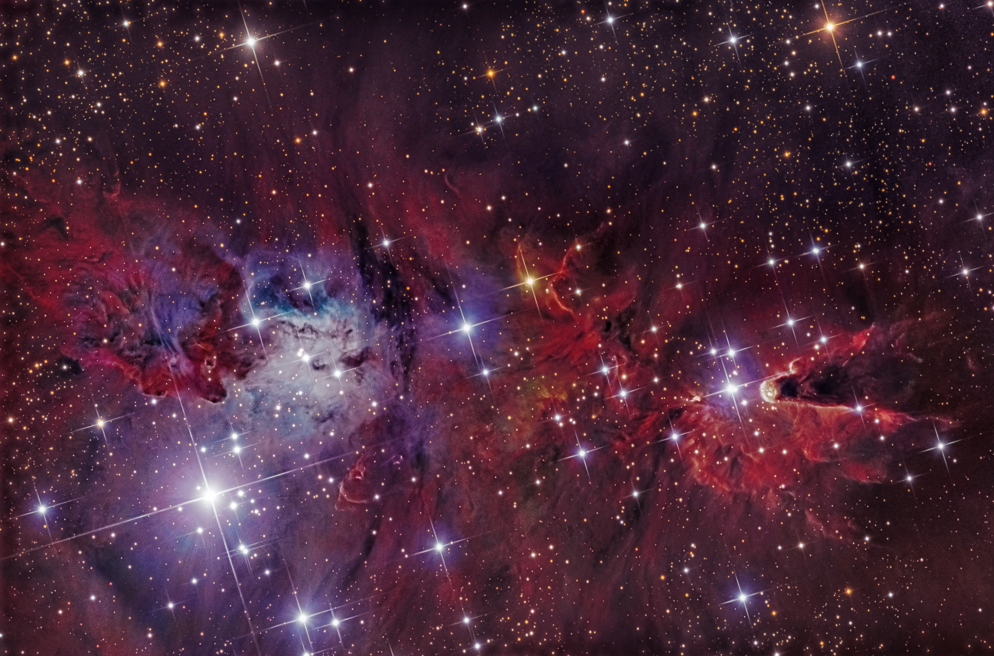
“NGC 2264 describes several objects in the constellation Monoceros lying about 2,700 light-years from Earth. One is the Christmas Tree star cluster, here lying on its side with the blazing bright star S Monocerotis marking its trunk at Lower left. There is a diffuse red nebula caused by H-alpha emissions from hydrogen gas stimulated by ultraviolet radiation emitted by S Monocertis and the cluster's other white-blue stars. There are two special star forming regions in the red nebula. At centre right, off the tip of the Christmas Tree, is the Cone Nebula, named for its apparent shape sculpted by fierce stellar winds emitted from the stars. It is a dark molecular cloud within which other new stars are forming. Numerous other sculpted swirls of nebulosity are nearby. At centre left is the Fox Fur Nebula, Sharpless 273, named for the rich textured appearance sculpted by stellar winds in that region. In contrast, the blue nebula is a reflection nebula caused by scattered blue light reflecting off residual dust in a region where stars have already formed” [adapted text, credit SkyandTelescope].
The image is made up of a Luminance - Hydrogen Alpha blend for the resolution, and then a low resolution, small set of Red, Green, and Blue forming the colour channel. You can see I push the data a little too hard to reveal the detail, so maybe one day in the future I can collect more luminance and Ha to perhaps achieve a smoother result. But for the time being, I’m quite happy with the result from new Pixinsight procedures learnt.
Thanks for having a look.
Hi Res version:
c2.staticflickr.com/2/1849/30241366108_6a24dd52b9_o.jpg
Information about the image:
Instrument: Planewave CDK 12.5 | Focal Ratio: F8
Camera: STXL-11002 + AOX | Mount: AP900GTO
Camera Sensitivity: Lum+Ha: Bin 1x1, Red, Green, Blue: Bin 2x2
Exposure Details: Lum: 32 x 900sec [8hrs], Ha: 31 x 1200 [8hrs] RGB: 450sec x 6 each [2.25hrs]
Viewing Location: Central Victoria, Australia.
Observatory: ScopeDome 3m
Date: January-February 2018
Software Enhancements: CCDStack2, CCDBand-Aid, PS, Pixinsight
Author: Steven Mohr
In my previous post I described my reason for being out this way and having arrived at Portage at 2015 I knew the Coastal would arrive soon. The sun was soon to be obscured by clouds so I decided to move a bit further south where the sun was still shining. I settled on this view of the train exiting the Placer River Valley with my view point towards the Portage Valley. I framed the shot with the Fireweed in full bloom and my luck held with the sun shining until after the train disappeared.
Describe yourself in four words.
Difficult, irrational, thoughtful, quiet.
Your most recent embarassing moment?
Uhm, I'm so clumsy that it's hard to pin point a particular moment...
Oh, the best one that is kinda recent is when I asked Robert (pilot) if planes have a horn. Yeh...
Never known someone laugh so hard!
Do you bottle things up or let them out?
I bottle things up. People who care about me often have to go through this huge process to get me to open up. I feel bad afterwards.
What makes you angry?
Arrogance. I hate egotistical people. They're generally ignorant at the same time and that doubles my anger. I love confidence but I wish everyone was nice along with it.
What was written in your school report?
"Katy is a very friendly girl"... I wish I was still so innocent and friendly. I'll admit that I'm still a very friendly person... manners cost nothing. But having met so many different people on a daily basis at work I have lost faith in the human race. It's often the elderly who are the rudest in all honesty.
If you could change one thing about yourself...
My lack of will power. I never stick with things. Diets are impossible for me.
What are you most proud of?
In myself? Uhm, the fact that I don't drink or smoke. I think that's an achievement in a binge-drinking nation. Being the daughter of an alcoholic man made me see sense.
Tectonic Asphalt Theory describes the small-scale movements of a road surface which causes it to drift apart over time.
So… that makes me wonder… if we wait long enough… will Smith street morph into West street… and will Adderly street one day lead us directly to Greenmarket Square!? Heh heh… I suspect NOT! :)
I still don’t have anything new to post… so I’m still scratching around in my archives… here’s hoping for a cloudy blue sky later this afternoon!!
Nikon D300, Sigma 18-200mm at 18mm, aperture of f11, with a 1/60th second exposure.
Click here to view this one large.
Click here to check out my Vertorama tutorial.
Too awesome to describe.
To give a sense of scale, we were in a 20-person raft floating around this 'Horseshoe Bend' of the Colorado river earlier in the day. The river is about 200 ft wide in this shot, and the center rock is about 700 ft tall.
2-frame vertically-shot panorama, Taken from a cliff about 1000 ft up from the river, belly-laying on the rock ledge, hanging the camera over to take this. Yes, it was scary!
To see the view on the river at water level, go here:
This object when described is often referred to as having a resemblance to a Bogeyman, and I have to agree! Looking like some kind of dark ominous shadow creature, standing poised in the night’s sky, with an arm raised ready to cast a hot fiery orb. But, LDN1622 is in fact not such dramatic object, being mostly an enormous lane of obscuring dust a front of a faint emission nebula that seems to form part of the massive Barnard’s Loop in the constellation of Orion. The fiery orb object is a reflection nebula, categorised as van den Bergh 62 [VDB62].
In compiling this image, I remained with the colour filters of Luminance, Red, Green and Blue; leaving out my collected Ha data set.
Hi resolution image:
c2.staticflickr.com/8/7832/47032903891_1e7323f58f_o.jpg
Information about the image:
Instrument: Planewave CDK 12.5 | Focal Ratio: F8
Camera: STXL-11000 + AOX | Mount: AP900GTO
Camera Sensitivity: Lum: BIN 1x1, RGB: BIN 2x2
Exposure Details: Total: 19.75 hours | Lum: 55 x 900 sec [13.75hr], RGB 450sec x 16 each [6.0hrs]
Viewing Location: Central Victoria, Australia.
Observatory: ScopeDome 3m
Date: March-April 2018, and December 2018-February 2019
Software Enhancements: CCDStack2, CCDBand-Aid, PS, Pixinsight
Author: Steven Mohr
For my friend NatuurfotoRien/Rien in Holland, who loves corvids.
I had this odd notion that when I retire I would carve a totem pole, and so over the years, I learned more and more about northwest coast art, culture, and carving. One of the pieces I studied was this - a huge cedar sculpture carved by the great sculptor, Bill Reid, to whom the telling of this ancient story is credited.
Bill Reid was a Haida indian (Haida is their word for “human”). The Haida tribe lives in the Queen Charlotte Islands off the coast of northern Canada (below Alaska), in a special place they call Haida Gwaii. Bill is widely credited for reviving the arts of the northwest coast - he was an amazing sculptor. I am disappointed I will never meet him.
The northwest coast tribes have many gods - all animals. Raven is the Haida equivalent of “fox”. Tricky, playful, smart, inquisitive - these are all qualities of Raven, whose play and trickery created the stars in the sky, the sun, the ocean and man.
The man-size (literally) sculpture is inside the University of British Columbia museum in Vancouver, Canada. When it was installed, Bill had the children of Haida Gwaii come to the installation - each with bottles of sand from the beach at Haida Gwaii, so Raven, could be installed in his native soil.
Here is his telling of their genesis myth - one of the most sacred stories in Haida culture:
The Story of the Raven Creating Man by Bill Reid
The great flood which had covered the earth for so long had receded, and even the thin strip of sand now called Rose Spit, stretching north from Naikun village lay dry. The Raven had flown there to gorge himself on the delicacies left by the receding water, so for once he wasn't hungry. But his other appetites - lust, curiosity and the unquenchable itch to meddle and provoke things, to play tricks on the world and its creatures - these remained unsatisfied.
He had recently stolen the light from the old man who kept it hidden in a box in his house in the middle of the darkness, and had scattered it throughout the sky. The new light spattered the night with stars and waxed and wane in the shape of the moon. And it dazzled the day with a single bright shining which lit up the long beach that curved from the spit beneath Raven's feet westward as far as Tao Hill. Pretty as it was, it looked lifeless and so to the Raven quite boring. He gave a great sigh, crossed his wings behind his back and walked along the sand, his shiny head cocked, his sharp eyes and ears alert for any unusual sight or sound. Then taking to the air, he called petulantly out to the empty sky. To his delight, he heard an answering cry - or to describe it more closely, a muffled squeak.
At first he saw nothing, but as he scanned the beach again, a white flash caught his eye, and when he landed he found at his feet, buried in the sand, a gigantic clamshell. When he looked more closely still, he saw that the shell was full of little creatures cowering in terror of his enormous shadow.
Well, here was something to break the monotony of his day. But nothing was going to happen as long as the tiny things stayed in the shell, and they certainly weren't coming out in their present terrified state. So the Raven leaned his great head close to the shell, and with the smooth trickster's tongue that had got him into and out of so many misadventures during his troubled and troublesome existence, he coaxed and cajoled and coerced the little creatures to come out and play in his wonderful, shiny new world. As you know the Raven speaks in two voices, one harsh and strident, and the other, which he used now, a seductive bell-like croon which seems to come from the depths of the sea, or out of the cave where the winds are born. It is an irresistible sound, one of the loveliest sounds in the world. So it wasn't long before one and then another of the little shell-dwellers timidly emerged. Some of them immediately scurried back when they saw the immensity of the sea and the sky, and the overwhelming blackness of the Raven. But eventually curiosity overcame caution and all of them had crept or scrambled out. Very strange creatures they were: two-legged like the Raven, but there the resemblance ended. They had no glossy feathers, no thrusting beak. Their skin was pale, and they were naked except for the long black hair on their round, flat-featured heads. Instead of strong wings, they had thin stick-like appendages that waved, and fluttered constantly. They were the original Haidas, the first humans.
For a long time the Raven amused himself with his new playthings, watching them as they explored their much expanded-world. Sometimes they helped one another in their new discoveries. Just as often, they squabbled over some novelty they found on the beach. And the Raven taught them some clever tricks, at which they proved remarkably adept. But the Raven's attention span was brief, and he grew tired of his small companions. For one thing, they were all males. He had looked up and down the beach for female creatures, hoping to make the game more interesting, but females were nowhere to be found. He was about to shove the now tired, demanding and quite annoying little creatures back into their shell and forget about them when suddenly - as happens so often with the Raven - he had an idea.
He picked up the men, and in spite of their struggles and cries of fright he put them on his broad back, where they hid themselves among his feathers. Then the Raven spread his wings and flew to North Island. the tide was low, and the rocks, as he had expected, were covered with those large but soft-lipped molluscs known as red chitons. The Raven shook himself gently, and the men slid down his back to the sand. The he flew to the rock and with his strong beak pried a chiton from its surface.
Now, if any of you have ever examined the underside of a chiton, you may begin to understand what the Raven had in his libidinous, devious mind. He threw back his head and flung the chiton at the nearest of the men. His aim was as unerring as only a great magician's can be, and the chiton found its mark in the delicate groin of the startled, shell-born creature. There the chiton attached itself firmly. Then as sudden as spray hitting the rocks from a breaking wave, a shower of chitons broke over the wide-eyed humans, as each of the open-mouthed shellfish flew inexorably to its target.
Nothing quite like this had ever happened to the men. They had never dreamed of such a thing during their long stay in the clamshell. They were astounded, embarrassed, confused by a rush of new emotions and sensations. They shuffled and squirmed, uncertain whether it was pleasure or pain they were experiencing. They threw themselves down on the beach, where a great storm seemed to break over them, followed just as suddenly by a profound calm. One by one the chitons dropped off. The men staggered to their feet and headed slowly down the beach, followed by the raucous laughter of the Raven, echoing all the way to the great island to the north which we now call Prince of Wales.
That first troop of male humans soon disappeared behind the nearest headland, passing out of the games of the Raven and the story of humankind. Whether they found their way back to the shell, or lived out their lives elsewhere, or perished in the strange environment in which they found themselves, nobody remembers, and perhaps nobody cares. They had played their roles and gone their way.
Meanwhile the chitons had made their way back to the rock, where they attached themselves as before. But they too had been changed. As high tide followed low and the great storms of winter gave way to the softer rains and warm sun of spring, the chitons grew and grew, many times larger than their kind had ever been before. Their jointed shells seemed about to fly apart from the enormous pressure within them. And one day a huge wave swept over the rock, tore them from their footholds and carried them back to the beach. As the water receded and the warm sun dried the sand, a great stirring began among the chitons. From each emerged a brown skinned, black-haired human. This time there were both males and females among them, and the Raven could begin his greatest game: the one that still goes on.
They were no timid shell-dwellers these, but children of the wild coast, born between the sea and land, challenging the strength of the stormy North Pacific and wresting from it rich livelihood. Their descendants built on its beaches the strong, beautiful homes of the Haidas and embellished them with the powerful heraldic carvings that told of the legendary beginnings of great families, all the heros and heroines and the gallant beasts and monsters who shaped their world and their destinies. For many generations they grew and flourished, built and created, fought and destroyed, living according to the changing seasons and the unchanging rituals of their rich and complex lives.
It's nearly over now. Most of the villages are abandoned, and those which have not entirely vanished lie in ruins. The people who remain are changed. The sea has lost much of its richness, and great areas of land itself lie in waste. Perhaps it's time the Raven started looking for another clamshell.
photo by Gary Bridgman*
Here is my account of this canoe trip, published in Oxford Town and the the Wolf River Conservancy's newsletter in the summer of 1998.
A River Creeps Through It
by Gary Bridgman
OT editor's note: On May 1, 1998, Ole Miss graduate student, William "Fitz" FitzGerald, became the first person in recorded history to travel the entire length of the Wolf River. WRC board member and Oxford, MS, resident, Gary Bridgman, became the second person to do this...about three seconds later (he was in the back of the canoe), as the two completed the "Wolf River Survey." Gary and Fitz hiked and paddled from Baker's Pond to the foot of Union Avenue to help raise awareness about the river as a whole. Sponsors included the Wolf River Conservancy, Outdoors Inc., Ghost River Canoe Rentals, and BellSouth Mobility. What follows is Gary's rather unscientific, non-chronological account of the trip.
There's a distinction between being drunk on a river and being drunk with a river. One does not need alcohol or drugs to have mind altering (or life changing) experiences in a canoe. Fast moving streams like the Nantahala and the Ocoee are what I call "adrenaline rivers," while the Wolf is an "endorphin river." It offers canoeists a priceless glimpse of what all other rivers' headwaters in this region looked like before the Corps of Engineers channelized them.
William Faulkner described such swampy, untamed rivers as "the thick, slow, black, unsunned streams almost without current, which once each year ceased to flow at all and then reversed, spreading, drowning the rich land and subsiding again, leaving it still richer." They are intoxicating, to say the least.
The Wolf River is teeming with wildlife and wetland vegetation, but my favorite part about our recent "expedition" was not its biodiversity, but its psychodiversity: all the interesting people I met in the process --- interesting people like the two cops who almost busted us for vagrancy.
"Good Cop/Bad Cop"
Memphis, May 1, 8 miles from the Mississippi River: "Hey! Get up! MPD!" shouts a Memphis police officer.
William FitzGerald ("Fitz") and I are stumbling out of the tent into the glare of their Mag-Lites, my left leg is still tangled in my sleeping bag.
"What are you doing here?" the other officer calmly asks.
It's 3 a.m. We are camped illegally in a city park located on the Wolf, having built an equally illegal campfire. I've explained that we aren't vagrants and that there is a canoe hidden in the tall grass over there and that we're paddling the entire length of this river on behalf of the Wolf River Conservancy.
Now the policemen are more relaxed. They're even giving me pointers on how to delay being raped or murdered in case some of the local toughs come by. (It didn't look like a rough neighborhood from the river.)
We had been at it for six days by the time the police woke us up in Kennedy Park: hiking and paddling (and wading) some 90 miles by that point. Just a few more miles to go to reach the Mississippi River . . . .
"Thirteen Weeks Earlier"
Moscow, Tenn., January 24: The whole thing started when my friend Chris Stahl, who runs a canoe rental service on the Wolf River, asked me how he could attract more people to the river. "Canoe the whole thing in one lick, man," I said, not very helpfully.
Chris was asking me for ideas about popular day trips for families and church groups, not about some kind of pilgrimage out of the heart of darkness into the middle of industrial North Memphis. There were remote sections of that river no one had navigated in decades --- too shallow, too narrow, too overgrown, too full of fallen trees. We could count on crawling out of the canoe to lift it over logs several hundred times in the process.
Chris liked my thinking anyhow, but business commitments and common sense kept him on the shore for most of the trip. So I enlisted Fitz to make the trip with me instead. From January onward, one or both of us spent nearly every weekend scouting different sections of the river and meeting peculiar people.
Walnut, Miss., February 8: "You can put this in the Bible if you want to, but I like snakes more than I like most people," said one man we met while scouting a swamp. "You can trust a cottonmouth; all you have to do is know how his mind works." He viewed our "People's Republic of Oxford" Lafayette County license tags with suspicion, wondering if we were more "dope smoking a__holes" trespassing on his land, but we've since developed an interesting friendship.
"Gary, so far I think you're a decent person, but if you ever cross me, I can give away one of my motorcycles to someone in Memphis who'll do anything to you that I ask!" Great. I gave up being a Republican for this?
"The Trip Begins"
Baker's Pond, Holly Springs National Forest, April 25, 98 miles from the Mississippi River: We had to hike around and wade through 18 miles of swampy bottomland this first day of the actual trip. (Our canoes were waiting for us downstream).
When we scrambled up to the first dirt road that crossed the Wolf, a nice lady in curlers skidded her old pickup truck to a halt beside us. "Are y'all the canoe people?" she asked with a disbelieving smile. We were now 30 seconds into our 15 minutes of fame.
Canaan, Mississippi, April 26, 80 miles from the Mississippi River: This was the hardest day of canoeing in my short life. Fitz and I were joined by Ray Skinner (pictured above) and Bill Lawrence, who is something of a Yoda or Ben Kenobe figure in the uppermost Wolf and an invaluable guide to us for this section. We pulled our gear-heavy canoe out of the shallow water and over fallen trees almost every 150 feet of river channel. We only made five miles that day. It rained its butt off that night, which was good. Come Hell or high water, I'll take the latter.
"More Cops, Three Mayors, and a Waitress"
LaGrange, Tenn., April 27, 60 miles from the Mississippi River: I was driven up to town from the river bottom by a Fayette County sheriff's deputy at the end of a long, but very productive day --- triple the mileage of the day before. The deputy had been dispatched at the request of Mayor John Huffman of nearby Piperton, Tennessee.
John, who is also the president of the Wolf River Conservancy, was having a lot of fun keeping track of us via walkie-talkies. Here's an excerpt from and e-mail he copied to dozens of people two hours later: "Who would like to bet that this was the only time in young Bridgman's life that he was happy to find out that the Law was looking for him? With the lightning and heavy rain present in Fayette County, they are no doubt thinking about how it might of been if they had not made it to LaGrange and been forced to camp along the river."
Actually --- at that very moment --- I was thinking about pouring another glass of cabernet while that massive thunderstorm was making the lights flicker. Fitz and I were holed up in a bed & breakfast two miles upland, owned by a Conservancy member. I refilled the glass of LaGrange's mayor, Lucy Cogbill, who stopped by to check on us and enjoy a dry view of the passing monsoon from the back porch.
But I was also thinking about how the mayor of Rossville, Tennessee (25 miles downstream) didn't give a crap about our expedition because he was having to supervise the partial evacuation of his town due to flash flooding.
My friend Naomi visited briefly, then drove west back into Memphis along the length of the river's floodplain. "Driving out of LaGrange," Naomi wrote in her own mass e-mail report, "the radio was reporting: flood advisories for Collierville; tornadoes in northern Mississippi; and flash flooding, evacuations, and possible road closure at Rossville. This should make for a speedy and exhilarating ride for Gary and Fitz tomorrow."
Rossville, Tenn., April 28, 45 miles from the Mississippi River: Exhilarating. Right. More like "intimidating," as we constantly ducked under tree limbs that were coming at us at twice their normal speed. I took the only unplanned swim of the trip after being swept out of the canoe by one of those passing limbs.
Fitz is a very even-tempered First Lieutenant in the National Guard, but he sounded more like a drill sergeant as he coached me up onto a half-submerged tree. "Get up on that tree, Bridgman! Let's get some adrenaline flowing!" he shouted. I obeyed both commands. Fitz carefully maneuvered the canoe underneath my unsteady perch, enabling me to flop down into the boat like a stunned raccoon.
That night, near Rossville, we stayed in a hotel after stuffing ourselves at the Wolf River Cafe. Our waitress, Dorene, was the first of many people to give us the once-over, trying to figure out why we were wearing two-way radios and carrying cell phones while our shabby personal appearance suggested that we lived in an abandoned station wagon.
Earlier that morning, Fitz and I floated through the most amazing stretch of the river, known popularly as the Ghost River section.
Keith Kirkland once described it this way: "About halfway through the trip, small braids of river begin to split off the main channel, disappearing into a dense, standing-water Cypress-Tupelo Gum swamp just before the river abruptly hits a dead end. Only one among the dozens of narrow, twisting corridors splitting off to the left of your canoe will lead you through the full mile of swamp. The rest dissolve into a forest of impassable knees and floating islands of Itea and Buttonbush. The river seems to be everywhere, but nowhere - like a disorienting funhouse hall of mirrors."
April 28 was my 35th float through the Ghost River section and in our haste we paddled it in near-record time, but it's never, ever a "routine" trip for me. I see something new and wonderful every time!
Germantown, Tenn., April 29, 15 miles from the Mississippi: The next mayor on our itinerary was Germantown's Sharon Goldsworthy, who fed us her prized beef stew and corn muffins while hearing about our progress.
The next cop on our itinerary was at Germantown Centre, the city's sprawling performing arts and recreation complex.
"Hello, Mayor!" he said in a cheerful-yet-bewildered tone as Sharon walked us through the health club on the way to the showers. It was fun watching his eyes dart back and forth between his commander-in-chief and the two muddy hoboes trailing her.
"The Voyage Home"
Memphis, May 1, 0.5 miles from the Mississippi: The journey began where the Wolf River is three feet wide, in a county that hasn't a single traffic light. On this last day, in the shadow of the Pyramid, it was nearly 300 yards wide.
I was glad to see that Wood Ducks and Great Blue Heron were thriving on the river all the way downtown.
As we passed under the Hernando DeSoto Bridge (which also spans the Mississippi) and then the monorail bridge leading to Mud Island, within sight of the mouth of the river, we heard a terrible racket: screaming school children.
"Two, four, six, eight, who do we appreciate? Gary and Fitz! Yeahhhhh!" they chanted, having been tipped off about us earlier.
This "endorphin river" was becoming more of a hallucinogenic river. Speaking of which . . .
The night after my first float through the Ghost River section, in 1992, I had a weird dream. No plot to it really, just an image of the water slowly flowing in the darkness, beneath the canopy of trees and dense shrub and rotten logs, while I lay safe in my Midtown Memphis home.
I remember feeling strangely guilty that I wasn't still out there with the current, but also relieved to no longer be in that stygian gloom. I've since come to love that gloom, and all the surrounding light that defines it. And as Fitz and I neared the Mississippi River, I knew that I had finally accompanied that current all the way to its home.
Gary Bridgman is a WRC board member whose devotion to the Wolf River's protection is only equalled by his penchant for getting gloriously lost in its swamps.
Copyright 1998, Oxford Town, Wolf River Conservancy, Gary Bridgman
* the photographer has granted the use of this image for the purpose of promoting water or greenspace conservation under a Creative Commons license whereby the photographer must be credited by name.
The brown-headed cowbird's name describes the bird fairly well, as the bird has muddy-brown plumage on its head. One of the most common places to see this bird is on a cow's back. Just like its name suggests, the brown-headed cowbird has a partnership with cattle or, more historically, with bison.
The cowbird is bad news for songbirds because it lays its eggs in the nest of other birds and takes no part in incubating its eggs or raising the young.
Most pilots would describe flying a C0034-S2 as similar to making a Rutenbahn Sandwhich with only your toes, while blindfolded and listening to Askreeen War Songs at 100 decibels. Were you to ask any of those pilots if they could name one still flying they would laugh in your face and tell you to joke around with some other sorry sod.
The C0034 was designed as a lightweight cargo jet with vertical takeoff and landing capabilities. The model was used for several years but never gained much appreciation as it was outclassed in nearly every regard by the more advanced C0102. During the years of the Raf Colony\'s expansion, the need for a small inter-planetary cargo shuttle inspired a few brilliant engineers (though early test pilots had other adjectives to describe them) ventured to retrofit the C0034 with two linear aerospike engines and maneuvering thrusters. The result was nothing less than abominabol and the engineers were promptly sacked.
The C0034-S was deemed unflightworthy and the project was sidelined for another decade until a new set of brilliant engineers decided to go out for drinks after work, got absolutley hammered and figured, why not just remove half of the internal structure and see what happens? The result, the C0034-S2, was light enough to fly but could only carry enough fuel for a few AU of travel, shelving it squarely in the disdainful categorey of \'rockhopper\'. Even worse, the ship was once-again outclassed (who are we kidding, it has never been anything else) as the VTOL system used air-breathing jet engines. Without an oxygenated atmosphere, hard landings were the only option.
Of course, an ultra-cheep rockhopper is the perfect workhorse of a Hibernia prospector! The Isadora has been around for decades and her crew insitsts she isn\'t going anywhere (although some joke that that’s because she can’t fly).
-----------
Wowowow this build drained me. It took effort spread over all 30 days of my given month. She\'s nearly 8000 pieces with most of those going to the internal structure. I did not post any WIP pics over the month as I honestly never thought I would finish. I may post my sketches now.
The full model is available here. I don\'t have time to make more renders so feel free to explore the boat yourself! (Also, unlike my usual, only the VISIBLE parts are color-checked against Bricklink. Timing was tight.)
Finally, a huge thank you to -majortom- for test-building the working landing gear for this beast and giving me the confidence to move forward with the project!
Described on the web site as "our ‘northern lights’ over the Canal Pond". The Emperor fountain has been made into a fan of water, rather than a tall fountain. Lit up at dusk with coloured spotlights it gives an interesting effect, especially with the reflections of the illuminated trees.
A couple more shots in the comment below.
Wikipedia described this as, “a group of relocated Anasazi ruined cliff dwellings and a museum located just west of Colorado Springs”.
The word "Epic" is one that is often overused to describe a scene or occurrence that really was out of this world. On this day I would stick by my guns and say the weather really was EPIC. Maybe the word ‘maelstrom’ would have been a good description.
This is a colour photo as can just be told from the vague colours of the moss on the nearby rocks. The location is nearing the summit of Froswick on the Kentmere Horseshoe. I was out for the day with a Flickr pal John and apart from two hikers who ventured as afar as this summit we saw no one all day. One of those two hikers is seen here battling against the swirling snow and ice that was being whipped up by the vicious winds. This photo hasn't been uploaded before but was taken at a similar time to others that I posted back in 2015.
Why upload a hiking photo like this today, well despite the lack lot recent mountain photos on my Flickr stream I would say that my biggest hobby over the last thirty years has been hill walking. Couple that fact with the fact that I have been unable to hike since February on account of a nasty dose of Plantar Fasciitis. Things seemed to have improved a little and I can't hold myself back any longer so early next week I head for a hike in the Lake District. We might even hike the Kentmere Horseshoe where this photo was taken.
I can’t adequately describe the thrill of seeing not one, but two, koalas just near home this week. It doesn’t get much better than that 😍 And it was just delightful to see so many people stopping their cars to look, show their kids and take photos. (The koalas were safely inside the fence line of our golf course which has unfortunately been sold, but close enough to to the road to be easily seen).
It’s a desperately sad fact that koalas in Queensland, where I live, are now listed as an endangered species. Their numbers continue to decline as a result of habitat loss due to land clearing for development and farming, climate events like bushfires and drought, and disease.
Spring is mating season for koalas and I was lucky to spot two of them in the same tree in our local area where it’s estimated there are around 40 living in a conservation zone. But even this area is now under threat of housing redevelopment which would mean the further destruction of precious habitat for the koalas, kangaroos and other wildlife. The developers and local authorities will have a fight on their hands. I am getting ready for battle.
30. Far apart
122 in 2022
Most pilots would describe flying a C0034-S2 as similar to making a Rutenbahn Sandwhich with only your toes, while blindfolded and listening to Askreeen War Songs at 100 decibels. Were you to ask any of those pilots if they could name one still flying they would laugh in your face and tell you to joke around with some other sorry sod.
The C0034 was designed as a lightweight cargo jet with vertical takeoff and landing capabilities. The model was used for several years but never gained much appreciation as it was outclassed in nearly every regard by the more advanced C0102. During the years of the Raf Colony\'s expansion, the need for a small inter-planetary cargo shuttle inspired a few brilliant engineers (though early test pilots had other adjectives to describe them) ventured to retrofit the C0034 with two linear aerospike engines and maneuvering thrusters. The result was nothing less than abominabol and the engineers were promptly sacked.
The C0034-S was deemed unflightworthy and the project was sidelined for another decade until a new set of brilliant engineers decided to go out for drinks after work, got absolutley hammered and figured, why not just remove half of the internal structure and see what happens? The result, the C0034-S2, was light enough to fly but could only carry enough fuel for a few AU of travel, shelving it squarely in the disdainful categorey of \'rockhopper\'. Even worse, the ship was once-again outclassed (who are we kidding, it has never been anything else) as the VTOL system used air-breathing jet engines. Without an oxygenated atmosphere, hard landings were the only option.
Of course, an ultra-cheep rockhopper is the perfect workhorse of a Hibernia prospector! The Isadora has been around for decades and her crew insitsts she isn\'t going anywhere (although some will joke that that’s because she can’t fly).
-----------
Wowowow this build drained me. It took effort spread over all 30 days of my given month. She\'s nearly 8000 pieces with most of those going to the internal structure. I did not post any WIP pics over the month as I honestly never thought I would finish. I may post my sketches now.
The full model is available here. I don\'t have time to make more renders so feel free to explore the boat yourself! (Also, unlike my usual, only the VISIBLE parts are color-checked against Bricklink. Timing was tight.)
Finally, a huge thank you to -majortom- for test-building the working landing gear for this beast and giving me the confidence to move forward with the project!
Amicia and Hugo:
"Hugo! Where are you?"
"I'm here. I'm close."
"I can't see you! I'll do whatever it takes! I want... to see you."
"Are you sure?"
"You just keep on fighting! We tried that way, and it was a lie. It's not the right way; you know that."
"I don't know, Hugo!"
"It brought death, Amicia. And I brought death too! It's the mistake I made... and what I've become."
"I've seen you fight so many times. You still won't back down, will you, Amicia?"
"It's us or them! I have no choice!"
"You have a choice... but it scares you."
"We need to fix this Amicia!"
"We'll find a solution! I promise, Hugo!"
"You keep saying that. But there's only one solution now."
"You’re the only one who can stop me... from becoming a monster," Hugo said.
"You’re not a monster!"
"I will be…" replied the boy, "if I kill all I love."
Amicia learns what it is to sacrifice all she loves... and she kills her little brother who she loved so much, when he asks her to, because it was the only way to stop the Plague, or the Macula in the boy's blood would never cease killing... killing other people! And what was the life of one boy, to the lives of hundreds? What does the life of one child mean? And what does love mean? Did Amicia ever answer these questions?
And so Amicia slings the stone.
This is a collaboration between Joe (jnj_bricks) and I, built for the Labour of Love category of Brickscalibur. I haven't slept in a while so I should go to sleep now, but later you can see more of the terrain, more of the Rats' Nest, and maybe some behind the scenes. I'm really excited for this build! It looks awfully small, but I had to carry it down the stairs... and I know it weighed a lot! It's huge.
I have to mention that I was very inspired by Josh DeMoss's piece of music from the Symphony of Construction, I listened to it while I was building and it gave me the chills. And of course the music from A Plague Tale: Requiem. It was so beautiful, and touching, and deadly...
I have no words to describe A Plague Tale.
To God Be The Glory, and may you seek Him when you find yourself sad and troubled, like Amicia and Hugo, instead of getting lost...
I hope you like it!
Not the image I was hoping for if I'm brutally honest. Do I like it? Yes. Would I describe it as a keeper? Probably not. I've been up to this spot for five times this winter. This was the fourth trip, on Friday last week. I actually went up on Monday as well. This photo is the only time I've managed to get the camera out of the bag. I like this composition with Gray Crag popping up in the distance and the little sprinkling of snow on the rocks. I like the subdued colour and to be honest I'm not a fan of splashy colour at the moment. I've gone right off the Neist Point image I posted a wee bit back as its just a bit too flashy. Most of the images I've been posting on Facebook are in mono which seems to be more of a passion at the moment. These things change though. A year or so ago I loved long exposure stuff at dawn with all the colours bleeding into each other and giving a lovely diffuse effect. I won't be going back up to Angle Tarn for dawn until next winter. I particularly wanted the sun rising from a particular angle and as we are into March now that period has passed. This was taken with the Zeiss 21mm lens which is a new addition (and sits alongside the Nikon 20mm 2.8D and the Nikon 24mm 1.4G....). I looking for a decent deal on the Fuji 23mm 1.4 to go with my X-Pro1 which means I'm just looking for a 22mm prime for the Pentax.....Its been an incredibly poor winter for photography and thats more or less the end of my freedom as I'm back on the Ullswater Steamers five days a week till November and I also have one or two workshops to run on my days off.
"I think I'm with Dave on this. I can't get on with this weather at all. But you love it don't you?" Lee looked at me as he finished the sentence, and then at his watch. His beloved Aston Villa were due to kick off against Chelsea at 5:30pm, and Mr Bezos and his board of big chiefs had generously enabled those of us who subscribe to his streaming and next day delivery service the rare opportunity to watch some Premier League football during the festive period.
I grinned, although by this stage the effects of recent consecutive adventures into a very damp outside world were beginning to dampen my enthusiasm too. I'd managed to escape with the camera three times already since work had finished, and been repaid with a thorough soaking every time. My determination to embrace the conditions whatever they brought was beginning to wear off, as once more I struggled to keep the lens free of rain spots. I too was thinking about that football match on the television, perhaps with a glass of single malt to accompany the evening ahead.
But meanwhile, here we stood at Porthleven, overlooking the famous church tower that has featured in so many biblical images. Two white vans were parked in front of the church, bonnets open and no apparent sign of movement from either of them seemed imminent. Nor did any exciting drama in the sea for that matter. When the big winter storms assaulted the coast here seven years earlier, a photograph taken by Carla Regler here made the front pages of the national papers. I've yet to be here in weather quite as exciting as that, but one not very fine afternoon I will be here at high tide to witness Armageddon hit the harbour wall, the cliffs, the church, and any bystanders who haven't worked out where to watch proceedings safely from.
As we stood watching the scene, waiting for high tide and speculating as to whether it might stop raining for longer than three minutes at any one time, we stared vacantly at the two white vans. It seemed that one of them had broken down, perhaps the victim of a flat battery and the other had appeared with a set of jump leads to stir it back into action. With the light starting to go, we discussed how easy it would be to clone them out of the final image, partially obscured as they were by the railings on the harbour wall. We agreed it might be beyond our limited skills and for a while watched the hardy group of surfers who seemed not the least bit bothered by the rain nor the fact that we were in the middle of winter.
After what seemed an age, the vans finally drove away, but the waves hitting the coast weren't quite what we'd hoped for. However it was one of those afternoons where the rain hung in visible drifts over the land and the sea. As the sky darkened, it brought an opportunity to capture all of that weather in blue tones across the entire palette before us. It's a picture which I could have used to describe the afternoon without a single one of the words in this story.
I'm glad I waited and took a further and very thorough soaking as I raced back to where I'd parked my car in the fast fading light. Thank goodness I have a raincoat that stands up to this weather. I even got home in time for the match, which wasn't at all bad. With all that's happening around us, it already seems like a long time ago, yet less than two weeks have passed since I took it.
Thoughtfully described, "Sorry if this ends up in your yard!"
Thanks Phate Shepherd!
I always wanted one of these... I just didn't know yet.
Posted by Second Life Resident Torley Linden. Visit Rodel.
She was describing it to me from the back seat and said that I might not like it because most of the people in it were mad. They were upset because the youngest girl, who was happy, had brought out the trampoline and was jumping on it a thousand times. When she tried to play basketball with the others, they wouldn't let her. But she was nice and said that they could jump on the trampoline anyway. But when they left the ball outside, she said that she wasn't going to clean it up for them. There was more to it, but I have forgotten some of the details.
I found that my grandfather's old typewriter could be useful for annotating analogue paper-prints.
Minolta Dynax 505si Super
Helios 44-2, 58mm/f2
Ilford HP5 Plus @800 ISO
Rodinal 1:25 (20°C, 8 min.)
Described as the 'Rock of Lutheranism,' the Zion Evangelical Lutheran Church is valued as the home of Canada's oldest Lutheran congregation. As well, it is valued as an architectural landmark in Old Town Lunenburg, with a steeple that can be seen for kilometers. When German Lutheran settlers first arrived in 1753, the settlers held services in the open air and later at St. John's Anglican Church. The first church on this site was built in 1772 and replaced in 1841 with a Gothic structure. The only remains of the first Lutheran church are the key to the building and the Saint Antoine-Marie bell that had formerly hung in the Fortress of Louisbourg (a French fort located on Cape Breton Island), and had been purchased by the congregation in 1776.
The present building dates from 1890 and was designed in the High Victorian Gothic style. The church's long nave runs the length of the block on Cornwallis Street, with an ornately decorated gable end on Fox Street. The dentil courses and stained glass windows are among the most noticeable elements of the nave. Two asymmetrical towers flank the front façade, each with a different design. The larger one has a pointed arch doorway oriented to the corner of Fox and Cornwallis Streets, and mullioned lancet windows on the upper storeys. It also has a tall spire housing the bell, which is highly visible from many points in Lunenburg, including the harbour approaches. The second tower is pyramidal with windows of various shapes and sizes, making it appealing to the eye. The large hall to the rear of the church was added in 1946 and serves as a meeting place and Sunday school.
The commanding scale and vertical composition of the Zion Evangelical Lutheran Church speak to the fundamental importance of the Lutheran congregation in Lunenburg from its settlement to the present day.
www.rspb.org.uk/discoverandenjoynature/discoverandlearn/b...
Also known as the peewit in imitation of its display calls, its proper name describes its wavering flight. Its black and white appearance and round-winged shape in flight make it distinctive, even without its splendid crest. This familiar farmland bird has suffered significant declines recently and is now an Red List species.
Overview
Latin name
Vanellus vanellus
Family
Plovers and lapwings (Charadriidae)
Where to see them
Lapwings are found on farmland throughout the UK particularly in lowland areas of northern England, the Borders and eastern Scotland. In the breeding season prefer spring sown cereals, root crops, permanent unimproved pasture, meadows and fallow fields. They can also be found on wetlands with short vegetation. In winter they flock on pasture and ploughed fields. The highest known winter concentrations of lapwings are found at the Somerset Levels, Humber and Ribble estuaries, Breydon Water/Berney Marshes, the Wash, and Morecambe Bay.
When to see them
All year round. Leaves upland areas after the breeding season and moves to lowland fields for the winter. Large numbers of N European birds arrive in autumn for the winter.
What they eat
Worms and insects
Population
UK Breeding:- 140,000 pairs
UK Wintering:- 650,000 birds
Breeding
The winter flocks begin to break up in February, when the birds will start to return to their breeding grounds.
The lapwing has a spectacular songflight. The male wobbles, zigzags, rolls and dives while calling to advertise his presence to rival males and potential mates. The birds tend to nest in loose groups. Individual territories are small about 0.4-0.8 ha and are only held until the chicks hatch.
In the breeding season, lapwings need a mosaic of habitats, because they need different conditions for nesting and for chick rearing.
The nest is a scrape in the ground, lined with a variable amount of plant material. The birds need a good all round view from the nest to spot predators, and nest either on bare ground or in short vegetation. They often choose rough or broken ground to aid concealment of the nest. Spring sown crops and rough grazing are ideal.
They lay clutches of four cryptically coloured eggs from late March to early June, and chicks hatch 3-4 weeks later. They are covered in down when they hatch, and are able to walk about and feed within hours.
Soon after hatching, the parents will lead them to suitable feeding areas, where the supply of surface invertebrates is good and the vegetation low. They particularly need to have nearby grassland, especially if it contains flood pools and damp patches.
The transfer between the nesting and chick-rearing habitats can be hazardous, and chick survival often depends on how far they have to travel. The families stay in the chick-rearing habitat until the young are ready to fly at 5-6 weeks old. Lapwings only rear one brood a year, but may lay up to four replacement clutches if the eggs are lost.
Legal status
The lapwing is fully protected under the Wildlife and Countryside Act 1981; it an offence to kill, injure or take an adult lapwing, or to take, damage or destroy an active nest or its contents.
The only exception is legitimate farming practices that cannot be reasonably delayed, although farming methods can often be modified to reduce the impact on the lapwings.
Population trends
Lapwing numbers have decreased in Britain since the middle of the 19th century. The early declines were caused by large scale collection of eggs for food. Introduction of the Lapwing Act in 1926 prohibited this, and was followed by a considerable recovery in bird numbers.
Since the 1940s lapwing declines have been driven by large-scale changes to farming. Large areas of grassland were converted to arable, marginal land was drained and improved, and chemicals were introduced for fertilisers and pest control with increasing reliance on them. By 1960 the lapwing population had stabilised at a lower level.
Another sharp and sustained decline started in the mid-1980s, with range contractions in south-west England and in parts of Wales. This followed further intensification and specialisation - abandonment of rotations, switch from spring to autumn sown crops, increased drainage, increased use of agrochemicals. Such changes have resulted in much of the arable land becoming unsuitable for nesting by April because the crop grows too high. Tillage, drainage and pesticides have also caused a reduction in food availability.
As pasture land is improved, the resulting increased risk of trampling by livestock, earlier cutting for silage and lower food availability have affected lapwings adversely. Phasing out of rotational farming and shift of arable to the east of England and pastureland to the west of England has removed the habitat mosaic that is essential for successful chick rearing.
Mosaic where grass and spring tillage fields are close together has declined significantly in recent years, and the loss of this prime habitat has resulted in a decline in lapwing numbers.
Nest failures on arable land come from egg losses during cultivation and from predation, and poor chick survival due to crop growth. Crop growth can also shorten the laying season.
The declines in lapwing population have been greatest in southern England and Wales, where the farming changes have been greatest and farmland is the only suitable habitat for the lapwing. Between 1987 and 1998 lapwing numbers dropped by 49% in England and Wales. Since 1960 the numbers dropped by 80%.
The birds have fared better in Scotland, where the crucial changes to farming were introduced later than in England and Wales. However, even there the numbers have dropped by 29% since 1987.
Lapwings have to fledge at least 0.6 young per pair each year to maintain the population. They usually can achieve this in rough grazing and unimproved pastures, but often not on arable land or improved grassland. Since the birds cannot produce enough chicks to offset the natural mortality of adults, population declines.
It is possible to halt and reverse the decline in lapwing numbers with sympathetic farming methods, which include creation of a mosaic of spring sown crops and grassland, managing grazing pressure and maintaining damp areas on unimproved grassland. Agri-environment schemes in each part of the UK provide grants to help land-owners manage their land to help lapwings.
Survival
Egg survival and hatching success varies depending on the habitat, and appears to have declined in some habitats over the past decade.
Main causes of nest failure are predation, agricultural activity and desertion. While the birds often re-lay, changes in cropping practices often result in the habitat being unsuitable for replacement clutches because the vegetation has grown too tall, thus shortening the potential breeding season.
Only about 25-40% of chicks survive to fledging. Most of the chick mortality occurs in the first few days after hatching, when chicks are most vulnerable to cold or wet weather, and when they may be undertaking hazardous journeys from nesting to feeding areas. The further chicks have to go, the lower their survival.
Once the birds have reached adulthood, they can expect to live a further 4-5 years. The oldest known individual was about 20 years. Lapwings normally breed one year after fledging.
I find it difficult to describe my feelings towards this last week in Oregon at the Flickr Gathering. All week long, the only thing I could think about was how incredible it was that all of this, everything that we've created, started from a simple website. I look back on my life and realize how much my life has been shaped by Flickr. Sounds crazy, doesn't it? But hear me out here: if I hadn't found Flickr, I never would have picked up my camera and experimented. Without Flickr, I never would have decided to study photography at college. I never would have met my first love. And most importantly, I never would have found this incredible network of friends whom I have been blessed to get to know in the past four years. I never would have gained the courage to get on a train and stay with a family in Canada whom I had never met before, or light off fireworks on New Year's Eve with familiar strangers, or explore abandoned houses and climb on rooftops--all for the sake of photography. It's a staggering thing to be a part of. I don't for a moment doubt that there is some greater plan in all of this, something stronger than coincidence that brought us together.
Flickr has truly been so influential to me, as I know it has for many others, and I am so grateful I found the people I have here. As I sit on my soft bed in my air conditioned room on a warm summer's evening, I know I would jump at any opportunity to give up those comforts and go spent a day anywhere in the world with the people I love most.
Thank you, Flickr. Thank you, photography. You have most certainly changed my life, and I am grateful every day.
Photo courtesy of Cameron Bushong, edited by me. Taken on our last night in Oregon.
To see more work from the meetup, be sure to follow this group: www.flickr.com/groups/2224428@N24/pool/with/9298296664/#p...
The conventional English translation appeared in John Heywood's collection of Proverbs in 1546. Brewer's Dictionary of Phrase and Fable also credits Erasmus, and relates it to other Latin proverbs, Planta quae saepius transfertus non coalescit, or Saepius plantata arbor fructum profert exiguum, which mean that a frequently replanted plant or tree (respectively) yields little fruit. It appears that the original intent of the proverb saw the growth of moss as desirable, and that the intent was to condemn mobility as unprofitable. The contemporary interpretation has turned the traditional understanding on its head.
Erasmus's proverb gave the name "rolling stone" to people who meet this description.
What would i do without Wickipedia!?
Anycheese, more interestingly, this is Wistmans Wood. A magical and enchanted woodland full of knarly, twisted, stunted Oak trees and mossy granite boulders. I have been here many times, never before with camera. It is soooo difficult to get a composition. The woodland is thought to be one of the few remnants of ancient woodland on Dartmoor dating from prehistoric times. Apparently the wood is haunted by a pack of Yeth hounds and it is from here that they start their wild hunt across the moorland. They follow their master, who may be the Devil, Odin, or any number of spectral huntsmen on the search for souls across the moorlands. The dogs are described as jet-black in colour snorting fire from their nostrils. Coooool! Didnt see any though.. I will go back on a full moon and really take some shots.
I didn't get out last night to take pictures of the moon like I had wanted to. I had some cool places in mind and also wanted to have my tripod... However, I had a special dinner engagement so I snuck outside and took these freehand.
Super Moon:
A Natural Phenomenon The moon has an elliptical orbit, which makes full moons differ in size. When the moon is at its perigee, closest to earth, it’s approximately 31,000 miles closer to earth than when it’s in apogee, it’s farthest point. This weekends lunar phenomenon has been described as a super perigee moon. Perigee moons are about 14% larger and 30% brighter than apogee ones.
Follow me at www.facebook.com/BeauRamseyphotography
Described as "probably the oldest and toughest regular event for old cars, motorcycles and light commercials certainly in Britain". The Beamish run is approaching it's 50th year and follows some of the routes used by manufacturers to test the same vehicles when originally built.
Around 7:30PM, at the Desert of Wadi Rum, from the comfortable seats of our camels, we watched a precious sunset.
Desde el confort de nuestros camellos, pudimos observar la puesta del sol del Desierto de Wadi Rum en Jordania
Deserto de Wadi Rum, onde foi filmado Lawrence da Arabia, e no conforto dos nossos camelos, podemos ver este imperdível por-de-sol. Inesquecível!
Petra (Arabic: البتراء, Al-Batrāʾ; Ancient Greek: Πέτρα), originally known to the Nabataeans as Raqmu, is a historical and archaeological city in southern Jordan. The city is famous for its rock-cut architecture and water conduit system. Another name for Petra is the Rose City due to the color of the stone out of which it is carved.
Established possibly as early as 312 BC as the capital city of the Arab Nabataeans, it is a symbol of Jordan, as well as Jordan's most-visited tourist attraction.The Nabateans were nomadic Arabs who benefited from the proximity of Petra to the regional trade routes, in becoming a major trading hub, thus enabling them to gather wealth. The Nabateans are also known for their great ability in constructing efficient water collecting methods in the barren deserts and their talent in carving structures into solid rocks. It lies on the slope of Jebel al-Madhbah (identified by some as the biblical Mount Hor in a basin among the mountains which form the eastern flank of Arabah (Wadi Araba), the large valley running from the Dead Sea to the Gulf of Aqaba. Petra has been a UNESCO World Heritage Site since 1985.
The site remained unknown to the western world until 1812, when it was introduced by Swiss explorer Johann Ludwig Burckhardt. It was described as "a rose-red city half as old as time" in a Newdigate Prize-winning poem by John William Burgon. UNESCO has described it as "one of the most precious cultural properties of man's cultural heritage".Petra was named amongst the New7Wonders of the World in 2007 and was also chosen by the Smithsonian Magazine as one of the "28 Places to See Before You Die". (Wikipedia)
Petra (Árabe: البتراء, Al-Batrāʾ; Grego Antigo: Πέτρα), originalmente conhecida pelos Nabateus como Raqmu, é uma cidade histórica e arqueológica no sul da Jordânia. A cidade é famosa por sua arquitetura esculpida na rocha e seu sistema de condução de água. Outro nome para Petra é "Cidade Rosa", devido à cor da pedra da qual foi esculpida. Estabelecida possivelmente já em 312 a.C. como a capital dos Nabateus Árabes, é um símbolo da Jordânia, bem como sua atração turística mais visitada. Os Nabateus eram Árabes nômades que se beneficiaram da proximidade de Petra com as rotas comerciais regionais, tornando-a um grande centro comercial, o que lhes permitiu acumular riqueza. São também conhecidos por sua grande habilidade em construir métodos eficientes de coleta de água nos desertos áridos e seu talento em esculpir estruturas em rochas sólidas. Está localizada na encosta de Jebel al-Madhbah (identificado por alguns como o bíblico Monte Hor) numa bacia entre as montanhas que formam o flanco leste de Arabah (Wadi Araba), o grande vale que se estende do Mar Morto ao Golfo de Aqaba. Petra é um Patrimônio Mundial da UNESCO desde 1985. O local permaneceu desconhecido do mundo ocidental até 1812, quando foi apresentado pelo explorador suíço Johann Ludwig Burckhardt. Foi descrita como "uma cidade rosa-vermelha quase tão antiga quanto o tempo" em um poema vencedor do Prêmio Newdigate por John William Burgon. A UNESCO a descreveu como "uma das propriedades culturais mais preciosas do patrimônio cultural da humanidade". Petra foi eleita uma das Novas 7 Maravilhas do Mundo em 2007 e também foi escolhida pela Smithsonian Magazine como um dos "28 Lugares para Ver Antes de Morrer".
Petra (Árabe: البتراء, Al-Batrāʾ; Griego Antiguo: Πέτρα), originalmente conocida por los Nabateos como Raqmu, es una ciudad histórica y arqueológica en el sur de Jordania. La ciudad es famosa por su arquitectura tallada en la roca y su sistema de conducción de agua. Otro nombre para Petra es "Ciudad Rosa", debido al color de la piedra en la que fue tallada. Establecida posiblemente tan temprano como el 312 a.C. como la capital de los Nabateos Árabes, es un símbolo de Jordania, así como la atracción turística más visitada del país. Los Nabateos eran Árabes nómadas que se beneficiaron de la proximidad de Petra a las rutas comerciales regionales, convirtiéndola en un importante centro comercial, lo que les permitió acumular riqueza. También son conocidos por su gran habilidad para construir métodos eficientes de recolección de agua en los desiertos áridos y su talento para tallar estructuras en rocas sólidas. Se encuentra en la ladera de Jebel al-Madhbah (identificado por algunos como el bíblico Monte Hor) en una cuenca entre las montañas que forman el flanco oriental de Arabah (Wadi Araba), el gran valle que se extiende desde el Mar Muerto hasta el Golfo de Aqaba. Petra ha sido un Patrimonio de la Humanidad por la UNESCO desde 1985. El sitio permaneció desconocido para el mundo occidental hasta 1812, cuando fue dado a conocer por el explorador suizo Johann Ludwig Burckhardt. Fue descrita como "una ciudad rosa-roja tan antigua como el tiempo" en un poema ganador del Premio Newdigate por John William Burgon. La UNESCO la ha descrito como "una de las propiedades culturales más preciosas del patrimonio cultural del hombre". Petra fue nombrada una de las Nuevas 7 Maravillas del Mundo en 2007 y también fue elegida por la Smithsonian Magazine como uno de los "28 Lugares que Ver Antes de Morir".
Petra (Arabo: البتراء, Al-Batrāʾ; Greco Antico: Πέτρα), originariamente conosciuta dai Nabatei come Raqmu, è una città storica e archeologica nel sud della Giordania. La città è famosa per la sua architettura rupestre e il suo sistema di condutture idriche. Un altro nome per Petra è "Città Rosa", a causa del colore della pietra in cui è stata scolpita. Fondata probabilmente già nel 312 a.C. come capitale dei Nabatei Arabi, è un simbolo della Giordania, nonché la sua attrazione turistica più visitata. I Nabatei erano Arabi nomadi che trassero beneficio dalla vicinanza di Petra alle rotte commerciali regionali, diventando un importante hub commerciale, cosa che permise loro di accumulare ricchezza. Sono anche noti per la loro grande abilità nel costruire efficienti metodi di raccolta dell'acqua negli aridi deserti e il loro talento nello scolpire strutture nella roccia solida. Si trova sul pendio di Jebel al-Madhbah (identificato da alcuni come il biblico Monte Oreb) in un bacino tra le montagne che formano il fianco orientale dell'Arabah (Wadi Araba), la grande valle che si estende dal Mar Morto al Golfo di Aqaba. Petra è un Patrimonio dell'Umanità UNESCO dal 1985. Il sito rimase sconosciuto al mondo occidentale fino al 1812, quando fu portato alla luce dall'esploratore svizzero Johann Ludwig Burckhardt. Fu descritta come "una città rosa-rossa antica quasi quanto il tempo" in una poesia vincitrice del Premio Newdigate di John William Burgon. L'UNESCO l'ha descritta come "una delle più preziose proprietà culturali del patrimonio culturale dell'uomo". Petra è stata eletta una delle Nuove 7 Meraviglie del Mondo nel 2007 ed è stata anche scelta dalla Smithsonian Magazine come uno dei "28 Luoghi da Vedere Prima di Morire".
Pétra (Arabe : البتراء, Al-Batrāʾ ; Grec Ancien : Πέτρα), initialement connue des Nabatéens sous le nom de Raqmu, est une ville historique et archéologique du sud de la Jordanie. La ville est célèbre pour son architecture taillée dans la roche et son système de conduits d'eau. Un autre nom pour Pétra est la « Cité Rose », en raison de la couleur de la pierre dans laquelle elle est sculptée. Établie peut-être dès 312 av. J.-C. comme capitale des Nabatéens Arabes, elle est un symbole de la Jordanie, ainsi que son attraction touristique la plus visitée. Les Nabatéens étaient des Arabes nomades qui ont tiré profit de la proximité de Pétra avec les routes commerciales régionales pour en faire un centre commercial majeur, accumulant ainsi de grandes richesses. Ils sont également réputés pour leur grande capacité à construire des méthodes efficaces de collecte d'eau dans les déserts arides et leur talent pour sculpter des structures dans la roche solide. Elle se trouve sur les pentes du Jebel al-Madhbah (identifié par certains comme le mont Hor biblique) dans un bassin entouré de montagnes qui forment le flanc est de l'Araba (Wadi Araba), la grande vallée s'étendant de la mer Morte au golfe d'Aqaba. Pétra est inscrite sur la liste du patrimoine mondial de l'UNESCO depuis 1985. Le site est resté inconnu du monde occidental jusqu'en 1812, date à laquelle il a été révélé par l'explorateur suisse Johann Ludwig Burckhardt. Elle a été décrite comme « une ville rose-rouge moitié aussi vieille que le temps » dans un poème lauréat du prix Newdigate de John William Burgon. L'UNESCO l'a décrite comme « l'un des biens culturels les plus précieux du patrimoine culturel de l'homme ». Pétra a été désignée comme l'une des Nouvelles 7 Merveilles du Monde en 2007 et a également été choisie par le Smithsonian Magazine comme l'un des « 28 Lieux à Voir Avant de Mourir ».
Petra (Arabisch: البتراء, Al-Batrāʾ; Oud-Grieks: Πέτρα), oorspronkelijk bij de Nabateeërs bekend als Raqmu, is een historische en archeologische stad in Zuid-Jordanië. De stad is beroemd om haar in rotsen uitgehouwen architectuur en haar waterleidingssysteem. Een andere naam voor Petra is de 'Roze Stad', vanwege de kleur van de steen waarin ze is uitgehouwen. Waarschijnlijk al in 312 v.Chr. gesticht als de hoofdstad van de Arabische Nabateeërs, is het een symbool van Jordanië, evenals de meest bezochte toeristische attractie van het land. De Nabateeërs waren nomadische Arabieren die profiteerden van de nabijheid van Petra tot regionale handelsroutes, waardoor het een belangrijk handelsknooppunt werd en zij rijkdom konden vergaren. De Nabateeërs staan ook bekend om hun grote vaardigheid in het construeren van efficiënte waterverzamelingmethoden in de barre woestijnen en hun talent om structuren in massief rotsen uit te houwen. Het ligt op de helling van Jebel al-Madhbah (door sommigen geïdentificeerd als de bijbelse Berg Hor) in een bekken tussen de bergen die de oostelijke flank vormen van de Arabah (Wadi Araba), de grote vallei die loopt van de Dode Zee tot de Golf van Aqaba. Petra staat sinds 1985 op de UNESCO Werelderfgoedlijst. De locatie bleef onbekend voor de westerse wereld tot 1812, toen ze werd geïntroduceerd door de Zwitserse ontdekkingsreiziger Johann Ludwig Burckhardt. Het werd omschreven als "een rozerode stad half zo oud als de tijd" in een met de Newdigate Prize bekroond gedicht van John William Burgon. UNESCO heeft het omschreven als "een van de meest kostbare culturele eigendommen van het culturele erfgoed van de mensheid". Petra werd in 2007 verkozen tot een van de Nieuwe 7 Wereldwonderen en werd ook door Smithsonian Magazine gekozen als een van de "28 Plekken om te Zien Voor Je Sterft".
Petra (Arabisch: البتراء, Al-Batrāʾ; Altgriechisch: Πέτρα), ursprünglich den Nabatäern als Raqmu bekannt, ist eine historische und archäologische Stadt im Süden Jordaniens. Die Stadt ist berühmt für ihre in den Fels gehauene Architektur und ihr Wasserleitungssystem. Ein anderer Name für Petra ist die "Rosarote Stadt", aufgrund der Farbe des Steins, in den sie gemeißelt wurde. Gegründet möglicherweise bereits 312 v. Chr. als Hauptstadt der arabischen Nabatäer, ist sie ein Symbol Jordaniens sowie die meistbesuchte Touristenattraktion des Landes. Die Nabatäer waren nomadische Araber, die von der Nähe Petras zu den regionalen Handelsrouten profitierten, indem sie sie zu einem wichtigen Handelszentrum machten, was ihnen Reichtum einbrachte. Sie sind auch für ihre große Fähigkeit bekannt, effiziente Methoden zur Wassersammlung in den kargen Wüsten zu konstruieren und Strukturen in festen Fels zu hauen. Sie liegt am Hang des Jebel al-Madhbah (von einigen mit dem biblischen Berg Hor identifiziert) in einem Becken zwischen den Bergen, die die östliche Flanke der Araba (Wadi Araba) bilden, dem großen Tal, das vom Toten Meer zum Golf von Aqaba verläuft. Petra ist seit 1985 eine UNESCO-Welterbestätte. Die Stätte blieb der westlichen Welt bis 1812 unbekannt, als sie vom Schweizer Entdecker Johann Ludwig Burckhardt bekannt gemacht wurde. Sie wurde in einem preisgekrönten Newdigate-Gedicht von John William Burgon als "eine rosarote Stadt, halb so alt wie die Zeit" beschrieben. Die UNESCO hat sie als "eines der wertvollsten Kulturgüter des kulturellen Erbes der Menschheit" beschrieben. Petra wurde 2007 zu einem der Neuen 7 Weltwunder gewählt und auch vom Smithsonian Magazine als einer der "28 Orte, die man sehen muss, bevor man stirbt" ausgewählt.
ペトラ(アラビア語: البتراء, アル=バトラ;古代ギリシャ語: ΠέτRA)は、ナバテア人にはラクムとして知られていた、ヨルダン南部にある歴史的・考古学的な都市です。この都市は、岩を切り出して造られた建築物と水路システムで有名です。切り出された岩石の色から、「バラ色の都市」とも呼ばれています。紀元前312年頃には、アラブ系ナバテア人の首都として確立されていた可能性があり、ヨルダンの象徴であるとともに、同国で最も訪問者の多い観光名所です。ナバテア人は遊牧のアラブ人で、ペトラが地域の交易路に近い利点を活かして主要な交易拠点となり、富を蓄えました。また、不毛な砂漠で効率的な集水方法を構築する卓越した能力と、硬い岩盤に構造物を彫り込む技術でも知られています。ペトラは死海からアカバ湾に至る大きな谷であるアラバ(ワジ・アラバ)の東側を形成する山々に囲まれた盆地に位置するジェベル・アル=マドバ(一部で聖書のホル山と同定されている)の斜面にあります。ペトラは1985年以来ユネスコ世界遺産です。この遺跡は、1812年にスイス人探検家ヨハン・ルートヴィヒ・ブルクハルトによって紹介されるまで西洋世界に知られていませんでした。ジョン・ウィリアム・バーゴンのニューディゲート賞受賞詩の中で「時間の半分の古さを持つバラ色の都市」と描写され、ユネスコは「人類の文化的遺産の中で最も貴重な文化的財産の一つ」と述べています。ペトラは2007年に新・世界七不思議の一つに選ばれ、また『スミソニアン・マガジン』によって「死ぬ前に見るべき28の場所」の一つにも選ばれています。
佩特拉(阿拉伯语:البتراء,Al-Batrāʾ;古希腊语:ΠέτRA),纳巴泰人最初称之为Raqmu,是位于约旦南部的一座历史和考古城市。该城以其岩石切割建筑和输水系统而闻名。由于雕刻城市的岩石颜色,佩特拉又被称为"玫瑰城"。它可能早在公元前312年就已作为阿拉伯纳巴泰人的首都建立,是约旦的象征,也是该国访问量最大的旅游景点。纳巴泰人是阿拉伯游牧民族,他们利用佩特拉靠近区域贸易路线的优势,使其成为主要贸易中心,从而积累了财富。他们还以在贫瘠沙漠中建造高效集水系统的卓越能力以及在坚硬岩石中雕刻结构的才华而闻名。它坐落于杰贝尔·马德巴(有些人认为就是圣经中的何珥山)的斜坡上,位于阿拉伯谷东侧山脉环绕的盆地中,这条大峡谷从死海一直延伸到亚喀巴湾。佩特拉自1985年以来一直是联合国教科文组织世界遗产地。该遗址一直不为人知,直到1812年由瑞士探险家约翰·路德维希·布尔克哈特介绍给西方世界。约翰·威廉·伯根在一首获得纽迪吉特奖的诗中将其描述为"一座玫瑰红城市,其历史有人类一半古老"。联合国教科文组织将其描述为"人类文化遗产中最宝贵的文化财产之一"。佩特拉于2007年入选世界新七大奇迹,并被《史密森尼》杂志选为"死前必看的28个地方"之一。
البتراء (بالعربية: البتراء، آل-بتْراء؛ باليونانية القديمة: ΠέτRA)، المعروفة أصلاً لدى الأنباط باسم رَقْمُو، هي مدينة تاريخية وأثرية في جنوب الأردن. تشتهر المدينة بهندستها المعمارية المنحوتة في الصخور ونظام قنوات المياه. اسم آخر للبتراء هو "المدينة الوردية" due to the color of the stone out of which it is carved. أُسست possibly as early as 312 BC كعاصمة للأنباط العرب، وهي رمز للأردن، وكذلك الوجهة السياحية الأكثر زيارة في البلاد. كان الأنباط بدواً عرباً استفادوا من قرب البتراء من طرق التجارة الإقليمية، لتصبح محوراً تجارياً رئيسياً، مما مكنهم من جمع الثروة. كما يشتهر الأنباط بقدرتهم الكبيرة على بناء طرق فعالة لجمع المياه في الصحاري القاحلة وموهبتهم في نحت الهياكل في الصخور الصلبة. تقع على منحدر جبل المُذَبَّح (الذي يعرفه البعض بجبل هور التوراتي) في حوض بين الجبال التي تشكل الحافة الشرقية لعاربة (وادي عربة)، الوادي الكبير الممتد من البحر الميت إلى خليج العقبة. البتراء هي موقع تراث عالمي لليونسكو منذ عام 1985. بقي الموقع مجهولاً للعالم الغربي حتى عام 1812، عندما عرَّفه المستكشف السويسري يوهان لودفيغ بوركهارت. وُصفت بأنها "مدينة وردية حمراء نصف قديمة كالزمن" في قصيدة فازت بجائزة نيوديغيت للشاعر جون ويليام بورغون. وقد وصفتها اليونسكو بأنها "واحدة من أثرى الممتلكات الثقافية في التراث الثقافي للإنسان". تم تسمية البتراء among the New7Wonders of the World في 2007 وتم اختيارها أيضاً من قبل مجلة Smithsonian كواحدة من "28 مكاناً يجب أن تراهم قبل أن تموت".
پترا (به عربی: البتراء، آل-بَتراء؛ به یونانی باستان: ΠέτRA) که در ابتدا نزد نَبَطیها با نام رَقْمُو شناخته میشد، یک شهر تاریخی و باستانشناسی در جنوب اردن است. این شهر به خاطر معماری صخرهای و سیستم آبرسانیاش مشهور است. نام دیگر پترا «شهر رز» است که به دلیل رنگ سنگی است که از آن تراشیده شده است. این شهر که احتمالاً در ۳۱۲ سال قبل از میلاد به عنوان پایتخت نبطیهای عرب تأسیس شد، نماد اردن و همچنین پربازدیدترین جاذبهٔ گردشگری این کشور است. نبطیها عربهای بدوی بودند که از مجاورت پترا با routes تجاری منطقه بهره برده و آن را به یک مرکز تجاری بزرگ تبدیل کردند و thus ثروت اندوختند. نبطیها همچنین به دلیل توانایی بزرگشان در ساخت روشهای کارآمد جمعآوری آب در بیابانهای بایر و استعدادشان در کندن سازهها در صخرههای سفت مشهور هستند. این شهر بر روی شیب جبل المُذَبَّح (که برخی آن را با کوه هور کتاب مقدس one میدانند) در حوضهای در میان کوههایی واقع شده که flanks شرقی عَرَبه (وادی عربه) را تشکیل میدهند، درهٔ بزرگی که از دریای مرده تا خلیج عقبه امتداد دارد. پترا از سال ۱۹۸۵ یک میراث جهانی یونسکو بوده است. این مکان تا سال ۱۸۱۲ برای جهان غرب ناشناخته باقی ماند، تا اینکه توسط کاشف سوئیسی یوهان لودویگ بورکهارت معرفی شد. این شهر در شعری برندهٔ جایزهٔ نیودیگیت از جان ویلیام بورگون به عنوان «شهر گُلبهی نیمهقدیمی به قدمت زمان» توصیف شد. یونسکو آن را «یکی از ارزشمندترین داراییهای فرهنگی میراث فرهنگی بشر» توصیف کرده است. پترا در سال ۲۰۰۷ در میان عجایب هفتگانه جدید جهان نام گرفت و همچنین توسط مجلهٔ اسمیتسونین به عنوان یکی از «۲۸ مکان برای دیدن قبل از مرگ» انتخاب شد.
....describes what we did today....it was seriously the most fun I have ever had railfanning.....
Im gonna post the entire set after the slide show next Saturday....
As self serving as it may be to describe ones own work with some sort of superlative, the light on this particular late afternoon while up in the Eastern Sierra was simply top shelf.
We were roaming about looking for compositions and enjoying the weather as the snow storm rolled into the area. Every time I took my gloves off to manipulate my camera was a new adventure in and of itself (I don't think my knuckles have ever been so chapped).
But the light here...
As it streamed through the clouds and between the crests it filled me with a warmth that couldn't be trampled by the wind chill factor. It was a sublime vision.
An hour later everything was turning white as the first snow of the season fell across the Eastern Sierra.
The National Churches Trust describes St Mary's in Potterne as a “an Early English church of exceptional purity and austerity.”
A priest, and land held by the Bishop of Salisbury, was recorded at Potterne in Domesday Book of 1086, and in Victorian times, a 10th Century font was found on the site of the present day Church of England parish church of St Mary. It was built in the 13th century and has survived with little change, beyond work to the tower in the 15th century and restoration by Ewan Christian. Pevsner describes it as, “An Early English parish church of exceptional purity and indeed classicity” and linked this to the Bishops’ ownership of the manor.
The church is cruciform, with a substantial tower over the crossing, and original lancet windows. It is built of rubble stone, with ashlar to the upper tower. The south porch was added in the 14th century, and in the 15th the tower was made higher and given an elaborate battlement. Restoration in 1870–2 included re-roofing and the removal of galleries, and the stained glass is from various dates in that century.
From the 11th century, the church had been linked to All Saints at West Lavington as tithes from both churches endowed a prebendary at Salisbury Cathedral. From 1967 the benefice was held in plurality with Worton and since 2017 the parish has been part of the Wellsprings benefice, which extends to Seend, Bulkington and Poulshot.
Potterne is a village with a population of 1,544 (2021), 2 miles/3 km south of the Wiltshire market town of Devizes.
This description incorporates text from the English Wikipedia.
The title pretty well describes the photo. I picked our first few blueberries (Vaccinium) yesterday, from bushes given us years ago by friends. We ate some on our breakfast cereal. It had rained the night before. The focus looks pretty good here, but it's not quite so clear at the larger sizes. This is straight out of the camera -- no processing except a crop. Isn't God a great artist?
There are more photos of blueberries, including flowers, leaves, and some food, in the Blueberries set that this photo belongs to.
The blueberry fruit on the left was almost ripe. The one behind it, and the two on the right, are less ripe. You can clearly see the sepals, left over from the flower, on these fruits.
There are wild blueberries that grow in Upstate South Carolina, but these aren't wild.
For more photos, from other people, of blueberry fruit, leaves, and flowers, see my blueberries gallery.
Described as 'the most interesting butterfly in the world' by the British entomologist E. B. Poulton on account of the females mastery of mimicry. Females are found in at least fourteen different morphs which mimic the colours and patterns of other butterflies which are poisonous or distasteful to predators. The males meanwhile are of a more uniform appearance.
Also known as the White Handkerchief they are found throughout Sub-Saharan Africa and Madagascar, this male sighted roosting in Kibale Forest, Uganda.
Described as "one of the most ambitious parish churches in Somerset", the present Church of St John the Baptist in Glastonbury dates from the 15th century. According to legend, the original church was built by Saint Dunstan in the 10th century.
The church conforms to a style of architecture known as Perpendicular Gothic. It is built of Doulting stone, Street stone and the local Tor burr, and is laid out in a cruciform plan.
let me describe the scene for you..we are sitting under a huge canopy of Oaks... sheltering us from the late afternoon sun ...luckily we have found a seat almost on the waters edge..the back river of Tybee Island and we are waiting to order our meal..nothing but the occasional sound of the seagulls overhead and the faint muffled voices of the fishermen in the shrimp boats docked just off of the pier in this scene..life is beautiful here in the South! Today 84 degrees tomorrow 42!!!! CRAZY!!
Küsten-Freuden ..
Lassen Sie mich die Szene beschreiben für euch .. wir sitzen unter einem riesigen Blätterdach der Eichen ... sie schützen uns von der Nachmittag Sonne ... zum Glück haben wir einen Sitz fast am Wasser gefunden .. an den HinterFluss von Tybee Insel und wir warten auf unsers Essen zu bestellen .. nur das gelegentliche Geräusch der Möwen in der Luft und die schwache gedämpften Stimmen der Fischer in den Garneleboote angedockt direkt an den Pier in dieser Szene .. Leben ist schön hier im Süden ! Heute 29 Grad morgen 6... !!!! VERRÜCKT !!