Explore
What’s New
New!
Recent Photos
Trending
Events
The Commons
Flickr Galleries
World Map
Camera Finder
New!
Flickr Blog
Prints
The Print Shop
Prints & Wall Art
Photo Books
✨ Get Pro
Pro Plans
Stats Dashboard
Get Auto-Uploadr
Log In
Sign Up
✨ Get Pro
Log In
Explore
What’s New
New!
Camera Finder
New!
Trending
Events
The Commons
Flickr Galleries
Flickr Blog
The Print Shop
Prints & Wall Art
Photo Books
Back to albums list
Download
Share
Arizona
read more
read less
by
Matt McGrath Photography
read more
read less
395 photos
·
139 views
Frye Canyon Road heading into the Pinaleno Mountains
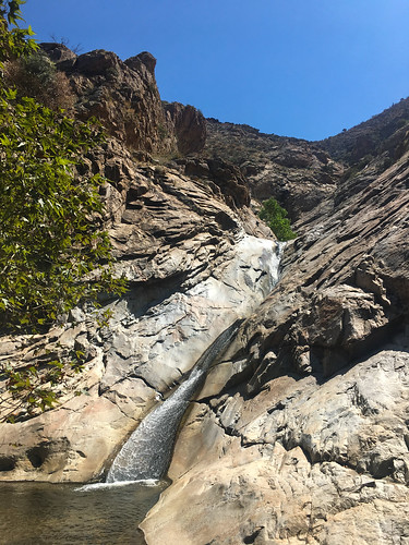
Lowest waterfall/slide in Frye Canyon
picnic area above the Gila River
The Gila River isn't running too high today
Muddy Gila River
Gila River under the Black Hills Back Country Byway bridge
lots of mud in the Gila River
Mt. Graham International Observatory from Webb Peak fire lookout
remnants of the Frye Fire on Webb Peak
looking down the Ash Creek drainage to the Gila Valley from Webb Peak
Webb Peak fire lookout - the floor burned out during the Frye Fire in July 2017
Frye Fire-burned trees on Webb Peak
The Pinaleno Mountains from Webb Peak fire lookout - University of Arizona's Mt. Graham International Observatory on the high peak in the distance
Webb Peak fire lookout - ironically charred by the Frye Fire in July 2017
Riggs Lake from the outlet
Riggs Lake panorama
Riggs Lake boat launch
Riggs Lake
Quiet summer afternoon at Riggs Lake Campground
looking east towards the Gailuro Mountains from near Riggs Lake Campground
looking east from the Pinaleno Mountains near Riggs Lake Campground
Summer monsoons moving in over Riggs Lake, Coronado National Forest, Safford, Arizona
View of the Morenci Mine from a "scenic view" overlook
You know you're in Arizona when a scenic view is provided for a copper mine
View of the Morenci Mine from a "scenic view" overlook
Clifton, Arizona train station
Clifton, Arizona train station
Gray Peak panorama, Apache National Forest
Gray Peak, Apache National Forest
nice picnic site along the Coronado Trail
Looking east down Juan Miller Canyon
The Coronado Trail in between Morenci and Alpine, Arizona
Red Mountain from the trail below Rose Peak
looking east from below Rose Peak towards New Mexico
Red Mountain area, Apache National Forest
Red Mountain panorama from below Rose Peak
Looking down Deer Creek towards the Santa Teresa Mountains
Tortilla Trail junction
Tortilla Trail gate
East Divide Trail sign
Galiuro Wilderness panorama - Kennedy Peak
East Divide Trail cairn
IMG_8812
lightly used trail
grassy trail
Santa Teresa Mountains from the East Divide Trail
East Divide Trail
East Divide Trail panorama, Kennedy Peak up canyon
Galiuro Wilderness
looking north from the East Divide Trail, Santa Teresa Mountains in the distance
remnants of fire
Kennedy Peak trail sign
the trail to Kennedy Peak is in and out of the drainage - overgrown, slow going either way
overgrown trail
East Divide Trail canyon
looking down canyon towards the Santa Teresas
looking at the Santa Teresa Wilderness from the Galiuro Wilderness
East Divide Trail
East Divide Trail junction
nice spot for lunch - Winchester Mountains in the distance
the trail is to the right of the sign even though you can't see it
East Divide Trail view
Santa Teresas panorama from the trail below Kennedy Peak
Tortilla Trail, Galiuro Wilderness
Tortilla Trail panorama
fence, no gate
the signs here could use some work
Mud Spring, Galiuro Mountains
Sycamore Trail junction
an interesting mix of signs for the Tortilla and Sycamore Trails
Santa Teresas from the Sycamore Trail
Sycamore Trail
Tortilla Trail sign
there are a lot of signs out here
IMG_8911
IMG_8866
IMG_8806
large panorama of the Pinalenos, Winchesters, and Galiuros from the Cottonwood Trail in the Santa Teresa Mountains.
Cottonwood Mountain from near the trailhead
The Pinalenos, Winchesters, and Galiuros from the Cottonwood Trail in the Santa Teresa Mountains.
Cottonwood Mountain from near Sand Tank
modest sign at the Santa Teresa Wilderness boundary
Holdout and Black Rock Canyons from near Cottonwood Mountain
pines at the saddle on the way to Cottonwood Mountain
looking south from the Cottonwood Mountain trail towards the Winchesters and Galiuros
fun rocks around Holdout Canyon, Santa Teresa Wilderness
another panorama of the Pinalenos, Winchesters, and Galiuros from the Cottonwood Trail in the Santa Teresa Mountains.
Cottonwood Mountain Trail
fun cactus along the Cottonwood Mountain trail
The Winchester Mountains and Galiuro Mountains from the Cottonwood Trail in the Santa Teresa Mountains
Cottonwood Mountain Trailhead at Sand Tank
yet another panorama of the Pinalenos, Winchesters, and Galiuros from the Cottonwood Trail in the Santa Teresa Mountains.
Holdout and Black Rock Canyons
multi-range pano from Cottonwood Trail
Navajo Generating Station and the Colorado River, Page, Arizona
1
2
3
4