Explore
What’s New
New!
Recent Photos
Trending
Events
The Commons
Flickr Galleries
World Map
Camera Finder
New!
Flickr Blog
Prints
The Print Shop
Prints & Wall Art
Photo Books
✨ Get Pro
Pro Plans
Stats Dashboard
Get Auto-Uploadr
Log In
Sign Up
✨ Get Pro
Log In
Explore
What’s New
New!
Camera Finder
New!
Trending
Events
The Commons
Flickr Galleries
Flickr Blog
The Print Shop
Prints & Wall Art
Photo Books
Back to albums list
Download
Share
Arizona
read more
read less
by
Matt McGrath Photography
read more
read less
395 photos
·
139 views
Frye Canyon Road heading into the Pinaleno Mountains
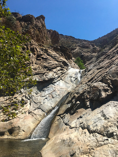
Lowest waterfall/slide in Frye Canyon
picnic area above the Gila River
The Gila River isn't running too high today
Muddy Gila River
Gila River under the Black Hills Back Country Byway bridge
lots of mud in the Gila River
Mt. Graham International Observatory from Webb Peak fire lookout
remnants of the Frye Fire on Webb Peak
looking down the Ash Creek drainage to the Gila Valley from Webb Peak
Webb Peak fire lookout - the floor burned out during the Frye Fire in July 2017
Frye Fire-burned trees on Webb Peak
The Pinaleno Mountains from Webb Peak fire lookout - University of Arizona's Mt. Graham International Observatory on the high peak in the distance
Webb Peak fire lookout - ironically charred by the Frye Fire in July 2017
Riggs Lake from the outlet
Riggs Lake panorama
Riggs Lake boat launch
Riggs Lake
Quiet summer afternoon at Riggs Lake Campground
looking east towards the Gailuro Mountains from near Riggs Lake Campground
looking east from the Pinaleno Mountains near Riggs Lake Campground
Summer monsoons moving in over Riggs Lake, Coronado National Forest, Safford, Arizona
View of the Morenci Mine from a "scenic view" overlook
You know you're in Arizona when a scenic view is provided for a copper mine
View of the Morenci Mine from a "scenic view" overlook
1
2
3
4