
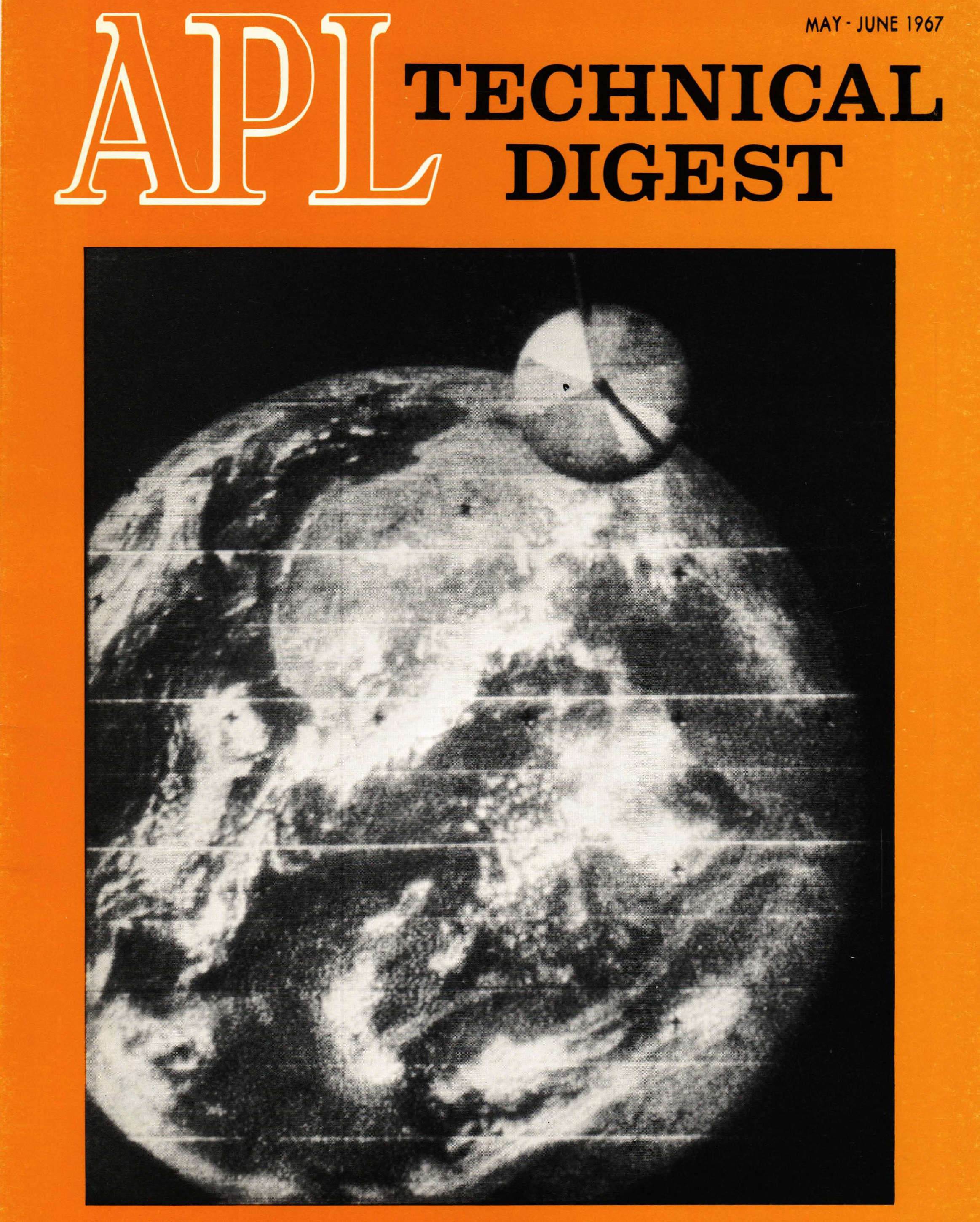
DODGE_v_bw_o_PLRD (1967, unnumbered prob. JHUAPL photo, film mfg code F709K5B)
An exceedingly rare, unicorn actually, black & white 1967 Polaroid photograph of the earth, taken by the Department of Defense Gravity Experiment (DODGE) satellite. I’m certain this was taken from/off a monitor at the Johns Hopkins University Applied Physics Laboratory (JHUAPL), possibly within the Satellite Communications Facility (SCF), where it was maybe received.
Despite being in black & white, i.e. taken through a single filter, the photograph's field of view, in addition to a subsequently linked image, confirms it to have been taken by the “22° - FIELD COLOR CAMERA”. See page 3 at the following:
www.jhuapl.edu/Content/techdigest/pdf/APL-V06-N05/APL-06-...
Credit: JHUAPL website
The barrel/mast of the satellite is within the camera’s field of view, highlighted by the crescent-like illumination of it by the sun.
Although not well defined in this, what I assume to be raw image, based on other processed images, the African continent occupies the upper right-hand quadrant of the earth’s disk. The lowest portion of the spherical color target/chart being at Turkey’s southern shores on the Mediterranean Sea.
4.25” x ~7.5” (at its maximum dimension). Actual image size is 3.5” x 4.5”. You can see where the required, hand-applied glossy/protective ‘print coater’ ends. I can almost smell the pungent acidic aroma…brings back fond memories of a simpler time.
The following wonderful site confirms the ‘originality’ of the photograph, with the manufacturing code of F709K5B on the verso breaking out to July 1967. So it was fresh film in the camera:
gawainweaver.com/images/uploads/file/Polaroid_ID.pdf
Credit: GAWAIN WEAVER ART CONSERVATION website
Interestingly, several different photographs taken by the satellite have been labeled as the “first color photo taken of the earth.” A few:
Note some similarity in cloud patterns. So possibly, the photographs were taken within a day or so of each other:
twitter.com/jhuapl/status/1121399208089661441
Credit: Johns Hopkins APL/Twitter
And then, from the Johns Hopkins University News-Letter website:
www.jhunewsletter.com/article/2019/09/apl-took-first-colo...
So, which is it?
Although not claimed to be the first, at least not on the cover, a nearly identical cloud pattern would indicate it’s from the same day, with the satellite apparently having rotated some between the photographs:
www.jhuapl.edu/Content/techdigest/images/issues/APL-cover...
Then there’s these unscrupulous SOBs. As expected, claimed to be the FIRST...from 1971. Greedy clueless bastards. Ironically though, it may be the exact same photograph. In fact, you can clearly see where the multiple (three) images of the spherical color target/chart have been ‘photoshopped’ from the image, which coincides with where it is in the Polaroid. They do at least acknowledge the image has been ‘enhanced’:
www.gettyimages.ie/detail/news-photo/view-of-the-first-co...
No credit due.
Wonderful & amusing anecdotal information associated with the DODGE image at the following:
www.donaldedavis.com/2003NEW/NEWSTUFF/DDEARTH.html
Credit: "Don Davis: Space Artist and Animator" website (lots of good stuff here)
Launched 1 July 1967, aboard a Titan III-C, the United States Navy's DODGE satellite was primarily intended to explore gravity-gradient stabilization at near-geosynchronous altitude. DODGE carried 10 booms that were radio-commanded to extend or retract along three different axes. Data from in-orbit experiments provided fundamental constants for use in controlling future high-altitude spacecraft. DODGE also carried a number of commandable magnetic-damping devices and two TV cameras to determine satellite alignment. One of the cameras also provided the first color pictures of the full Earth.
Slightly paraphrased description, credit: David Darling/The Worlds of David Darling
Excellent information:
www.jhuapl.edu/TechDigest/Detail?Journal=A&VolumeID=6...
Credit: “JOHNS HOPKINS UNIVERSITY, APPLIED PHYSICS LABORATORY” website
Also:
“The DODGE (Department of Defense Gravity Experiment) satellite was orbited primarily to study a number of advanced biaxial and triaxial gravity-gradient stabilization techniques at near-synchronous altitudes. Secondary objectives included obtaining measurements of the earth's magnetic field at near-synchronous altitudes and black-and-white and color TV photography of the entire earth disk. DODGE was launched as part of a multiple DOD satellite payload that included DATS 1, LES 5, and IDCSP 16, 17, and 18. The satellite was in the form of an octagonal aluminum shell with a truncated pyramid at the top and a 25.4-cm-diameter cylindrical mast extending 1.57 m from the satellite base. The satellite body was 2.41 m long and 1.22 m in diameter. A total of 10 knobbed booms were carried on board. Upon radio command, these booms could be independently extended or retracted along three axes to various limits out to 45.75 m. The cylindrical mast housed a 4.6-m boom that extended through the end of the mast, two 15.25-m-long damper booms that extended in the x-y plane, and triaxial vector magnetometer sensors. The remaining seven booms were contained in the satellite body along with a two-camera (one color and one black-and-white) vidicon camera system. The command system consisted of a dual command receiver, dual command logic, and power switching circuitry. The telemetry system included two directional antennas mounted on the mast, two 38-channel commutators for housekeeping data, and a dual transmitter system that transmitted analog data at a frequency of 240 MHz and TV data at 136.8 MHz. The satellite was successfully stabilized 12 days after launch by means of the gravity-gradient booms and libration dampening systems. It was oriented with its base and mast directed toward the center of the earth's disk. The mission was a success and proved the feasibility of achieving triaxial gravity-gradient stabilization at synchronous altitudes using passive and semipassive techniques. The satellite operated for over 3 yr and took thousands of black-and-white and color pictures of the earth. Early in 1971, problems with the batteries on board limited operation to only solar acquisition periods. The satellite was placed in an operational off mode in early 1971.”
Credit the NASA Space Science Data Coordinated Archive (NSSDCA) website, at:
nssdc.gsfc.nasa.gov/nmc/spacecraft/display.action?id=1967...