
vil2_v_c_o_TPMBK (unnumbered)
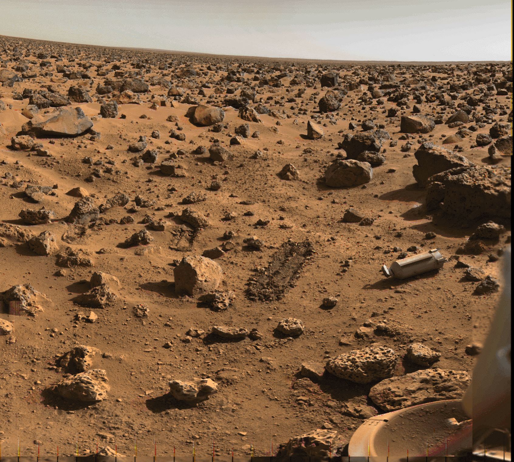
In an image taken by Viking Lander 2’s camera 2, shining on the Martian surface is the aluminum shroud, or cover, which protected the collector head of the surface sampler instrument during the vehicle’s year-long journey from Earth. On September 5, two days after Viking 2 landed, the surface sampler was rotated from its parked position atop the spacecraft and pointed downward about 40 degrees. The shroud was then ejected by a set of eight springs positioned around its base. It struck the porous rock at the bottom of the picture, bounced about 20 inches, hit the surface again and bounced another 20 inches. The scar left by the second bounce is faintly visible halfway between the shroud and the rock it struck. The shroud is 12 inches long and 4 1/2 inches in diameter. The large rock just beyond it is about 2 feet long and about a foot thick. At lower right is footpad of one of the spacecraft s three landing legs.
A trench previously dug by the surface sampler is visible immediately above & slightly to the left of the rounded rock directly to the left of the shroud. The trench was dug September 25, 1976 in the collection of a soil sample for Viking 2's molecular analysis experiment.
The description of an image of that trench being dug:
“Operation of the surface sampler in obtaining Martian soil for Viking 2's molecular analysis experiment last Saturday (September 25) was closely monitored by one of the Lander cameras because of the precision required in trenching the small area--8 by 9 inches-surrounded by rocks. Dubbed 'Bonneville Salt Flats,' the exposure of thin crust appeared unique in contrast with surrounding materials and became a prime target for organic analysis in spite of potential hazards. Large rock in foreground is 8 inches high. At left, the sampler scoop has touched the surface, missing the rock at upper left by a comfortable 6 inches, and the backhoe has penetrated the surface about one-half inch. The scoop was then pulled back to sample the desired point and (second photo) the backhoe furrowed the surface pulling a piece of thin crust toward the spacecraft. The initial touchdown and retraction sequence was used to avoid a collision between a rock in the shadow of the arm and a plate joining the arm and scoop. The rock was cleared by 2 to 3 inches. The third picture was taken 8 minutes after the scoop touched the surface and shows that the collector head has acquired a quantity of soil. With surface sampler withdrawn (right), the foot-long trench is seen between the rocks. The trench is three inches wide and about 1 1/2 to 2 inches deep. The scoop reached to within 3 inches of the rock at far end of trench. Penetration appears to have left a cavernous opening roofed by the crust and only about one inch of undisturbed crust separates the deformed surface and the rock.”
Above, and image, at:
photojournal.jpl.nasa.gov/catalog/PIA00145
Additionally, associated with an image taken after shroud ejection and at least two trenching/sampling operations:
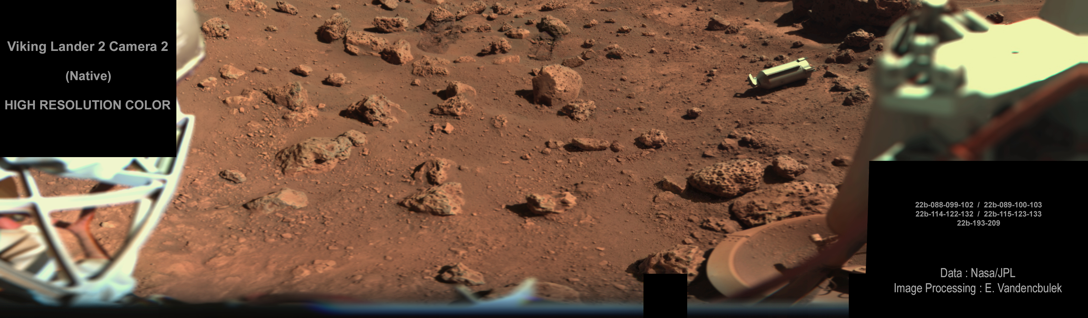
"This image was acquired at the Viking Lander 2 site with camera number 2. The rounded rock in the center foreground is about 20 centimeters wide. The angular rock to the right and further back than the rounded rock is about 1.5 meters across. The dark facet on the upper right edge of the angular rock has a color similar to basalts on Earth. There are two trenches that were dug in the regolith to the right of the rounded rock, as well as one behind and slightly to the left. The gently sloping troughs between the artificial trenches and the angular rock which cut from the middle left to the lower right corner of the picture are natural surface features.
This synthetic high resolution color image was created by combining standard low resolution Viking Lander color images with standard high resolution Viking Lander black and white images, using image processing techniques. In simple terms, the colors are separated from the color image. Using the computer, those colors are then painted onto high resolution images covering the same area. The image has had its colors balanced to approximate what a person would see on Mars. Since the Martian atmosphere carries extremely fine-grained red dust in suspension the "on Mars" images are redder.
Credit: Mary A. Dale-Bannister, Washington University in St. Louis."
Image at:
nssdc.gsfc.nasa.gov/image/planetary/mars/vikinglander2-2.jpg
Credit: NSSDCA website
Since the posted photograph was nowhere to be found - with a useful description/identification that is - the description I provided & augmented, is based on that of the following image, which at least is readily available:
photojournal.jpl.nasa.gov/catalog/PIA00527
The ONLY version of the image that I came across:
planetary.s3.amazonaws.com/web/assets/pictures/20160408_v...
Credit: The Planetary Society website
Finally, the view prior to shroud jettison & trenching/sampling activities:
photojournal.jpl.nasa.gov/catalog/PIA00568
Credit: JPL Photojournal website
I suppose it's somewhere in here:
pds-geosciences.wustl.edu/viking/vl1_vl2-m-lcs-2-edr-v1/v...
Credit: Planetary Data System website
You know, I’m really tired of being unable to find photographs, that in my opinion, should be much more readily available/searchable. The frustration is endless & infuriating. That, combined with the all too often prevalent pabulum 'official' descriptions, which in turn are all to often erroneous, sometimes glaringly, is a disservice - to all.
Preservation of the visual record of a remarkable history demands substantially more commitment & attention to detail.
vil2_v_c_o_TPMBK (unnumbered)
In an image taken by Viking Lander 2’s camera 2, shining on the Martian surface is the aluminum shroud, or cover, which protected the collector head of the surface sampler instrument during the vehicle’s year-long journey from Earth. On September 5, two days after Viking 2 landed, the surface sampler was rotated from its parked position atop the spacecraft and pointed downward about 40 degrees. The shroud was then ejected by a set of eight springs positioned around its base. It struck the porous rock at the bottom of the picture, bounced about 20 inches, hit the surface again and bounced another 20 inches. The scar left by the second bounce is faintly visible halfway between the shroud and the rock it struck. The shroud is 12 inches long and 4 1/2 inches in diameter. The large rock just beyond it is about 2 feet long and about a foot thick. At lower right is footpad of one of the spacecraft s three landing legs.
A trench previously dug by the surface sampler is visible immediately above & slightly to the left of the rounded rock directly to the left of the shroud. The trench was dug September 25, 1976 in the collection of a soil sample for Viking 2's molecular analysis experiment.
The description of an image of that trench being dug:
“Operation of the surface sampler in obtaining Martian soil for Viking 2's molecular analysis experiment last Saturday (September 25) was closely monitored by one of the Lander cameras because of the precision required in trenching the small area--8 by 9 inches-surrounded by rocks. Dubbed 'Bonneville Salt Flats,' the exposure of thin crust appeared unique in contrast with surrounding materials and became a prime target for organic analysis in spite of potential hazards. Large rock in foreground is 8 inches high. At left, the sampler scoop has touched the surface, missing the rock at upper left by a comfortable 6 inches, and the backhoe has penetrated the surface about one-half inch. The scoop was then pulled back to sample the desired point and (second photo) the backhoe furrowed the surface pulling a piece of thin crust toward the spacecraft. The initial touchdown and retraction sequence was used to avoid a collision between a rock in the shadow of the arm and a plate joining the arm and scoop. The rock was cleared by 2 to 3 inches. The third picture was taken 8 minutes after the scoop touched the surface and shows that the collector head has acquired a quantity of soil. With surface sampler withdrawn (right), the foot-long trench is seen between the rocks. The trench is three inches wide and about 1 1/2 to 2 inches deep. The scoop reached to within 3 inches of the rock at far end of trench. Penetration appears to have left a cavernous opening roofed by the crust and only about one inch of undisturbed crust separates the deformed surface and the rock.”
Above, and image, at:
photojournal.jpl.nasa.gov/catalog/PIA00145
Additionally, associated with an image taken after shroud ejection and at least two trenching/sampling operations:
"This image was acquired at the Viking Lander 2 site with camera number 2. The rounded rock in the center foreground is about 20 centimeters wide. The angular rock to the right and further back than the rounded rock is about 1.5 meters across. The dark facet on the upper right edge of the angular rock has a color similar to basalts on Earth. There are two trenches that were dug in the regolith to the right of the rounded rock, as well as one behind and slightly to the left. The gently sloping troughs between the artificial trenches and the angular rock which cut from the middle left to the lower right corner of the picture are natural surface features.
This synthetic high resolution color image was created by combining standard low resolution Viking Lander color images with standard high resolution Viking Lander black and white images, using image processing techniques. In simple terms, the colors are separated from the color image. Using the computer, those colors are then painted onto high resolution images covering the same area. The image has had its colors balanced to approximate what a person would see on Mars. Since the Martian atmosphere carries extremely fine-grained red dust in suspension the "on Mars" images are redder.
Credit: Mary A. Dale-Bannister, Washington University in St. Louis."
Image at:
nssdc.gsfc.nasa.gov/image/planetary/mars/vikinglander2-2.jpg
Credit: NSSDCA website
Since the posted photograph was nowhere to be found - with a useful description/identification that is - the description I provided & augmented, is based on that of the following image, which at least is readily available:
photojournal.jpl.nasa.gov/catalog/PIA00527
The ONLY version of the image that I came across:
planetary.s3.amazonaws.com/web/assets/pictures/20160408_v...
Credit: The Planetary Society website
Finally, the view prior to shroud jettison & trenching/sampling activities:
photojournal.jpl.nasa.gov/catalog/PIA00568
Credit: JPL Photojournal website
I suppose it's somewhere in here:
pds-geosciences.wustl.edu/viking/vl1_vl2-m-lcs-2-edr-v1/v...
Credit: Planetary Data System website
You know, I’m really tired of being unable to find photographs, that in my opinion, should be much more readily available/searchable. The frustration is endless & infuriating. That, combined with the all too often prevalent pabulum 'official' descriptions, which in turn are all to often erroneous, sometimes glaringly, is a disservice - to all.
Preservation of the visual record of a remarkable history demands substantially more commitment & attention to detail.