
Sept 00 - Azeris in Tabriz, NW Iran
Here I'm in one of those diners popular with the locals (it's more crowded than you can tell in this photo), and I'm eating a bowl of abgusht (pron. ah-pooshed) a delicious stew, but very carefully and very slowly as it's full of small bone sherds broken for the marrow. It's a Tabrizi specialty, "made with fatty meat, typically beef or mutton, thick chunks of potato and lentils." (LP) Other patrons here were smoking the hookah.
- These men are Azeris, Turkic-speaking Shiites, members of the largest minority in Iran (@ 25% of the total pop.!). West and East Azerbayjan provinces are majority Azeri.
- Tabriz is a city of @ 1.5 million, the 6th largest in Iran and the 4th largest I would tour in Iran that trip. It's a legendary city, known for its great splendour as a capital in the Il-khanate, the Qara Qoyunlu and Aq Qoyunlu states, and in the early Safavid period. But it's a cerebral place for a tourist. Many once-glorious Persian cities are, as earthquakes have cleared away most of its late-medieval monuments.
GARDEN of EDEN - More from the Book of Genesis: "Biblical clues point to the Ajichay river flowing out of the Garden of Eden, which places Tabriz at the gates of paradise!" (LP, 2012) Genesis 2:8-14 reads: "A river flows out of Eden to water the garden, and from there it divides and becomes 4 branches. The name of the 1st is Pishon; it's the one that flows @ the whole land of Havilah, where there is gold; and the gold of that land is good; bdellium and onyx stone are there. The name of the 2nd river is Gihon; it's the one that flows @ the whole land of Cush. The name of the 3rd river is Hiddekel [Tigris], which flows east of Assyria. And the 4th river is the Perath [Euphrates]." British archaeologist David Rohl claims to have located and identified the biblical Garden of Eden as the Adji Chay valley in which, or just west of which, Tabriz sits and which extends east @ 150 clicks to the city of Sarab ('Edin' is Sumerian for plain or steppe, see a map at the 32:20 min. pt. in the doc. in the link below) on the basis of the following argument. He suggests that the Gihon and Pishon are the Aras (or Araxes) river and the Uizhun. Before the Islamic invasion, the Aras was known as the Gaihun. "Victorian dictionaries had referred to it as the Gihon-Aras." Pishon is the Hebrew corruption of Uizon, wherein labial 'U' becomes labial 'P', 'z' becomes 'sh', and 'o' and 'u' are well accepted linguistic variations. The headwaters for all 4 rivers are in the region of this valley or plain. (But the Adji Chay isn't their source. Again, "a river flows out of Eden, ... and divides and becomes 4 branches." And from what I can see in the map in the video in the link to follow, the headwaters of the Tigris and the Euphrates are west and NW of Lake Ourumiyeh, respectively. Something to google.) www.ramsdale.org/dna6.htm The wider area is "packed with landmarks that retain their biblical names. North of the Adji Chay river valley rises the Kusheh Dagh, the mtn. of Kush. Beyond it lay the biblical land of Cush, Rohl asserts. "The bible tells us that the Gihon flows through the land of Cush", and the Araxes, the biblical Gihon, "winds through" the area. The Uizhun is known locally as the Golden river and meanders /b/ ancient gold mines and lodes of lapis lazuli, matching the biblical account. "East of Eden" [or just east of the river valley or plain hemmed in by mtn.s to the north, east, and south, and beyond a pass] is a rural district named Noqdi ['belonging to Noq'], which could be Cain's land of Nod. Some km.s south of Noqdi, at the head of a mtn. pass, lies the sleepy town of Helabad, www.google.com/maps/place/Hellabad,+Ardabil+Province,+Ira... formerly Kheruabad, "settlement of the Kheru people," which could be "a permutation of the Biblical word Keruvim ['Cherubim'], the ferocious winged guardians of Eden's eastern gateway. The name in Genesis is normally read as a reference to some type of angel, but Rohl suggests that the Keruvim, or 'Cherubs', were a tribe of fearsome warriors whose token was an eagle or falcon, and who only morphed into otherworldly creatures by later tradition." ("So He drove the man out. And He placed cherubim east of the garden of Eden with a sword of fire that turned every way. They kept watch over the path to the tree of life.") Wow! A series of coincidences or clues? It seems I might've spent 3 days in the Garden of Eden (in Tabriz!) or only @ 40 clicks west of it. What a miss! tiborkrausz.com/html/features/Paradise Found.html (Rohl's findings or theories were publicized in 1999 just before I took this trip, but I'm only reading about them now [in 2023]. Nobody tells me anything.)
- Rohl argues that the ancient Sumerians might've descended from people who lived in this 'Edin' (or plain, literally) east of Lake Ourumiyeh in a warmer period, and then moved south into southern Mesopotamia. (They might've been driven from their home by violent invaders or by an epidemic or drought, more the rule than the exception when prehistoric peoples moved en masse.) A legend then developed as an expression of their nostalgia for life in the mtn.s (there's no stone in southern Mesopotamia; I can take rocks for granted at times I confess), which then spread throughout much of the Middle and Near East, transmuting into the biblical tale in Genesis. What's most remarkable, if Rohl's right (and the coincidences with all the names listed above really do rack up), is the evidence that the author(s) of Genesis knew where the former site of the 'Garden' was on the map, so to speak. He or they knew it as a real place that had fallen from grace, a location that could be visited.
- I wonder what kind of access a Judaean might have had (if any) to the Adji Chay river valley as a traveller or trader in the early 1st mill. B.C. (Long-distance trade was alive and well then. Lapis lazuli was traded great distances from Afghanistan.) It was within or just south of the land of Aratta (quite possibly Ararat [Urartu]) on the other side of Assyria until the early 6th cent. B.C., and was NE of the north-eastern extent of the Neo-Babylonian empire in lands newly-conquered by the Medes, enemies of the Babylonians, during the period of the Babylonian exile. The description and co-ordinates given are so specific, it seems the author(s) received a credible, current account of the place (if he didn't visit it himself), wherever it is.
- Rohl makes his pitch.: youtu.be/jjuYYFn1cXk He recommends the lower slopes of Mt. Sahand (the 'Mountain of God' in Genesis he suggests), the old town of Osku in particular, 15 clicks SW of Tabriz, with its orchards, olive groves, walnut and almond trees, ancient giant plane tree and silk-weaving workshops, as the place to seek a glimpse of the inspiration for Genesis 2-3. Sarab at the east end of the valley and surrounding villages, groves, and orchards, look inviting as well, and Sarab is in the valley itself, near its 'Eastern gate'. (Sarab's old brick mosque has 2 old minarets topped with huge storks' nests.)
- A final point is that Rohl's assertions re these names listed above should be fact-checked wherever possible (although I haven't found an article or anything online that debunks them yet), b/c his other work is dodgy. He famously argues for a shift in the Egyptian chronology by 300-350 yr.s, such that the Amarna period of Akhenaten becomes that of the Early Monarchic period in Israel so as to identify the grand 12th-13th cent. BC ruins of what's been accepted as a Canaanite centre at the site of Jerusalem in that period with David and Solomon, for whose 10th-cent.-BC reign such ruins are conspicuous by their absence. Without touching on carbon-dating, this article debunks his Egyptian re-set handily.: anarchic-teapot.net/david-rohl-how-to-fail-a-test-of-time/ I think he tells a white lie when he says he's not religious (let alone a fundamentalist), that he hasn't sought to support the accuracy of the Bible, his discoveries are happen-stance, etc. His mask might've slipped a bit when he spoke to Peter Martin about historical figures who "apparently knew" where Noah's Ark was (on Mt. Judi Dagh in SE Turkey), which of course implies that Noah's Ark was a thing.
TABRIZ CITY HISTORY: - An Iron-age cemetery from the early 1st mill. B.C. has been excavated near the Blue mosque, the city was referred to as Tarui or Taruis in a royal Assyrian epigraph dating from 714 B.C., and is said to have been 'founded' by Jhosrow Arshakid (Arsacid) of Armenia in @ 220. Following the Muslim conquest, the Arab Azd tribe from Yemen settled in what was then a Sassanian village. In 791, Zubaidah, wife of the Abbasid caliph Harun al-Rashid, rebuilt Tabriz following a devastating earthquake and beautified the city such that she was (also) credited with founding it. Earthquakes in 858 and 1042 levelled any structure from the pre-Islamic period. By the end of the 10th cent. it was such a prosperous centre for trade that it was chosen as the venue for the marriage celebrations of the Seljuq sultan Tughril Beg and a daughter of the caliph of Baghdad.
- At Ramadan in 1208, Tabriz and its adjacent territories, then under Seljuq rule, were conquered by the Kingdom of Georgia under Queen Tamar the Great, in response to the (infamous) massacre of 12,000 Christians by the Seljuqs in the Georgian-controlled city of Ani on Easter day. In nearby Ardabil, the Georgians slew as many as 12,000 Muslims (in a tit for tat?).
- Following the Mongol invasion, Tabriz came to eclipse Maragheh as the 2nd Il-Khanid (Mongol) 'royal' capital of Azerbaijan, chosen by Abaqa Khan (r 1265-'81), 4th ruler of the Ilkhanate, in @ 1265 for its favoured location in the northwestern grasslands. "Even then [the locals] had a reputation for business acumen as the city's traders rioted over the introduction of paper money to replace coinage." Western visitors to Tabriz in the 13th cent. would consistently gush as to the magnificence of the city and its bldg.s. Marco Polo described it in 1275 as "a great and noble city. ... The men of Tauris get their living by trade and handicrafts, for they weave many kinds of beautiful and valuable stuffs of silk and gold. The city has such a good position that merchandise is brought thither from India, Baudas [Baghdad], Cremesor [aka Garmsir, the Gulf coast], and many other regions; and that attracts many Latin merchants, Genoese in particular, to buy goods and transact other business there; the more as it is also a great market for precious stones. It is a city in fact where merchants make large profits." (But he then refers to "a medley of different classes" in the city, and to "the natives of the city themselves", the Taurizi, as "a very evil generation." [He's generally regative re 'worshippers of Mahommet."]) In 1295, Abaqa's successor Ghazan Khan made Tabriz the administrative centre of an empire stretching from Anatolia to the Oxus river and from the Caucasus to the Indian Ocean. Under his rule, new city walls, many public buildings, schools, an enormous mausoleum, bazaars, and caravanserais were built to serve traders travelling the Silk road, but little remains of these. But, his conversion to Islam was marked by persecution of all non-Muslims in the region and the razing of all churches, synagogues and Zoroastrian temples in town.
- The Byzantine Greek astronomer Gregory Chioniades served as the city's Orthodox bishop during this time. Born in @ 1240 and raised in Constantinople, he "received assistance from Alexios II and travelled to Persia where he lived in Tabriz from 1295 to '96 and translated a number of Arabic and Persian works on mathematics and astronomy, incl. the astronomical tables of his teacher Shams al-Din al-Bukhari who had worked at the famous observatory at Maragheh under the polymath Nasir al-Din al-Tusi. Chioniades played an important role in transmitting several innovations from the Islamic world to Europe, incl. the universal latitude-independent astrolabe and a Greek description of the Tusi couple." (Wikipedia) He returned to Tabriz as a bishop in 1302 and stayed until at least 1310. (But what about Ghazan Khan's persecution of Christians?)
- From the mid-14th cent., Tabriz and the surrounding area came under the control of various warlords, and the city was sacked by Timur in 1392. The Turcoman Qara Qoyunlu ('Black Sheep') tribal chiefs made Tabriz their capital from 1436 to 1467 when Jahan Shah was slain in an ambush and the city was taken by Uzun Hassan of the Aq Koyunlu ('White Sheep') who located their capital there from 1469 to 1501. The 'Blue mosque' dates to the Qara Qoyunlu period. Ismail I entered Tabriz in 1501 and proclaimed it the capital of his Safavid state. He was crowned there, and it was at Tabriz where he momentously declared the Twelver branch of Shi'ite Islam as the official religion of the Safavid empire. The primarily Sunni population of Tabriz was then forcibly converted to Shi'ism. In 1514, following the Persian defeat at the Battle of Chaldiran, Tabriz was sacked by Selim I (the Grim). On July 16, 1534, prior to the Ottoman conquest of Baghdad, Pargalı Ibrahim Pasha occupied Tabriz. In 1555, Tahmasp I transferred the Safavid capital to Qazvin to avoid the growing Ottoman threat, ending a period of 290 yr.s in which Tabriz had been the capitol of much of the medieval Middle East. Tabriz came under Ottoman occupation from 1585 to 1603, was retaken by the Safavids under Abbas I, and then grew as a centre of commerce and of trade with the Ottoman empire, Russia, and the Caucasus. Tabriz was then occupied and sacked by Murad IV in 1635 in the Ottoman-Safavid War (1623–39), was returned to Persia with the Treaty of Zohab in 1639, and was devastated by a strong earthquake in 1641.
- The 18th cent. was an unhappy one for Tabriz. It was shocked by a deadly earthquake in 1721 that killed @ 80,000, and was then invaded by the Ottomans in 1724-'25 who took many captives and massacred @ 200,000 (!). When the Persians retook the city, a famine and an epidemic killed more of the survivors. In 1780, a major earthquake killed @ 50,000 (an estimate, some say as many as 200,000), leaving only @ 30,000!
- The Persians were such accomplished engineers, I wonder how they designed their cities and their larger buildings to withstand earthquakes, as the Incas, the Chinese and Japanese famously did. Or might there have been less emphasis on seismic threats because Islam means submission? www.theguardian.com/environment/2003/dec/27/iran.naturald... This article explores vernacular measures taken in the construction of adobe bldg.s in Yazd to anticipate earthquakes, such as reducing their weight and lowering their centre of gravity, and the use of "thick spandrel walls and vaults which function as transversal stiffeners and enhance vault lateral capacity." built-heritage.springeropen.com/articles/10.1186/s43238-0... The Times of India claims that the Tomb of Cyrus at Pasargadae is the world's oldest earthquake resistant structure. timesofindia.indiatimes.com/travel/destinations/do-you-kn... It's not true. Ancient coastal Peruvians employed very effective "shicra bags in the foundations of their monumental step pyramids" @ 5,000 yr.s ago, more than 2,000 yr.s before Cyrus. They filled these mesh bags "with river cobbles and piled them behind retaining walls and into the bases of the terraces of their temples." roseannechambers.com/buildings-that-last/ But "[a]n Iranian newspaper has quoted a Tehran risk management official as reporting that 60% of the city's bldg.s don't meet seismic standards and would be heavily damaged if a major earthquake hit." One official in the city's 'risk management dept.' said that 20% of Tehran's bldg.s would be "completely destroyed". The standards are on the books, but enforcement is lax. www.rferl.org/a/iran-earthquake-risks-damage/31439140.html temblor.net/earthquake-insights/a-personal-cry-by-an-iran...
- In the late 18th cent., the city was divided into several districts, each ruled by a family until 1799 when Qajar Prince Abbas Mirza was appointed governor. In the Qajar era the city was the residence of the Crown Prince, who would serve as governor of Azerbaijan province as well. (Something similar in 15th-16th cent. Amasya where, by tradition, the Ottoman crown prince was sent "to be taught statecraft, and to test his knowledge and skill as governor of the province." The Qajar shahs were of Turkish stock.) Prince Eristov marched into the city with 3,000 troops and captured it in the Russo-Persian War of 1826-'28. The 'Peace of Turkomanchay' signed by Abbas Mirza and Ivan Paskevich in 1828 ceded Iran's Caucasian territories (Georgia, southern Dagestan, Azerbaijan and Armenia, prior to which "Tabriz had been instrumental to the implementation of Iranian rule in [those] territories"), and the Russians left Tabriz having received a crippling war indemnity. Abbas Mirza then launched a modernization scheme from Tabriz, introduced Western institutions, imported industrial machinery, installed the first regular postal service, and undertook military reforms in the city. He launched a rebuilding campaign and established a modern taxation system. Tabriz became a city of Iranian 'firsts'. It was home to the first publication house, public library, public cinema, primary school, kindergarten, municipality, chamber of commerce, firefighting dept., telephone system, power plant, industrial factories, public limited co., etc. (Wikipedia, etc.)
- "Heavy-handed Qajar attempts to 'persianize' the Azeri reqion caused resentment. The 'Constitutional revolution' of 1906 briefly permitted Azeri Turkic-speakers to regain linguistic rights (schools, newspapers, etc.) and Tabriz held out valiantly in 1908 when the liberal constitution was promptly revoked again. For its pains it was brutally besieged by Russian troops [again]", etc. (LP, 2012)
- www.youtube.com/watch?v=gusgQNkFLYw
- I was happy with the moserferkhane (sp?) that I found and stayed at in Tabriz, @ $5.00 per night. My memory's fuzzy but I recall sleeping in a bed that was raised quite high atop some structure and that I had to climb up to with a ladder, although it wasn't a 'bunk-bed' (? possibly above wall storage cabinets), and which was very clean and comfortable with white sheets. It wasn't luxurious but it was perfect. I was well-rested in Tabriz and spent 3 days there (I think).
- As to sites and sights, I followed the LP and toured the following.:
- The ARG (Citadel), one of 4 massive eivans of what "must have been one of the largest mosques ever constructed" (LP), the Masjed-e-Shah (Il-Khanate, 1312-'22), built of brick with a huge mihrab /b/ 2 arches and visible from afar, it was once coated in tile panels. (I'll scan a photo.) The mosque was "the brainchild of a vizier in Oljeitu's court. Judging from the surviving height (26 m.s) and thickness (10.5 m.s) of the walls of the eivan, it's thought that the one leading to the prayer chamber stood @ 66 m.s high, with the vault springing starting at @ 24.5 m.s, with a staggering vault span of almost 31 m.s, much wider than anything attempted in 14th cent. Europe." (Bradt) A point of local pride was that the vault was larger than the famous, ancient (Sassanian! pre-Islamic) vault of Khosrow/Kisra, the Taq-i-Kisra at Ctesiphon in latter-day Iraq, 37 m.s high, 26 across and 50 m.s long, said to be "the largest man-made, free standing vault constructed until modern times", but apparently not. (Fie those earthquakes!). "Chronicles describe the mosque as having a huge 285 x 228 m. marble-paved courtyard, surrounded by an alabaster-columned arcade and with an ablution pool so large that, 2 centuries later, Shah Ismail I would sail across it in a barge. Its minarets, soaring > 60 m.s high, were said to have so impressed envoys from the Mameluke court of Cairo that they influenced the design of those built in 1330 at the Mosque of Amir Qarasunqur in Cairo (no longer extant)." (Bradt) The compound also included adjoining prayer halls, libraries, and a mausoleum. Most of it collapsed in the earthquake of 1641, although later that century "there was [still] enough cover to conduct the Friday prayer."
- In 1809, the Qajar governor converted the structure into a citadel, "a large acropolis fortification (whence the metathetic name Ark or Arg plus polis)", and built a barracks, headquarters, cannon foundry and a small palace on-site. The Qajar general Samson Makintsev, a Ukrainian deserter from the Russian army, lived in the citadel for years with his wife, the daughter of Prince Aleksandre of Georgia. en.wikipedia.org/wiki/Samson_Makintsev
- In that period, "criminals were hurled from the top of the Arg into a ditch below. It's said that one woman sentenced to this end was saved from death by the parachute-like effect of her chador." (LP)
- "The Arg's defenses were finally dismantled in the late 19th cent., and by then not one tile panel remained." (Bradt)
- The Russians shelled the Arg in yet another invasion in 1911, and then used it as a command centre. In the Pahlavi era, parts of it which were presumed to date from the Qajar era were removed, and in the process much of the much older Il-khanid and Safavid elements were unwittingly destroyed. It now adjoins an empty plaza and is handy to a vast, controversial new mosque (the construction of which is said to have undermined the Arg's foundations).
Encounters with architectural and engineering superlatives like this would recur over my 3 mos. in Iran.
- The 'BLUE MOSQUE', Masjed-e Kabud (1465, Qara Qoyunlu): Its construction was on the orders of Saliha Khanum, daughter of Jahan Shah, or of his wife Khatun Jan, and was completed in 1465, 2 yr.s before Jahan Shah was slain in an ambush (Bradt) and Tabriz was taken by Uzun Hassan of the Aq Koyunlu. Following the Safavid defeat at Chaldiran in 1514, the Ottomans looted Tabriz and the mosque, absconding with at least 8 carpets, taken to Istanbul. The mosque was damaged in several earthquakes /b/ the 16th and 18th cent.s, and most severely in 1780 (Wikipedia, 1776 according to Bradt) when only the entrance eivan was left standing, although the mosque had been abandoned by then. (That quake had an estimated magnitude of 7.4, a maximum felt intensity of IX on the Mercalli Intensity Scale, and almost entirely destroyed the city. The number of reported casualties varies from 40,000 to as many as 200,000, with a 'best estimate' of 50,000.) Locals looted its ruins in the 19th cent. Reconstruction began in 1973 (according to Wikipedia, 1950 according to Bradt, 1960 according to the LP), and much of it's been rebuilt, incl. the dome (since 2000).
- It's renowned for the fine, chromatic, mosaic tiling which once coated the interior and exterior walls, but which is now fractured and fragmentary, although still glorious. The tiles were of such quality that they represent something of a height or pinnacle of achievement in their production, or so I've read. (But Esfahan? Sheikh Lotfollah?) www.flickr.com/photos/bijantaravels/3032399359/ www.flickr.com/photos/bijantaravels/46464373821/ www.youtube.com/watch?v=53gifnSsXGI The Kufic and Thuluth inscriptions, arabesque compositions and patterns were created by the famous calligrapher Nematollah-ben-Mohammad-ol-Bavab. www.youtube.com/shorts/7AwUyTuKYvQ "Modern glazes rarely match the jewel-like intensity and depth of colour" in the tiles that remain. (Bradt) This mosque was my reintroduction to the height of this art-form after my tourism in Istanbul and Bursa (where the famous 'Green mosque' and 'Green tomb' were decorated by Persian 'Masters of Tabriz' in the early 15th cent.) and which I'd see much more of later at Esfahan (!) and Yazd.
- It was designed in the 'covered mosque' plan of 9 domes, incl. the central dome (diameter 16 m.s), more often found in early Ottoman architecture. The ground plan is similar to the 'T-shaped' mosques of 15th cent. Bursa (such as the Green mosque), but the function, emphasis and proportions differ. (Bradt)
- The importance of this mosque was emphasized with the great pains taken to preserve and reconstruct much of it, and the remaining tiles are lovely, but I'd appreciate it more today than I did then. Again, most of the sites and sights in Tabriz are cerebral. It's on Iran's 'Tentative list' for Unesco designation.
- A video re the Blue mosque led me to this video (1 of 3 from 'Gamesquad') of this group playing a strange boardgame, 'Secret Hitler' (a "social deduction game for 5-10") with fascists v. liberals. youtu.be/P0KHFO9Jekc It reminds me of how well the average young, University-educated Iranian in the big cities speaks English, better than the average German, even in Berlin, and much better than les Quebecois in much of rural Quebec. It also reminds me of how strange it was to travel in a country for 3 mos. where much of the population dress like nuns.
- The CHURCH of ST. MARY (Armenian, 1785): I'm a fan of Marco Polo, of course (I travelled to Montreal in 2014 to take in this exhibit at the Pte.-à-Callière: pacmusee.qc.ca/en/exhibitions/detail/marco-polo-an-epic-j... ), and looked forward to touring this church as the LP ('92) had written that "there's been a sizeable Armenian community in Tabriz from the earliest days of Christianity, and the city boasts a number of churches, incl. one mentioned by Marco Polo. Probably the most interesting is the old but [very] substantially rebuilt Church of St. Mary." But there's no reference in Marco Polo's 'Travels' to any church in 'Tauris' (Tabriz). (?) The 12th-cent. church that he allegedly visited in 1271, and which served as the seat of the Armenian archbishop of Azerbaijan, stood on-site until the city was destroyed in the earthquake of 1780. The current domed bldg., 16 x 14 m.s, was built upon its ruins "in Safavid style" from 1782 to '85 per an inscription. "The oldest gravestone [inside] dates to the 16th cent." and "parts of the tabernacle date to the 12th" (Wikipedia), but I was disappointed. It was in a spacious, sunny compound, but aside from an old plaque or 2 preserved in its walls, it appeared to be entirely new with little atmosphere. See for yourself from the 13 min. pt. in this French vlog.: www.youtube.com/watch?v=SMeiye6ZRYU Again, tourism in Tabriz was often cerebral (and later in Hamadan and Shiraz too). Preserve thoroughly, renovate sparingly.
- The SAHEB-OL-AMR MOSQUE and medrese (1636, Safavid, reconstructed 1694-1722) www.flickr.com/photos/bijantaravels/52021115783/ This was the most atmospheric sight that I toured in the city and not so cerebral. Built in 1636 by Tahmasp I, destroyed in 1638 by Murad IV, then rebuilt and then badly damaged in an earthquake, the mosque was finally rebuilt by Goli Khan Danbali. "In favour of the people" it was named Sāheb ol Amr, the title of the last 'Twelver' Shī‘ite Imām, Muhammad al-Mahdi, which is to say that Danbali was being selfless in not naming it after himself. (Wikipedia)
- It wasn't in my LP guide (not much was), and I was surprised when I came across it. It's large, wide, and domed, with rows of false pointed arches along the exterior and with twin minarets with ornate brickwork and little metal domes or cupolas raised on poles at the tops to shelter the muezzin (something I hadn't seen before). It was visibly ancient and seemed exotic. My memory's hazy (again) but I explored it and it definitely wasn't crowded if it wasn't entirely or almost entirely empty. Old, dim and quiet with high ceilings, what I recall best is a pair of tall wooden doors that open onto a prayer-room to the right of the entrance, entirely coated on the side facing the room with small, round or oval metal faces with unibrows which I assumed had been tacked up by local supplicants, one at a time. There were some metal hands as well, but far fewer (more likely in Shi'ite cultures to represent the hands of Abulfazl Abbas, who lost them as punishment for bringing water to Imam Hussein's children, than 'the hand of Fatima', a shield against jealousy and the evil eye). These were charms or offerings of some type and seemed very un-Islamic (Islam is iconoclastic), possibly syncretistic. www.flickr.com/photos/peteshep/5258476665/ (I'll scan a photo.) This kind of thing can be common in Catholic churches, as congregants will attach photos of loved ones etc. to a particular wall. (One in this cathedral in San Antonio is covered with photos.: www.flickr.com/photos/97924400@N00/15458532657/in/photoli... ). I didn't see these for sale in town.
- I just found this on-line.: pdfs.semanticscholar.org/e50c/9711a8b2ea0d1634041424cc285... "Metal Decorations of Door of Saheb al-Amr Mosque in Tabriz: Azerbaijan Folk Art from Qajar Era", in the 'Journal of History, Culture and Art Research' (2019). They're of "low-grade silver and brass" and many are inscribed with prayers for divine assistance, verses from the Koran, or spells. The most interesting point in the article, made at the end, is that such metal faces or masks hadn't been used or found in any other mosques or shrines in Iran. Their use was unique to the culture of the members of this one congregation. Wow.
- The mosque, or bldg. (if it's no longer a functioning mosque), now houses a 'Qur'an museum' with exhibits in cases.
- The BAZAAR, has become the most celebrated attraction in Tabriz following its designation by Unesco in 2010. I didn't know it when I explored part of it (or until I read this just now), but it's the largest covered bazaar in the world. Labyrinthine, "it covers some 7 km.s with 24 separate caravanserais and 22 impressive timchehs (domed halls). Construction began over a millenium ago, although much of the fine brick-vaulting is 15th cent. There are several carpet sections, organized according to knot-size and type. The spice bazaar has a few shops that still sell herbal remedies and natural perfumes. ..." (LP)
- This complex has long been one of the most important commercial centres on the Silk Road, having stood on the same site since the early periods of Iranian urbanism following the arrival of Islam. Al-Maqdisi (in the 10th cent.), Yaqut al-Hamawi (@ 1213), Zakariya al-Qazwini (@ 1252), Marco Polo (1271), Odoric of Pordenone (@ 1321), Ibn Battuta (@ 1330), Ambrogio Contarini (1474), Hamdallah Mustawfi (13th to 14th cent.), John Cartwright (1606), Jean Chardin (in the time of Suleiman I of Persia), Jean-Baptiste Tavernier (@ 1636), Giovanni Francesco Gemelli Careri (@ 1642) and dozens of other explorers and historians have written about it.
- During Ashura merchants cease trading for @ 10 days and religious ceremonies are held inside the bazaar. Several mosques have been constructed behind it, incl. the Jameh mosque. (Wikipedia)
- The walls are cleaner, lighter and brighter today, following restoration with much sand-blasting, than they were in 2000. It's a bit like a grand mosque, with high ceilings in a very long series of pointed arches, with lofty, round sky-lights and domes supported by elaborate squinches, all built with fine, small bricks. I preferred the bazaar in Esfahan, but this in Tabriz has Unesco designation for good reason.
- Some 19th and/or early 20th cent. Tabrizi bldg.s have some European baroque architectural or decorative features. I'll scan a shot of some large, relatively intact pieces of decorative, white stucco work in a pile on the ground somewhere (that would've been snapped right up in the west) which include images of the faces of cherubs with long, wild hair above their heads.
- The AZERBAIJAN MUSEUM.: I spent the better part of my last day in town touring this history and archaeology museum (with the 2nd largest collection in Iran from a range of periods and cultures in the country's history; the proto-Elamite, Elamite, Mitanni, Median, etc. through to the Qajar, after the Bastam in Tehran [Wikipedia]), perusing its ancient and medieval coins, seals, much sculpture (incl. some fine Sassanian metal plates or disks with reliefs), ceramics, calligraphy, etc., and the obligatory ethnographic collection. The item I remember best is the Basmala or 'Sang-e Bism Allah stone', intricately carved in 1845 by Mohammad-Ali Qhochani (Mirza Sanglakh) in Cairo, a huge, marble masterpiece with a large central inscription, in the photo in the next link. (It helps that I have a postcard of it in a bound collection I bought in town. In Tabriz I had returned to the world of postcards, quality ones.) 'Besm Allah', 'In the name of Allah' is from the phrase "In the name of God, the Most Gracious, the Most Merciful", one of the most important phrases in Islam, used by Muslims before performing 'good deeds', daily prayers, etc. Those words commence each surah in the Koran, apart from the 9th.
commons.wikimedia.org/wiki/File:Besm_allah_stone.jpg en.wikipedia.org/wiki/Azerbaijan_Museum#
- The POET'S MAUSOLEUM, Maqbarat-o-shoara (1971, modernist) - I toured this monument on my return visit to Tabriz in December, and I'll write about it here.: www.flickr.com/photos/97924400@N00/3471850513/in/datepost...
- I might vaguely recall the Tabriz Municipal bldg. with its distinctive clock tower (1934), built under the supervision of German architects. I didn't tour the municipal museum inside, but I don't know that it was a miss apart from a room with 12 Tabrizi carpets.
Misses in Tabriz include:
- The Armenian 'Church of St. Sergius' (Sarkis), renovated in 1845 and a bit Russian in appearance.
- The "curious" Anglican church "has a tower of 4 diminishing cylinders." (LP, '12). There are some 6 churches in town but I only recall the one (see above).
- The Jame mosque (11th-12th cent., renovated or rebuilt after 1779), a miss as I don't see how I could've forgotten its dramatic entrance.: en.wikipedia.org/wiki/Jameh_Mosque_of_Tabriz#/media/File:...
- 'The Constitution House' (1868), a "Qajar-era courtyard house, headquarters for rebels during the 1906-'11 Constitutional revolution" (LP);
- The Imāmzādeh Hamzah (14th cent.), a pilgrimage site with the tomb of Hamzah, son of the Twelver Shī‘ah Imām, Mūsā al-Kāzim and a founder of the Safavid dynasty (!);
- The shrine of On ibn Ali on Eynali mtn. (a large park) just north of town, a tomb for 2 Muslim clerics which had initially been a Sassanid Zoroastrian temple (also !);
- Ruins of the Rab'-e Rashidi University or academic community (Ilkhanid, 1307 at the latest until after 1501), founded and endowed (with @ 50,000 dinars, a huge sum) by Rashid-al-Din Hamadani, vizier to Ghazan Khan, it received "provision for > 100 employees, @ 1/4 labourers and the rest skilled professionals, 220 slaves, and salaried students [i.e. with scholarships] from Iran, China, Egypt, and Syria." Early manuscripts of the Jami' al-Tawarikh and the Great Mongol Shahnameh were produced there, as well as the 1st global history (!), with sections or chapters on Mongolia (of course), China, India, the Jews, and the Franks, books on plants and agriculture, medicine, etc. "The most prominent extant ruin might be the foundation of an observatory mentioned in Rashid al-Din's writings." (Wikipedia, etc.) www.youtube.com/watch?v=30g_yHmgusM www.youtube.com/watch?v=_3S6oiWkaCY
- Several Tabrizi museums have come about since 2000 incl. the now-famous Qajar museum (2006) in the Amir Nezām mansion; the 'Iron Age museum' (2006) built to showcase an Iron Age cemetery and items found there; the Qur'an museum in the Saheb-ol-Amr mosque; and the photogenic Hariree house (Qajar, 19th cent.).: en.wikipedia.org/wiki/Hariree_House#/media/File:Hariri_Ho...
- A big miss 62 clicks south of town was the very photogenic and now very popular troglodyte town of Kandovan, a little piece of Cappadocchia where locals live in ancient, multi-level homes carved out from the volcanic tuff. (Get a better guidebook!) www.youtube.com/shorts/nNvqXBUC3bo
- Ardabil was a big hike from Tabriz, 3 1/2 hr.s, 215 clicks east towards the Caspian, but a mausoleum-shrine complex there, that of Sheikh Safi-od-din-Ardabili (1252/3-1334, dervish-Sufi mystic, founder of the Safaviyya order and eponymous forebear of the Safavid dynasty), is my 3rd or 4th biggest miss in the country. A work in progress from the 14th to the 17th cent.s, the exterior is impressive but the interior is about as delicate and dazzling as any I've seen anywhere or seen photos of, at least that I can think of (apart from the Sistine chapel). With its "'Chini Khaneh', 'China room' (1612), honeycombed with ‘stalactite’-vaulted, gilt niches designed to display the royal porcelain collection" carted off to the Hermitage by the Russians (LP), etc., it competes with the best in Samarkand, Khiva, Esfahan, etc., although on a more intimate scale.
From Tabriz I took a long-distance bus @ 30 clicks SE down the 16 to the fork with the 21, then @ 80 south down the 21 to Bonab and the fork with the 24, and then east @ 15-20 clicks to Maragheh. I passed Mamqan a few clicks west of the 21, a town claimed to be the largest producer of chickpeas in the world. The biggest miss that leg of my trip was the Mithraic cave temple near the village of Qadamgah, less than 10 clicks SE of the 21 and @ 12 S. of Azarshahr, a vast domed chamber sculpted out from a natural cave or from the living rock. www.youtube.com/shorts/UWrNiJvG7HM
- I only passed through Bonab on the bus, but it's at least 6,000 yr.s old and "has 25 registered historical national monuments, 8 under protection." (What are they?) The Mehrabad mosque is filled with "splendid wooden columns under colourful, faceted capitals dated to 1083." (LP) The city has "the only nuclear research centre in the NW of the country" where "the laser ion argon 10 was first produced in the Middle East." It's known for laser and thyatron production, etc. But Bonab is famous for one thing, Bonab Kebab (mixed ground beef and lamb). Not only is it the best in Iran, it was registered as 'National Intangible Cultural Heritage' in 2015, so it's official. youtu.be/1JWgA70aXOU
- "Archeologists hope a newly-discovered tunnel in Bonab will lead them to the legendary city of Shiz, dating back 7,000 yr.s. [??] ... The tunnel is 12 km.s long [? I wouldn't buy 1 km., let alone 12] and 0.8 m.s high [a qanat?] and clearly reveals the impact of sledge hammers used to burrow it. Experts speculate it might have served as an escape route for the city's nobility." Shiz was one of the most prosperous cities in ancient Persia with a pop. of > 10,000 at its height and is believed to predate Susa. Experts can't agree on its location. (Wikipedia, etc.)
MARAGHEH (Marag-huh) was a city with a pop. of < 150,000 in 2000, but with an out-sized importance to history as the capital, albeit briefly (only 7 yr.s) of the vast, new Il-Khanate in the mid-13th cent.
- It might've been ancient Phraata, winter capital of Atropatene, as it was known as 'Afrah-rudh' in the 10th cent. and as 'Afrazah-rudh' in the 12th-13th, which might have derived from Phraata. The Umayyad prince Marwan ibn Muhammad briefly stayed at Maragheh following his expedition to Muqan and Gilan in 740. It was in this period that the settlement was given the name Maragheh ('place where an animal rolls') due to the large quantity of dung there. A perimeter wall was erected and a garrison established there (803 or later) on the orders of Khuzayma ibn Khazim, governor of Adharbayjan and Arminiya in response to the rebellion of Wajna ibn Rawwad, Lord of Tabriz. Caliph al-Mam'un (r. 813–833) restored the walls following the rebellion of Babak Khorramdin in 816/17. Khaydhar ibn Kawus al-Afshin used Maragheh as his winter quarters during his expedition against Babak. To reduce the unstable autonomy of the Arab chieftains of Adharbayjan and curb the dominance of the Bagratid kings of Armenia, Caliph al-Mu'tamid installed Muhammad ibn Abi'l-Saj (of the Sajid family, native to Ushrusana, likely Soghdian) as governor of Adharbayjan and Armenia in @ 892. When rebel 'Abd-Allah ibn al-Hasan ibn al-Hamdani took control of Maragheh in 893, Muhammad convinced him to surrender by promising his safety, but then executed him anyway. Muhammad then made Maragheh his capital (although he was more often in Barda'a) and amassed so much authority that he briefly declared independence from the caliphate. He died in an epidemic in 901, his troops installed his son Devdad ibn Muhammad on the throne, and 5 mos. later his uncle Yusuf ibn Abi'l-Saj usurped, destroyed the city walls, and moved his capital to Ardabil. Yusuf was acknowledged as the ruler of Adharbayjan and Armenia in 909 by the new caliph al-Muqtadir. The last Sajid ruler, Abu'l-Musafir al-Fath, was killed at Maragheh in 929.
- Maragheh and much of Azerbaijan were then contested and held by the Daylamite Sallarids, the Buyids, the Kurdish Rawadids, Oghuz Turks, and the Seljuqs. The Seljuq brothers and rivals Berkyaruq and Muhammad I Tapar signed a peace treaty near Maragheh in 1104. One Ahmadil ibn Ibrahim ibn Wahsudan (who might've been Rawadid, the 1st of the Ahmadili dynasty) was appointed ruler of Maragheh in 1111/12, and was succeeded by his slave Aq Sunqur (who engaged in much intrigue with unsuccessfully rebellious Seljuq princes, was dismissed and somehow reappointed as governor). "The last Ahmadili ruler of Maragheh, Sulafa Khatun (r. 1209–1225) was at Ru'in Dez", the local "impregnable fortress", during the storming and burning of Maragheh and the slaughter of its inhabitants by the Mongols on March 30, 1221. In 1225, the Khwarazmshah of the Anushtegins, Jalal al-Din Mangburni (r. 1220–1231) entered and conquered Maragheh easily due to local discontent with recent raids and oppression by the raiding Georgians.
- Mongol rule over Maragheh and the region was solidified in 1231. Following his conquest of Baghdad in 1258, Hulagu Khan (r 1256-'65), ruler of the vast Il-Khanate, established his residence and his court at Maragheh. He died from an illness and was buried on the island of Shahi in Lake Ourumiyeh with a shamanist funeral (together with many beautiful, young virgins) in 1265, only 7 yr.s later. His successor, his son Abaqa Khan, moved the capital to Tabriz in 1265 or soon thereafter. By 1340, Maragheh was the capital of a tuman, which included the southern portion of Azerbaijan. (All Wikipedia, etc.)
- I spent a night in Maragheh and recall eating a restaurant meal and reading or writing at a table outside by a busy street after dark. I saw most of what I'd see in and @ town the next day.
- I wrote (on the back of a photo) in 2002 that Maraghe "is known for the excellence of its seedless grapes. the best I remember ever having." ! At least I remembered them then, 20 yr.s ago, lol.
- I vaguely recall touring the interesting but small 'Il-Khanate museum' with its surfeit of ancient hand-written books, collection of coins, ceramics and all manner of things from the Il-khanid period, Maragheh's heyday in the 13th-14th cent.s.
- The main attraction (according to the LP in '92, but not really, see below) are 4 gonbads, medieval tomb towers.:
1. The GONBAD-e SORKH ('Red', Seljuq, 1147): The oldest of the bunch, tall and boxy, 8.4 m.s2 in area, 10 m.s high, with 2 blind pointed-arches on 3 of its sides, it reminds me a bit of a British telephone-booth. The pyramidal roof above the dome is long gone. It has 7 inscriptions incl. Koranic verses and was built by architect Bani Bakr Mohammad Ibn Bandan Ibn Mohsen Memar per the order of Abd al-Aziz Ibn Mahmoud Ibn Saad Yadim, Seljuk governor of Azerbaijan (although it's uncertain if he's the occupant).
- Holes in the sides of the bldg. were used like a sundial to determine the months of the year and the hours of the day (before construction of the local observatory). It's the most recent bldg. constructed in the 'Razi' architectural style in Iran, popular in the time of the Samanid and Seljuk empires and the Khwarazmian dynasty. (Wikipedia) I've read that it's the oldest known structure in which turquoise tiles or faience is combined with decorative brickwork (as seen in the tall entrance with its central, Kufic inscription), a big deal. The decorative brickwork fills each of the blind arches.
2. The BORJ-e MODAVAR ('Round', Seljuq, 1167): It stands, photogenically juxtaposed, next to the Gonbad-e Kabood. (I'll scan a photo). Per its name, it's cylindrical and much simpler than the other tombs, apart from its ornate entrance portal, with delicate, interlacing brickwork and two inscriptions in blue faience.
3. The GONBAD-e KABOOD ('Blue', Seljuq, 1197): A decagonal, brick tower, 14.5 m.s tall, it's been (falsely) attributed to the Christian mother of Hulagu Khan (not with those Koranic verses in its Kufic inscriptions). There's a blind pointed-arch on each of its 10 sides, within which the surfaces are entirely covered in complex strap brickwork with raised, interlacing hexagons and 6-pointed stars, like a large web. There's much muqarnas vaulting covered in dense, labyrinthine patterns in brick and mosaic faience. It's by far the busiest of the gonbads and the most memorable. Much of it's badly damaged (and in photos online, it looks worse for wear than it did in 2000 I think), but it's > 800 yr.s old and delicate.
commons.wikimedia.org/wiki/File:Gonbadkabod.jpg
4. The GONBAD-e GHAFFARIYEH (Il-Khanid, 1325-'28): Named after a local school, it's another boxy, square, brick construction on a stone platform, with pairs of blind pointed-arches on 3 of its sides, and contains a main chamber above a crypt. But the brick used is a darker red and all inscriptions are in the Rayhani script. What's left of the decorative blue tiles (both turquoise and sky blue) is impressive. I've read that it's thought to be the tomb of one Shams al-din Qara Sunghur "who worked for both the Egyptian Mamluks and then the Il-Khanids as a local governor. He was also 'Master of the Royal Polo', indicated by the heraldic device of 2 polo sticks." (Bradt). But the presenter in the Press TV clip in the link below advises that it's the tomb of the 9th Il-Khanate Khan, Abe Saeed Bahadur (?).
- iolanda-andrade.blogspot.com/2017/06/my-19-day-iranian-az...
- www.tehrantimes.com/news/465808/Maragheh-tomb-towers-on-t...
- See 2 of these gonbads to the 6 min. pt. in this Press-TV clip.: www.youtube.com/watch?v=7becD8x5yJs
- To tour Towers 1, 2 and 3, above, "I had to pay a man from the museum a fee (and taxi-fare) to accompany me to 2 locked courtyards. He unlocked the Gonbads as well." (written on the back of a photo 20 yr.s ago, but which I don't recall. youtu.be/zTIVI6JLQUE youtu.be/063qvy0QJos ) I toured the 4th on my own.
- I don't recall the Gonbad-e Arqala or Aghalar, which looks (in photos online) to be plainer in appearance and shorter but wider. It contains a museum today.
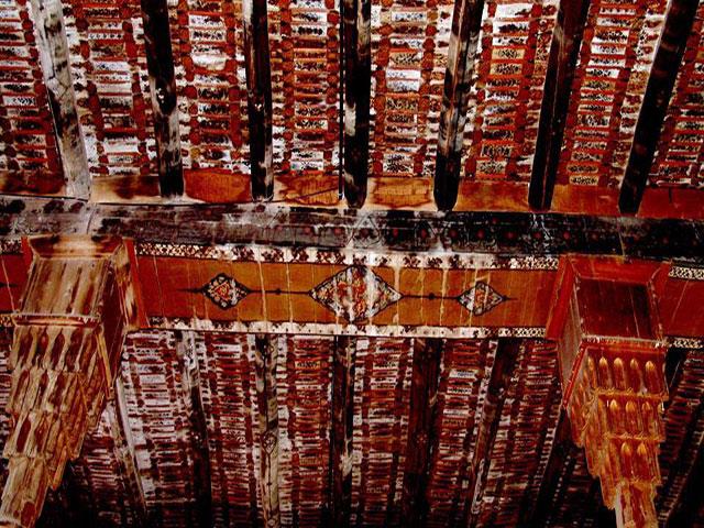
- The MOLLA ROSTAM MOSQUE (Safavid, 16th cent., rebuilt in the Qajar era): Said to have been built by one 'Haj Ali Khan Moghaddam Maraghe'e', it's spacious, under a flat wooden ceiling supported by rows of 35 octagonal wooden pillars, with stalactite-carving on the capitols which connect with beams which support perpendicular logs which in turn support long rows of long, narrow, wooden slats, parallel to the beams. Medallions are painted on the beams and logs, and detailed floral and foliate images with tiny medallions on each slat /b/ the logs. It's a very busy ceiling with one painstaking paint-job. I liked that it (clearly) hadn't been renovated or touched up. tishineh.com/tour/Pictures/Item/3077/38532.jpg See it from the 7:07 min. pt. in this clip.: www.youtube.com/watch?v=7becD8x5yJs www.youtube.com/watch?v=tHHR65SOMi4&list=PLhxDUhiBSi9...
- The famous MARAGHEH OBSERVATORY (the greatest Observatory in the Medieval world!): The ruins of Hulagu khan's 13th cent. rasadkhune (observatory; known in it's day as 'the Star House') are on a low, flat-topped hill west of the city under a geodesic dome, and include a long, straight, flag-stone-paved, 3.1-m.-wide corridor with entrances to a series of long, rectangular rooms on both sides, and with the 'meridian', a straight gutter-like recess, running down its centre to the base of the 'Mural Quadrant' ( www.flickr.com/photos/97924400@N00/6337193475/in/photostr... ), originally with a radius of @ 40 m.s of which 5.5 m.s has survived, and which was used to calculate the position and motion of the sun (see below), all within the round base of what was once a large bldg., 22 m.s in diameter, and /b/ the thick foundations of the walls of its rooms. "The bldg., which no doubt served as a citadel as well, had a staff of at least 10 astronomers and a librarian, covered 340 x 135 m.s, and the foundations of the walls were 1.3 to 2 m.s thick." It made use of "a complex system of water wheels" (?). Instruments designed for it include the said quadrant, an armillary sphere with a radius of @ 160 cm.s, a solstitial armilla, an azimuth ring and a parallactic ruler (triquetrum). 5 circular platforms "on which astronomical instruments were placed" (I'll scan a photo of one) and the foundations of outbldg.s surround the site of the central tower, incl. one 330 m.s2, thought to have been the library which allegedly had holdings of @ 400,000 books (plundered by the Mongols from libraries across Persia, Syria and Mesopotamia, incl. "the legendary library of Alamut" where Tusi himself salvaged some works.) Some families of Iranian tourists were milling @. www.youtube.com/watch?v=rGYczp2WJpM
- "A mural instrument is an angle-measuring device mounted on or built into a wall. For astronomical purposes, such walls were oriented to lie precisely on the meridian. Mural instruments that measured angles from 0 to 90 degrees were called 'mural quadrants' and were utilized as astronomical devices in ancient Egypt and ancient Greece. ... To measure the position of a star, the observer needs a sidereal clock in addition to the mural instrument. With the clock measuring time, a star of interest is observed with the instrument until it crosses an indicator and 'transits the meridian'. The time on the clock is then recorded as well as the angular elevation of the star, yielding the position in the coordinates of the instrument. If the instrument's arc is not marked relative to the celestial equator, then the elevation is corrected for the difference, resulting in the star's declination." (Wikipedia)
- The Astronomical Observatory, as we know it, was a medieval, Islamic invention. www.youtube.com/watch?v=jqQYR6qYj4U And the Maragheh observatory (Il-Khanid, 1259-@'63) "represented new heights in the science of astronomy within Islam and the [wider] world" (Huff, "The rise of Early Modern Science"). It was the earliest and most successful of the 3 greatest astronomical observatories in the Muslim Middle East, incl. those in Islanbul (1420) and Samarkand (1577). (Why isn't this site on Iran's 'Tentative list' for Unesco designation?) "[T]he Chinese, having less hostile relations with Islam, and possibly through the intermediaries of the Mongols who sponsored the observatory, could have gained access to the most advanced astronomy in the world [!] 2 centuries before the West did." (Huff)
- "... The Maragha school of astronomers built [their] observatory with the hope of constructing new tables of observation that would surpass those of Ptolemy. Although this research team included such figures as al-Urdi, al-Tusi, Qutb al-Din al-Shirazi, and al-Maghribi [whose full name was Muhyī al‐Milla wa al‐Dīn Yahyā Abū ʿAbdallāh ibn Muhammad ibn Abī al‐Shukr al‐Maghribī al‐Andalusī], they didn't produce the observational database that might have displaced Ptolemy. Nonetheless, by adjusting various parameters they did create the first non-Ptolemaic planetary models, [but which] remained geocentric, ... [and] improved the Ptolemaic system such that its models were mathematically equivalent to [and preceded by > a century] those in the Copernican system. ... This is to say, (1) Copernicus [1473-1543] used the Tusi couple as the Maragha astronomers did ["a geometric system that includes a smaller circle within a larger circle twice its diameter. The rotations of the smaller circle allow a specific point on the circumference to oscillate in linear motion. The Tusi-couple solved many issues with Ptolemaic systems over planetary motion" and helped astronomers to understand how celestial bodies revolve around one another.], (2) his planetary models for longitude in the Commentariolus are very similar to those of Ibn al-Shatir, while (3) those for the superior planets in De Revolutionibus used Maragha models, and (4) the lunar models of Copernicus and the Maragha school are identical." (Huff) At the Maragheh and Samarkand observatories, the Earth's rotation was discussed by Najm al-Din al-Qazwini al-Katibi (d. 1277), Tusi (b. 1201) and Qushji (b. 1403). (Huff) The arguments and evidence used by Tusi and Qushji resemble those used by Copernicus to support the Earth's motion. (Wikipedia)
- financialtribune.com/articles/travel/3009/maragheh-the-je...
- "In 1256, the Mongols under Hulagu took the [infamous] Alamut castle [see my photo] where the religious scholar and astronomer Nasir al-Din al-Tusi (d. 1274) and several other scholars had taken refuge to continue their studies. Impressed with Al-Tusi's scholarship, Hulagu appointed him wazir or vizier, and then employed him to found and oversee the construction of the observatory. (According to one account, Al-Tusi appealed to Hulagu's superstitions and told him that he could predict the future with a good observatory.) This appears to have been done under the umbrella of the law of waqf, the religious law of endowments that al-Tusi understood as a legal scholar. This seems to be the first example of such use of Islamic law for these purposes." (Huff) But while Islam had initially generated and supported the observatory, it was Islam that would later destroy it. "Astronomers [maintained] that astronomy was a “handmaiden of religion”, as it was used to determine the new moon and time-keeping. Nonetheless it was associated with astrology whose assumptions ran counter to the tenets of Islam (and to those of Christianity too). If only God knows the future, those who claim such knowledge usurp his power and capacities. The decline of the observatory began in the late 13th cent., although it would survive the rule of 7 khans, incl. Abaqa and Uljaytu, and remained active for over 50 yr.s. > 100 astronomers conducted research in the facility in that period. ("It is believed that several Chinese astronomers worked at the observatory where they introduced several Chinese methods of computation.") The site became derelict as a result of a loss of funding, and damage sustained in earthquakes.
- en.wikipedia.org/wiki/Astronomy_in_the_medieval_Islamic_w...
- RASAD-KHANEH CAVES: A "MITHRAIC" TEMPLE or BUDDHIST or ?: I came upon an unusual cave complex, the Rasad-khaneh caves, just below and west of the observatory, carved out of the side of the hill. The ceilings of 2 chambers had been sculpted and smoothed, each like 2 sides of a triangle meeting at a point, like ceilings under a pitched roof. What look like large altars carved out from the living rock were in the centre of the floor in each. (I'll scan a photo.) There were subterranean levels and tunnels with much atmosphere. I used my flashlight or my camera flash to spelunk all through it. A vlogger and his friends explore some of it here.: www.youtube.com/watch?v=TxfCFZ7hPdU Some maintain that this was a mithraic temple complex, but Wikipedia refers to these sculpted caves as similar in style to Chinese and Mongol cave temples or shrines, and as having been used "for religious ceremonies in the Il-Khanid period." Oxford research fellow Arezou Azad writes that "[t]he rectangular stone blocks in chambers A and B were identified as altars, and hence the chambers as sanctuaries. To [Warwick] Ball they [resemble] the Buddhist circumambulatory pillar-caves of Afghanistan and Central Asia, and to Bowman and Thompson the Jacobite style of dual sanctuaries. I would also note a resemblance to the Sassanian fire altars of Balkh. ... In the cave temples of the Mithraists (or Mithraea), altars of such dimensions can also be found. An ancient Mithraic use is likely given the similarities with Roman Mithraic temples, but it is the Il-khanid period which is of greater interest to us." www.tertullian.org/rpearse/mithras/display.php?page=supp_...
- "Mithraic narratives state that Mehr was born in a cave and thus caves were considered important in the construction of mithraic temples. [Supplicants] performed their rituals in natural caves. ... The most important part of a temple was its altar, located at the end of the hall and including a small porch, built a little higher than ground level. The walls contained images of Mehr. ... [In the] hand-made caves of the Observatory hill ... platforms for sacrifice or on which images of Mehr were engraved are well preserved." www.cais-soas.com/CAIS/Archaeology/Ashkanian/verjuy_mithr...
- Dr. Amin Moradi is dismissive of "the traditional views of scholars" that the cave complex at Varjavi, nearby, is a mithraeum. link.springer.com/article/10.1007/s41826-022-00049-x "In the history of Zoroastrianism or Mazdayasna, Western Iran has been thought of as the heart of religious activity under the Median emperors (Herodotus). It's believed that after the unification of the Median and Achaemenid dynasties in 550 B.C., temples to Mithra, a Zoroastrian divinity, were constructed throughout the empire. (Malandra 1983, 88)." But he maintains that no evidence of any ancient mithraeum has been identified east of Syria (although they're found from Great Britain across the former Roman Empire to Dura Europos, and notwithstanding that the cult of Mithras is thought to have been adopted by Roman soldiers from its source in the worship of the Aryan pantheon in Parthian and Sassanian Iran.) No assumptions or inferences should be made as to Iranian mithraism on the basis of Roman mithraism. As to the purported mithraic cave-complex at Varjavi (which I write about in the next photo comment, a miss) Moradi suggests that it's an Il-Khanid-era tomb, "an attempt to try to copy the earlier Mongol construction methodologies in the Islamic context of Iran." He notes similarities in its layout with those of 7 cave 'dome tombs' that belong to clans of eastern Turks in Mongolia and which predate the Il-Khanate by /b/ @ 230 and 570 yr.s. But who was buried at Varjavi? All Khans are accounted for. Moradi admits that there's "no unknown Ilkhanid elite burial candidate for this monument in this region."
- After all that, I might find the evidence of the Buddhist nature of the Rasad-Khaneh caves (but not the Varjavi complex) to be most persuasive. (Cont.)
Sept 00 - Azeris in Tabriz, NW Iran
Here I'm in one of those diners popular with the locals (it's more crowded than you can tell in this photo), and I'm eating a bowl of abgusht (pron. ah-pooshed) a delicious stew, but very carefully and very slowly as it's full of small bone sherds broken for the marrow. It's a Tabrizi specialty, "made with fatty meat, typically beef or mutton, thick chunks of potato and lentils." (LP) Other patrons here were smoking the hookah.
- These men are Azeris, Turkic-speaking Shiites, members of the largest minority in Iran (@ 25% of the total pop.!). West and East Azerbayjan provinces are majority Azeri.
- Tabriz is a city of @ 1.5 million, the 6th largest in Iran and the 4th largest I would tour in Iran that trip. It's a legendary city, known for its great splendour as a capital in the Il-khanate, the Qara Qoyunlu and Aq Qoyunlu states, and in the early Safavid period. But it's a cerebral place for a tourist. Many once-glorious Persian cities are, as earthquakes have cleared away most of its late-medieval monuments.
GARDEN of EDEN - More from the Book of Genesis: "Biblical clues point to the Ajichay river flowing out of the Garden of Eden, which places Tabriz at the gates of paradise!" (LP, 2012) Genesis 2:8-14 reads: "A river flows out of Eden to water the garden, and from there it divides and becomes 4 branches. The name of the 1st is Pishon; it's the one that flows @ the whole land of Havilah, where there is gold; and the gold of that land is good; bdellium and onyx stone are there. The name of the 2nd river is Gihon; it's the one that flows @ the whole land of Cush. The name of the 3rd river is Hiddekel [Tigris], which flows east of Assyria. And the 4th river is the Perath [Euphrates]." British archaeologist David Rohl claims to have located and identified the biblical Garden of Eden as the Adji Chay valley in which, or just west of which, Tabriz sits and which extends east @ 150 clicks to the city of Sarab ('Edin' is Sumerian for plain or steppe, see a map at the 32:20 min. pt. in the doc. in the link below) on the basis of the following argument. He suggests that the Gihon and Pishon are the Aras (or Araxes) river and the Uizhun. Before the Islamic invasion, the Aras was known as the Gaihun. "Victorian dictionaries had referred to it as the Gihon-Aras." Pishon is the Hebrew corruption of Uizon, wherein labial 'U' becomes labial 'P', 'z' becomes 'sh', and 'o' and 'u' are well accepted linguistic variations. The headwaters for all 4 rivers are in the region of this valley or plain. (But the Adji Chay isn't their source. Again, "a river flows out of Eden, ... and divides and becomes 4 branches." And from what I can see in the map in the video in the link to follow, the headwaters of the Tigris and the Euphrates are west and NW of Lake Ourumiyeh, respectively. Something to google.) www.ramsdale.org/dna6.htm The wider area is "packed with landmarks that retain their biblical names. North of the Adji Chay river valley rises the Kusheh Dagh, the mtn. of Kush. Beyond it lay the biblical land of Cush, Rohl asserts. "The bible tells us that the Gihon flows through the land of Cush", and the Araxes, the biblical Gihon, "winds through" the area. The Uizhun is known locally as the Golden river and meanders /b/ ancient gold mines and lodes of lapis lazuli, matching the biblical account. "East of Eden" [or just east of the river valley or plain hemmed in by mtn.s to the north, east, and south, and beyond a pass] is a rural district named Noqdi ['belonging to Noq'], which could be Cain's land of Nod. Some km.s south of Noqdi, at the head of a mtn. pass, lies the sleepy town of Helabad, www.google.com/maps/place/Hellabad,+Ardabil+Province,+Ira... formerly Kheruabad, "settlement of the Kheru people," which could be "a permutation of the Biblical word Keruvim ['Cherubim'], the ferocious winged guardians of Eden's eastern gateway. The name in Genesis is normally read as a reference to some type of angel, but Rohl suggests that the Keruvim, or 'Cherubs', were a tribe of fearsome warriors whose token was an eagle or falcon, and who only morphed into otherworldly creatures by later tradition." ("So He drove the man out. And He placed cherubim east of the garden of Eden with a sword of fire that turned every way. They kept watch over the path to the tree of life.") Wow! A series of coincidences or clues? It seems I might've spent 3 days in the Garden of Eden (in Tabriz!) or only @ 40 clicks west of it. What a miss! tiborkrausz.com/html/features/Paradise Found.html (Rohl's findings or theories were publicized in 1999 just before I took this trip, but I'm only reading about them now [in 2023]. Nobody tells me anything.)
- Rohl argues that the ancient Sumerians might've descended from people who lived in this 'Edin' (or plain, literally) east of Lake Ourumiyeh in a warmer period, and then moved south into southern Mesopotamia. (They might've been driven from their home by violent invaders or by an epidemic or drought, more the rule than the exception when prehistoric peoples moved en masse.) A legend then developed as an expression of their nostalgia for life in the mtn.s (there's no stone in southern Mesopotamia; I can take rocks for granted at times I confess), which then spread throughout much of the Middle and Near East, transmuting into the biblical tale in Genesis. What's most remarkable, if Rohl's right (and the coincidences with all the names listed above really do rack up), is the evidence that the author(s) of Genesis knew where the former site of the 'Garden' was on the map, so to speak. He or they knew it as a real place that had fallen from grace, a location that could be visited.
- I wonder what kind of access a Judaean might have had (if any) to the Adji Chay river valley as a traveller or trader in the early 1st mill. B.C. (Long-distance trade was alive and well then. Lapis lazuli was traded great distances from Afghanistan.) It was within or just south of the land of Aratta (quite possibly Ararat [Urartu]) on the other side of Assyria until the early 6th cent. B.C., and was NE of the north-eastern extent of the Neo-Babylonian empire in lands newly-conquered by the Medes, enemies of the Babylonians, during the period of the Babylonian exile. The description and co-ordinates given are so specific, it seems the author(s) received a credible, current account of the place (if he didn't visit it himself), wherever it is.
- Rohl makes his pitch.: youtu.be/jjuYYFn1cXk He recommends the lower slopes of Mt. Sahand (the 'Mountain of God' in Genesis he suggests), the old town of Osku in particular, 15 clicks SW of Tabriz, with its orchards, olive groves, walnut and almond trees, ancient giant plane tree and silk-weaving workshops, as the place to seek a glimpse of the inspiration for Genesis 2-3. Sarab at the east end of the valley and surrounding villages, groves, and orchards, look inviting as well, and Sarab is in the valley itself, near its 'Eastern gate'. (Sarab's old brick mosque has 2 old minarets topped with huge storks' nests.)
- A final point is that Rohl's assertions re these names listed above should be fact-checked wherever possible (although I haven't found an article or anything online that debunks them yet), b/c his other work is dodgy. He famously argues for a shift in the Egyptian chronology by 300-350 yr.s, such that the Amarna period of Akhenaten becomes that of the Early Monarchic period in Israel so as to identify the grand 12th-13th cent. BC ruins of what's been accepted as a Canaanite centre at the site of Jerusalem in that period with David and Solomon, for whose 10th-cent.-BC reign such ruins are conspicuous by their absence. Without touching on carbon-dating, this article debunks his Egyptian re-set handily.: anarchic-teapot.net/david-rohl-how-to-fail-a-test-of-time/ I think he tells a white lie when he says he's not religious (let alone a fundamentalist), that he hasn't sought to support the accuracy of the Bible, his discoveries are happen-stance, etc. His mask might've slipped a bit when he spoke to Peter Martin about historical figures who "apparently knew" where Noah's Ark was (on Mt. Judi Dagh in SE Turkey), which of course implies that Noah's Ark was a thing.
TABRIZ CITY HISTORY: - An Iron-age cemetery from the early 1st mill. B.C. has been excavated near the Blue mosque, the city was referred to as Tarui or Taruis in a royal Assyrian epigraph dating from 714 B.C., and is said to have been 'founded' by Jhosrow Arshakid (Arsacid) of Armenia in @ 220. Following the Muslim conquest, the Arab Azd tribe from Yemen settled in what was then a Sassanian village. In 791, Zubaidah, wife of the Abbasid caliph Harun al-Rashid, rebuilt Tabriz following a devastating earthquake and beautified the city such that she was (also) credited with founding it. Earthquakes in 858 and 1042 levelled any structure from the pre-Islamic period. By the end of the 10th cent. it was such a prosperous centre for trade that it was chosen as the venue for the marriage celebrations of the Seljuq sultan Tughril Beg and a daughter of the caliph of Baghdad.
- At Ramadan in 1208, Tabriz and its adjacent territories, then under Seljuq rule, were conquered by the Kingdom of Georgia under Queen Tamar the Great, in response to the (infamous) massacre of 12,000 Christians by the Seljuqs in the Georgian-controlled city of Ani on Easter day. In nearby Ardabil, the Georgians slew as many as 12,000 Muslims (in a tit for tat?).
- Following the Mongol invasion, Tabriz came to eclipse Maragheh as the 2nd Il-Khanid (Mongol) 'royal' capital of Azerbaijan, chosen by Abaqa Khan (r 1265-'81), 4th ruler of the Ilkhanate, in @ 1265 for its favoured location in the northwestern grasslands. "Even then [the locals] had a reputation for business acumen as the city's traders rioted over the introduction of paper money to replace coinage." Western visitors to Tabriz in the 13th cent. would consistently gush as to the magnificence of the city and its bldg.s. Marco Polo described it in 1275 as "a great and noble city. ... The men of Tauris get their living by trade and handicrafts, for they weave many kinds of beautiful and valuable stuffs of silk and gold. The city has such a good position that merchandise is brought thither from India, Baudas [Baghdad], Cremesor [aka Garmsir, the Gulf coast], and many other regions; and that attracts many Latin merchants, Genoese in particular, to buy goods and transact other business there; the more as it is also a great market for precious stones. It is a city in fact where merchants make large profits." (But he then refers to "a medley of different classes" in the city, and to "the natives of the city themselves", the Taurizi, as "a very evil generation." [He's generally regative re 'worshippers of Mahommet."]) In 1295, Abaqa's successor Ghazan Khan made Tabriz the administrative centre of an empire stretching from Anatolia to the Oxus river and from the Caucasus to the Indian Ocean. Under his rule, new city walls, many public buildings, schools, an enormous mausoleum, bazaars, and caravanserais were built to serve traders travelling the Silk road, but little remains of these. But, his conversion to Islam was marked by persecution of all non-Muslims in the region and the razing of all churches, synagogues and Zoroastrian temples in town.
- The Byzantine Greek astronomer Gregory Chioniades served as the city's Orthodox bishop during this time. Born in @ 1240 and raised in Constantinople, he "received assistance from Alexios II and travelled to Persia where he lived in Tabriz from 1295 to '96 and translated a number of Arabic and Persian works on mathematics and astronomy, incl. the astronomical tables of his teacher Shams al-Din al-Bukhari who had worked at the famous observatory at Maragheh under the polymath Nasir al-Din al-Tusi. Chioniades played an important role in transmitting several innovations from the Islamic world to Europe, incl. the universal latitude-independent astrolabe and a Greek description of the Tusi couple." (Wikipedia) He returned to Tabriz as a bishop in 1302 and stayed until at least 1310. (But what about Ghazan Khan's persecution of Christians?)
- From the mid-14th cent., Tabriz and the surrounding area came under the control of various warlords, and the city was sacked by Timur in 1392. The Turcoman Qara Qoyunlu ('Black Sheep') tribal chiefs made Tabriz their capital from 1436 to 1467 when Jahan Shah was slain in an ambush and the city was taken by Uzun Hassan of the Aq Koyunlu ('White Sheep') who located their capital there from 1469 to 1501. The 'Blue mosque' dates to the Qara Qoyunlu period. Ismail I entered Tabriz in 1501 and proclaimed it the capital of his Safavid state. He was crowned there, and it was at Tabriz where he momentously declared the Twelver branch of Shi'ite Islam as the official religion of the Safavid empire. The primarily Sunni population of Tabriz was then forcibly converted to Shi'ism. In 1514, following the Persian defeat at the Battle of Chaldiran, Tabriz was sacked by Selim I (the Grim). On July 16, 1534, prior to the Ottoman conquest of Baghdad, Pargalı Ibrahim Pasha occupied Tabriz. In 1555, Tahmasp I transferred the Safavid capital to Qazvin to avoid the growing Ottoman threat, ending a period of 290 yr.s in which Tabriz had been the capitol of much of the medieval Middle East. Tabriz came under Ottoman occupation from 1585 to 1603, was retaken by the Safavids under Abbas I, and then grew as a centre of commerce and of trade with the Ottoman empire, Russia, and the Caucasus. Tabriz was then occupied and sacked by Murad IV in 1635 in the Ottoman-Safavid War (1623–39), was returned to Persia with the Treaty of Zohab in 1639, and was devastated by a strong earthquake in 1641.
- The 18th cent. was an unhappy one for Tabriz. It was shocked by a deadly earthquake in 1721 that killed @ 80,000, and was then invaded by the Ottomans in 1724-'25 who took many captives and massacred @ 200,000 (!). When the Persians retook the city, a famine and an epidemic killed more of the survivors. In 1780, a major earthquake killed @ 50,000 (an estimate, some say as many as 200,000), leaving only @ 30,000!
- The Persians were such accomplished engineers, I wonder how they designed their cities and their larger buildings to withstand earthquakes, as the Incas, the Chinese and Japanese famously did. Or might there have been less emphasis on seismic threats because Islam means submission? www.theguardian.com/environment/2003/dec/27/iran.naturald... This article explores vernacular measures taken in the construction of adobe bldg.s in Yazd to anticipate earthquakes, such as reducing their weight and lowering their centre of gravity, and the use of "thick spandrel walls and vaults which function as transversal stiffeners and enhance vault lateral capacity." built-heritage.springeropen.com/articles/10.1186/s43238-0... The Times of India claims that the Tomb of Cyrus at Pasargadae is the world's oldest earthquake resistant structure. timesofindia.indiatimes.com/travel/destinations/do-you-kn... It's not true. Ancient coastal Peruvians employed very effective "shicra bags in the foundations of their monumental step pyramids" @ 5,000 yr.s ago, more than 2,000 yr.s before Cyrus. They filled these mesh bags "with river cobbles and piled them behind retaining walls and into the bases of the terraces of their temples." roseannechambers.com/buildings-that-last/ But "[a]n Iranian newspaper has quoted a Tehran risk management official as reporting that 60% of the city's bldg.s don't meet seismic standards and would be heavily damaged if a major earthquake hit." One official in the city's 'risk management dept.' said that 20% of Tehran's bldg.s would be "completely destroyed". The standards are on the books, but enforcement is lax. www.rferl.org/a/iran-earthquake-risks-damage/31439140.html temblor.net/earthquake-insights/a-personal-cry-by-an-iran...
- In the late 18th cent., the city was divided into several districts, each ruled by a family until 1799 when Qajar Prince Abbas Mirza was appointed governor. In the Qajar era the city was the residence of the Crown Prince, who would serve as governor of Azerbaijan province as well. (Something similar in 15th-16th cent. Amasya where, by tradition, the Ottoman crown prince was sent "to be taught statecraft, and to test his knowledge and skill as governor of the province." The Qajar shahs were of Turkish stock.) Prince Eristov marched into the city with 3,000 troops and captured it in the Russo-Persian War of 1826-'28. The 'Peace of Turkomanchay' signed by Abbas Mirza and Ivan Paskevich in 1828 ceded Iran's Caucasian territories (Georgia, southern Dagestan, Azerbaijan and Armenia, prior to which "Tabriz had been instrumental to the implementation of Iranian rule in [those] territories"), and the Russians left Tabriz having received a crippling war indemnity. Abbas Mirza then launched a modernization scheme from Tabriz, introduced Western institutions, imported industrial machinery, installed the first regular postal service, and undertook military reforms in the city. He launched a rebuilding campaign and established a modern taxation system. Tabriz became a city of Iranian 'firsts'. It was home to the first publication house, public library, public cinema, primary school, kindergarten, municipality, chamber of commerce, firefighting dept., telephone system, power plant, industrial factories, public limited co., etc. (Wikipedia, etc.)
- "Heavy-handed Qajar attempts to 'persianize' the Azeri reqion caused resentment. The 'Constitutional revolution' of 1906 briefly permitted Azeri Turkic-speakers to regain linguistic rights (schools, newspapers, etc.) and Tabriz held out valiantly in 1908 when the liberal constitution was promptly revoked again. For its pains it was brutally besieged by Russian troops [again]", etc. (LP, 2012)
- www.youtube.com/watch?v=gusgQNkFLYw
- I was happy with the moserferkhane (sp?) that I found and stayed at in Tabriz, @ $5.00 per night. My memory's fuzzy but I recall sleeping in a bed that was raised quite high atop some structure and that I had to climb up to with a ladder, although it wasn't a 'bunk-bed' (? possibly above wall storage cabinets), and which was very clean and comfortable with white sheets. It wasn't luxurious but it was perfect. I was well-rested in Tabriz and spent 3 days there (I think).
- As to sites and sights, I followed the LP and toured the following.:
- The ARG (Citadel), one of 4 massive eivans of what "must have been one of the largest mosques ever constructed" (LP), the Masjed-e-Shah (Il-Khanate, 1312-'22), built of brick with a huge mihrab /b/ 2 arches and visible from afar, it was once coated in tile panels. (I'll scan a photo.) The mosque was "the brainchild of a vizier in Oljeitu's court. Judging from the surviving height (26 m.s) and thickness (10.5 m.s) of the walls of the eivan, it's thought that the one leading to the prayer chamber stood @ 66 m.s high, with the vault springing starting at @ 24.5 m.s, with a staggering vault span of almost 31 m.s, much wider than anything attempted in 14th cent. Europe." (Bradt) A point of local pride was that the vault was larger than the famous, ancient (Sassanian! pre-Islamic) vault of Khosrow/Kisra, the Taq-i-Kisra at Ctesiphon in latter-day Iraq, 37 m.s high, 26 across and 50 m.s long, said to be "the largest man-made, free standing vault constructed until modern times", but apparently not. (Fie those earthquakes!). "Chronicles describe the mosque as having a huge 285 x 228 m. marble-paved courtyard, surrounded by an alabaster-columned arcade and with an ablution pool so large that, 2 centuries later, Shah Ismail I would sail across it in a barge. Its minarets, soaring > 60 m.s high, were said to have so impressed envoys from the Mameluke court of Cairo that they influenced the design of those built in 1330 at the Mosque of Amir Qarasunqur in Cairo (no longer extant)." (Bradt) The compound also included adjoining prayer halls, libraries, and a mausoleum. Most of it collapsed in the earthquake of 1641, although later that century "there was [still] enough cover to conduct the Friday prayer."
- In 1809, the Qajar governor converted the structure into a citadel, "a large acropolis fortification (whence the metathetic name Ark or Arg plus polis)", and built a barracks, headquarters, cannon foundry and a small palace on-site. The Qajar general Samson Makintsev, a Ukrainian deserter from the Russian army, lived in the citadel for years with his wife, the daughter of Prince Aleksandre of Georgia. en.wikipedia.org/wiki/Samson_Makintsev
- In that period, "criminals were hurled from the top of the Arg into a ditch below. It's said that one woman sentenced to this end was saved from death by the parachute-like effect of her chador." (LP)
- "The Arg's defenses were finally dismantled in the late 19th cent., and by then not one tile panel remained." (Bradt)
- The Russians shelled the Arg in yet another invasion in 1911, and then used it as a command centre. In the Pahlavi era, parts of it which were presumed to date from the Qajar era were removed, and in the process much of the much older Il-khanid and Safavid elements were unwittingly destroyed. It now adjoins an empty plaza and is handy to a vast, controversial new mosque (the construction of which is said to have undermined the Arg's foundations).
Encounters with architectural and engineering superlatives like this would recur over my 3 mos. in Iran.
- The 'BLUE MOSQUE', Masjed-e Kabud (1465, Qara Qoyunlu): Its construction was on the orders of Saliha Khanum, daughter of Jahan Shah, or of his wife Khatun Jan, and was completed in 1465, 2 yr.s before Jahan Shah was slain in an ambush (Bradt) and Tabriz was taken by Uzun Hassan of the Aq Koyunlu. Following the Safavid defeat at Chaldiran in 1514, the Ottomans looted Tabriz and the mosque, absconding with at least 8 carpets, taken to Istanbul. The mosque was damaged in several earthquakes /b/ the 16th and 18th cent.s, and most severely in 1780 (Wikipedia, 1776 according to Bradt) when only the entrance eivan was left standing, although the mosque had been abandoned by then. (That quake had an estimated magnitude of 7.4, a maximum felt intensity of IX on the Mercalli Intensity Scale, and almost entirely destroyed the city. The number of reported casualties varies from 40,000 to as many as 200,000, with a 'best estimate' of 50,000.) Locals looted its ruins in the 19th cent. Reconstruction began in 1973 (according to Wikipedia, 1950 according to Bradt, 1960 according to the LP), and much of it's been rebuilt, incl. the dome (since 2000).
- It's renowned for the fine, chromatic, mosaic tiling which once coated the interior and exterior walls, but which is now fractured and fragmentary, although still glorious. The tiles were of such quality that they represent something of a height or pinnacle of achievement in their production, or so I've read. (But Esfahan? Sheikh Lotfollah?) www.flickr.com/photos/bijantaravels/3032399359/ www.flickr.com/photos/bijantaravels/46464373821/ www.youtube.com/watch?v=53gifnSsXGI The Kufic and Thuluth inscriptions, arabesque compositions and patterns were created by the famous calligrapher Nematollah-ben-Mohammad-ol-Bavab. www.youtube.com/shorts/7AwUyTuKYvQ "Modern glazes rarely match the jewel-like intensity and depth of colour" in the tiles that remain. (Bradt) This mosque was my reintroduction to the height of this art-form after my tourism in Istanbul and Bursa (where the famous 'Green mosque' and 'Green tomb' were decorated by Persian 'Masters of Tabriz' in the early 15th cent.) and which I'd see much more of later at Esfahan (!) and Yazd.
- It was designed in the 'covered mosque' plan of 9 domes, incl. the central dome (diameter 16 m.s), more often found in early Ottoman architecture. The ground plan is similar to the 'T-shaped' mosques of 15th cent. Bursa (such as the Green mosque), but the function, emphasis and proportions differ. (Bradt)
- The importance of this mosque was emphasized with the great pains taken to preserve and reconstruct much of it, and the remaining tiles are lovely, but I'd appreciate it more today than I did then. Again, most of the sites and sights in Tabriz are cerebral. It's on Iran's 'Tentative list' for Unesco designation.
- A video re the Blue mosque led me to this video (1 of 3 from 'Gamesquad') of this group playing a strange boardgame, 'Secret Hitler' (a "social deduction game for 5-10") with fascists v. liberals. youtu.be/P0KHFO9Jekc It reminds me of how well the average young, University-educated Iranian in the big cities speaks English, better than the average German, even in Berlin, and much better than les Quebecois in much of rural Quebec. It also reminds me of how strange it was to travel in a country for 3 mos. where much of the population dress like nuns.
- The CHURCH of ST. MARY (Armenian, 1785): I'm a fan of Marco Polo, of course (I travelled to Montreal in 2014 to take in this exhibit at the Pte.-à-Callière: pacmusee.qc.ca/en/exhibitions/detail/marco-polo-an-epic-j... ), and looked forward to touring this church as the LP ('92) had written that "there's been a sizeable Armenian community in Tabriz from the earliest days of Christianity, and the city boasts a number of churches, incl. one mentioned by Marco Polo. Probably the most interesting is the old but [very] substantially rebuilt Church of St. Mary." But there's no reference in Marco Polo's 'Travels' to any church in 'Tauris' (Tabriz). (?) The 12th-cent. church that he allegedly visited in 1271, and which served as the seat of the Armenian archbishop of Azerbaijan, stood on-site until the city was destroyed in the earthquake of 1780. The current domed bldg., 16 x 14 m.s, was built upon its ruins "in Safavid style" from 1782 to '85 per an inscription. "The oldest gravestone [inside] dates to the 16th cent." and "parts of the tabernacle date to the 12th" (Wikipedia), but I was disappointed. It was in a spacious, sunny compound, but aside from an old plaque or 2 preserved in its walls, it appeared to be entirely new with little atmosphere. See for yourself from the 13 min. pt. in this French vlog.: www.youtube.com/watch?v=SMeiye6ZRYU Again, tourism in Tabriz was often cerebral (and later in Hamadan and Shiraz too). Preserve thoroughly, renovate sparingly.
- The SAHEB-OL-AMR MOSQUE and medrese (1636, Safavid, reconstructed 1694-1722) www.flickr.com/photos/bijantaravels/52021115783/ This was the most atmospheric sight that I toured in the city and not so cerebral. Built in 1636 by Tahmasp I, destroyed in 1638 by Murad IV, then rebuilt and then badly damaged in an earthquake, the mosque was finally rebuilt by Goli Khan Danbali. "In favour of the people" it was named Sāheb ol Amr, the title of the last 'Twelver' Shī‘ite Imām, Muhammad al-Mahdi, which is to say that Danbali was being selfless in not naming it after himself. (Wikipedia)
- It wasn't in my LP guide (not much was), and I was surprised when I came across it. It's large, wide, and domed, with rows of false pointed arches along the exterior and with twin minarets with ornate brickwork and little metal domes or cupolas raised on poles at the tops to shelter the muezzin (something I hadn't seen before). It was visibly ancient and seemed exotic. My memory's hazy (again) but I explored it and it definitely wasn't crowded if it wasn't entirely or almost entirely empty. Old, dim and quiet with high ceilings, what I recall best is a pair of tall wooden doors that open onto a prayer-room to the right of the entrance, entirely coated on the side facing the room with small, round or oval metal faces with unibrows which I assumed had been tacked up by local supplicants, one at a time. There were some metal hands as well, but far fewer (more likely in Shi'ite cultures to represent the hands of Abulfazl Abbas, who lost them as punishment for bringing water to Imam Hussein's children, than 'the hand of Fatima', a shield against jealousy and the evil eye). These were charms or offerings of some type and seemed very un-Islamic (Islam is iconoclastic), possibly syncretistic. www.flickr.com/photos/peteshep/5258476665/ (I'll scan a photo.) This kind of thing can be common in Catholic churches, as congregants will attach photos of loved ones etc. to a particular wall. (One in this cathedral in San Antonio is covered with photos.: www.flickr.com/photos/97924400@N00/15458532657/in/photoli... ). I didn't see these for sale in town.
- I just found this on-line.: pdfs.semanticscholar.org/e50c/9711a8b2ea0d1634041424cc285... "Metal Decorations of Door of Saheb al-Amr Mosque in Tabriz: Azerbaijan Folk Art from Qajar Era", in the 'Journal of History, Culture and Art Research' (2019). They're of "low-grade silver and brass" and many are inscribed with prayers for divine assistance, verses from the Koran, or spells. The most interesting point in the article, made at the end, is that such metal faces or masks hadn't been used or found in any other mosques or shrines in Iran. Their use was unique to the culture of the members of this one congregation. Wow.
- The mosque, or bldg. (if it's no longer a functioning mosque), now houses a 'Qur'an museum' with exhibits in cases.
- The BAZAAR, has become the most celebrated attraction in Tabriz following its designation by Unesco in 2010. I didn't know it when I explored part of it (or until I read this just now), but it's the largest covered bazaar in the world. Labyrinthine, "it covers some 7 km.s with 24 separate caravanserais and 22 impressive timchehs (domed halls). Construction began over a millenium ago, although much of the fine brick-vaulting is 15th cent. There are several carpet sections, organized according to knot-size and type. The spice bazaar has a few shops that still sell herbal remedies and natural perfumes. ..." (LP)
- This complex has long been one of the most important commercial centres on the Silk Road, having stood on the same site since the early periods of Iranian urbanism following the arrival of Islam. Al-Maqdisi (in the 10th cent.), Yaqut al-Hamawi (@ 1213), Zakariya al-Qazwini (@ 1252), Marco Polo (1271), Odoric of Pordenone (@ 1321), Ibn Battuta (@ 1330), Ambrogio Contarini (1474), Hamdallah Mustawfi (13th to 14th cent.), John Cartwright (1606), Jean Chardin (in the time of Suleiman I of Persia), Jean-Baptiste Tavernier (@ 1636), Giovanni Francesco Gemelli Careri (@ 1642) and dozens of other explorers and historians have written about it.
- During Ashura merchants cease trading for @ 10 days and religious ceremonies are held inside the bazaar. Several mosques have been constructed behind it, incl. the Jameh mosque. (Wikipedia)
- The walls are cleaner, lighter and brighter today, following restoration with much sand-blasting, than they were in 2000. It's a bit like a grand mosque, with high ceilings in a very long series of pointed arches, with lofty, round sky-lights and domes supported by elaborate squinches, all built with fine, small bricks. I preferred the bazaar in Esfahan, but this in Tabriz has Unesco designation for good reason.
- Some 19th and/or early 20th cent. Tabrizi bldg.s have some European baroque architectural or decorative features. I'll scan a shot of some large, relatively intact pieces of decorative, white stucco work in a pile on the ground somewhere (that would've been snapped right up in the west) which include images of the faces of cherubs with long, wild hair above their heads.
- The AZERBAIJAN MUSEUM.: I spent the better part of my last day in town touring this history and archaeology museum (with the 2nd largest collection in Iran from a range of periods and cultures in the country's history; the proto-Elamite, Elamite, Mitanni, Median, etc. through to the Qajar, after the Bastam in Tehran [Wikipedia]), perusing its ancient and medieval coins, seals, much sculpture (incl. some fine Sassanian metal plates or disks with reliefs), ceramics, calligraphy, etc., and the obligatory ethnographic collection. The item I remember best is the Basmala or 'Sang-e Bism Allah stone', intricately carved in 1845 by Mohammad-Ali Qhochani (Mirza Sanglakh) in Cairo, a huge, marble masterpiece with a large central inscription, in the photo in the next link. (It helps that I have a postcard of it in a bound collection I bought in town. In Tabriz I had returned to the world of postcards, quality ones.) 'Besm Allah', 'In the name of Allah' is from the phrase "In the name of God, the Most Gracious, the Most Merciful", one of the most important phrases in Islam, used by Muslims before performing 'good deeds', daily prayers, etc. Those words commence each surah in the Koran, apart from the 9th.
commons.wikimedia.org/wiki/File:Besm_allah_stone.jpg en.wikipedia.org/wiki/Azerbaijan_Museum#
- The POET'S MAUSOLEUM, Maqbarat-o-shoara (1971, modernist) - I toured this monument on my return visit to Tabriz in December, and I'll write about it here.: www.flickr.com/photos/97924400@N00/3471850513/in/datepost...
- I might vaguely recall the Tabriz Municipal bldg. with its distinctive clock tower (1934), built under the supervision of German architects. I didn't tour the municipal museum inside, but I don't know that it was a miss apart from a room with 12 Tabrizi carpets.
Misses in Tabriz include:
- The Armenian 'Church of St. Sergius' (Sarkis), renovated in 1845 and a bit Russian in appearance.
- The "curious" Anglican church "has a tower of 4 diminishing cylinders." (LP, '12). There are some 6 churches in town but I only recall the one (see above).
- The Jame mosque (11th-12th cent., renovated or rebuilt after 1779), a miss as I don't see how I could've forgotten its dramatic entrance.: en.wikipedia.org/wiki/Jameh_Mosque_of_Tabriz#/media/File:...
- 'The Constitution House' (1868), a "Qajar-era courtyard house, headquarters for rebels during the 1906-'11 Constitutional revolution" (LP);
- The Imāmzādeh Hamzah (14th cent.), a pilgrimage site with the tomb of Hamzah, son of the Twelver Shī‘ah Imām, Mūsā al-Kāzim and a founder of the Safavid dynasty (!);
- The shrine of On ibn Ali on Eynali mtn. (a large park) just north of town, a tomb for 2 Muslim clerics which had initially been a Sassanid Zoroastrian temple (also !);
- Ruins of the Rab'-e Rashidi University or academic community (Ilkhanid, 1307 at the latest until after 1501), founded and endowed (with @ 50,000 dinars, a huge sum) by Rashid-al-Din Hamadani, vizier to Ghazan Khan, it received "provision for > 100 employees, @ 1/4 labourers and the rest skilled professionals, 220 slaves, and salaried students [i.e. with scholarships] from Iran, China, Egypt, and Syria." Early manuscripts of the Jami' al-Tawarikh and the Great Mongol Shahnameh were produced there, as well as the 1st global history (!), with sections or chapters on Mongolia (of course), China, India, the Jews, and the Franks, books on plants and agriculture, medicine, etc. "The most prominent extant ruin might be the foundation of an observatory mentioned in Rashid al-Din's writings." (Wikipedia, etc.) www.youtube.com/watch?v=30g_yHmgusM www.youtube.com/watch?v=_3S6oiWkaCY
- Several Tabrizi museums have come about since 2000 incl. the now-famous Qajar museum (2006) in the Amir Nezām mansion; the 'Iron Age museum' (2006) built to showcase an Iron Age cemetery and items found there; the Qur'an museum in the Saheb-ol-Amr mosque; and the photogenic Hariree house (Qajar, 19th cent.).: en.wikipedia.org/wiki/Hariree_House#/media/File:Hariri_Ho...
- A big miss 62 clicks south of town was the very photogenic and now very popular troglodyte town of Kandovan, a little piece of Cappadocchia where locals live in ancient, multi-level homes carved out from the volcanic tuff. (Get a better guidebook!) www.youtube.com/shorts/nNvqXBUC3bo
- Ardabil was a big hike from Tabriz, 3 1/2 hr.s, 215 clicks east towards the Caspian, but a mausoleum-shrine complex there, that of Sheikh Safi-od-din-Ardabili (1252/3-1334, dervish-Sufi mystic, founder of the Safaviyya order and eponymous forebear of the Safavid dynasty), is my 3rd or 4th biggest miss in the country. A work in progress from the 14th to the 17th cent.s, the exterior is impressive but the interior is about as delicate and dazzling as any I've seen anywhere or seen photos of, at least that I can think of (apart from the Sistine chapel). With its "'Chini Khaneh', 'China room' (1612), honeycombed with ‘stalactite’-vaulted, gilt niches designed to display the royal porcelain collection" carted off to the Hermitage by the Russians (LP), etc., it competes with the best in Samarkand, Khiva, Esfahan, etc., although on a more intimate scale.
From Tabriz I took a long-distance bus @ 30 clicks SE down the 16 to the fork with the 21, then @ 80 south down the 21 to Bonab and the fork with the 24, and then east @ 15-20 clicks to Maragheh. I passed Mamqan a few clicks west of the 21, a town claimed to be the largest producer of chickpeas in the world. The biggest miss that leg of my trip was the Mithraic cave temple near the village of Qadamgah, less than 10 clicks SE of the 21 and @ 12 S. of Azarshahr, a vast domed chamber sculpted out from a natural cave or from the living rock. www.youtube.com/shorts/UWrNiJvG7HM
- I only passed through Bonab on the bus, but it's at least 6,000 yr.s old and "has 25 registered historical national monuments, 8 under protection." (What are they?) The Mehrabad mosque is filled with "splendid wooden columns under colourful, faceted capitals dated to 1083." (LP) The city has "the only nuclear research centre in the NW of the country" where "the laser ion argon 10 was first produced in the Middle East." It's known for laser and thyatron production, etc. But Bonab is famous for one thing, Bonab Kebab (mixed ground beef and lamb). Not only is it the best in Iran, it was registered as 'National Intangible Cultural Heritage' in 2015, so it's official. youtu.be/1JWgA70aXOU
- "Archeologists hope a newly-discovered tunnel in Bonab will lead them to the legendary city of Shiz, dating back 7,000 yr.s. [??] ... The tunnel is 12 km.s long [? I wouldn't buy 1 km., let alone 12] and 0.8 m.s high [a qanat?] and clearly reveals the impact of sledge hammers used to burrow it. Experts speculate it might have served as an escape route for the city's nobility." Shiz was one of the most prosperous cities in ancient Persia with a pop. of > 10,000 at its height and is believed to predate Susa. Experts can't agree on its location. (Wikipedia, etc.)
MARAGHEH (Marag-huh) was a city with a pop. of < 150,000 in 2000, but with an out-sized importance to history as the capital, albeit briefly (only 7 yr.s) of the vast, new Il-Khanate in the mid-13th cent.
- It might've been ancient Phraata, winter capital of Atropatene, as it was known as 'Afrah-rudh' in the 10th cent. and as 'Afrazah-rudh' in the 12th-13th, which might have derived from Phraata. The Umayyad prince Marwan ibn Muhammad briefly stayed at Maragheh following his expedition to Muqan and Gilan in 740. It was in this period that the settlement was given the name Maragheh ('place where an animal rolls') due to the large quantity of dung there. A perimeter wall was erected and a garrison established there (803 or later) on the orders of Khuzayma ibn Khazim, governor of Adharbayjan and Arminiya in response to the rebellion of Wajna ibn Rawwad, Lord of Tabriz. Caliph al-Mam'un (r. 813–833) restored the walls following the rebellion of Babak Khorramdin in 816/17. Khaydhar ibn Kawus al-Afshin used Maragheh as his winter quarters during his expedition against Babak. To reduce the unstable autonomy of the Arab chieftains of Adharbayjan and curb the dominance of the Bagratid kings of Armenia, Caliph al-Mu'tamid installed Muhammad ibn Abi'l-Saj (of the Sajid family, native to Ushrusana, likely Soghdian) as governor of Adharbayjan and Armenia in @ 892. When rebel 'Abd-Allah ibn al-Hasan ibn al-Hamdani took control of Maragheh in 893, Muhammad convinced him to surrender by promising his safety, but then executed him anyway. Muhammad then made Maragheh his capital (although he was more often in Barda'a) and amassed so much authority that he briefly declared independence from the caliphate. He died in an epidemic in 901, his troops installed his son Devdad ibn Muhammad on the throne, and 5 mos. later his uncle Yusuf ibn Abi'l-Saj usurped, destroyed the city walls, and moved his capital to Ardabil. Yusuf was acknowledged as the ruler of Adharbayjan and Armenia in 909 by the new caliph al-Muqtadir. The last Sajid ruler, Abu'l-Musafir al-Fath, was killed at Maragheh in 929.
- Maragheh and much of Azerbaijan were then contested and held by the Daylamite Sallarids, the Buyids, the Kurdish Rawadids, Oghuz Turks, and the Seljuqs. The Seljuq brothers and rivals Berkyaruq and Muhammad I Tapar signed a peace treaty near Maragheh in 1104. One Ahmadil ibn Ibrahim ibn Wahsudan (who might've been Rawadid, the 1st of the Ahmadili dynasty) was appointed ruler of Maragheh in 1111/12, and was succeeded by his slave Aq Sunqur (who engaged in much intrigue with unsuccessfully rebellious Seljuq princes, was dismissed and somehow reappointed as governor). "The last Ahmadili ruler of Maragheh, Sulafa Khatun (r. 1209–1225) was at Ru'in Dez", the local "impregnable fortress", during the storming and burning of Maragheh and the slaughter of its inhabitants by the Mongols on March 30, 1221. In 1225, the Khwarazmshah of the Anushtegins, Jalal al-Din Mangburni (r. 1220–1231) entered and conquered Maragheh easily due to local discontent with recent raids and oppression by the raiding Georgians.
- Mongol rule over Maragheh and the region was solidified in 1231. Following his conquest of Baghdad in 1258, Hulagu Khan (r 1256-'65), ruler of the vast Il-Khanate, established his residence and his court at Maragheh. He died from an illness and was buried on the island of Shahi in Lake Ourumiyeh with a shamanist funeral (together with many beautiful, young virgins) in 1265, only 7 yr.s later. His successor, his son Abaqa Khan, moved the capital to Tabriz in 1265 or soon thereafter. By 1340, Maragheh was the capital of a tuman, which included the southern portion of Azerbaijan. (All Wikipedia, etc.)
- I spent a night in Maragheh and recall eating a restaurant meal and reading or writing at a table outside by a busy street after dark. I saw most of what I'd see in and @ town the next day.
- I wrote (on the back of a photo) in 2002 that Maraghe "is known for the excellence of its seedless grapes. the best I remember ever having." ! At least I remembered them then, 20 yr.s ago, lol.
- I vaguely recall touring the interesting but small 'Il-Khanate museum' with its surfeit of ancient hand-written books, collection of coins, ceramics and all manner of things from the Il-khanid period, Maragheh's heyday in the 13th-14th cent.s.
- The main attraction (according to the LP in '92, but not really, see below) are 4 gonbads, medieval tomb towers.:
1. The GONBAD-e SORKH ('Red', Seljuq, 1147): The oldest of the bunch, tall and boxy, 8.4 m.s2 in area, 10 m.s high, with 2 blind pointed-arches on 3 of its sides, it reminds me a bit of a British telephone-booth. The pyramidal roof above the dome is long gone. It has 7 inscriptions incl. Koranic verses and was built by architect Bani Bakr Mohammad Ibn Bandan Ibn Mohsen Memar per the order of Abd al-Aziz Ibn Mahmoud Ibn Saad Yadim, Seljuk governor of Azerbaijan (although it's uncertain if he's the occupant).
- Holes in the sides of the bldg. were used like a sundial to determine the months of the year and the hours of the day (before construction of the local observatory). It's the most recent bldg. constructed in the 'Razi' architectural style in Iran, popular in the time of the Samanid and Seljuk empires and the Khwarazmian dynasty. (Wikipedia) I've read that it's the oldest known structure in which turquoise tiles or faience is combined with decorative brickwork (as seen in the tall entrance with its central, Kufic inscription), a big deal. The decorative brickwork fills each of the blind arches.
2. The BORJ-e MODAVAR ('Round', Seljuq, 1167): It stands, photogenically juxtaposed, next to the Gonbad-e Kabood. (I'll scan a photo). Per its name, it's cylindrical and much simpler than the other tombs, apart from its ornate entrance portal, with delicate, interlacing brickwork and two inscriptions in blue faience.
3. The GONBAD-e KABOOD ('Blue', Seljuq, 1197): A decagonal, brick tower, 14.5 m.s tall, it's been (falsely) attributed to the Christian mother of Hulagu Khan (not with those Koranic verses in its Kufic inscriptions). There's a blind pointed-arch on each of its 10 sides, within which the surfaces are entirely covered in complex strap brickwork with raised, interlacing hexagons and 6-pointed stars, like a large web. There's much muqarnas vaulting covered in dense, labyrinthine patterns in brick and mosaic faience. It's by far the busiest of the gonbads and the most memorable. Much of it's badly damaged (and in photos online, it looks worse for wear than it did in 2000 I think), but it's > 800 yr.s old and delicate.
commons.wikimedia.org/wiki/File:Gonbadkabod.jpg
4. The GONBAD-e GHAFFARIYEH (Il-Khanid, 1325-'28): Named after a local school, it's another boxy, square, brick construction on a stone platform, with pairs of blind pointed-arches on 3 of its sides, and contains a main chamber above a crypt. But the brick used is a darker red and all inscriptions are in the Rayhani script. What's left of the decorative blue tiles (both turquoise and sky blue) is impressive. I've read that it's thought to be the tomb of one Shams al-din Qara Sunghur "who worked for both the Egyptian Mamluks and then the Il-Khanids as a local governor. He was also 'Master of the Royal Polo', indicated by the heraldic device of 2 polo sticks." (Bradt). But the presenter in the Press TV clip in the link below advises that it's the tomb of the 9th Il-Khanate Khan, Abe Saeed Bahadur (?).
- iolanda-andrade.blogspot.com/2017/06/my-19-day-iranian-az...
- www.tehrantimes.com/news/465808/Maragheh-tomb-towers-on-t...
- See 2 of these gonbads to the 6 min. pt. in this Press-TV clip.: www.youtube.com/watch?v=7becD8x5yJs
- To tour Towers 1, 2 and 3, above, "I had to pay a man from the museum a fee (and taxi-fare) to accompany me to 2 locked courtyards. He unlocked the Gonbads as well." (written on the back of a photo 20 yr.s ago, but which I don't recall. youtu.be/zTIVI6JLQUE youtu.be/063qvy0QJos ) I toured the 4th on my own.
- I don't recall the Gonbad-e Arqala or Aghalar, which looks (in photos online) to be plainer in appearance and shorter but wider. It contains a museum today.
- The MOLLA ROSTAM MOSQUE (Safavid, 16th cent., rebuilt in the Qajar era): Said to have been built by one 'Haj Ali Khan Moghaddam Maraghe'e', it's spacious, under a flat wooden ceiling supported by rows of 35 octagonal wooden pillars, with stalactite-carving on the capitols which connect with beams which support perpendicular logs which in turn support long rows of long, narrow, wooden slats, parallel to the beams. Medallions are painted on the beams and logs, and detailed floral and foliate images with tiny medallions on each slat /b/ the logs. It's a very busy ceiling with one painstaking paint-job. I liked that it (clearly) hadn't been renovated or touched up. tishineh.com/tour/Pictures/Item/3077/38532.jpg See it from the 7:07 min. pt. in this clip.: www.youtube.com/watch?v=7becD8x5yJs www.youtube.com/watch?v=tHHR65SOMi4&list=PLhxDUhiBSi9...
- The famous MARAGHEH OBSERVATORY (the greatest Observatory in the Medieval world!): The ruins of Hulagu khan's 13th cent. rasadkhune (observatory; known in it's day as 'the Star House') are on a low, flat-topped hill west of the city under a geodesic dome, and include a long, straight, flag-stone-paved, 3.1-m.-wide corridor with entrances to a series of long, rectangular rooms on both sides, and with the 'meridian', a straight gutter-like recess, running down its centre to the base of the 'Mural Quadrant' ( www.flickr.com/photos/97924400@N00/6337193475/in/photostr... ), originally with a radius of @ 40 m.s of which 5.5 m.s has survived, and which was used to calculate the position and motion of the sun (see below), all within the round base of what was once a large bldg., 22 m.s in diameter, and /b/ the thick foundations of the walls of its rooms. "The bldg., which no doubt served as a citadel as well, had a staff of at least 10 astronomers and a librarian, covered 340 x 135 m.s, and the foundations of the walls were 1.3 to 2 m.s thick." It made use of "a complex system of water wheels" (?). Instruments designed for it include the said quadrant, an armillary sphere with a radius of @ 160 cm.s, a solstitial armilla, an azimuth ring and a parallactic ruler (triquetrum). 5 circular platforms "on which astronomical instruments were placed" (I'll scan a photo of one) and the foundations of outbldg.s surround the site of the central tower, incl. one 330 m.s2, thought to have been the library which allegedly had holdings of @ 400,000 books (plundered by the Mongols from libraries across Persia, Syria and Mesopotamia, incl. "the legendary library of Alamut" where Tusi himself salvaged some works.) Some families of Iranian tourists were milling @. www.youtube.com/watch?v=rGYczp2WJpM
- "A mural instrument is an angle-measuring device mounted on or built into a wall. For astronomical purposes, such walls were oriented to lie precisely on the meridian. Mural instruments that measured angles from 0 to 90 degrees were called 'mural quadrants' and were utilized as astronomical devices in ancient Egypt and ancient Greece. ... To measure the position of a star, the observer needs a sidereal clock in addition to the mural instrument. With the clock measuring time, a star of interest is observed with the instrument until it crosses an indicator and 'transits the meridian'. The time on the clock is then recorded as well as the angular elevation of the star, yielding the position in the coordinates of the instrument. If the instrument's arc is not marked relative to the celestial equator, then the elevation is corrected for the difference, resulting in the star's declination." (Wikipedia)
- The Astronomical Observatory, as we know it, was a medieval, Islamic invention. www.youtube.com/watch?v=jqQYR6qYj4U And the Maragheh observatory (Il-Khanid, 1259-@'63) "represented new heights in the science of astronomy within Islam and the [wider] world" (Huff, "The rise of Early Modern Science"). It was the earliest and most successful of the 3 greatest astronomical observatories in the Muslim Middle East, incl. those in Islanbul (1420) and Samarkand (1577). (Why isn't this site on Iran's 'Tentative list' for Unesco designation?) "[T]he Chinese, having less hostile relations with Islam, and possibly through the intermediaries of the Mongols who sponsored the observatory, could have gained access to the most advanced astronomy in the world [!] 2 centuries before the West did." (Huff)
- "... The Maragha school of astronomers built [their] observatory with the hope of constructing new tables of observation that would surpass those of Ptolemy. Although this research team included such figures as al-Urdi, al-Tusi, Qutb al-Din al-Shirazi, and al-Maghribi [whose full name was Muhyī al‐Milla wa al‐Dīn Yahyā Abū ʿAbdallāh ibn Muhammad ibn Abī al‐Shukr al‐Maghribī al‐Andalusī], they didn't produce the observational database that might have displaced Ptolemy. Nonetheless, by adjusting various parameters they did create the first non-Ptolemaic planetary models, [but which] remained geocentric, ... [and] improved the Ptolemaic system such that its models were mathematically equivalent to [and preceded by > a century] those in the Copernican system. ... This is to say, (1) Copernicus [1473-1543] used the Tusi couple as the Maragha astronomers did ["a geometric system that includes a smaller circle within a larger circle twice its diameter. The rotations of the smaller circle allow a specific point on the circumference to oscillate in linear motion. The Tusi-couple solved many issues with Ptolemaic systems over planetary motion" and helped astronomers to understand how celestial bodies revolve around one another.], (2) his planetary models for longitude in the Commentariolus are very similar to those of Ibn al-Shatir, while (3) those for the superior planets in De Revolutionibus used Maragha models, and (4) the lunar models of Copernicus and the Maragha school are identical." (Huff) At the Maragheh and Samarkand observatories, the Earth's rotation was discussed by Najm al-Din al-Qazwini al-Katibi (d. 1277), Tusi (b. 1201) and Qushji (b. 1403). (Huff) The arguments and evidence used by Tusi and Qushji resemble those used by Copernicus to support the Earth's motion. (Wikipedia)
- financialtribune.com/articles/travel/3009/maragheh-the-je...
- "In 1256, the Mongols under Hulagu took the [infamous] Alamut castle [see my photo] where the religious scholar and astronomer Nasir al-Din al-Tusi (d. 1274) and several other scholars had taken refuge to continue their studies. Impressed with Al-Tusi's scholarship, Hulagu appointed him wazir or vizier, and then employed him to found and oversee the construction of the observatory. (According to one account, Al-Tusi appealed to Hulagu's superstitions and told him that he could predict the future with a good observatory.) This appears to have been done under the umbrella of the law of waqf, the religious law of endowments that al-Tusi understood as a legal scholar. This seems to be the first example of such use of Islamic law for these purposes." (Huff) But while Islam had initially generated and supported the observatory, it was Islam that would later destroy it. "Astronomers [maintained] that astronomy was a “handmaiden of religion”, as it was used to determine the new moon and time-keeping. Nonetheless it was associated with astrology whose assumptions ran counter to the tenets of Islam (and to those of Christianity too). If only God knows the future, those who claim such knowledge usurp his power and capacities. The decline of the observatory began in the late 13th cent., although it would survive the rule of 7 khans, incl. Abaqa and Uljaytu, and remained active for over 50 yr.s. > 100 astronomers conducted research in the facility in that period. ("It is believed that several Chinese astronomers worked at the observatory where they introduced several Chinese methods of computation.") The site became derelict as a result of a loss of funding, and damage sustained in earthquakes.
- en.wikipedia.org/wiki/Astronomy_in_the_medieval_Islamic_w...
- RASAD-KHANEH CAVES: A "MITHRAIC" TEMPLE or BUDDHIST or ?: I came upon an unusual cave complex, the Rasad-khaneh caves, just below and west of the observatory, carved out of the side of the hill. The ceilings of 2 chambers had been sculpted and smoothed, each like 2 sides of a triangle meeting at a point, like ceilings under a pitched roof. What look like large altars carved out from the living rock were in the centre of the floor in each. (I'll scan a photo.) There were subterranean levels and tunnels with much atmosphere. I used my flashlight or my camera flash to spelunk all through it. A vlogger and his friends explore some of it here.: www.youtube.com/watch?v=TxfCFZ7hPdU Some maintain that this was a mithraic temple complex, but Wikipedia refers to these sculpted caves as similar in style to Chinese and Mongol cave temples or shrines, and as having been used "for religious ceremonies in the Il-Khanid period." Oxford research fellow Arezou Azad writes that "[t]he rectangular stone blocks in chambers A and B were identified as altars, and hence the chambers as sanctuaries. To [Warwick] Ball they [resemble] the Buddhist circumambulatory pillar-caves of Afghanistan and Central Asia, and to Bowman and Thompson the Jacobite style of dual sanctuaries. I would also note a resemblance to the Sassanian fire altars of Balkh. ... In the cave temples of the Mithraists (or Mithraea), altars of such dimensions can also be found. An ancient Mithraic use is likely given the similarities with Roman Mithraic temples, but it is the Il-khanid period which is of greater interest to us." www.tertullian.org/rpearse/mithras/display.php?page=supp_...
- "Mithraic narratives state that Mehr was born in a cave and thus caves were considered important in the construction of mithraic temples. [Supplicants] performed their rituals in natural caves. ... The most important part of a temple was its altar, located at the end of the hall and including a small porch, built a little higher than ground level. The walls contained images of Mehr. ... [In the] hand-made caves of the Observatory hill ... platforms for sacrifice or on which images of Mehr were engraved are well preserved." www.cais-soas.com/CAIS/Archaeology/Ashkanian/verjuy_mithr...
- Dr. Amin Moradi is dismissive of "the traditional views of scholars" that the cave complex at Varjavi, nearby, is a mithraeum. link.springer.com/article/10.1007/s41826-022-00049-x "In the history of Zoroastrianism or Mazdayasna, Western Iran has been thought of as the heart of religious activity under the Median emperors (Herodotus). It's believed that after the unification of the Median and Achaemenid dynasties in 550 B.C., temples to Mithra, a Zoroastrian divinity, were constructed throughout the empire. (Malandra 1983, 88)." But he maintains that no evidence of any ancient mithraeum has been identified east of Syria (although they're found from Great Britain across the former Roman Empire to Dura Europos, and notwithstanding that the cult of Mithras is thought to have been adopted by Roman soldiers from its source in the worship of the Aryan pantheon in Parthian and Sassanian Iran.) No assumptions or inferences should be made as to Iranian mithraism on the basis of Roman mithraism. As to the purported mithraic cave-complex at Varjavi (which I write about in the next photo comment, a miss) Moradi suggests that it's an Il-Khanid-era tomb, "an attempt to try to copy the earlier Mongol construction methodologies in the Islamic context of Iran." He notes similarities in its layout with those of 7 cave 'dome tombs' that belong to clans of eastern Turks in Mongolia and which predate the Il-Khanate by /b/ @ 230 and 570 yr.s. But who was buried at Varjavi? All Khans are accounted for. Moradi admits that there's "no unknown Ilkhanid elite burial candidate for this monument in this region."
- After all that, I might find the evidence of the Buddhist nature of the Rasad-Khaneh caves (but not the Varjavi complex) to be most persuasive. (Cont.)