View allAll Photos Tagged Practised,
There once were two young
polar bears
who'd just feasted
on herring and hares.
And then push came to shove
and they'd practised some love
And withstood all the zoogoers'
stares.
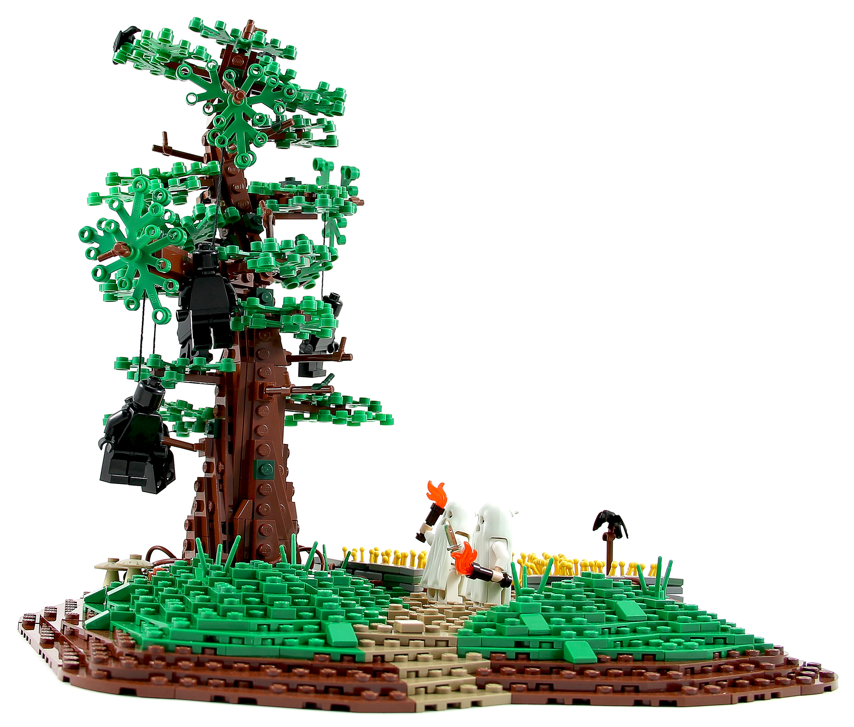
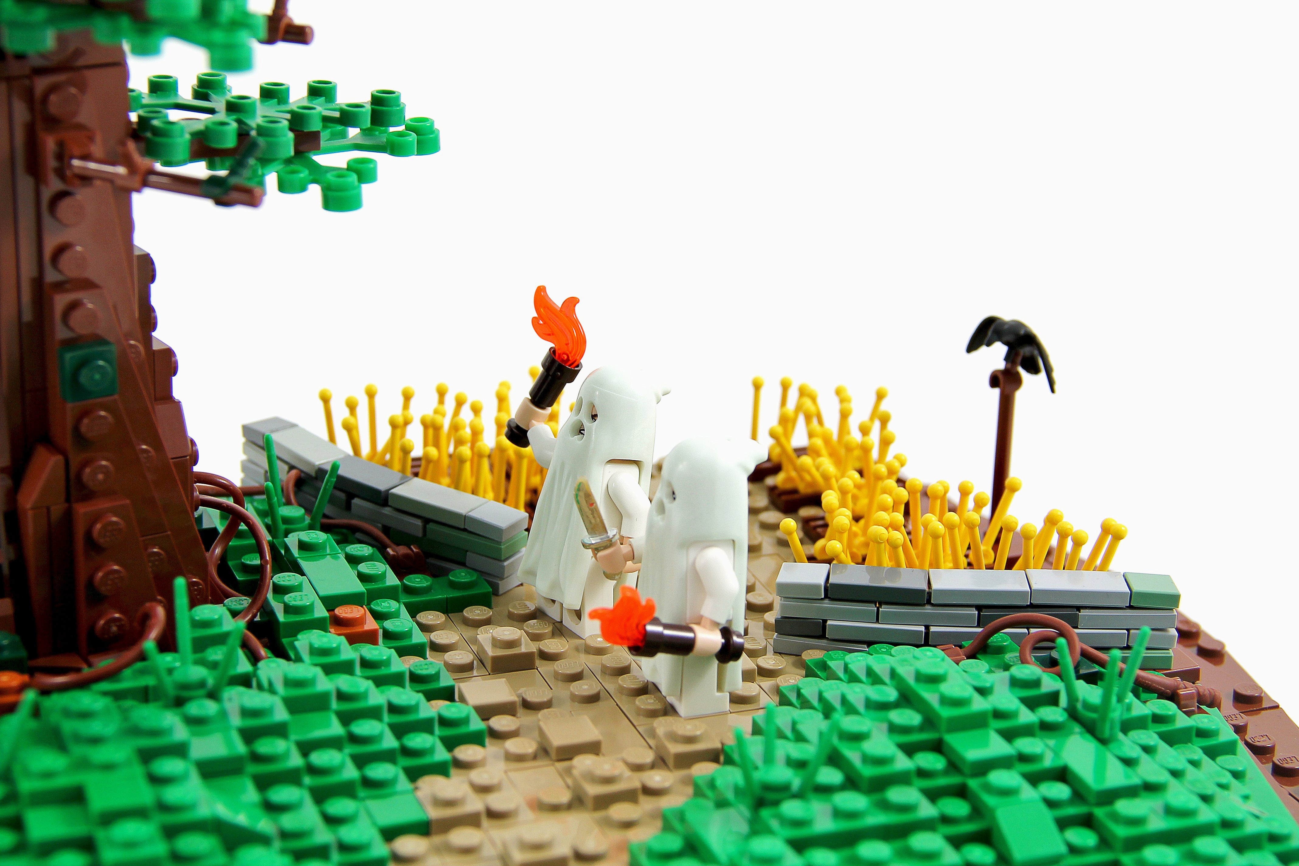
Inukshuk discovers another of his girlfriend Nikita's multiple G-spots.
(9 Photos.)
'Aww how sweet... Thank you little girl...'
'mumblemumblemumble'
'Speak up Lilly!, how we practised!!'
'...mumblese Sir, these flowers mumblemumble...'
**********************************
See the Castle Chronicle Album for all in the right order.
Zu Schloss Biesdorf, dessen bekannteste Bewohner die Familie Siemens war, gehörte ein großes Landgut, das sich unterhalb des erhöht gelegenen Schlosses befand. 'Dort wurde nicht nur Landwirtschaft betrieben, sondern dort gab es am Anfang des 20. Jahrhunderts auch die erste drhbare Luftschiffhalle zu Lande, wo Siemens Luftschiffe testete. Diese musste nach dem 1. Weltkrieg gemäß den Bestimmungen des Versailler Vertrags abgerissen werden, weshalb man keine Spuren davon mehr sieht. In den 1950-er Jahren wurde die landwirtschaftliche Nutzung aufgegeben. Jetzt nähert sich auf dem einstigen Gutsgelände ein neues Wohngebiet mit 515 Wohnungen, genannt "Gut Alt-Biesdorf", seiner Vollendung. Gesellschaftliches Zentrum der Anlage soll der historische Kuhstall werden, der zur Zeit noch restauriert wird. Auch die beiden noch erhaltenen anderen Gutsgebäude sollen restauriert werden und neue Funktionen erhalten.
Biesdorf Manor, whose best-known residents were the Siemens family, included a large estate located below the elevated castle. Not only was agriculture practised there, but at the beginning of the 20th century there was also the first revolving airship hangar on land, where Siemens tested airships. This had to be demolished after World War I in accordance with the provisions of the Treaty of Versailles, which is why you can no longer see any traces of it. In the 1950s, agricultural use was abandoned. Now a new residential area with 515 flats is nearing completion on the former estate grounds, called "Old Biesdorf Estate". The social centre of the complex is to be the historic cowshed, which is currently still being restored. The two other remaining estate buildings are also to be restored and given new functions.
This resivoir appears in the film the Dambusters and the next resivoir up is the derwent dam were the Dambusters practised before the real thing
en.wikipedia.org/wiki/Punjab_(region)
The Punjab (Listeni/pʌnˈdʒɑːb/, /ˈpʌndʒɑːb/, /pʌnˈdʒæb/, /ˈpʌndʒæb/), also spelled Panjab, panj-āb, land of "five rivers"[1] (Punjabi: پنجاب (Shahmukhi); ਪੰਜਾਬ (Gurumukhi)), is a geographical and cultural region in the northern part of South Asia, comprising areas of eastern Pakistan and northern India. Not being a political unit, the extent of the region is the subject of debate and focuses on historical events to determine its boundaries.
The Punjab region has been inhabited by Indus Valley Civilisation, Indo-Aryan peoples, Indo-Scythians and has seen numerous invasions by the Achaemenid Empire, Greeks, Kushan Empire, Ghaznavids, Timurids, Mughals, Afghans, British and others. The foreign invaders mainly targeted the most productive region of Punjab known as the Majha region,[2] located in central part of Punjab, which is also the bedrock of Panjabi culture and traditions.[3] The people of the Punjab today are called Punjabis and their principal language is called Punjabi. The main religions of the Punjab region are Islam, Sikhism and Hinduism. Other religious groups are Christianity, Jainism and Buddhism.
Etymology
History
The name of the region is a compound of two Persian words[1][4] Panj (five) and āb (water) and was introduced to the region by the Turko-Persian conquerors[5] of India and more formally popularised during the Mughal Empire.[6][7] Punjab literally means "(The Land of) Five Waters" referring to the rivers: Jhelum, Chenab, Ravi, Sutlej, and Beas.[8] All are tributaries of the Indus River, the Chenab being the largest.
Physical geography
There are two main definitions of the Punjab region: the 1947 definition and the older 1846-1849 definition. The third definition incorporates both the 1947 and the older definitions but also includes northern Rajasthan on a linguistic basis and ancient river movements.
1947 definition
The 1947 definition defines the Punjab region with reference to the dissolution of British India whereby the then British Punjab Province was partitioned between India and Pakistan. In Pakistan, the region now includes the Punjab province and Islamabad Capital Territory. In India, it includes the Punjab state, Chandigarh, Haryana[9] and Himachal Pradesh.
Using the 1947 definition, the Punjab region borders Kashmir to the north, Sindh and Rajasthan to the south, the Pashtun region and Balochistan to the west, and the Hindi belt to the east. Accordingly, the Punjab region is very diverse and stretches from the hills of the Kangra Valley to the plains and to the Cholistan Desert.
Major cities
sing the 1947 definition of the Punjab region, some of the major cities of the area include Lahore, Faisalabad and Ludhiana.
The older definition of the Punjab region focuses on the collapse of the Sikh Empire and the creation of the British Punjab province between 1846 and 1849. According to this definition, the Punjab region incorporates, in Pakistan, Azad Kashmir including Bhimber and Mirpur[10] and parts of Khyber Pakhtunkhwa (especially Peshawar[11][12] known in the Punjab region as Pishore).[13] In India the wider definition includes parts of Delhi and Jammu Division.[14][15]
Using the older definition of the Punjab region, the Punjab region covers a large territory and can be divided into five natural areas:[1]
the eastern mountainous region including Jammu Division and Azad Kashmir;
the trans-Indus region including Peshawar;
the central plain with its five rivers;
the north-western region, separated from the central plain by the Salt Range between the Jhelum and the Indus rivers;
the semi-desert to the south of the Sutlej river.
The formation of the Himalayan Range of mountains to the east and north-east of the Punjab is the result of a collision between the north-moving Indo-Australian Plate and the Eurasian Plate. The plates are still moving together, and the Himalayas are rising by about 5mm per year.
The upper regions are snow-covered the whole year. Lower ranges of hills run parallel to the mountains. The Lower Himalayan Range runs from north of Rawalpindi through Jammu and Kashmir, Himachal Pradesh and further south. The mountains are relatively young, and are eroding rapidly. The Indus and the five rivers of the Punjab have their sources in the mountain range and carry loam, minerals and silt down to the rich alluvial plains, which consequently are very fertile.[16]
Major cities
According to the older definition, some of the major cities include Jammu, Peshawar and parts of Delhi.
Greater Punjab
The third definition of the Punjab region adds to the definitions cited above and includes parts of Rajasthan[17][18][19][20] on linguistic lines and taking into consideration the location of the Punjab rivers in ancient times. In particular, the Sri Ganganagar and Hanumangarh districts are included in the Punjab region.
Climate
The climate is a factor contributing to the economy of the Punjab. It is not uniform over the whole region, with the sections adjacent to the Himalayas receiving heavier rainfall than those at a distance.[22]
There are three main seasons and two transitional periods. During the Hot Season, from about mid April to the end of June, the temperature may reach 49˚C. The Monsoon Season, from July to September, is a period of heavy rainfall, providing water for crops in addition to the supply from canals and irrigation systems. The transitional period after the monsoon is cool and mild, leading to the Winter Season, when the temperature in January falls to 5˚C at night and 12˚C by day. During the transitional period from Winter to the Hot Season sudden hailstorms and heavy showers may occur, causing damage to crops.[23]
History
The Punjab region of India and Pakistan has a historical and cultural link to Indo-Aryan peoples as well as partially to various indigenous communities. As a result of several invasions from Central Asia and the Middle East, many ethnic groups and religions make up the cultural heritage of the Punjab.
In prehistoric times, one of the earliest known cultures of South Asia, the Indus Valley Civilisation was located in the region.
The epic battles described in the Mahabharata are described as being fought in what is now the present-day State of Haryana and historic Punjab. The Gandharas, Kambojas, Trigartas, Andhra, Pauravas, Bahlikas (Bactrian settlers of the Punjab), Yaudheyas and others sided with the Kauravas in the great battle fought at Kurukshetra.[24] According to Dr Fauja Singh and Dr L. M. Joshi: "There is no doubt that the Kambojas, Daradas, Kaikayas, Andhra, Pauravas, Yaudheyas, Malavas, Saindhavas and Kurus had jointly contributed to the heroic tradition and composite culture of ancient Punjab".[25]
Menander I Soter (165/155 –130 BC) conqueror of the Punjab, he carved out a Greek kingdom in the Punjab and ruled the Punjab till his death in 130 B.C.[26][27]
In 326 BCE, Alexander the Great invaded the tip of the Punjab from the north (present-day Khyber Pakhtunkhwa in Pakistan) and defeated King Porus. His armies entered the region via the Hindu Kush in northwest Pakistan and his rule extended up to the city of Sagala (present-day Sialkot in northeast Pakistan). In 305 BCE the area was ruled by the Maurya Empire. In a long line of succeeding rulers of the area, Chandragupta Maurya and Ashoka stand out as the most renowned. The Maurya presence in the area was then consolidated in the Indo-Greek Kingdom in 180 BCE. Menander I Soter "The Saviour" (known as Milinda in Indian sources) is the most renowned leader of the era, he conquered the Punjab and made Sagala the capital of his Empire.[26] Menander carved out a Greek kingdom in the Punjab and ruled the region till his death in 130 B.C.[27] The neighbouring Seleucid Empire rule came to an end around 12 BCE, after several invasions by the Yuezhi and the Scythian people.
In 711–713 CE, 18-year-old Arab Sultan Muhammad bin Qasim of Taif, a city in what is now Saudi Arabia, came by way of the Arabian Sea with Arab troops to defeat Raja Dahir. The Sultan then led his troops to conquer the Sindh and Punjab regions for the Islamic Umayyad Caliphate. Qasim was the first to bring Islam to the region.
A section of the Lahore Fort built by the Mughal emperor Akbar.
During the establishment and consolidation of the Muslim Turkic Mughal Empire prosperity, growth, and relative peace were established. Particularly under the reign of Jahangir. Muslim empires ruled the Punjab for approximately 1000 years. The period was also notable for the emergence of Guru Nanak (1469–1539), the founder of Sikhism.
In 1758, Punjab came under the rule of Marathas who captured the region by defeating Afghan forces of Ahmad Shah Abdali. Abdali's Indian invasion weakened the Maratha influence, but he could not defeat the Sikhs. After the death of Ahmad Shah, the Punjab was freed from the Afghan yoke by Sikhs between 1773 and 1818. At the time of the formation of the Dal Khalsa in 1748 at Amritsar, the Punjab had been divided into 36 areas and 12 separate Sikh principalities, called misl. From this point onward, the beginnings of a Punjabi Sikh Empire emerged. Out of the 36 areas, 22 were united by Maharaja Ranjit Singh. The other 14 accepted British sovereignty. After Ranjit Singh's death, assassinations and internal divisions severely weakened the empire. Six years later the British East India Company was given an excuse to declare war and in 1849, after two Anglo-Sikh wars, the Punjab was annexed by the British.
In the Indian Rebellion of 1857 the Sikh rulers backed the East India Company, providing troops and support,[28] but in Jhelum 35 British soldiers of HM XXIV regiment were killed by the local resistance and in Ludhiana a rebellion was crushed with the assistance of the Punjab chiefs of Nabha and Malerkotla.
The British Raj had political, cultural, philosophical and literary consequences in the Punjab, including the establishment of a new system of education. During the independence movement, many Punjabis played a significant role, including Madan Lal Dhingra, Sukhdev Thapar, Ajit Singh Sandhu, Bhagat Singh, Udham Singh, Kartar Singh Sarabha, Bhai Parmanand, Muhammad Iqbal, Chaudhary Rehmat Ali, and Lala Lajpat Rai.
At the time of partition in 1947, the province was split into East and West Punjab. East Punjab (48%) became part of India, while West Punjab (52%) became part of Pakistan.[29] The Punjab bore the brunt of the civil unrest following the British Raj, with casualties estimated to be in millions.
Timeline
3300–1500 BCE: Harappan civilisation
1500–1000 BCE: (Rigvedic) Vedic civilisation
1000–500 BCE: Middle and late Vedic Period
599 BCE: Birth of Mahavira
567–487 BCE: Time of Gautama Buddha
550 BCE – 600 CE: Buddhism remained prevalent
326 BCE: Alexander's Invasion of Punjab
322–298 BCE: Chandragupta I, Maurya period
273–232 BCE: Reign of Ashoka
125–160 BCE: Rise of the Sakas
2 BCE: Beginning of Rule of the Sakas
45–180: Rule of the Kushans
320–550: Gupta Empire
500: Hunnic Invasion
510–650: Vardhana's Era
711–713: Muhammad bin Qasim conquers Sindh and small part of Punjab region
713–1200: Rajput states, Kabul Shahi & small Muslim kinddoms
1206–1290: Mamluk dynasty established by Mohammad Ghori
1290–1320: Khilji dynasty established by Jalal ud din Firuz Khilji
1320–1413: Tughlaq dynasty established by Ghiyasuddin Tughlaq
1414–1451: Sayyid dynasty established by Khizr Khan
1451–1526: Lodhi dynasty established by Bahlul Khan Lodhi
1469–1539: Guru Nanak
1526–1707: Mughal rule
1526–1530: Zaheeruddin Muhammad Babur
1530–1540: Nasiruddin Muhammad Humayun
1540–1545: Sher Shah Suri of Afghanistan
1545–1554: Islam Shah Suri
1555–1556: Nasiruddin Muhammad Humayun
1556–1556: Hem Chandra Vikramaditya
1556–1605: Jalaluddin Muhammad Akbar
1605–1627: Nooruddin Muhammad Jahangir
1627–1658: Shahaabuddin Muhammad Shah Jahan
1658–1707: Mohiuddin Muhammad Aurangzeb Alamgir
1539–1675: Period of 8 Sikh Gurus from Guru Angad Dev to Guru Tegh Bahadur
1675–1708: Guru Gobind Singh (10th Sikh Guru)
1699: Birth of the Khalsa
1708–1713: Conquests of Banda Bahadur
1722: Birth of Ahmed Shah Durrani, either in Multan in Mughal Empire or Herat in Afghanistan
1714–1759: Sikh chiefs (Sardars) war against Afghans & Mughal Governors
1739: Invasion by Nader Shah and defeat of weakened Mughal Empire
1747–1772: Durrani Empire led by Ahmad Shah Durrani
1756–1759: Sikh and Maratha Empire cooperation in the Punjab
1761: The Third Battle of Panipat, between the Durrani Empire against the Maratha Empire.
1762: 2nd massacre (Ghalughara) from Ahmed Shah's 2nd invasion
1765–1801: Rise of the Sikh Misls which gained control of significant swathes of Punjab
1801–1839: Sikh Empire also known as Sarkar Khalsa, Rule by Maharaja Ranjit Singh
1845–1846: First Anglo-Sikh War
1846: Jammu joined with the new state of Jammu and Kashmir
1848–1849: Second Anglo-Sikh War
1849: Complete annexation of Punjab into British India
1849–1947: British rule
1901: Peshawar and adjoining districts separated from the Punjab Province
1911: Parts of Delhi separated from Punjab Province
1947: The Partition of India divided Punjab into two parts. The Eastern part (with two rivers) became the Indian Punjab and the Western part (three rivers) the Pakistan Punjab
1966: Indian Punjab divided into three parts: Punjab, Haryana, and Himachal Pradesh
1973–1995: Punjab insurgency
1986: Resolution by militants proposing an independent state of Khalistan
People of the Punjab
Ethnic ancestries of modern Punjabis include a mixture of Indo-Aryan and Indo-Scythian. Semitic ancestries can also be found in lesser numbers. With the advent of Islam, settlers from Turkestan, Afghanistan, and Kashmir have also integrated into the Muslim Punjabi society. However the majority of Punjab is still made up of the Ahirs, Arains, Dalits (mostly Chamars), Gujjars, Jats, Khatris, Tarkhans, Brahmins, Bhats, Rajputs, Rors and Saini. In the past, the most densely populated area has been the Majha region of Punjab.
Languages
The major language spoken in the Punjab is Punjabi. In the Indian Punjab this is written in the Gurmukhi script. Pakistan uses the Shahmukhi script, that is closer to Urdu script. Hindi, written in the Devanagri script, is used widely in the Indian states of Himanchal Pradesh and Haryana. Several dialects of Punjabi are spoken in the different regions. The Majhi dialect is considered to be textbook Punjabi and is shared by both countries.
Religions
The vast majority of Pakistani Punjabis are Sunni Muslim by faith, but also include large minority faiths mostly Shia Muslim, Ahmadi Muslim and Christians.
The Indian states of Haryana and Himachal Pradesh are mostly Hindu-majority. Sikhism, founded in the late 15th century, is the main religion practised in the post-1966 Indian Punjab state. About 60% of the population of Punjab state is Sikh, 37% is Hindu, and the rest are Muslims, Christians, and Jains.[30] However, due to large scale migration from Uttar Pradesh, Rajasthan, Bihar, Bengal and Odisha the demographics have become more skewed than reported earlier. Punjab state contains the holy Sikh city of Amritsar.
The Punjab was home to several Sufi saints.[31] Sufism is a concept in Islam. Also, Kirpal Singh revered the Sikh Gurus as saints.
Punjabi festivals
Punjabis celebrate the following cultural, seasonal and religious festivals:
Maghi
Lohri
Holi
Vaisakhi
Teeyan
Raksha Bandhan
Mela Chiraghan
Diwali
Dussehra
Karwa Chauth
Eid
Christmas
Navratri
Punjabi clothing
Traditional Punjabi clothing includes the following:
Salwar (Punjabi) Suit
Patiala salwar
Punjabi Tamba and Kurta
Phulkari
Punjabi Ghagra
Shalwar kameez
Kurta
Economy
Main articles: Economy of Punjab, Pakistan and Economy of Punjab, India
The historical region of Punjab is considered to be one of the most fertile regions on Earth. Both east and west Punjab produce a relatively high proportion of India and Pakistan's food output respectively.
The region has been used for extensive wheat farming, in addition rice, cotton, sugarcane, fruit and vegetables are also grown.
The agricultural output of the Punjab region in Pakistan contributes significantly to Pakistan's GDP. Both Indian and Pakistani Punjab are considered to have the best infrastructure of their respective countries. Indian Punjab has been estimated to be the second richest state in India.[34] Pakistani Punjab produces 68% of Pakistan's food grain production.[35] Its share of Pakistan's GDP has historically ranged from 51.8% to 54.7%.[36]
Called "The Granary of India" or "The Bread Basket of India", Indian Punjab produces 1% of the world's rice, 2% of its wheat, and 2% of its cotton.[37] In 2001, it was recorded that farmers made up 39% of Indian Punjab's workforce.
The caber toss is a traditional Scottish athletic event in which competitors toss a large tapered pole called a "caber" It is normally practised at the Scottish Highland Games. In Scotland, the caber is usually made from a larch tree, and it can be between 16–20 feet (5–6 metres) tall and weigh 90–150 pounds (40–70 kilograms). The person tossing the caber is called a "tosser" or a "thrower"
The primary objective is to toss the caber so that it turns end over end, falling away from the tosser. Ideally it should fall directly away from the tosser in the "12 o'clock" position. The distance thrown is unimportant.
The tosser balances the caber upright, tapered end downwards, against his or her shoulder and neck, the caber being supported by stewards or fellow-competitors while being placed into position. The tosser then crouches, sliding their interlocked hands down the caber and under the rounded base, and lifts it in their cupped hands. The tosser must balance the caber upright; this is not easy with the heavier end at the top, and less-experienced tossers may be unable to stop the caber falling to one side after lifting it. The tosser then walks or runs a few paces forward to gain momentum, and flips the tapered end upwards so that the large end hits the ground first, and, if well tossed, the caber falls directly away from the tosser. Weight and strength are essential for success, but technique is also important for balancing the caber when lifting it, and flipping up the held (tapered) end to promote a clean toss.
The straightest end-over-end toss scores highest. If the caber lands on its end but falls back towards the thrower, the score is lower than for any end-over-end throw
This afternoon I went round to Tracey's for a gorgeous cream tea type afternoon. I have eaten enough to last me until at least Christmas Day! Whilst there, I practised some Lensbaby creative aperture shots on her Christmas tree. I really need to use my Lensbaby more, as I love what it can do.
Thanks for a lovely afternoon, T! xx
Info: Canon 550D, Lensbaby Composer Pro with Double Glass Optic and various creative apertures. 1/80 second, ISO 2500.
Winkworth Arboretum exhibits large collections of azalea, rhododendron, and holly on slopes leading down to landscaped garden lakes. Gertrude Jekyll explored the woods in the early 20th century. The exotic trees were planted from 1938 by Wilfrid Fox.
Wilfrid Fox (1875–May 22, 1962[1]) was a dermatologist in the United Kingdom.[2] He practised at St George's Hospital, London.
He became passionately interested in the environment.[citation needed] He founded the Roads Beautifying Association in 1928. wikipedia
He lived at Winkworth Farm, Busbridge, Surrey. In 1937, he acquired part of the adjoining Thorncombe Estate, and proceeded to create an arboretum.[citation needed]
In 1948, he was awarded the highest honour of the Royal Horticultural Society, the Victoria Medal of Honour. He gave part of the arboretum to the National Trust in 1952, and the trust later acquired more of the land. This is now open to the public as Winkworth Arboretum.[
Saw on YouTube how you could do a circular intentional camera movement, so I practised in the backyard.
I like this road scene. I was attracted by the sun rolling over the fields opposite, farming has been practised on these chalk hills for centuries, including by my grandmother's family. But we were walking down a much older and much more mysterious path, West Kennet Avenue, an double row of Neolithic standing stones that lead from the circles at Avebury to the Sanctuary to the south. And the road? Well that provided another side to Wiltshire, the modern one. England
The Hagen Open-air Museum (LWL-Freilichtmuseum Hagen – Westfälisches Landesmuseum für Handwerk und Technik; English: "LWL Open-air Museum Hagen – Westphalian State Museum for Craft and Technics") is a museum at Hagen in the southeastern Ruhr area, North Rhine-Westphalia, Germany. It was founded, together with the Detmold Open-air Museum, in 1960, and was first opened to the public in the early 1970s. The museum is run by the Landschaftsverband Westfalen-Lippe (LWL, regional authority for Westphalia and Lippe within North Rhine-Westphalia). It lies in the Hagen neighbourhood of Selbecke south of Eilpe in the Mäckingerbach valley.
The open-air museum brings a bit of skilled-trade history into the present, and it takes a hands-on approach. On its grounds stretching for about 42 ha, not only are urban and rural trades simply "displayed" along with their workshops and tools, but in more than twenty of the nearly sixty rebuilt workshops, they are still practised, and interested visitors can, sometimes by themselves, take part in the production.
As early as the 1920s, there were efforts by a group of engineers and historical preservationists to preserve technological monuments for posterity. The initiator, Wilhelm Claas, even suggested the Mäckingerbach valley as a good place for a museum to that end. The narrow valley was chosen, as wind, water and wood were the three most important location factors for industry in the 18th and 19th centuries.
In 1960, the Westphalian Open-Air Museum was founded, and thirteen years later, the gates opened to the public. Unlike most open-air museums, which show everyday life on the farm or in the country as it was in days gone by, the Hagen Open-Air Museum puts the history of these activities in Westphalia in the fore. From the late 18th century through the early years of the Industrial Revolution to the highly industrialized society emerging in the early 20th century, the visitor can experience the development of these trades and the industry in the region.
Crafts and trades demonstrated at the Westphalian Open-Air Museum include ropemaking, smithing, brewing, baking, tanning, printing, milling, papermaking, and much more. A favourite attraction is the triphammer workshop shown in the image above. Once the hammer is engaged, a craftsman goes to work noisily forging a scythe, passing it between the hammer and the anvil underneath in a process called peening.
The Hagen Westphalian Open-Air Museum is open from March or April until October.
Another shot taken during the recent Action Photography workshop with Tom Miles ( www.tmphoto.co.uk/ ) and three parkour experts.
Having been selected as one of 100 photographers to take part in the #Nikon100 Centenary #Nikonmeetups the day involved five seperate themed shoots around different locations in London. All in all it was a superbly organised event and I captured a wide variety of shots.
Click here to see my other shots from the days workshops : www.flickr.com/photos/darrellg/albums/72157686756184653
From Wikipedia : "Parkour (French pronunciation: [paʁkuʁ]) is a training discipline using movement that developed from military obstacle course training. Practitioners aim to get from one point to another in a complex environment, without assistive equipment and in the fastest and most efficient way possible. Parkour includes running, climbing, swinging, vaulting, jumping, rolling, quadrupedal movement, and other movements as deemed most suitable for the situation. Parkour's development from military training gives it some aspects of a non-combative martial art.
Parkour is an activity that can be practised alone or with others and is usually—but not exclusively—carried out in urban spaces. Parkour involves seeing one's environment in a new way, and imagining the potential for navigating it by movement around, across, through, over and under its features.
Parkour was developed in France, primarily by Raymond Belle, and further by his son David and the latter's group of friends, the self-styled Yamakasi, during the late 1980s. The discipline was popularised in the late 1990s and 2000s through films, documentaries, and advertisements featuring the Yamakasi."
My Website : Twitter : Facebook : Instagram : Photocrowd
© D.Godliman
One of the four forms of bullfighting praticed in the world but it differs from the other three by two features, first it is practised exclusevely with cows and not bulls, the other feature it shares with the Camargue races, is that there is no killing, or hurting of the animal, either during the race, or after.
We recently visited a dairy farm in Germany where there was a gorgeous farm dog/family pet named Joy. When the dairy talk became a bit technical for me I sidled over and made friends with Joy; soon she was posing for my camera and was prepared to run up and down for me while I practised capturing moving objects.
I've made friends with a lot of farm dogs in Australia and overseas and Joy will always stand out as one of the happiest.
The transhumance shepherds start their season in April when the better weather starts, lower in the valleys close to villages. This is their muster point, where villagers take their individual sheep to the shepherds to graze until October. Once they have gathered all the sheep for the season they then move into the forested hills to rich grazing on inter-forest meadows. The shepherds will look after these sheep, feed and care for them, milk them 2-3 times day and shear their wool. Each villager will take a share of the milk or cheese produced depending on the number of sheep they have with the shepherds. Life is tough for the shepherds and their dogs as they live outdoors with the sheep, protecting them from the constant threat of wolf and bear depredation. This sustainable method of food and wool production has been practised for hundreds of years and little has changed to this day.
I thought I would provide a moment of respite from Outback photos with this image of Mrs. Wingman when the pair of them arrived this morning. It was a bit foggy but no rain but it seems she was up early exploring for food around the dewy grass and local creeks. Mr. W was perfectly coifed!
We are waiting to meet Mr and Mrs W's new 2024 brood. Since late August, this couple have been arriving separately (a behaviour not otherwise practised) and that went on for quite a few weeks. Now they are back to coming together but up to four times a day (usual appearances are 0-2 times a day) so we are fairly confident that they have a hungry family somewhere not too far away.
She will clean up but he will have to work hard at preening her. Hard work being Dads and Mums!
Let me confess two difficulties of mine. Number one: I am often afraid of God-talk as practised by theologians and preachers. Not only because it can sound predictable and tired, almost like a dead language. More seriously, it can put the cart before the horse. It can lead people to think of God as a Big Object out there beyond us. But God is utterly close to us and yet silent, wanting to lead us to the Love that became humanly real for us in Christ. We could be looking in the wrong direction for the wrong god.
And here is my second difficulty: for the vast majority of humanity who have lived on this planet for thousands of years, a fullness of Christian faith was not possible. Even for the baptised and believing, I am convinced that our main contact with God is through a quiet grace that guides us through each ordinary day, rather than through explicit moments of religious awareness. What flowers into the fullness of Christian faith has its roots within us long before we come to hear the Word of revelation. Before the Word reaches its climax in the Gospel, the Spirit was already at work in all humanity, all cultures, all religions.
So too in each of us: the Spirit is always leading us towards an encounter with Christ, even though we are unaware of that guidance. We can notice the fruits even when we do not name the roots. That is why I encourage you to become aware of the direction of the river of your life. In spite of egoism and closure, you can recognise your yearning for goodness, and your living out of goodness in the concrete life of each day. In spite of shadows and refusals, you can become more open to love, passionate about truth, courageous in difficulties, generous in attitudes and actions, even surprisingly serene in the face of death itself.
-FAITH MAPS Ten religious explorers from Newman to Joseph Ratzinger Michael Paul Gallagher SJ, chapter 3:
Karl Rahner: the magnetism of mystery
We stayed with this family of two juvenile cheetahs plus mother, anticipating some action, as they strolled across the plains. They stumbled upon and caught this unfortunate scrub hare, seen here already maimed, and practised their hunting skills. Note that its ear is chewed.
Mauritius, officially the Republic of Mauritius, is an island nation in the Indian Ocean about 2,000 kilometres off the southeast coast of the African continent, east of Madagascar. It includes the main island (also called Mauritius), as well as Rodrigues, Agaléga and St. Brandon. The islands of Mauritius and Rodrigues, along with nearby Réunion (a French overseas department), are part of the Mascarene Islands. The capital and largest city, Port Louis, is located in Mauritius, where most of the population is concentrated. The country spans 2,040 square kilometres and has an exclusive economic zone covering 2.3 million square kilometres.
Arab sailors were the first to discover the uninhabited island, around 975, and they called it Dina Arobi. The earliest confirmed discovery was in 1507 by Portuguese sailors, who otherwise took little interest in the islands. The Dutch took possession in 1598, establishing a succession of short-lived settlements over a period of about 120 years, before abandoning their efforts in 1710. France took control in 1715, renaming it Isle de France. In 1810, the island was seized by Great Britain, and four years later France ceded Mauritius and its dependencies to Britain. As a British colony, Mauritius included Rodrigues, Agaléga, St. Brandon, Tromelin, the Chagos Archipelago, and, until 1906, the Seychelles. Sovereignty over Tromelin is disputed between Mauritius and France, as it was not specifically mentioned in the Treaty of Paris. Mauritius remained a primarily plantation-based colony of the United Kingdom until independence in 1968.
In 1965, three years before Mauritius became independent, the UK split off the Chagos Archipelago from Mauritian territory, and also split off the islands of Aldabra, Farquhar, and Desroches from the Seychelles, to form the British Indian Ocean Territory (BIOT). The local population was forcibly expelled and the largest island, Diego Garcia, was leased to the United States. The UK has restricted access to the Chagos Archipelago, barring entry to casual tourists, the media, and former inhabitants. The sovereignty of the Chagos is disputed between Mauritius and the UK. In February 2019, the International Court of Justice issued an advisory opinion ordering the UK to return the Chagos Islands to Mauritius as rapidly as possible to complete the decolonisation of Mauritius.
Owing to its geographic location and centuries of colonialism, the people of Mauritius are highly diverse in ethnicity, culture, language and faith. It is the only country in Africa where Hinduism is the most practised religion. The island's government is closely modelled on the Westminster parliamentary system, and Mauritius is highly ranked for democracy and for economic and political freedom. Mauritius is the only African country to be in the "very high" category on the Human Development Index. According to the World Bank, the country is classified as a high-income economy. Mauritius is also ranked as the most competitive, and one of the most developed economies in the African region. The country is a welfare state. The government provides free universal healthcare, free education up through the tertiary level and free public transportation for students, senior citizens, and the disabled. In 2019, Mauritius was ranked the most peaceful African country by the Global Peace Index.
Along with the other Mascarene Islands, Mauritius is known for its varied flora and fauna. Many species are endemic to the island. The island was the only known home of the dodo, which, along with several other avian species, was made extinct by human activities relatively soon after the island's settlement.
"Remember remember the fifth of November
Gunpowder, treason and plot.
I see no reason why gunpowder, treason
Should ever be forgot..."
This wonderful little Church of St Andrew in Stoke Dry in the County of Rutland has a wonderful and interesting history.
There is loads to see here with the 13th Century building having some great Norman bits. The walls have some cracking wall paintings and one in particular has scholars puzzled as it seems to show American Indians peppering St Edmund with arrows centuries before Columbus stumbled across that little place across the pond, if people are interested I will post the wall at a later date (it really does look like an American Indian).
There are also interesting links to the Gunpowder plot as The Everard family owned Stoke Dry and Everard (silly name) was executed for his part in the plot. One of the rumours is that plot meetings were held in the Parvis above the Churches entrance.
All in all a great Church to visit and right next to Eyebrook reservoir where the bouncing bomb runs were practised.
Happy Sunday one and all.
Mark x
Kyūdō is the Japanese martial art of archery. Experts in kyūdō are referred to as kyūdōka (弓道家). Kyūdō is based on kyūjutsu ("art of archery"), which originated with the samurai class of feudal Japan. Kyūdō is practised by thousands of people worldwide. As of 2005, the International Kyudo Federation had 132,760 graded members. (Wikipedia)
The houseboat on the left is the one we stayed in during our 1971 holiday in Oxford! It was rather like staying in a caravan, but I do remember the huge spiders that shared it with us!! The houseboats were just off Folly Bridge. (Folly Bridge is a stone bridge over the River Thames carrying the Abingdon Road south from the centre of Oxford, England. It was erected in 1825–27, to designs of a little-known architect, Ebenezer Perry (died 1850), who practised in London.)
Now it's a Fullers hotel - The Head of the River.
(Both photos from my Dad's collection of slides)
The caber toss is a traditional Scottish athletic event in which competitors toss a large tapered pole called a "caber". Here it is being practised at the Arisaig Highland Games. The caber is usually made from a larch tree and it can be between 16–20 feet (4.9–6.1 m) tall and weighs between 90–150 pounds (6.4–10.7 st; 41–68 kg). The term "caber" derives from the Gaelic word cabar, which refers to a wooden beam. The person tossing the caber is called a "tosser" or a "thrower".
It is said to have developed from the need to toss logs across narrow chasms (in order to cross them). I do it all the time when I'm out in the wilds.
The primary objective is to toss the caber so that it turns end over end, falling away from the tosser. Ideally it should fall directly away from the tosser in the "12 o'clock" position. The distance thrown is unimportant.
The tosser balances the caber upright, tapered end downwards, against his or her shoulder and neck, the caber being supported by stewards or fellow-competitors while being placed into position. The tosser then crouches, sliding their interlocked hands down the caber and under the rounded base, and lifts it in their cupped hands. The tosser must balance the caber upright; this is not easy with the heavier end at the top, and less-experienced tossers may be unable to stop the caber falling to one side after lifting it. The tosser then walks or runs a few paces forward to gain momentum, and flips the tapered end upwards so that the large end hits the ground first, and, if well tossed, the caber falls directly away from the tosser.
Weight and strength are essential for success, but technique is also important for balancing the caber when lifting it, and flipping up the held (tapered) end to promote a clean toss
The straightest end-over-end toss scores highest. If the caber lands on its end but falls back towards the thrower, the score is lower than for any end-over-end throw but is based upon the maximum vertical angle that the caber achieved (side-judging may involve a second judge).
End-over-end tosses are scored according to the hours on a clock, with a 12:00 score being highest (falling directly away from the thrower), down to a 9 or 3 for cabers that reach a vertical, before falling to the side.
This chap (didn't catch his name) made an excellent toss here with the caber going end over and landing pointing directly away from him for a maximum score. And that was a hefty caber too. Scrutineers may judge he had a secret weapon up his kilt.
The Château de Puivert is a so-called Cathar castle situated in the commune of Puivert, in the Aude département of France. This building, on top of a hill overhanging the village and its lake, reaches an altitude of 605 m. The site is in the Quercob region, 60 km (37 mi) south of Carcassonne and 45 km (28 mi) east of Foix. The castle has been listed as a monument historique by the French Ministry of Culture since 1902.
The construction of the present chateau dates from the 13th century. The first mention is in 1170; it belonged to the Congost family before the Albigensian Crusade. These lords practised Catharism and were accused as heretics. Then, in November 1210, the castle was subjected for three days to a siege by the army of Thomas Pons de Bruyère, lieutenant of Simon de Montfort. The castle subsequently became the property of the northern barons. All that is left of this older castle is a few sections of wall to the east. A collapse of the natural dam on the lake at the foot of the site caused the destruction of part of the town of Mirepoix, 30 km to the north, in Ariège in 1279. According to legend, this was because a certain Dame Blanche wanted to daydream on the lake shores, which were inaccessible in bad weather. She asked that the water level be lowered and work undertaken to accomplish this goal led to the collapse.
In the heart of Tam Coc, a spectacle unfolds that is as mesmerising as the landscape itself - rowers who navigate their boats with the strength and precision of their feet. 🚣♂️
This frame captures a local figure, his legs dancing over the oars with practised grace. An nón lá, a traditional Vietnamese leaf hat, rests on his head, a symbol of the rich cultural heritage of Vietnam. The simple yet profound emblem stands against the stunning backdrop of limestone karsts, lush rice fields, and tranquil waters.
The foot-rowing technique, a signature of Tam Coc, is a testament to the adaptability and innovation of its people. It allows the rowers to steer through the winding waterways while freeing their hands for other tasks, an aquatic ballet perfected over generations that leaves every visitor enchanted.
Tucked away in Ninh Binh province, Tam Coc, also known as the "inland Ha Long Bay," boasts impressive biodiversity and a rich cultural history. It's a place where the rhythm of rural life merges with spectacular natural beauty to create a symphony of experiences for every traveller.
Through the rustle of the leaves, the rhythmic splash of oars, and the whispering tales of the nón lá, we find the essence of Tam Coc – its enduring traditions, breathtaking beauty, and the indomitable spirit of its people.
There was something about the way the woman swayed gently as she walked towards us across the dimly lit floor of the pub that suggested she was well practised at the art of disguising how much she'd had to drink. Just the slightest hint betrayed the likelihood she'd been to the bar a couple of times more than we had; no more than that. Dave is pretty much teetotal because he says he's allergic to alcohol and only allows himself a single pint of a black stuff when we go to Twickenham for the rugby internationals. I'm not averse to the odd pint, but I can't remember the last time I followed it up with a second one, so while I'd have probably been staggering about in a zig-zag fashion, he'd have been lying face down on the floor and asking to be taken home. In each hand she held a brown paper bag containing a lukewarm pasty, the final leftovers from the gathering. "There's always a few left at the end - I'd have made sure they were all gone earlier than this if I were in charge," she announced with not the slightest hint of a slur. "Here you go." It would serve me well for lunch on Saturday while Ali was at work, I thought. I've no idea who our go-between was, but the pasty was the final present from the man we'd come to say farewell to.
Sometimes, maybe once or twice in a lifetime the sudden departure of a public figure is shared worldwide and everything stands still for a moment or two. We remember exactly where we were, who we were with and what we were doing during the moment frozen in time. Some people I've heard refer to these as the "Kennedy" moments. I wasn't born when the events in Dallas took place, but I remember so clearly waking up at the house of my then in-laws in Preston in the north of England and finding everyone gaping silently at a television set showing a tunnel in Paris with the wreckage of a big black Mercedes dashed against a dark wall. In the 1990's I was in my own tornado blown tunnel, a young father trying to find the best version of himself for his two small children; a young husband struggling to cope with the trials of an already failing marriage; a young man who'd gone wrong somewhere before and now found himself trapped in a dead end job that rewarded little, neither financially nor spiritually. Events in the lives of the great and the good largely passed us by as we did our best to keep our heads above water. There was an interview on the television that gripped the nation, yet we barely registered it; a repeated comment in the office about "three in the marriage right from the start" didn't even raise an eyebrow. And then one afternoon Princess Diana was in Truro, visiting a drug rehabilitation centre just along the road from the firm of land agents where I worked. We stood in the staff car park, dutifully waiting for the entourage to come past. I really wasn't that bothered, but reflected that at least we'd been unchained from our desks for half an hour longer than usual. "What's all the fuss? She's only a square's daughter," boomed the surviving founding partner, a man we thought almost as aristocratic as the royals themselves. I think he meant "squire" rather than "square," but that's how he spoke. Whether he really meant that or it was his attempt at humour I was never certain, but he wasn't impressed that the police had made him park somewhere down the road rather than let him through. Eventually a huge limousine crept along the road past us and for a few fleeting seconds we saw her, and in those moments I was stunned; cast under a spell in fact. I hadn't been prepared for the movie star looks and the smile that almost melted the granite gateposts at the entrance to the car park. I'd like to tell you that for the briefest second I caught her eye, but of course I didn't. Suddenly I understood the mania of the previous fifteen years that until then had completely eluded me. I've never seen another human who exuded such radiance. That smile. It hit me again like a hammer blow on that late summer morning when we heard the news and the country went into mourning. I still see that smile - another frozen moment in fact. Some things just stay with you.
There are other events that only affect a family, or a circle of friends. I was photographing the remains of this Laurel tree after we'd walked down from the freezing cold summit of Pico Ruivo, Madeira's highest mountain when the phone sounded in my pocket. It was Dave with some bad news. Les had been found at his home by the police, who'd had to break in because he wasn't answering anyone's messages. He'd been dead for some time - a heart attack was the culprit it seemed; ironic for a man with such a big heart. Seventy really doesn't seem that old anymore. I'd come to know him through the workplace, and in the wider world during the last few years we moved at the peripheries of a group of friends that he'd grown up with. We hadn't worked directly together, but with someone like Les that didn't matter. Warm, gentle, kind, hilarious and loved by so many of his colleagues he was one of those rare people who transcended the norms of mutual respect in a place that employed well over a thousand staff. In all of the years I worked there, only a tiny number of people seemed to garner such universal approval from their workmates. The students adored him too - he was an IT support tutor - often interrupting my workflow with a spreadsheet problem he wanted me to look at. Because it was Les, I never minded the intrusion. "You're a treasure," he'd always say as I explained my solution to him. People would just smile if you mentioned him. "What's he like?" they would giggle as they remembered something daft he'd said or did just the other day, no doubt that with famous mischievous twinkle in his eye as he did so. Les had a habit of making people feel at ease. One afternoon he appeared at the door of the office I'd just been unwillingly promoted into and found me peering miserably into my screen. "What the f**k you doing in here?" he frowned, before characteristically breaking into a big trademark grin. It was the first time I'd laughed all day. I remembered the time we'd finally managed to persuade him to turn up for a Sunday morning staff football match after years of trying, the first time he'd played in about forty years, so he told us. When he scored a goal there was a bout of unabashed man hugging of the kind usually only reserved for the professional game. We talked about that game for years, long after all the other ones had been mostly forgotten. Dave later told me Les had played at county level as a teenager, and then for a local rugby club well into adulthood. Some of the stories Dave tells about the naughty side of Les from those rugby tours are best left unwritten, no matter how funny they are - besides which I wouldn't do them justice. I never quite get the full thread of exactly what happened because he's always helpless with laughter at the memory well before getting to the end of the anecdote. Sport aside Les was a very gifted artist, winning the school prize every year, always encouraged my burgeoning love for landscape photography. What makes things all the more sad is that he was alone at the end. He wasn't quite as beautiful as the Princess of Wales - almost, but not quite, although a passing resemblance to Paul Newman in his youth was mentioned in the eulogy and he unarguably exuded a certain radiance. His fabled orange perma-tan was legendary among his friends for starters.
The funeral was last week. Dave and Gareth, who'd grown up with him were among the coffin bearers. Henry delivered a moving speech about the "dear sweet boy" who'd made him feel so welcome on his first day at his new school after moving down from Yorkshire and had remained friends with him for more than fifty years. Tim, with tears in his eyes and a contagious lump in his throat faltered through the final lines of "This Is My Cornwall." He only just managed to complete the song. Ali and I, who only knew him for the last twenty years of his life croaked the words to the bits we knew. Friendships that endured a lifetime for those who shared them. In the pub we chewed thoughtfully on pasties and remembered the Les we loved with former colleagues who'd long since retired. And then the lady under the influence weaved towards us with the second round of pasties. It seemed rude not to - especially when Les had sent them to us.
And so it's the memory of Les I will forever cherish whenever I look at this picture and return to that frozen moment; the feeling of emptiness that a dearly held friend and a lovable rogue had gone from the world. This picture will always be his. Ali was silent when I told her what the message said. "He was lovely," she whispered. We barely spoke as we continued our descent, each of us lost in quiet sadness on the lonely mountain path. I'd originally edited this in black and white, but Les was a colourful man. I think he'd have liked the silver and green against the misty mountainside. Rest in peace Les - I'll keep sharing pictures with you mate.
The fishing village of Bolungarvík lies in the bay of the same name and is framed by the prominent mountains Óshyrna, located here above Ósvör, and Tra∂rhyrna, above the village itself.
Because of Bolungarvík's proximity to rich fishing grounds, fishing has been practised from here since the beginning of Iceland's settlement. Fishing huts were built along the coast, but for a long time there was no permanent settlement here. In 1890 a shop was opened in Bolungarvík and gradually people settled here. In 1903 Bolungarvík was officially designated as a trading centre and in 1911 the construction of the harbour began. Fishing is still the most important industry in the village today.
Here in Ósvör you can see how fishing was practised in Bolungarvík and throughout the country in past centuries. Reconstruction of the old fishing huts began in 1988 and today the place looks almost the same as it did in the past.
The Ósvör Museum was built in memory of ways of working that have disappeared in Iceland today. There is a fisherman's hut, a salt house, a fish drying shed, an open rowing boat, a winch and a fish drying area.
Der Fischerort Bolungarvík liegt in der gleichnamigen Bucht und wird von den markanten Bergen Óshyrna, hier oberhalb von Ósvör gelegen, und Tra∂rhyrna, oberhalb des Ortes selbst, eingerahmt.
Wegen der Nähe Bolungarvíks zu den reichen Fischgründen wurde von hier aus schon seit Beginn der Besiedlung Islands Fischerei betrieben. Fischerhütten wurden entlang der Küste errichtet, doch lange Zeit gab es hier keine feste Siedlung. Im Jahr 1890 wurde in Bolungarvík ein Geschäft eröffnet und nach und nach siedelten sich Menschen an. 1903 wurde Bolungarvík offiziell als Handelsplatz ausgewiesen und 1911 begann der Bau des Hafens. Fischerei ist bis heute der wichtigste Wirtschaftszweig des Ortes.
Hier in Ósvör kann man sehen, wie Fischerei in Bolungarvík und im ganzen Land in den vergangenen Jahrhunderten praktiziert wurde. 1988 wurde mit dem Wiederaufbau der alten Fischerhütten begonnen und heute sieht der Ort wieder fast genauso aus wie früher.
Das Museum Ósvör wurde in Erinnerung an heute in Island verschwundene Arbeitsweisen errichtet. Hier gibt es eine Fischerhütte, ein Salzhaus, einen Schuppen zum Trocknen von Fisch, ein offenenes Ruderboot, eine Seilwinde und einen Fischtrockenplatz.
One of the four forms of bullfighting praticed in the world but it differs from the other three by two features, first it is practised exclusevely with cows and not bulls, the other feature it shares with the Camargue races, is that there is no killing, or hurting of the animal, either during the race, or after.
en.wikipedia.org/wiki/Great_cormorant
The great cormorant (Phalacrocorax carbo), known as the great black cormorant across the Northern Hemisphere, the black cormorant in Australia, the large cormorant in India and the black shag further south in New Zealand, is a widespread member of the cormorant family of seabirds.[2] It breeds in much of the Old World and the Atlantic coast of North America.
Description
The great cormorant is a large black bird, but there is a wide variation in size in the species wide range. Weight is reported to vary from 1.5 kg (3.3 lbs)[3] to 5.3 kg (11.7 lbs).[4] Males are typically larger and heavier than females, with the nominate race (P. c. carbo) averaging about 10% larger in linear measurements than the smallest race in Europe (P. c. sinensis).[5] The lightest average weights cited are in Germany (P. c. sinensis), where 36 males averaged 2.28 kg (5.0 lb) and 17 females averaged 1.94 kg (4.3 lb).[6] The highest come from Prince Edward Island in Canada (P. c. carbo), where 11 males averaged 3.68 kg (8.1 lb) and 11 females averaged 2.94 kg (6.5 lb).[7][8] Length can vary from 70 to 102 cm (28–40 in) and wingspan from 121 to 160 cm (48–63 in).[9][8] They are tied as the second largest extant species of cormorant after the flightless cormorant, with the Japanese cormorant averaging at a similar size. In bulk if not in linear dimensions, the Blue-eyed shag species complex of the Southern Oceans are scarcely smaller at average.[6] It has a longish tail and yellow throat-patch. Adults have white patches on the thighs and on the throat in the breeding season. In European waters it can be distinguished from the common shag by its larger size, heavier build, thicker bill, lack of a crest and plumage without any green tinge. In eastern North America, it is similarly larger and bulkier than double-crested cormorant, and the latter species has more yellow on the throat and bill and lack the white thigh patches frequently seen on great cormorants. Great cormorants are mostly silent, but they make various guttural noises at their breeding colonies.
Variations
A very rare variation of the great cormorant is caused by albinism. The Phalacrocorax carbo albino suffers from loss of eyesight and/or hearing, thus it rarely manages to survive in the wild
Distribution
This is a very common and widespread bird species. It feeds on the sea, in estuaries, and on freshwater lakes and rivers. Northern birds migrate south and winter along any coast that is well-supplied with fish.
The type subspecies, P. c. carbo, is found mainly in Atlantic waters and nearby inland areas: on western European coasts and south to North Africa, the Faroe Islands, Iceland and Greenland; and on the eastern seaboard of North America, though in America it breeds only in the north of its range, in the Canadian maritime provinces.
The subspecies found in Australasian waters, P. carbo novaehollandiae, has a crest. In New Zealand it is known as the black shag or by its Māori name; kawau.[10] The syntype is in the collection of the Museum of New Zealand Te Papa Tongarewa.[11]
The 80–100 cm long white-breasted cormorant P. c. lucidus found in sub-Saharan Africa, has a white neck and breast. It is often treated as a full species, Phalacrocorax lucidus (e.g. Sibley & Monroe, 1990, Sinclair, Hockey and Tarboton, 2002)
In addition to the Australasian and African forms, Phalacrocorax carbo novaehollandiae and P. carbo lucidus mentioned above, other geographically distinct subspecies are recognised, including P. c. sinensis (western Europe to east Asia), P. c. maroccanus (north-western Africa), and P. c. hannedae (Japan).
Some authors[who?] treat all these as allospecies of a P. carbo superspecies group.
Behaviour
The great cormorant breeds mainly on coasts, nesting on cliffs or in trees (which are eventually killed by the droppings), but also increasingly inland. Three or four eggs are laid in a nest of seaweed or twigs.
The great cormorant can dive to considerable depths, but often feeds in shallow water. It frequently brings prey to the surface. A wide variety of fish are taken: cormorants are often noticed eating eels, but this may reflect the considerable time taken to subdue an eel and position it for swallowing, rather than any dominance of eels in the diet. In British waters, dive times of 20–30 seconds are common, with a recovery time on the surface around a third of the dive time.
Relationships with humans
Many fishermen see in the great cormorant a competitor for fish. Because of this it was hunted nearly to extinction in the past. Thanks to conservation efforts its numbers increased. At the moment there are about 1.2 million birds in Europe (based on winter counts; late summer counts would show higher numbers).[12] Increasing populations have once again brought the cormorant into conflict with fisheries.[13][14] For example, in Britain, where inland breeding was once uncommon, there are now increasing numbers of birds breeding inland, and many inland fish farms and fisheries now claim to be suffering high losses due to these birds. In the UK each year some licences are issued to shoot specified numbers of cormorants in order to help reduce predation, it is however still illegal to kill a bird without such a licence.
Cormorant fishing is practised in China, Japan, and elsewhere around the globe. In it, fishermen tie a line around the throats of cormorants, tight enough to prevent swallowing, and deploy them from small boats. The cormorants catch fish without being able to fully swallow them, and the fishermen are able to retrieve the fish simply by forcing open the cormorants' mouths, apparently engaging the regurgitation reflex.
In Norway cormorant is a traditional game bird. Each year c. 10,000 cormorants are shot to be eaten.[15] In North Norway, cormorants are traditionally seen as semi-sacred.[citation needed] It is regarded as good luck to have cormorants gather near your village or settlement. An old legend states that people who die far out at sea, their bodies never recovered, spend eternity on the island Utrøst – which can only occasionally be found by mortals. The inhabitants of Utrøst can only visit their homes in the shape of cormorants.
This Rolleiflex SL 35 M SLR camera was marketed by German Rollei-Fototechnik from 1976 to 1979 and produced in Singapore. At the same time it was offered by Voigtländer under the name VSL 1 BM, both models were essentially the same and a Voigtländer constrruction. For the first time, Rollei practised open aperture metering and adapted the lenses accordingly. The Rollei Planar 1.8 / 50mm HFT lens is a licence construction from Zeiss, is optimally corrected and extremely sharp, the HFT coating is excellent! My copy is in very good condition and I have used it quite often, it really gives a lot of pleasure!
Today I left my comfort zone of landscape photography and switched to microphotography I haven´t practised for a longer time. Perhaps you like it :-) Photomicrograph with concentric vertical illumination. Specimen between crossed polarization filters.
Southern trees bear a strange fruit
Blood on the leaves and blood at the roots
Black bodies swinging in the southern breeze
Strange fruit hanging from the poplar trees
Pastoral scene of the gallant South
The bulging eyes and the twisted mouth
Scent of magnolia sweet and fresh
Then the sudden smell of burning flesh
Here is a fruit for the crows to pluck
For the rain to gather for the wind to suck
For the sun to rot fort the trees to drop
Here is a strange and bitter crop
Composed by (aka Lewis Allan) 1937
Originally sung by Billie Holiday 1939
------------------------------------
Following the lynching of Thomas Shipp and Abram Smith, the sad but famous photo of their murder marked many people of whom Abel Meeropol. He wrote then in 1937 the poem Strange Fruit, the real hurting indictment of the lynching, which he published under Lewis Allan's pen name in the magazine "New York Teacher" and the communist newspaper " New Masses ". A little later, he put the poem in music. This poem was finally taken back by the Afro-American singer Billie Holiday who interpreted it for the first time in the Café Society in New York in 1939. This poem counts among the artistic indictments of the lynchings usually practised in the South of the United States.
The term " strange fruit " moreover became synonymic of lynching.
Here is thus my interpretation of this poem, in particular inspired by the movie " Of Mice and Men ", I voluntarily wished to add it members of the Ku Klux Klan who were at the origin of numerous lynchings...
The Art, under all its forms, allows to express the creativity, to deliver messages, to educate, to illustrate, to depict, but also to denounce, to criticize, and not to forget, Lego is art.
I practised wave panoramas today at Te Arai Point, a beautiful rocky headland with long beaches on both sides. The trick is to rapid fire a few shots with a panning action so that the waves connect seamlessly. The main problem I experienced was using a Panasonic lens on an Olympus camera. Panasonic cameras correct lens distortion for their lenses in camera, Olympus cameras don't correct for Panasonic lenses. The Lightroom profiles for Panasonic lenses do not correct for distortion which left me with a lot of bowed horizon photos which did not stitch well. The distortion is worst at maximum wide angle and this was one of the few panoramas which worked for the waves as well as for the horizon because at 15mm this lens is free of distortion.
Ashoona expresses Inuit past, present and futures in this multi-layered print. Evoking the work practised seamstress or skin-stretching tattooist, both contemporary and intergenerational images of Inuit lives are here sewn together. Living beings, relationships, the land, everyday life, imaginative scenarios and memories exist all at once in this Quilt of Dreams
Parc oriental de Maulévrier, le Plus grand parc oriental d'Europe.
Imaginé au début du 20ème siècle par l'architecte Alexandre MARCEL, qui voulait créer un paysage oriental dans le domaine du château Colbert, le parc oriental est devenu, en un siècle, le plus grand parc japonais d'Europe.
Un jardin unique en son genre, qui surprend par son extraordinaire cadre architectural et botanique, son histoire et son symbolisme et par la taille à la japonaise pratiquée sur certains arbres.
A la tombée de la nuit, il offre un tout autre visage au visiteur, la promenade libre, rythmée par des séquences musicales et poétiques autour du lac, s'enveloppe alors de mystère magique.
Oriental park of Maulévrier, the biggest oriental park of Europe.
Imagined at the beginning of the 20th century by the architect Alexandre MARCEL, who wanted to create an oriental landscape in the field of the castle Colbert, the oriental park became, in century, the biggest Japanese park of Europe.
A unique garden, which is a surprise by its extraordinary architectural and botanical frame(executive), its history(story) and its symbolism and by the Japanese-style size practised on certain trees.
At nightfall, he(it) offers quite a different face to the visitor, the free walk, given rhythm by musical and poetic sequences around the lake, wraps itself then with magic mystery.
One of the four forms of bullfighting praticed in the world but it differs from the other three by two features, first it is practised exclusevely with cows and not bulls, the other feature it shares with the Camargue races, is that there is no killing, or hurting of the animal, either during the race, or after.
The Château de Puivert is a so-called Cathar castle situated in the commune of Puivert, in the Aude département of France. This building, on top of a hill overhanging the village and its lake, reaches an altitude of 605 m. The site is in the Quercob region, 60 km (37 mi) south of Carcassonne and 45 km (28 mi) east of Foix. The castle has been listed as a monument historique by the French Ministry of Culture since 1902.
The construction of the present chateau dates from the 13th century. The first mention is in 1170; it belonged to the Congost family before the Albigensian Crusade. These lords practised Catharism and were accused as heretics. Then, in November 1210, the castle was subjected for three days to a siege by the army of Thomas Pons de Bruyère, lieutenant of Simon de Montfort. The castle subsequently became the property of the northern barons. All that is left of this older castle is a few sections of wall to the east. A collapse of the natural dam on the lake at the foot of the site caused the destruction of part of the town of Mirepoix, 30 km to the north, in Ariège in 1279. According to legend, this was because a certain Dame Blanche wanted to daydream on the lake shores, which were inaccessible in bad weather. She asked that the water level be lowered and work undertaken to accomplish this goal led to the collapse.
At the start of the 14th century, Thomas de Bruyère (grandson of Pons) and his wife Isabelle de Melun had the new castle built to the east of the old castle. The remains of the old castle are still visible. The coat-of-arms of Isabelle de Melun, who was the daughter of a Grand Chamberlain of France, still exists in the 'new' castle. The building was given a symbolic and picturesque character that can still be seen today.
The castle was classified as a Monument historique (Historic monument) in 1907. The castle is privately owned. Thanks to its very well preserved keep it has been a location for many films, including The Ninth Gate and Le Peuple migrateur.
Fox & Anchor, Smithfield
Fox and Anchor public house has stood on Charterhouse Street (formerly Charterhouse Lane) for more than two centuries. The pub’s present, four-storey incarnation was built in 1897–9.
The architect was Lambeth-born Latham A Withall, who trained and practised in Australia before returning to Britain in the late 1880s. The Art Noveau tiling and grotesques that grace the pub’s facade were the work of William J Neatby, who at that time was head of the architectural department at Doulton and Company of Lambeth, where all the ceramics were produced.
IMGP2910dev
The Château de Puivert is a so-called Cathar castle situated in the commune of Puivert, in the Aude département of France. This building, on top of a hill overhanging the village and its lake, reaches an altitude of 605 m. The site is in the Quercob region, 60 km (37 mi) south of Carcassonne and 45 km (28 mi) east of Foix. The castle has been listed as a monument historique by the French Ministry of Culture since 1902.
The construction of the present chateau dates from the 13th century. The first mention is in 1170; it belonged to the Congost family before the Albigensian Crusade. These lords practised Catharism and were accused as heretics. Then, in November 1210, the castle was subjected for three days to a siege by the army of Thomas Pons de Bruyère, lieutenant of Simon de Montfort. The castle subsequently became the property of the northern barons. All that is left of this older castle is a few sections of wall to the east. A collapse of the natural dam on the lake at the foot of the site caused the destruction of part of the town of Mirepoix, 30 km to the north, in Ariège in 1279. According to legend, this was because a certain Dame Blanche wanted to daydream on the lake shores, which were inaccessible in bad weather. She asked that the water level be lowered and work undertaken to accomplish this goal led to the collapse.
At the start of the 14th century, Thomas de Bruyère (grandson of Pons) and his wife Isabelle de Melun had the new castle built to the east of the old castle. The remains of the old castle are still visible. The coat-of-arms of Isabelle de Melun, who was the daughter of a Grand Chamberlain of France, still exists in the 'new' castle. The building was given a symbolic and picturesque character that can still be seen today.
The castle was classified as a Monument historique (Historic monument) in 1907. The castle is privately owned. Thanks to its very well preserved keep it has been a location for many films, including The Ninth Gate and Le Peuple migrateur.
Woke up to a dismal day but decided the dog needed a good walk so headed to the beach as we haven't been yet this year. It was fabulous and quite busy! The chain ferry was busy taking people to and from Studland. Romilly and I did some beach combing whilst Chase practised stone/shell skimming and Danny threw stones into the sea for the dog.
Headed home, lit the wood burner and cooked a roast. Lovely Sunday.
Winkworth Arboretum exhibits large collections of azalea, rhododendron, and holly on slopes leading down to landscaped garden lakes. Gertrude Jekyll explored the woods in the early 20th century. The exotic trees were planted from 1938 by Wilfrid Fox.
Wilfrid Fox (1875–May 22, 1962[1]) was a dermatologist in the United Kingdom.[2] He practised at St George's Hospital, London.
He became passionately interested in the environment.[citation needed] He founded the Roads Beautifying Association in 1928. wikipedia
He lived at Winkworth Farm, Busbridge, Surrey. In 1937, he acquired part of the adjoining Thorncombe Estate, and proceeded to create an arboretum.[citation needed]
In 1948, he was awarded the highest honour of the Royal Horticultural Society, the Victoria Medal of Honour. He gave part of the arboretum to the National Trust in 1952, and the trust later acquired more of the land. This is now open to the public as Winkworth Arboretum.[
The Hagen Open-air Museum (LWL-Freilichtmuseum Hagen – Westfälisches Landesmuseum für Handwerk und Technik; English: "LWL Open-air Museum Hagen – Westphalian State Museum for Craft and Technics") is a museum at Hagen in the southeastern Ruhr area, North Rhine-Westphalia, Germany. It was founded, together with the Detmold Open-air Museum, in 1960, and was first opened to the public in the early 1970s. The museum is run by the Landschaftsverband Westfalen-Lippe (LWL, regional authority for Westphalia and Lippe within North Rhine-Westphalia). It lies in the Hagen neighbourhood of Selbecke south of Eilpe in the Mäckingerbach valley.
The open-air museum brings a bit of skilled-trade history into the present, and it takes a hands-on approach. On its grounds stretching for about 42 ha, not only are urban and rural trades simply "displayed" along with their workshops and tools, but in more than twenty of the nearly sixty rebuilt workshops, they are still practised, and interested visitors can, sometimes by themselves, take part in the production.
As early as the 1920s, there were efforts by a group of engineers and historical preservationists to preserve technological monuments for posterity. The initiator, Wilhelm Claas, even suggested the Mäckingerbach valley as a good place for a museum to that end. The narrow valley was chosen, as wind, water and wood were the three most important location factors for industry in the 18th and 19th centuries.
In 1960, the Westphalian Open-Air Museum was founded, and thirteen years later, the gates opened to the public. Unlike most open-air museums, which show everyday life on the farm or in the country as it was in days gone by, the Hagen Open-Air Museum puts the history of these activities in Westphalia in the fore. From the late 18th century through the early years of the Industrial Revolution to the highly industrialized society emerging in the early 20th century, the visitor can experience the development of these trades and the industry in the region.
Crafts and trades demonstrated at the Westphalian Open-Air Museum include ropemaking, smithing, brewing, baking, tanning, printing, milling, papermaking, and much more. A favourite attraction is the triphammer workshop shown in the image above. Once the hammer is engaged, a craftsman goes to work noisily forging a scythe, passing it between the hammer and the anvil underneath in a process called peening.
The Hagen Westphalian Open-Air Museum is open from March or April until October.
(foreground building) Department of Electrical Engineering & Electronics, University of Liverpool, Brownlow Hill.
built : 1965
architect : YRM
style : modernist
The international style and character of buildings produced by architectural firm YRM was created by Slovakian partner Rosenberg who practised in Prague before the Second World War, and the Anglo-Finn, Mardall.
This excellent building in Liverpool, England, features their trademark use of white ceramic tile cladding of the external façades inspired by Le Corbusier’s use of the same treatment to the entrance drum of the Armée de Salut (1929) in Paris and the General Pensions Institute (1929-34) in Prague designed by Havlíček and Honzík and worked on by Rosenberg earlier in his career.
The tiles‘ uncut dimensions fix the proportions and size of the various elements of the building no doubt creating a challenge for the builders, but to great architectural effect. For example note that the external columns are two full tiles in width.
This building deserves to be given listed status by Historic England in my opinion but at present its future looks uncertain.
COPYRIGHT © Towner Images 2020
...when Postman Pat decided to take his Kodak and climb up the hill behind Chelmorton in Greendale. He had left wife Sara and son Julian asleep in the house because it was still bloody early. But Jess the cat had dutifully followed him and now was climbing through the long grass on the steep hillside. The black and white cat did her best impression of a collie sheepdog and was pleased to see some dozing sheep suddenly wake, leap to their feet in shock and leg it out of sight round the hillside.
Unfortunately Pat was chugging a bit, his mind busy, in a bit of a sulk. He didn't like being on strike but the Union of Communication Workers had called them all out. They were making a fuss about modernisation again complaining that modern machinery was doing humans out of jobs. How ludicrous. The Union bosses were happy to have modern motor cars to take them to Union HQ and luxury holidays instead of having to walk or ride a horse. Such dinosaurs they were. Anyhow, he was doing his usual thing: run....well, plod for the hills.
It wasn't a bad day, but not hot and sunny, so he was slightly embarrassed to crest the top of the hill sweating and breathing quite heavily, almost to fall over a young lady lying in the grass. It only took the briefest look at her shape to recognise her as Rosie Thompson. She was looking fine and he thought she smiled up at him.
She immediately showed a keen interest in his Kodak and he took that as a signal to sit down on the grass next to her, looking out over the beautiful valley in front of them. He felt a warm sense of companionship with her and forgetfully started to run his fingers through her long hair and stroked her neck even though he suspected some people might think this was inappropriate. He began to tell her about his best techniques, for he was quite practised in photography whereas he presumed she knew little about it. Although her eyes seemed to glaze over, she lay there in silence seemingly enjoying it as he took his time looking for a composition. Evidently it just wasn't coming to him, the stress of not finding his picture leaving him compfounded and tutting to himself. But he found comfort as his fingers combed through her hair, teasing out the tangles and small knots of interwoven heather and dead insects. Slowly he saw the triangulation of lines flow through his mind, working it up into the right formula of a structured and balanced pattern of walls in a green landscape.
Whilst loving the feel of his fingers in her hair, he decided to get down to business and reached to erect his tripod. But at that moment a roarr escaped from down below in the valley, below where they were, and suddenly a little red van shot out and up the road, screeched round the lefty bend and disappeared out of sight towards Sheldon. Pat leapt to his feet, raising a fist and yelled out across the valley after the vehicle, "That's my van ye old sh1te! Ted Glen, you're a scab!!"
Well, with all this commotion spoiling her lie-down Rosie got up, let a small fart escape, and ambled away to graze on some young thistles. She was, after all, a strange goat.
(PS Rosie Thompson is actually a character in Postman Pat......a goat)
Auch wenn der Stierkampf in einigen Teilen Spaniens schon eine Zeit lang verboten ist und landesweit schon länger keine aktive Werbung mehr für dieses tierquälende Spektakel gemacht werden darf - in València gibt es den traditionellen Stierkampf leider immer noch. Kein Ruhmesblatt für die Stadt. Doch wenn man am Platz Xàtiva steht, kommt man am Thema gar nicht vorbei, weil dort die einem Amphitheater äußerst ähnliche Stierkampfarena (Plaza de Toros) im direkten Blickfeld liegt. War aber nicht unser Thema in València; daher nur rasch ein Foto gemacht und weiter ging's.
Even though bullfighting has been banned in some parts of Spain for some time now and no active advertising for this cruel spectacle has been permitted in the country for some time, traditional bullfighting is unfortunately still practised in València. Not a glorious sight for the city. But if you're standing on Xàtiva plaza, you can't avoid the subject because the bullring (Plaza de Toros), which looks very much like an amphitheatre, is in direct view. But that wasn't our theme in València, so we just took a quick photo and carried on.
Side View of Kadri Manunatha Temple at Sunset in Mangaluru city, Karnataka, India.
The temple of Manjunatheshwara on the hills of Kadri in Mangalore was built during the 11th century and converted to a complete stone structure during the 14th century. The idol of Lord Manjunathaswamy of the temple is called as oldest of the South Indian temples.
It is believed that Parashurama who was living in Sahyadri, killed the kshathriyas who were cruel and donated the lands to Kashyapa. He prayed to Lord Shiva for a place to live. Lord Shiva assured Parashurama that if he performed a penance at Kadali kshethra, Lord Shiva would reincarnate as Manjunatha for the betterment of the world. As per Shiva's orders Parashurama threw his axe into the sea and created a place for his penance. Yielding to Parashurama's prayers Lord Shiva appeared to him as Manjunatha with Goddess Parvathi and stayed at Kadri for the betterment of the world. As per the orders of Manjunatha the sapthakoti manthras become the seven theerthas.
This temple has Hindu and Buddhist histories. Buddhism was practised here till the 10th century AD.[1] But after the decline of Buddhism, the devotion of Manjusri and Avalokiteśvara continued in this region. The Nath cult was embraced towards Buddhism and continued Tantric Shiva tradition as well. As a result, many Buddhist temples came into the Hindu vortex. According to M. Govinda Pai this temple was known as Kadri Manjunatha where Manjunatha relates to Shiva and Kadri is derived from Kadri Vihara which was Buddhist monastery of Vajrayana cult.
CC 6532 with the gorgeous looking Grand Confort coaches of IC 74 'le Capitole' from Toulouse to Paris, emerges from the Tunnel de Murel just before the station of Chasteaux. Another 513 km to go before Gare d'Austerlitz in Paris.
In 1967 'Le Capitole' became the first European train to be scheduled to run at 200 km/h on a daily basis. At that time the speed was practised north of Vierzon just till Les Aubrais.
Chasteaux, 1-8-1986.
F11418.