
Oct 00 - Under one of the oldest arches in Iran, in a royal Elamite tomb, Chogha Zanbil (13th cent. B.C.), Khuzestan prov.
- "The 'royal quarter' was a little > 200 m.s NE of the outer enclosure wall [of Chogha Zanbil's temple complex], accessible through a massive gate structure in the eastern city wall. It consisted of 3 large bldg.s or 'palaces' (and likely a 4th no longer extant) with multiple courtyards. Palaces II and III were poorly preserved, although they were planned and executed on a monumental scale and date from the time of Untaš Napiriša. Palace I, the hypogeum palace, with its 5 vaulted subterranean burial chambers, remained in use until @ 1000 B.C., possibly as a place of pilgrimage. Unlike Susa or Kabnak (Haft Tepe), where tombs were used for multiple burials, the subterranean vaults at Āl Untaš Napiriša contained only one skeleton each; the rest of the bodies had been cremated. Why cremation has been attested only in the tombs of Āl Untaš Napiriša is unknown." (Iranica online)
- Scroll down in this technical article to the 6th to 8th pages (pp.s 371-373) to see cross-sections of the 5 royal Elamite tombs here. www.scielo.cl/pdf/rconst/v19n3/0718-915X-rconst-19-03-366...
- I toured at least a few Elamite royal tombs here, all with a similar layout. The others were less hospitable than this, with floors covered in black bat guano. In one the stench of ammonia was close to overwhelming and I heard very much high-pitched screeching. A narrow passageway vertical to the main chamber led from an entrance in one wall to what appeared to be a parallel chamber, but which I've just learned (from viewing the diagrams in the analysis in the link above) was an equally long or longer chamber positioned vertically which widened from the entrance passageway, itself just @ a few m.s long. That long, vertical, unlit chamber was a bat cave, almost entirely dark but a space alive with motion and a mass of small shapes zipping back and forth from the floor to the ceiling in a frenzy or panic as I walked slowly closer to the threshold of their lair. As large as I've just learned the chamber is, it was full of them. (I now think that that chamber was the tomb proper, and that I was standing in an antechamber.) I'll never forget the piercing screeching, the power of the stench, and the space alive with zipping shapes. I was curious but didn't dare go further in.
- The 2012 LP edition for Iran (the most recent at archive.org) and 2008 and 2004 write that "steep ancient steps lead down into Tomb no. 5. Descending is unwise as the pit stinks of toiletry misdemeanours, especially bad when the temperature hits 45 degrees celsius." Either none of their contributors went down to take a look and no-one's written to disabuse them of their 'misdemeanours' theory, or its editors have discouraged exploration of these tombs to protect and give some peace to the local bats, the right thing to do, of course. It's trite to say that the bats are very important. youtu.be/HDL04dPtcyE?si=-CsAdbdQzu1bAtjS I wish I'd returned in the evening to watch them emerge from the tomb in a great cloud. (Btw, the greatest variety of bats anywhere on earth, and by far and away, is in South America.)
- This comes up in a search online for Bats in Iran en.wikipedia.org/wiki/List_of_mammals_of_Iran , but nothing re species in Khuzestan/Khuzistan.
The DEZFUL BRIDGE and the ruins of WATER MILLS on the Dez
- I made my way SE from Andimeshk one evening to the city of Dezful (Dehz-fool) on the river Dez (by bus or minibus or taxi? The cities are @ 5 or 6 km.s apart.) I don't remember what I'd been told about Dezful, but likely that it's a much older city than Andimeshk. So I was impressed when I arrived at the bank of a river at a spot beside and before another visibly ancient bridge stretching across it with huge piers and arches made of fired mud brick (and with a few new ones near the NW end). Again, I find that reading up re the sites and sights I toured so long ago is really worth doing. This bridge is a case in point as I've learned that it was Sassanian (with foundations dating to the Elamite era), that it's quite famous, constructed or reconstructed in 260 AD by Roman slaves, and that it's one of the oldest bridges in active use anywhere, still featuring 14 original arches. In fact, it's the world's longest ancient bridge in current use, 5 or 6 or so times longer than the competition, spanning 385.5 m.s, 9.5 m.s wide and 15 m.s in height. Only the Pont du Gard aqueduct (40-60 AD) near Nîmes compares at 275 m.s in length, 6.4 m.s wide, and a much taller 48.8 m.s in height.
- Shapur I was famously responsible for its construction or reconstruction and that of the weir over the Dez. Construction was supervised by Roman engineers, whose "employment ... was due not to the lack of skilled Persian engineers, but to the fact that these Romans happened to be available there at that particular time" (according to L. Lockhart, 'Persian Cities'). A Roman field army of 50-60,000 was destroyed and Roman troops and Emperor Valerian (he of the infamous 'Decius Decree' of 257) were taken captive by Shapur I and his Sassanian force of @ 40,000 at 'The Battle of Edessa' (a site /b/ Carrhae and Edessa [latter day Urfa]). Valerian was the first Roman Emperor in history to be captured as a POW "causing shock and instability throughout the Roman empire". According to Lactantius (a Christian writer who was likely biased against Valerian) Shapur liked to use Valerian as a human foot-stool when mounting his horse. youtu.be/yx1NzpLF1N8?si=LtTIF9TLDFvR9XXE youtu.be/gAKrPSlmjm0?si=TrInQefUq1A6uCcc Roman soldiers were skilled craftsmen, and so Shapur put them to work as POWs. "A characteristically Roman feature of the bridge is the inclusion of supplementary openings over each pier which serve to ease pressure on the structure when the river is greatly in flood." (L. Lockhart) It was repaired several times by Safavids, Qajars and early Pahlavis.
youtube.com/shorts/97I7gNzEp3g?si=7FaLcYHJ6iSB9z1R
youtu.be/yewJY30o1-w?si=6gnE33lJImvu0Pgx
- I sat by the river below the bridge and had a picnic with food I bought somewhere. To one side the ruins of ancient water-mills stretch out into the river, built on rocks which produce rapids. In 1840 Baron de Bode wrote that "[t]hese little islets are united by narrow bridges, and at the approach of night, when the millers trim their lamps, there is a perfect illumination on the river." The islets and little bridges are seen at the 1:36 min. pt. in the last video above, and at the 5:25 min. pt. in this vlog.: youtu.be/xJankVjF3xI?si=e5RiWVixCj6JuQpN (I didn't explore them like the vlogger does, but I saw them from the bridge, the view at the 9:05 min. pt., as well as from the shore. I didn't know what they were.)
- I don't recall how much more of Dezful I saw than the bridge and the ruined mills in the river, but I must've strolled around some. Baron de Bode described the bldg.s of Dezful as "lofty and spacious, most [with] sardabs or chambers hewn out of the rock beneath them into which the inmates retire during the heat of the day in summer." See sardabs or 'shavadans' in the great vlog in the last link from the 15:10 min. pt. to 16:00 and a popular, deep qanat (popular for its A/C) from 26:00 to 27:35. The vlogger explores the old part of town with its bldg.s made of characteristic long, flat, yellow bricks from the 12:25 min. pt. to 20:50. 113 brick monuments in the city have been registered on Iran’s National Heritage List, incl. mosques, hamams, houses and 'archways'. (He tours a couple of sprawling house museums, at least one of which wasn't open to the public in 2000.)
- Another miss in his video is the narrow Emamzadeh of Seyyed Ali Safavi aka Pire Rudband (Timurid, restored under the Safavids), a Shi'ite missionary and the grandson of Sheykh Safi addin Ardabili, with its typical sugarloaf dome, and wonderfully situated high atop a cliff above the Dez (21:50 to 22:25).
History of Dezful
- Founded in Sassanian times (although, again, the base of the famous bridge was Elamite), the city was known as Andimishk in its earlier history; the name Dezful, a variant of Dez-pul, 'fortress-bridge', didn't come into use until the 14th cent. An infamous fortress was erected to protect the bridge from which the current name of the city derives. It "was used not only for purposes of defense, but as a veritable 'castle of oblivion' in which persons of high degree were imprisoned, as at the castle of Alamut in Safavid times. No one was permitted under pain of death to speak of this fortress, nor of anyone who had the misfortune to be incarcerated in it. Curiously enough, the exact position of this sinister castle remained a mystery for centuries until it was discovered, from an Armenian source, that it was at Andimishn, which was of course Andimishk. The Armenian king, Arshak III, was immured in this castle having been taken prisoner in battle. Despairing of ever regaining his liberty, he stabbed himself to death in 367 AD. Another illustrious prisoner, the Sassanian monarch Kavadh (aka Qubad) I, who ascended the throne in 488, was deposed some years later for his espousal of the heretical doctrines of Mazdak and his distaste for Zoroastrianism. Having languished for some time in the dungeon, he was rescued by his faithful adherent Siyavush. But according to Procopius and other writers, it was Kavadh's exceedingly beautiful wife who effected his deliverance. She promised to bestow her favours on the governor of the fortress if he would first allow her to spend an hour with her husband. Upon gaining admittance to his dungeon, she immediately changed clothes with him, and when the allotted time for the meeting had elapsed, he succeeded in making his way past the guards and out of the fortress [what about her deal with the governor?], while his wife remained behind. ... Kavadh subsequently regained his throne and reigned until his death in 531." (L. Lockhart) I haven't found any reference to this baleful donjon online (apart from a brief reference in the vlog. in the link above from the 10:23 min. pt. to 10:40.) I guess it's entirely gone?
- "It must be admitted that the history of Dezful for the greater part of the Islamic period has been relatively uneventful. ... When Timur appeared before the town in March, 1393, having subdued the Lors, it promptly submitted to him and thereby escaped his wrath. It was probably soon after his visit that Khwaja 'Ali, the grandson of Shaikh Safi of Ardabil (the occupant of the Emamzadeh mentioned above), came to Dezful and converted the inhabitants to Shi'ism by miraculously holding up the waters of the Ab-i-Dez" according to legend.
- Sometime @ 1830 "an Armenian introduced a new method of preparing indigo which was practiced with great success in Dezful. Many of the inhabitants were employed in this industry, and the dye was in great demand in all parts of Persia. Late in the 19th cent. however, imported dyes made the local industry uneconomic."
- Mandaeans: Baron de Bode visited Dezful in 1840 and met with members of the local Sabaean or Sabian aka Mandaean community. "[F]rom one he obtained part of a copy of the Ta'rikh-i-Yahya or 'History of St. John'." Many Mandaeans/Sabaeans, pre-Christian baptists in an ancient sect who venerate John the Baptist and claim him as the founder of their faith, have moved to Ontario in the last 20 years. I heard or read somewhere that they have a temple or an administrative base in Maple. I bet they brought some ancient texts here with them.
- Located in SW Iran, the city is known as the “City of Rockets”, as it fell under rocket attacks > 200 X throughout the Iran-Iraq War.
Other misses in town:
- The early Qajar Kornasiyon hamam is now an anthropology museum.
- The 15th cent. emamzadeh of Shah Rukn ad-Din (a contemporary of Tamerlane) under a blue, 14-sided, conical dome. A Timurid hamam is on-site.
There was plenty that I missed in the area.:
- The famous Emamzadeh of Yaqub Layth Saffari aka Saffarid Yaʿqub b. Layṯ (840-879) beneath its brick, sugar-loaf double-dome (similar to that at the tomb of Daniel in Shush but not white) is at Eslamabad, @ 2 clicks SW of the 39 (the road to Shushtar), @ 12 SE of Dezful and less than 2 north of the ruins of the fabled Sassanian city of Gondeshapur (see below). The occupant is revered in Iran. A coppersmith born in 840 in Karnin, east of Zaranj in what is today Afghanistan, Yaqub fought as a child soldier against the Tahirids, was later promoted to commander, declared himself emir, conquered non-Muslim lands to the east in what is today Afghanistan and Pakistan, and then liberated most Iranian states from the Arabs, incl. much of Afghanistan, Pakistan and Iran by 873, reuniting them following 200 yr.s of Arab rule. He then sought to take Baghdad and the Caliphate but was defeated by the larger forces of Caliph al-Mu'tamid. He had defeated the Khawarij, Alawites and Tahirians, founded the Saffarid dynasty, and ordained the resumption of the use of Persian as the official language of his empire, cementing his folk-hero status. The story goes that when a bard composed and sang an ode to him in Arabic per the custom of the time, he criticized him for reciting it in a language he didn't understand. Henceforth, court poetry was written in Persian. (I'm reminded that the English endured a francophone administration, nobility and civil service for @ 200 yr.s, from the arrival of the Normans in 1066, until they finally said "Enough".)
www.google.com/maps/place//@32.3009043,48.5184038,2767m/d... The emamzadeh is said to be surrounded by garlic farms. It was a miss. Here's a tour of the tomb from the 1:45 to the 5 min. pt.: youtu.be/xJankVjF3xI?si=OkVzsBdHAFheHo0q
- The site of the legendary Sassanian city of GONDISHAPUR or Gondēšāpur (identified with extensive ruins south of Shahabad, a village 14 km.s SE of Dezful):
Gondēšāpūr or Gundēšāpūr derives from 'Wandēw Šāpūr', "Acquired by Shapur", or 'Gund-dēz-i Shāpūr', "Military fortress of Shapur", or the Mid. Pers. 'Weh-Andiyōk-Shāpūr', 'Better-than-Antioch of Shapur' or 'Better Is Šhapur's Antioch' (Wikipedia). In his vast travels, Shapur I (r 242-272), the 2nd ruler of the Sassanian Persian empire, famously defeated the Roman Emperor Valerian III (r 253-260) and sacked city after city incl., infamously, Antioch-on-the-Orontes twice, in @ 256 and again in 260, where he said "This place sure is purty", rounded up its craftsmen, architects and artisans and marched them back to Khuzestan to build and beautify a new city to be defined by Shapur's plans to surpass Antioch, the third largest and third most glorious city in the Roman empire. Shapur's official record of the satrapy of Weh-Andiyōk-Shāpūr is in his famous trilingual inscription at Kaʿba-ye Zardošt (which I toured) at Nagsh-e Rostam near Persepolis, and archaeologists have found "no trace of habitation prior to the early Sassanian period." The city became a Sassanian royal winter residence and the capital of Khuzestan prov. "Architectural remains [of] an orthogonal street grid within an oblong, rectangular walled enclosure [have been excavated], thus approximating Ḥamza Eṣfahāni’s idealized description of the site’s layout as a chessboard of eight by eight streets." (Iranica encyclopedia) The city was also home to the East-Syrian metropolitan see of Bet Huzaye and a centre of Christianity, at least until the accession of Shapur II who persecuted Christians. The Catholicos Šāhdōst and others were tried there in his presence and executed in the 340s. But Gondēšāpūr was again predominantly Christian in the 5th and 6th cent.s and up until the Arab-Muslim conquest of 638. (Iranica online)
- A great and flourishing city, Gondēšāpur was "the intellectual centre of the Sassanid Empire and home to the Academy of Gundeshapur, [a 'centre of higher learning' if not a university] founded by Shapur I, and to a teaching hospital and famous library. ... [T]here are reports of systematic activities [science?] initiated by the Sassanian court as early as the first decades of Sassanian rule. [Research results] were collected and added to the Avesta during Shapur's reign. The foundation of the Academy led to a combination of Greek and Indian sciences with Iranian and Syriac traditions and introduced the study of philosophy, medicine, physics, poetry, rhetoric, and astronomy to the Sassanian court. According to some historical accounts, the Academy was founded as a home for Greek refugees to study and share their knowledge." But the references to Greek refugees that I've found date from the reign of Justinian in the early 6th cent. (See below.) It's claimed that the cosmopolitan nature of the institution became a catalyst for the development of modern systems of higher education. George Sarton, the famous historian of science, described Gondēšāpur as "the greatest intellectual centre of its time". ! (The latter 1/2 of the city's history was coincident with the 'Dark ages' in Europe.)
- The site of the ruined city is filmed from the 11 to the 12 min. pt.; 28:30 to 28:45; 45:30 to 46:15; and I think from at least 53:40 to 54:08 in this.: youtu.be/fFMwR9phzC8?si=JlduyBfHmVK7u7x8 (English subtitles please?)
- "In 489, the East Syriac theological and scientific 'School of Edessa' [latter-day Urfa] was ordered closed by the Byzantine emperor Zeno, and many of its teachers and scholars moved east to and were absorbed into the 'School of Nisibis' [Nusaybin in SE Turkey today, on the Syrian border], then under Persian rule. Nestorian scholars, together with Hellenistic philosophers banished from Athens by Justinian in 529, carried out important research in medicine, astronomy, and mathematics. Khosrow or Khosrau I (531-579) gave refuge to Greek philosophers and Nestorian Christians fleeing religious persecution in the Byzantine empire. The Sassanians had long battled Romans and Byzantines for control of latter-day Iraq and Syria and so were predisposed to welcome the refugees, who Khosrau then commissioned to translate Greek and Syriac texts into Pahlavi, incl. works on medicine, astronomy, philosophy, and useful crafts. Gondēšāpur soon became renowned for medicine and learning."
- From Iranica online: "Gondēšāpur’s real fame rests on its alleged role in the transmission of ... Galenic medicine and the institution of the teaching hospital (bimārestān) to urban Abbasid society and beyond to Islamic civilization at large. The earliest testimony to Gondēšāpur in the context of the field of medicine is to a medical-philosophical disputation convened in @ 610 on the orders of Ḵhosrau II in which the drustbed (q.v.) Gabriel of Šiggār participated. The hospital itself first finds specific mention in the year 765 when caliph al-Manṣur is said to have summoned the then head of the hospital, Jewarjis b. Jebrāʾil b. Boḵtišu', to Baghdad. ... Syro-Persian Nestorians were weaned at Gondēšāpur on what later biobibliographical authors celebrated as superior medical learning, [derived] in the Sassanian period from outstanding individual Greek and Indian as well as local Aramaic and Iranian sources." Physicians from such Nestorian families as the Boḵtišus (the directors of the hospital) and others had brilliant careers "in the orbit of the Abbasid court" in Baghdad. They also "rediscover[ed] Galen and other classics of Hellenistic medicine and pass[ed] them on to the Muslims." (Iranica online)
- Mani (216-277), the founder of the Manichaean religion, experienced his "doomed confrontation with King Warahrān I and his counsellors" in Gondēšāpur per Manichaean tradition, and was imprisoned and died there in 276 or 277 per nearly unanimous Sassanian and Arabic sources. It's said that his body was hanged from the gates of the city. I find Mani and Manichaeism fascinating. Mani was born into a Christian Elcesaite community near Seleucia-Ctesiphon in the Parthian period. He claimed to be an apostle of Christ but espoused a syncretic religion drawing from Zoroastrianism and Buddhism as well, best known for its focus on dualism and the conflict /b/ good and evil. 'Manichaean' is used as an adjective today to describe a position or perspective as simplistic, 'black and white' or 'good v. bad'. The religion became very widespread with adherents from Britain in the West to the East China Sea. In fact some scholars consider it to be the first 'world religion'. But Manichaeans were generally persecuted as heretics and the religion dissolved in the 15th cent. (I toured the Chester Beatty Library and museum in Dublin in 2010 [which has the best book-store I've ever seen at a museum] with its choice collection of ancient religious manuscripts, where I perused the famous 'Mani Codex', a unique, important 4th or 5th cent. Manichaean papyrus manuscript found in Egypt.: youtu.be/BYJtscOudUg?si=6unHgdTVrt2BcJTn )
- The town fell into decline following its surrender to the Arab-Islamic conquest of Persia in 638, although it remained an important centre in the Islamic period. Ya'qub ibn al-Layth al-Saffar, the legendary founder of the Saffarid dynasty (see above) who "aspir[ed] to imitate the Sassanians", made Gondēšāpur his residence and his capital in 875 or 876 @ 3 yr.s before his sudden death in 879, and his tomb became the most prominent feature of the city. But by the 10th cent., "the city had suffered so severely from the inroads of the Kurds that it fell into decay."
- So, as cerebral as it is, a tour of the site was a big miss.
- The entertaining, charismatic Dr. Roy Casagranda, who now has shorts from his lectures all over youtube, makes shit up in this video re 'the Gondishapur academy'. youtube.com/shorts/DbxU3b4IA3w?si=0Dl0sX4hVbL85c2t He claims that Shapur built his academy as "the Persian equivalent to the Great library" of Alexandria, and collected Chinese and Indian texts incl. Lao Tzu's Tao te Ching, which was "amazing ... because when Qin the Great [Qin Shi Huangti] unifies India [China], he bans [the books of] Lao Tzu [but in the late 3rd cent. BC, > 400 yr.s earlier; Taoism and Confucianism had been revived in China by the early 1st cent. BC] and starts wiping out Lao Tzu's works, but now there's a place for them to survive." Nope.
- The scenic Mohammad Ali Khan (aka Ali Mardan Khan) fortress @ 40-50 km.s NE of Dezful is a natural citadel on a high mesa, 1,550 m.s in height, surrounded by sheer cliffs and by the Haft-Tanan mtns., the site of a refuge and an eyrie in ancient times.
- I can't account for my thought process (if I can call it that) when I left Khuzestan by bus for Esfahan via Khorramabad and the 5 and the 62, but of course I should've sought out the wealth of ancient Elamite sites further east @ Izeh en route to Esfahan via the twisty, more adventurous 72. There was a dearth of anglophones in Andimeshk, the map in my thin LP guide was hand-drawn, and I didn't come across a library or tourism office where I could get a clue (again, I found Dezful's huge, ancient bridge by chance), not that that's any excuse. It's a shame I missed the following along that route.:
- At least 3 ancient brick piers, the remains of an ancient bridge, stand @ 10 clicks NE of the 39 above where the road turns north to Sar Bisheh.
- SHUSHTAR, an ancient Elamite, Achaemenid, Parthian and Sassanian city (possibly the 'Sostra' mentioned by Pliny the Elder) @ 60 km.s down the 39 SE of Dezful, is home to an ancient Sassanian hydraulic system designated Unesco world heritage in 2009, comprised of 13 sites incl. the famous bridge/dam or weir (see below), and an array of waterfalls which once powered water mills and which pour into the Gargar canal from above both of its banks, the most famous and photogenic tourist attraction on that long route. youtu.be/Cc6gG48wvdE?si=SrfRKN7l2U3Md3eW The irrigation system which centered on the Band-e Kaisar aka the Shâdorvân Grand Weir, the first dam bridge in Iran, was "considered 'a Wonder of the World' not only by the Persians but also by the Arab-Muslims at the peak of their civilization" (Unesco). (Again, Iranians don't take water for granted.) A ruin today, the said bridge and overflow dam spanned > 540 m.s as a link on the road from Pasargadae to Ctesiphon, and is believed by some to have been built by Roman POWs captured by Shapur I. "Local tradition attributes certain customs to the ancient Roman [prisoners] ... [incl.] the introduction of techniques of brocade manufacture." ?
- The development of this hydraulic system began during the 5th cent. BC reign of Darius the Great with the excavation of two main diversion canals on the Karun, one of which continues to provide water to the city via a series of tunnels that powers the mills and irrigates an expanse of orchards and fields @ 40,000 ha.s in area known as 'Mianâb' ('Paradise'). It supports the cultivation of sugar cane, the main crop, and has done since 226. What remains to be seen of the ancient system today dates from @ the 3rd cent. The Unesco site includes the Salâsel Castle, the operations centre, the tower where the water level was measured, similar to an Egyptian 'Nilometer', and from which dams, bridges, basins and mills were managed and maintained. (Unesco)
- The city was selected to become the summer capital of the Sassanian empire when it was an island city and the river was channeled to form a moat @ it. It was known for its output of textiles throughout the Middle Ages, producing brocade, tiraz, carpets, cotton fabrics and silk. In fact, the city was "chosen to produce the Kiswah (the embroidered covering for the Kaaba) in 933 - a great honour with political importance."
- The Subbi Kush neighbourhood in Shushtar was a centre for Mandaeans aka Sabians or Sabaeans (pre-Christian baptists who venerate John the Baptist) as at Dezful. They would've been attracted to Shustar by all the hydrology and would descend to their shrines by the Karun and the canals to conduct their baptisms and ritual ablutions, etc. See one in the video in the last link from the 22:35 min. pt. to 23:50.
- 'The Israelite Origins of the Mandaean People', 2007, R. Thomas in Studia Antiqua: scholarsarchive.byu.edu/cgi/viewcontent.cgi?article=1068&... ! "In their own language, which derives from Aramaic, the word mandayye, from which they take their name, means 'gnostic.' Their religious practices, which dominate most aspects of their lives, are the last remaining traces of ancient gnosticism in the world today."
- The route continues SE through Pir Gari, with a left to take at the first fork to head off-route for @ 40 twisty clicks east to Masjed-e Solaymān aka ancient Assak (Elamite) or Parsomash (Achaemenid), an ancient city indeed. "[A]rchaeological ruins in and @ this city [include] the remains of an ancient fire-temple [in town], known locally as Sar-masjid, [similar in construction to the complex discussed below,] and attributed to the legendary prehistoric king Houshang; and the ruins of an Achaemenid palace [or temple complex, 700 x 250 m.s] known locally as Bard-e Neshandeh" and as the birthplace of Teispes, grandfather of Cyrus the Great (!), 18 km.s NE of the city up another twisty road. Encyclopaedia Iranica describes a castle, the ruler's residence, @ 30 x 19 m.s, 250 m.s to the west of the terrace of the said palace/temple complex seen in the vlog in the next link. Roman Ghirshman dug there in the '60s and found that the first phase of construction, contemporary with the initial construction of the terrace complex, was pre-Achaemenid, and that the third and last phase extended into the early Islamic period, which implies > 1,000 yr.s of occupation and use. The complex includes an older 'upper terrace' with a podium and annex which was later extended, "probably [under] Camniscires I, king of Elymais in the mid-2nd cent. BC. The whole structure was again greatly enlarged, increasing its length to 157.2 m.s. The most important bldg. in this part of the terrace is a 4-pillared room, the 'tetrastyle temple'. 2 reliefs on pillars of its portico are thought to represent Anāhitā and Mithra. Ghirshman placed the date of construction in the 1st-2nd century [the Parthian period]. The whole complex remained in use, in his opinion, until the mid-4th cent. These ruins, together with those at Masjed-e Solaymān, provide clues for the identification of temples in Elymais mentioned by ancient Greek and Roman writers. The 'temple of Ahura Mazdā' at Bard-e Neshandeh [that on the upper terrace] may well be the temple of Bēl (the Semitic equivalent of Ahura Mazdā) at which Antiochus III met his death in 187 BC while attempting to plunder its treasure (Strabo 16.1.18). ... Also mentioned in the sources (Justin, 41.6.8; Strabo, 16.1.18) is a temple dedicated to Artemis named Ta Azara by Strabo, which lay somewhere in Elymais and which was plundered by Mithridates I following his conquest of Susa in 139-38 BC." (Encyclopaedia Iranica)
- See the well-preserved base of the dry-stone temple on the terrace, a rare, primarily Parthian structure, from the 25 sec. pt. to 3:50 in this vlog.: youtu.be/X3ZeB2S1iBU?si=ogOryj0yKntZstCg
- Masjed-e Solaymān was home to the first oil well and the first rig erected in the Middle East in 1908, which alone merits a visit.: irantourism.travel/en/masjed-soleyman-oil-field-over-time....
- The city's home to a large Bakhtiari population of the Haft-lang tribe, recently semi-nomadic pastoralists. "The 4 main tribal divisions of Haft Lang are Duraki, Babadi, Bakhtiarwand, and Dinaruni, who are then divided into lesser clans." (Wikipedia)
- The Karun winds /b/ almost sheer cliffs and lofty mesas in an arid, scenic canyon @ 15 km.s east of Masjed-e Solaymān as the crow flies.
- Naft Sefid is a strange village @ 60-70 km.s SE of the last fork and the next (turning left at both), with wasteland aspects, some ruins, uniform, low-rise homes, rusty gas pipelines, and many gas flares burning at chest or waist-level atop vertical pipes (? - per photos on Google maps).
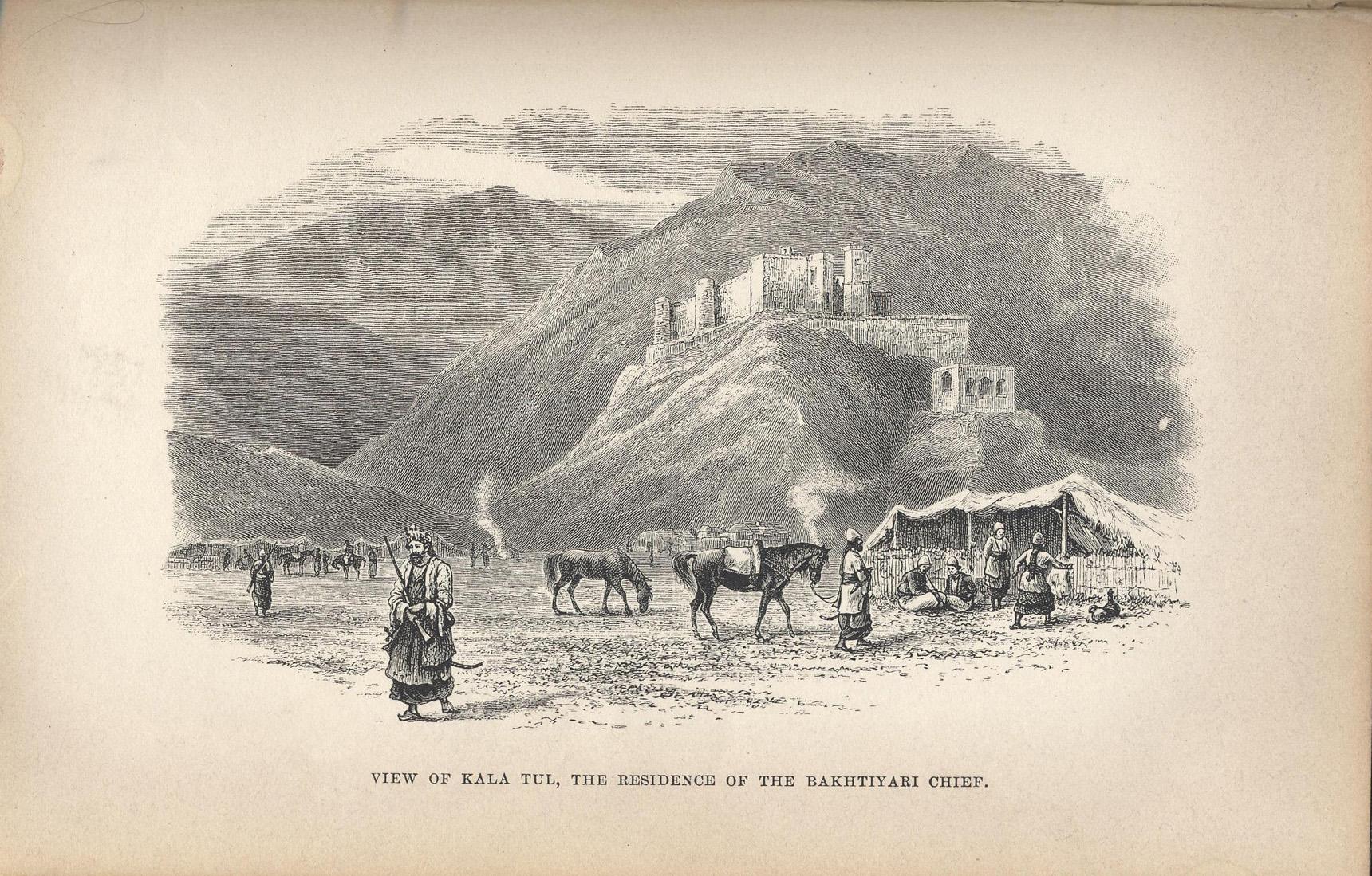
- Continuing SE to a T-Junction, then left and @ 40 twisty km.s east to the T-junction with the 72, and north @ 10 clicks is Qalehtol or 'Kala Tul', home to the remains of 'Khamisi castle', an impressive, rectangular, relatively intact brick and fieldstone fortress on a hill in the centre of town, next to a ruined, well-excavated adobe complex. It would be famous anywhere o/s the Middle East. Constructed by Mohammad Taqi Khan Bakhtiari, it was visited by Layard and mentioned in his travelogue. www.google.com/maps/place/%D9%82%D9%84%D8%B9%D9%87+%D8%AA... Here's a print of this "mountain castle where Layard ... stayed when he visited, and fought with, the Bakhtiari".: carolinemawer.com/wp-content/uploads/2018/09/early-advent...
- www.rogersandall.com/young-layard-of-nineveh/
- This is a very scenic area, popular with local hikers with arid river-bottom canyons, Alpine scenery, clear streams, wildflowers and colourfully dressed, native, nomadic or semi-nomadic Bakhtiari women. The river widens into lakes and reservoirs upriver of the Karun dam (205 m.s tall) and resembles the Tortum lake in NE Turkey at points.
- Less than 1 km. SW of Oshtor Gard, a village @ 10 clicks NW of the 72 where it turns sharply east, is a rustic, white-washed shrine with a wider, squatter answer to the sugar-loaf dome at Daniel's shrine in Susa.
- Finally, the 72 climbs north to Izeh, a city of just > 100,000 populated by Bakhtiaris and renowned for its fascinating Elamite and Parthian-era monuments. It's worth a day or 2 or 3.
1. Kul-e Farah: an open-air sanctuary in a gorge with 6 Elamite rock reliefs, likely Neo-Elamite, depicting processions, animal sacrifice, musical performances, and banqueting (one communal banquet is depicted with 141 participants, min.), with cuneiform inscriptions. The depiction of groups of participants "offer[s] a spectacle of social hierarchy determined by scale, placement within registers, physical relationship to rulers, garment, gesture, and activities". See photos from the 2:40 min. pt. to 4:45.: youtu.be/N2xEG4I5lJ8?si=g7-pBCs5jAYQQJmU
2. Eshkaft-e Salman: 'Salomon's cave', the 'romantic grotto' in a valley just west of town, with 4 reliefs of 9 members of the Elamite royalty dating from @ the 12th and 11th-7th cent.s BC. wearing interesting outfits, 'visor' hair-dos, braided side-locks, back-braids, etc.;
3. Tagh-e Tavileh: ruins of bldg.s in stone and plaster with tilework from a settlement built by Kurdish Hazaraspids in the Ilkhanate-Timurid period, at the NW edge of town;
4. Dasht-e Sūsan or Shir-e Sangi (the 'Stone Lion cemetery'): a cemetery with a collection of 18th-20th cent. stone, stylized sculptures of lions carved in the round as tomb monuments for Bakhtiari tribal leaders, war heroes, et al., @ 10 km.s due east of Izeh, south of the 72;
5. The Shah Savar relief: a 17th cent. BC (!) relief on a cliff-face @ 10 km.s from town, with a seated figure facing a line of 5 supplicants in a single register;
6. Khong-e Kamalvand: a Parthian-era relief with a standing figure next to an equestrian, with an Elymaean inscription, “Phrates the priest, son of Kabnuskir”, 10-15 km.s north of town;
7. Khong-e Ajdar: an ancient Elamite relief on one side of a large boulder and the largest relief from the Parthian era on the other depicting the Baara'aam, a ceremony in which the local independent Elymais ruler and 3 standing local dignitaries meet with or confer power on a seated, visiting Mithridates of Parthia with the release of 2 doves, @ 15 km.s north of town; and
8. Khong-e Yaralivand: a relief with 2 standing men in tunics and trousers in an investiture scene, @ 12 km.s north of Izeh.
- The photogenic imamzadeh of Sultan Ibrahim in Karta village (Maveh on google maps) @ 40 clicks north of Izeh. (Unfortunately it appears to have been almost completely renovated recently.) tishineh.com/touritem/211/Tomb-of-Sultan-Ibrahim
- The Zardeh Limeh waterfall, @ 30 clicks as the crow flies NE of the 72 from a point @ 15 clicks east of Izeh, is one of the most impressive in Iran per Google maps.
- From ancient Izeh, the road turns and proceeds SE and passes within 2 clicks of the 205 m. tall Karun-3 dam, descends through a tunnel and crosses the Shalu Arcus bridge. Wow. youtube.com/shorts/HVTR7TKzo9w?si=bRUgkNplxnvTkBdj (Huge dams can be deadly in an earthquake zone, but at least this isn't upstream from a neighbouring country like Egypt is from Ethiopia, Iraq and Syria from Turkey, etc.) The 72 then leaves Khuzestan and crosses the provincial border into 'Chaharmahal and Bakhtiari' province as it passes below and then up next to the Karun-4 dam, the tallest in Iran, @ 15-20 km.s further east youtube.com/shorts/36b185d9jak?si=pcqQXkRrn6M0ZM1w before it navigates a series of tunnels and crosses another impressive single-span bridge, and twists north through two sharp hair-pins, all in a wonderfully scenic area. An incredible drive! (How much of that route would've been in place in 2000? Did the road follow alongside the much more narrow river then before the dams arrived or would I take the 55?)
- The 72 continues up along one of the twistiest roads I've ever seen on google maps soon passing villages of Lurs. Turning left onto the 51 where it meets the 72 and turning left again at a fork at Teshneez, the 200 yr. old fortress of Sardar Gholam Hossein Khan Salar Mohtsham, an adobe ruin, sits in the centre of Dastena, a town @ 2km.s south of Amirabad on that road, and which brings one to Junaqan, 35-40 km.s from the 72, home to the 'Palace museum of Sardar Asad Bakhtiari', "one of Iran's constitutionalist generals", in a lovely Qajar-era bldg. with a veranda on the 2nd floor, which focuses on the Constitutional movement and the Bakhtiari uprising in that city which (it's claimed) began in this palace and led to the Bakhtiari capture of Esfahan and Tehran.
- The bus might have driven up the 51 in 2000 en route to Esfahan or (more likely I think) it continued on the 72 to Borujen and up via Majlesi to Esfahan. North of Sirak Hafshejan on the Taqanak rd. SW of Taqanak on the 51 is an Armenian cemetery with interesting 19th cent. tombstones. The city of Hafshejan 3 km.s east of Taqanak is said to have existed as a community for @ 9,000 yr.s.
- The 'Sacred Defense museum' in the north of the city of Sharekord (on the 51 @ 5 clicks east of that [less likely] route to Esfahan) focuses on the Iran-Iraq war, etc. and has some avant-garde architectural aspects.
- The 'Chaleshtor castle' along the Blvd. Rahbar @ 5 km.s NW of that city is a lovely late-Qajar-era mansion and museum with a large courtyard, the former home of the Bakhtiari chieftain Khoda Rahm Khan.
- The historic Zaman Khan bridge persists with its 2 arches @ 20 clicks NE of Shahrekord, a few north of Saman.
- Bagh-e Bahadoran en route East to Zarrinshahr and towards Esfahan on the 51 is home to another adobe and brick castle with corner towers.
- Etc. ... Zarrinshahr is within day-trip distance of Esfahan, 30-40 km.s further, so that list will do.
BUT, again, I was clueless and bussed it back to Khorramabad, missing Izeh and this more direct, much more interesting route to Esfahan entirely. From Khorramabad, my bus headed due east on the 37 for @ 40 - 50 clicks, and then turned round and headed SE down the 62, the Dorud Chalanchulan Expy. (good and fast) and passed Dare Tang just past the turn. (Stop in Dare Tang and have an adventure or misadventure and later say "So I was in Dare Tang and ..." "What? Where?" "Dare Tang! So I was walking along and ...")
- Awesome hiking's to be had to snow-clad peaks and ice-caves @ Oshtoran Kuh, 10-15 clicks south of the 62 as the crow flies from 'Tian Village' and @ 40 km.s east of Dare Tang.
- The grand, visibly ancient Imamzadeh Qassim and Zeid dates from the early 13th cent. with renovations in the 14th and 15th cent.s, @ 30 clicks north of the 62 and Azna (@ 20 km.s east of Tian) up the Azna-Arak rd, and 2 east of it.
- The 62 passes through the city of Aligudarz @ 20 km.s further east, home to Sayleh castle and the Masisilan ancient hill (per Wikipedia), and surrounded by more awesome scenery.
- Just west of the 62 a few km.s SE of Bueen Miyandasht is the village of Dashkasan which has a population of ethnic Georgians (!) who speak a Georgian dialect together with Persian. Khoyegan Oleija, a Christian community (evidently) a few km.s further south has 4 old churches (!) incl. one that's Armenian and an impressive 'Old [Armenian or Georgian] cemetery.' 60% of the population of the town of Sadeqie further SE, @ 8 km.s south of the 62 and Ozun Bolagh, speak Georgian ([Wikipedia] Not Armenian? How and when did Georgians move to Central Iran?) and @ 30% speak Azeri. The village of Seftjan, @ 3 km.s south of the 62 and @ 7 SE of Nahrkhalaj has 2 churches incl. one that's Armenian and another ancient Armenian (or Georgian?) cemetery. A small, visibly ancient (Armenian?) church just east of Khuygan-e Sofla, a town of Luri-speakers with an Azeri minority, is @ 10-15 km.s further south.
- Vaneshan village looks to be fascinating and fun @ 30 clicks NE of Noqan and the 62 and < 10 clicks south of the 47, much of which is visibly ancient, with some intact and restored ancient adobe walls and a gate all in brick and adobe, and with some adobe ruins, all beneath mtn. peaks. (Somehow nothing's written about its charms in its Wikipedia entry.)
- Khansar is another visibly ancient brick and adobe village, much of it double-storied, further south and equidistant /b/ the 47 and the 62. It's home to the ancient brick Abhari mansion with its many stucco reliefs. The impressive ancient adobe-brick Chahar borj pigeon tower stands further north just south of Qudejan and an ancient brick mosque.
- Less than 10 km.s NW of Vaneshan, on the 47 @ 30-35 clicks NE of Noqan and the 62, is the city of Golpayegan, home to an impressive, visibly ancient Seljuk Jāme' mosque (1114) youtu.be/q-Kc8MDD2uk?si=DhsC_5NOYt5dgu-K , a tall, ancient Seljuk brick minaret, the 15th-16th cent. Sarāvar mosque, and the 17th cent. Hevdah Tan shrine. "Golpayegan Kebab is unique and made from endemic cows, and is registered as Iranian 'intangible heritage'." (Wikipedia) Locals speak Persian and the Golpayegani dialect. 5 km.s further north, the early 17th cent. Gouged fortess/caravanserai, one of the largest adobe structures in the country, is now a hotel.
- The 47 runs along what must have been a medieval trade route in light of the ruins of several caravanserais along it, incl. brick ruins on the outskirts of Tikan on the 47, 30-40 km.s NE of Daran on the 62; impressive ruins in the village of Dor @ 8-10 km.s further SE down the 47; and the relatively intact Jelowgir caravanserai by the 47 @ 25 clicks NE of Damaneh and the 62.
- An extensive, ruined adobe village complex can be explored at Rahmat Abad @ 15 clicks NE of Do Shakhkharat and the 62, @ 10 SW of the 47.
- The town of Damaneh is home to some subterranean hand-carved tunnels.
- Domab, @ 10 clicks SW of the 47 and @ 35 NE of the 62 (from a pt. on that rd. @ 15 km.s SE of Damaneh) is home to an impressive adobe fortress, a small museum, and the town has a website: web.archive.org/web/20060325100147/http://domab.ir/Englis... and an unusually fulsome Wikipedia entry. (Very many villages in Iran have Wikipedia pages, the vast majority of which only offer population stats.) The entry ends with this.: "There is a historical story about Domabian people that tells there were all with tails after the fight with Mongoliasm [sic]; However it is not true." This should help to discourage the many local tourists who visit Domab to see the locals and their tails (I assume).
- 2 clusters of ancient petroglyphs on schist rocks near Domab depict hunting scenes and plenty of ibexes.
- A network of tunnels or sculpted caves winds beneath Kurd-e-Olyã or near that town less than a km. south of the 62, @ 30 clicks SE of Damaneh.
- A rare historic suspension bridge made with logs tied together, 'Gappaz Garmdareh' on google maps, seen here on Instagram www.instagram.com/chadegan_javanan/reel/CsUBxa1gBxF/, and here on Youtube: youtu.be/g1RG3T6dv-c?si=gKofwADTRe9zgIhW , remains photogenically suspended above the Zayandeh rud @ 25 clicks S-SW of the T-junction of the Chadegan rd. with the 62 and @ 10 km.s East of Yancheshmeh.
- The time capsule that is the town of Yaseh Chah, @ 25 km.s SW of the 62 as the crow flies, a couple south of Markadeh, is explored in this vlog.: youtu.be/uZAj3vEO46Q?si=1xdjoQeM5w5vta-W It's popular for its "old corridors and special architecture".
- The restored high stone and adobe walls of an ancient castle dominate the town of Jaja alongside the 62 @ 60 clicks SE of Daran. commons.wikimedia.org/wiki/File:Historic_castle_of_Jaja_v... My bus passed only @ 250 m.s from it and I'm sure it impressed me if I wasn't reading something just then.
- On the southern outskirts of Tiran 2-3 km.s south of the 62 and 5 km.s SE of Jaja is a path beside an ancient plastered brick wall with at least 2 swinging stone doors similar to this one in Jordan.: www.flickr.com/photos/97924400@N00/7137438437/in/photolis...
- In the desert at Ghameshlu, @ 30 km.s NE of the 62 and Tiran, is an impressive ruin of a vast, Qajar-era hunting palace built for Zal al-Sultan near the "aqueduct of paradise" (according to a comment on google maps) with old black and white reproductions of photos and prints from magazines or newspapers and European maps covering the walls and ceiling in at least one room. youtu.be/Al_jSI4XDT4?si=vyFGNP-xT9_I5QRP
- Najafabad, a city developed by the Safavid Shah Abbas, is home to the well-maintained Sheikhbahaei Fort with a tall tower similar to a pigeon tower. The lovely, large 'Noorian historic house' is now home to a bookstore or library, a photo gallery, and a cafe.
- Jowzdan, 5 km.s south of Najafabad, was founded @ 800 yr.s ago in the Timurid period by the denizens of Gorg Abad, "a small town near Kooh Panji in the Zagros, [who] faced a huge threat from wolves in that area [!] and started refuging to start a new town." (Wikipedia)
- Jahadabad, @ 20 km.s north of Najafabad, is home to the impressive, relatively well-preserved Sheikh Ali Khan chaleh siah caravanserai.
- Anything closer to Esfahan on or close to that route down the 62 could be in 'greater Esfahan'.
- So although I might've seen a fortress or castle through the bus window, there was much I missed en route to Esfahan.
- On my arrival in Esfahan I headed to a popular youth hostel to rent a bed and then spent much of the next 9 days touring some of the loveliest buildings on earth. "Esfahan is half the world!" is the old adage.
- Continued in the write-up for the next photo of the ceiling of the dome in the Masjed-e Emam.
Oct 00 - Under one of the oldest arches in Iran, in a royal Elamite tomb, Chogha Zanbil (13th cent. B.C.), Khuzestan prov.
- "The 'royal quarter' was a little > 200 m.s NE of the outer enclosure wall [of Chogha Zanbil's temple complex], accessible through a massive gate structure in the eastern city wall. It consisted of 3 large bldg.s or 'palaces' (and likely a 4th no longer extant) with multiple courtyards. Palaces II and III were poorly preserved, although they were planned and executed on a monumental scale and date from the time of Untaš Napiriša. Palace I, the hypogeum palace, with its 5 vaulted subterranean burial chambers, remained in use until @ 1000 B.C., possibly as a place of pilgrimage. Unlike Susa or Kabnak (Haft Tepe), where tombs were used for multiple burials, the subterranean vaults at Āl Untaš Napiriša contained only one skeleton each; the rest of the bodies had been cremated. Why cremation has been attested only in the tombs of Āl Untaš Napiriša is unknown." (Iranica online)
- Scroll down in this technical article to the 6th to 8th pages (pp.s 371-373) to see cross-sections of the 5 royal Elamite tombs here. www.scielo.cl/pdf/rconst/v19n3/0718-915X-rconst-19-03-366...
- I toured at least a few Elamite royal tombs here, all with a similar layout. The others were less hospitable than this, with floors covered in black bat guano. In one the stench of ammonia was close to overwhelming and I heard very much high-pitched screeching. A narrow passageway vertical to the main chamber led from an entrance in one wall to what appeared to be a parallel chamber, but which I've just learned (from viewing the diagrams in the analysis in the link above) was an equally long or longer chamber positioned vertically which widened from the entrance passageway, itself just @ a few m.s long. That long, vertical, unlit chamber was a bat cave, almost entirely dark but a space alive with motion and a mass of small shapes zipping back and forth from the floor to the ceiling in a frenzy or panic as I walked slowly closer to the threshold of their lair. As large as I've just learned the chamber is, it was full of them. (I now think that that chamber was the tomb proper, and that I was standing in an antechamber.) I'll never forget the piercing screeching, the power of the stench, and the space alive with zipping shapes. I was curious but didn't dare go further in.
- The 2012 LP edition for Iran (the most recent at archive.org) and 2008 and 2004 write that "steep ancient steps lead down into Tomb no. 5. Descending is unwise as the pit stinks of toiletry misdemeanours, especially bad when the temperature hits 45 degrees celsius." Either none of their contributors went down to take a look and no-one's written to disabuse them of their 'misdemeanours' theory, or its editors have discouraged exploration of these tombs to protect and give some peace to the local bats, the right thing to do, of course. It's trite to say that the bats are very important. youtu.be/HDL04dPtcyE?si=-CsAdbdQzu1bAtjS I wish I'd returned in the evening to watch them emerge from the tomb in a great cloud. (Btw, the greatest variety of bats anywhere on earth, and by far and away, is in South America.)
- This comes up in a search online for Bats in Iran en.wikipedia.org/wiki/List_of_mammals_of_Iran , but nothing re species in Khuzestan/Khuzistan.
The DEZFUL BRIDGE and the ruins of WATER MILLS on the Dez
- I made my way SE from Andimeshk one evening to the city of Dezful (Dehz-fool) on the river Dez (by bus or minibus or taxi? The cities are @ 5 or 6 km.s apart.) I don't remember what I'd been told about Dezful, but likely that it's a much older city than Andimeshk. So I was impressed when I arrived at the bank of a river at a spot beside and before another visibly ancient bridge stretching across it with huge piers and arches made of fired mud brick (and with a few new ones near the NW end). Again, I find that reading up re the sites and sights I toured so long ago is really worth doing. This bridge is a case in point as I've learned that it was Sassanian (with foundations dating to the Elamite era), that it's quite famous, constructed or reconstructed in 260 AD by Roman slaves, and that it's one of the oldest bridges in active use anywhere, still featuring 14 original arches. In fact, it's the world's longest ancient bridge in current use, 5 or 6 or so times longer than the competition, spanning 385.5 m.s, 9.5 m.s wide and 15 m.s in height. Only the Pont du Gard aqueduct (40-60 AD) near Nîmes compares at 275 m.s in length, 6.4 m.s wide, and a much taller 48.8 m.s in height.
- Shapur I was famously responsible for its construction or reconstruction and that of the weir over the Dez. Construction was supervised by Roman engineers, whose "employment ... was due not to the lack of skilled Persian engineers, but to the fact that these Romans happened to be available there at that particular time" (according to L. Lockhart, 'Persian Cities'). A Roman field army of 50-60,000 was destroyed and Roman troops and Emperor Valerian (he of the infamous 'Decius Decree' of 257) were taken captive by Shapur I and his Sassanian force of @ 40,000 at 'The Battle of Edessa' (a site /b/ Carrhae and Edessa [latter day Urfa]). Valerian was the first Roman Emperor in history to be captured as a POW "causing shock and instability throughout the Roman empire". According to Lactantius (a Christian writer who was likely biased against Valerian) Shapur liked to use Valerian as a human foot-stool when mounting his horse. youtu.be/yx1NzpLF1N8?si=LtTIF9TLDFvR9XXE youtu.be/gAKrPSlmjm0?si=TrInQefUq1A6uCcc Roman soldiers were skilled craftsmen, and so Shapur put them to work as POWs. "A characteristically Roman feature of the bridge is the inclusion of supplementary openings over each pier which serve to ease pressure on the structure when the river is greatly in flood." (L. Lockhart) It was repaired several times by Safavids, Qajars and early Pahlavis.
youtube.com/shorts/97I7gNzEp3g?si=7FaLcYHJ6iSB9z1R
youtu.be/yewJY30o1-w?si=6gnE33lJImvu0Pgx
- I sat by the river below the bridge and had a picnic with food I bought somewhere. To one side the ruins of ancient water-mills stretch out into the river, built on rocks which produce rapids. In 1840 Baron de Bode wrote that "[t]hese little islets are united by narrow bridges, and at the approach of night, when the millers trim their lamps, there is a perfect illumination on the river." The islets and little bridges are seen at the 1:36 min. pt. in the last video above, and at the 5:25 min. pt. in this vlog.: youtu.be/xJankVjF3xI?si=e5RiWVixCj6JuQpN (I didn't explore them like the vlogger does, but I saw them from the bridge, the view at the 9:05 min. pt., as well as from the shore. I didn't know what they were.)
- I don't recall how much more of Dezful I saw than the bridge and the ruined mills in the river, but I must've strolled around some. Baron de Bode described the bldg.s of Dezful as "lofty and spacious, most [with] sardabs or chambers hewn out of the rock beneath them into which the inmates retire during the heat of the day in summer." See sardabs or 'shavadans' in the great vlog in the last link from the 15:10 min. pt. to 16:00 and a popular, deep qanat (popular for its A/C) from 26:00 to 27:35. The vlogger explores the old part of town with its bldg.s made of characteristic long, flat, yellow bricks from the 12:25 min. pt. to 20:50. 113 brick monuments in the city have been registered on Iran’s National Heritage List, incl. mosques, hamams, houses and 'archways'. (He tours a couple of sprawling house museums, at least one of which wasn't open to the public in 2000.)
- Another miss in his video is the narrow Emamzadeh of Seyyed Ali Safavi aka Pire Rudband (Timurid, restored under the Safavids), a Shi'ite missionary and the grandson of Sheykh Safi addin Ardabili, with its typical sugarloaf dome, and wonderfully situated high atop a cliff above the Dez (21:50 to 22:25).
History of Dezful
- Founded in Sassanian times (although, again, the base of the famous bridge was Elamite), the city was known as Andimishk in its earlier history; the name Dezful, a variant of Dez-pul, 'fortress-bridge', didn't come into use until the 14th cent. An infamous fortress was erected to protect the bridge from which the current name of the city derives. It "was used not only for purposes of defense, but as a veritable 'castle of oblivion' in which persons of high degree were imprisoned, as at the castle of Alamut in Safavid times. No one was permitted under pain of death to speak of this fortress, nor of anyone who had the misfortune to be incarcerated in it. Curiously enough, the exact position of this sinister castle remained a mystery for centuries until it was discovered, from an Armenian source, that it was at Andimishn, which was of course Andimishk. The Armenian king, Arshak III, was immured in this castle having been taken prisoner in battle. Despairing of ever regaining his liberty, he stabbed himself to death in 367 AD. Another illustrious prisoner, the Sassanian monarch Kavadh (aka Qubad) I, who ascended the throne in 488, was deposed some years later for his espousal of the heretical doctrines of Mazdak and his distaste for Zoroastrianism. Having languished for some time in the dungeon, he was rescued by his faithful adherent Siyavush. But according to Procopius and other writers, it was Kavadh's exceedingly beautiful wife who effected his deliverance. She promised to bestow her favours on the governor of the fortress if he would first allow her to spend an hour with her husband. Upon gaining admittance to his dungeon, she immediately changed clothes with him, and when the allotted time for the meeting had elapsed, he succeeded in making his way past the guards and out of the fortress [what about her deal with the governor?], while his wife remained behind. ... Kavadh subsequently regained his throne and reigned until his death in 531." (L. Lockhart) I haven't found any reference to this baleful donjon online (apart from a brief reference in the vlog. in the link above from the 10:23 min. pt. to 10:40.) I guess it's entirely gone?
- "It must be admitted that the history of Dezful for the greater part of the Islamic period has been relatively uneventful. ... When Timur appeared before the town in March, 1393, having subdued the Lors, it promptly submitted to him and thereby escaped his wrath. It was probably soon after his visit that Khwaja 'Ali, the grandson of Shaikh Safi of Ardabil (the occupant of the Emamzadeh mentioned above), came to Dezful and converted the inhabitants to Shi'ism by miraculously holding up the waters of the Ab-i-Dez" according to legend.
- Sometime @ 1830 "an Armenian introduced a new method of preparing indigo which was practiced with great success in Dezful. Many of the inhabitants were employed in this industry, and the dye was in great demand in all parts of Persia. Late in the 19th cent. however, imported dyes made the local industry uneconomic."
- Mandaeans: Baron de Bode visited Dezful in 1840 and met with members of the local Sabaean or Sabian aka Mandaean community. "[F]rom one he obtained part of a copy of the Ta'rikh-i-Yahya or 'History of St. John'." Many Mandaeans/Sabaeans, pre-Christian baptists in an ancient sect who venerate John the Baptist and claim him as the founder of their faith, have moved to Ontario in the last 20 years. I heard or read somewhere that they have a temple or an administrative base in Maple. I bet they brought some ancient texts here with them.
- Located in SW Iran, the city is known as the “City of Rockets”, as it fell under rocket attacks > 200 X throughout the Iran-Iraq War.
Other misses in town:
- The early Qajar Kornasiyon hamam is now an anthropology museum.
- The 15th cent. emamzadeh of Shah Rukn ad-Din (a contemporary of Tamerlane) under a blue, 14-sided, conical dome. A Timurid hamam is on-site.
There was plenty that I missed in the area.:
- The famous Emamzadeh of Yaqub Layth Saffari aka Saffarid Yaʿqub b. Layṯ (840-879) beneath its brick, sugar-loaf double-dome (similar to that at the tomb of Daniel in Shush but not white) is at Eslamabad, @ 2 clicks SW of the 39 (the road to Shushtar), @ 12 SE of Dezful and less than 2 north of the ruins of the fabled Sassanian city of Gondeshapur (see below). The occupant is revered in Iran. A coppersmith born in 840 in Karnin, east of Zaranj in what is today Afghanistan, Yaqub fought as a child soldier against the Tahirids, was later promoted to commander, declared himself emir, conquered non-Muslim lands to the east in what is today Afghanistan and Pakistan, and then liberated most Iranian states from the Arabs, incl. much of Afghanistan, Pakistan and Iran by 873, reuniting them following 200 yr.s of Arab rule. He then sought to take Baghdad and the Caliphate but was defeated by the larger forces of Caliph al-Mu'tamid. He had defeated the Khawarij, Alawites and Tahirians, founded the Saffarid dynasty, and ordained the resumption of the use of Persian as the official language of his empire, cementing his folk-hero status. The story goes that when a bard composed and sang an ode to him in Arabic per the custom of the time, he criticized him for reciting it in a language he didn't understand. Henceforth, court poetry was written in Persian. (I'm reminded that the English endured a francophone administration, nobility and civil service for @ 200 yr.s, from the arrival of the Normans in 1066, until they finally said "Enough".)
www.google.com/maps/place//@32.3009043,48.5184038,2767m/d... The emamzadeh is said to be surrounded by garlic farms. It was a miss. Here's a tour of the tomb from the 1:45 to the 5 min. pt.: youtu.be/xJankVjF3xI?si=OkVzsBdHAFheHo0q
- The site of the legendary Sassanian city of GONDISHAPUR or Gondēšāpur (identified with extensive ruins south of Shahabad, a village 14 km.s SE of Dezful):
Gondēšāpūr or Gundēšāpūr derives from 'Wandēw Šāpūr', "Acquired by Shapur", or 'Gund-dēz-i Shāpūr', "Military fortress of Shapur", or the Mid. Pers. 'Weh-Andiyōk-Shāpūr', 'Better-than-Antioch of Shapur' or 'Better Is Šhapur's Antioch' (Wikipedia). In his vast travels, Shapur I (r 242-272), the 2nd ruler of the Sassanian Persian empire, famously defeated the Roman Emperor Valerian III (r 253-260) and sacked city after city incl., infamously, Antioch-on-the-Orontes twice, in @ 256 and again in 260, where he said "This place sure is purty", rounded up its craftsmen, architects and artisans and marched them back to Khuzestan to build and beautify a new city to be defined by Shapur's plans to surpass Antioch, the third largest and third most glorious city in the Roman empire. Shapur's official record of the satrapy of Weh-Andiyōk-Shāpūr is in his famous trilingual inscription at Kaʿba-ye Zardošt (which I toured) at Nagsh-e Rostam near Persepolis, and archaeologists have found "no trace of habitation prior to the early Sassanian period." The city became a Sassanian royal winter residence and the capital of Khuzestan prov. "Architectural remains [of] an orthogonal street grid within an oblong, rectangular walled enclosure [have been excavated], thus approximating Ḥamza Eṣfahāni’s idealized description of the site’s layout as a chessboard of eight by eight streets." (Iranica encyclopedia) The city was also home to the East-Syrian metropolitan see of Bet Huzaye and a centre of Christianity, at least until the accession of Shapur II who persecuted Christians. The Catholicos Šāhdōst and others were tried there in his presence and executed in the 340s. But Gondēšāpūr was again predominantly Christian in the 5th and 6th cent.s and up until the Arab-Muslim conquest of 638. (Iranica online)
- A great and flourishing city, Gondēšāpur was "the intellectual centre of the Sassanid Empire and home to the Academy of Gundeshapur, [a 'centre of higher learning' if not a university] founded by Shapur I, and to a teaching hospital and famous library. ... [T]here are reports of systematic activities [science?] initiated by the Sassanian court as early as the first decades of Sassanian rule. [Research results] were collected and added to the Avesta during Shapur's reign. The foundation of the Academy led to a combination of Greek and Indian sciences with Iranian and Syriac traditions and introduced the study of philosophy, medicine, physics, poetry, rhetoric, and astronomy to the Sassanian court. According to some historical accounts, the Academy was founded as a home for Greek refugees to study and share their knowledge." But the references to Greek refugees that I've found date from the reign of Justinian in the early 6th cent. (See below.) It's claimed that the cosmopolitan nature of the institution became a catalyst for the development of modern systems of higher education. George Sarton, the famous historian of science, described Gondēšāpur as "the greatest intellectual centre of its time". ! (The latter 1/2 of the city's history was coincident with the 'Dark ages' in Europe.)
- The site of the ruined city is filmed from the 11 to the 12 min. pt.; 28:30 to 28:45; 45:30 to 46:15; and I think from at least 53:40 to 54:08 in this.: youtu.be/fFMwR9phzC8?si=JlduyBfHmVK7u7x8 (English subtitles please?)
- "In 489, the East Syriac theological and scientific 'School of Edessa' [latter-day Urfa] was ordered closed by the Byzantine emperor Zeno, and many of its teachers and scholars moved east to and were absorbed into the 'School of Nisibis' [Nusaybin in SE Turkey today, on the Syrian border], then under Persian rule. Nestorian scholars, together with Hellenistic philosophers banished from Athens by Justinian in 529, carried out important research in medicine, astronomy, and mathematics. Khosrow or Khosrau I (531-579) gave refuge to Greek philosophers and Nestorian Christians fleeing religious persecution in the Byzantine empire. The Sassanians had long battled Romans and Byzantines for control of latter-day Iraq and Syria and so were predisposed to welcome the refugees, who Khosrau then commissioned to translate Greek and Syriac texts into Pahlavi, incl. works on medicine, astronomy, philosophy, and useful crafts. Gondēšāpur soon became renowned for medicine and learning."
- From Iranica online: "Gondēšāpur’s real fame rests on its alleged role in the transmission of ... Galenic medicine and the institution of the teaching hospital (bimārestān) to urban Abbasid society and beyond to Islamic civilization at large. The earliest testimony to Gondēšāpur in the context of the field of medicine is to a medical-philosophical disputation convened in @ 610 on the orders of Ḵhosrau II in which the drustbed (q.v.) Gabriel of Šiggār participated. The hospital itself first finds specific mention in the year 765 when caliph al-Manṣur is said to have summoned the then head of the hospital, Jewarjis b. Jebrāʾil b. Boḵtišu', to Baghdad. ... Syro-Persian Nestorians were weaned at Gondēšāpur on what later biobibliographical authors celebrated as superior medical learning, [derived] in the Sassanian period from outstanding individual Greek and Indian as well as local Aramaic and Iranian sources." Physicians from such Nestorian families as the Boḵtišus (the directors of the hospital) and others had brilliant careers "in the orbit of the Abbasid court" in Baghdad. They also "rediscover[ed] Galen and other classics of Hellenistic medicine and pass[ed] them on to the Muslims." (Iranica online)
- Mani (216-277), the founder of the Manichaean religion, experienced his "doomed confrontation with King Warahrān I and his counsellors" in Gondēšāpur per Manichaean tradition, and was imprisoned and died there in 276 or 277 per nearly unanimous Sassanian and Arabic sources. It's said that his body was hanged from the gates of the city. I find Mani and Manichaeism fascinating. Mani was born into a Christian Elcesaite community near Seleucia-Ctesiphon in the Parthian period. He claimed to be an apostle of Christ but espoused a syncretic religion drawing from Zoroastrianism and Buddhism as well, best known for its focus on dualism and the conflict /b/ good and evil. 'Manichaean' is used as an adjective today to describe a position or perspective as simplistic, 'black and white' or 'good v. bad'. The religion became very widespread with adherents from Britain in the West to the East China Sea. In fact some scholars consider it to be the first 'world religion'. But Manichaeans were generally persecuted as heretics and the religion dissolved in the 15th cent. (I toured the Chester Beatty Library and museum in Dublin in 2010 [which has the best book-store I've ever seen at a museum] with its choice collection of ancient religious manuscripts, where I perused the famous 'Mani Codex', a unique, important 4th or 5th cent. Manichaean papyrus manuscript found in Egypt.: youtu.be/BYJtscOudUg?si=6unHgdTVrt2BcJTn )
- The town fell into decline following its surrender to the Arab-Islamic conquest of Persia in 638, although it remained an important centre in the Islamic period. Ya'qub ibn al-Layth al-Saffar, the legendary founder of the Saffarid dynasty (see above) who "aspir[ed] to imitate the Sassanians", made Gondēšāpur his residence and his capital in 875 or 876 @ 3 yr.s before his sudden death in 879, and his tomb became the most prominent feature of the city. But by the 10th cent., "the city had suffered so severely from the inroads of the Kurds that it fell into decay."
- So, as cerebral as it is, a tour of the site was a big miss.
- The entertaining, charismatic Dr. Roy Casagranda, who now has shorts from his lectures all over youtube, makes shit up in this video re 'the Gondishapur academy'. youtube.com/shorts/DbxU3b4IA3w?si=0Dl0sX4hVbL85c2t He claims that Shapur built his academy as "the Persian equivalent to the Great library" of Alexandria, and collected Chinese and Indian texts incl. Lao Tzu's Tao te Ching, which was "amazing ... because when Qin the Great [Qin Shi Huangti] unifies India [China], he bans [the books of] Lao Tzu [but in the late 3rd cent. BC, > 400 yr.s earlier; Taoism and Confucianism had been revived in China by the early 1st cent. BC] and starts wiping out Lao Tzu's works, but now there's a place for them to survive." Nope.
- The scenic Mohammad Ali Khan (aka Ali Mardan Khan) fortress @ 40-50 km.s NE of Dezful is a natural citadel on a high mesa, 1,550 m.s in height, surrounded by sheer cliffs and by the Haft-Tanan mtns., the site of a refuge and an eyrie in ancient times.
- I can't account for my thought process (if I can call it that) when I left Khuzestan by bus for Esfahan via Khorramabad and the 5 and the 62, but of course I should've sought out the wealth of ancient Elamite sites further east @ Izeh en route to Esfahan via the twisty, more adventurous 72. There was a dearth of anglophones in Andimeshk, the map in my thin LP guide was hand-drawn, and I didn't come across a library or tourism office where I could get a clue (again, I found Dezful's huge, ancient bridge by chance), not that that's any excuse. It's a shame I missed the following along that route.:
- At least 3 ancient brick piers, the remains of an ancient bridge, stand @ 10 clicks NE of the 39 above where the road turns north to Sar Bisheh.
- SHUSHTAR, an ancient Elamite, Achaemenid, Parthian and Sassanian city (possibly the 'Sostra' mentioned by Pliny the Elder) @ 60 km.s down the 39 SE of Dezful, is home to an ancient Sassanian hydraulic system designated Unesco world heritage in 2009, comprised of 13 sites incl. the famous bridge/dam or weir (see below), and an array of waterfalls which once powered water mills and which pour into the Gargar canal from above both of its banks, the most famous and photogenic tourist attraction on that long route. youtu.be/Cc6gG48wvdE?si=SrfRKN7l2U3Md3eW The irrigation system which centered on the Band-e Kaisar aka the Shâdorvân Grand Weir, the first dam bridge in Iran, was "considered 'a Wonder of the World' not only by the Persians but also by the Arab-Muslims at the peak of their civilization" (Unesco). (Again, Iranians don't take water for granted.) A ruin today, the said bridge and overflow dam spanned > 540 m.s as a link on the road from Pasargadae to Ctesiphon, and is believed by some to have been built by Roman POWs captured by Shapur I. "Local tradition attributes certain customs to the ancient Roman [prisoners] ... [incl.] the introduction of techniques of brocade manufacture." ?
- The development of this hydraulic system began during the 5th cent. BC reign of Darius the Great with the excavation of two main diversion canals on the Karun, one of which continues to provide water to the city via a series of tunnels that powers the mills and irrigates an expanse of orchards and fields @ 40,000 ha.s in area known as 'Mianâb' ('Paradise'). It supports the cultivation of sugar cane, the main crop, and has done since 226. What remains to be seen of the ancient system today dates from @ the 3rd cent. The Unesco site includes the Salâsel Castle, the operations centre, the tower where the water level was measured, similar to an Egyptian 'Nilometer', and from which dams, bridges, basins and mills were managed and maintained. (Unesco)
- The city was selected to become the summer capital of the Sassanian empire when it was an island city and the river was channeled to form a moat @ it. It was known for its output of textiles throughout the Middle Ages, producing brocade, tiraz, carpets, cotton fabrics and silk. In fact, the city was "chosen to produce the Kiswah (the embroidered covering for the Kaaba) in 933 - a great honour with political importance."
- The Subbi Kush neighbourhood in Shushtar was a centre for Mandaeans aka Sabians or Sabaeans (pre-Christian baptists who venerate John the Baptist) as at Dezful. They would've been attracted to Shustar by all the hydrology and would descend to their shrines by the Karun and the canals to conduct their baptisms and ritual ablutions, etc. See one in the video in the last link from the 22:35 min. pt. to 23:50.
- 'The Israelite Origins of the Mandaean People', 2007, R. Thomas in Studia Antiqua: scholarsarchive.byu.edu/cgi/viewcontent.cgi?article=1068&... ! "In their own language, which derives from Aramaic, the word mandayye, from which they take their name, means 'gnostic.' Their religious practices, which dominate most aspects of their lives, are the last remaining traces of ancient gnosticism in the world today."
- The route continues SE through Pir Gari, with a left to take at the first fork to head off-route for @ 40 twisty clicks east to Masjed-e Solaymān aka ancient Assak (Elamite) or Parsomash (Achaemenid), an ancient city indeed. "[A]rchaeological ruins in and @ this city [include] the remains of an ancient fire-temple [in town], known locally as Sar-masjid, [similar in construction to the complex discussed below,] and attributed to the legendary prehistoric king Houshang; and the ruins of an Achaemenid palace [or temple complex, 700 x 250 m.s] known locally as Bard-e Neshandeh" and as the birthplace of Teispes, grandfather of Cyrus the Great (!), 18 km.s NE of the city up another twisty road. Encyclopaedia Iranica describes a castle, the ruler's residence, @ 30 x 19 m.s, 250 m.s to the west of the terrace of the said palace/temple complex seen in the vlog in the next link. Roman Ghirshman dug there in the '60s and found that the first phase of construction, contemporary with the initial construction of the terrace complex, was pre-Achaemenid, and that the third and last phase extended into the early Islamic period, which implies > 1,000 yr.s of occupation and use. The complex includes an older 'upper terrace' with a podium and annex which was later extended, "probably [under] Camniscires I, king of Elymais in the mid-2nd cent. BC. The whole structure was again greatly enlarged, increasing its length to 157.2 m.s. The most important bldg. in this part of the terrace is a 4-pillared room, the 'tetrastyle temple'. 2 reliefs on pillars of its portico are thought to represent Anāhitā and Mithra. Ghirshman placed the date of construction in the 1st-2nd century [the Parthian period]. The whole complex remained in use, in his opinion, until the mid-4th cent. These ruins, together with those at Masjed-e Solaymān, provide clues for the identification of temples in Elymais mentioned by ancient Greek and Roman writers. The 'temple of Ahura Mazdā' at Bard-e Neshandeh [that on the upper terrace] may well be the temple of Bēl (the Semitic equivalent of Ahura Mazdā) at which Antiochus III met his death in 187 BC while attempting to plunder its treasure (Strabo 16.1.18). ... Also mentioned in the sources (Justin, 41.6.8; Strabo, 16.1.18) is a temple dedicated to Artemis named Ta Azara by Strabo, which lay somewhere in Elymais and which was plundered by Mithridates I following his conquest of Susa in 139-38 BC." (Encyclopaedia Iranica)
- See the well-preserved base of the dry-stone temple on the terrace, a rare, primarily Parthian structure, from the 25 sec. pt. to 3:50 in this vlog.: youtu.be/X3ZeB2S1iBU?si=ogOryj0yKntZstCg
- Masjed-e Solaymān was home to the first oil well and the first rig erected in the Middle East in 1908, which alone merits a visit.: irantourism.travel/en/masjed-soleyman-oil-field-over-time....
- The city's home to a large Bakhtiari population of the Haft-lang tribe, recently semi-nomadic pastoralists. "The 4 main tribal divisions of Haft Lang are Duraki, Babadi, Bakhtiarwand, and Dinaruni, who are then divided into lesser clans." (Wikipedia)
- The Karun winds /b/ almost sheer cliffs and lofty mesas in an arid, scenic canyon @ 15 km.s east of Masjed-e Solaymān as the crow flies.
- Naft Sefid is a strange village @ 60-70 km.s SE of the last fork and the next (turning left at both), with wasteland aspects, some ruins, uniform, low-rise homes, rusty gas pipelines, and many gas flares burning at chest or waist-level atop vertical pipes (? - per photos on Google maps).
- Continuing SE to a T-Junction, then left and @ 40 twisty km.s east to the T-junction with the 72, and north @ 10 clicks is Qalehtol or 'Kala Tul', home to the remains of 'Khamisi castle', an impressive, rectangular, relatively intact brick and fieldstone fortress on a hill in the centre of town, next to a ruined, well-excavated adobe complex. It would be famous anywhere o/s the Middle East. Constructed by Mohammad Taqi Khan Bakhtiari, it was visited by Layard and mentioned in his travelogue. www.google.com/maps/place/%D9%82%D9%84%D8%B9%D9%87+%D8%AA... Here's a print of this "mountain castle where Layard ... stayed when he visited, and fought with, the Bakhtiari".: carolinemawer.com/wp-content/uploads/2018/09/early-advent...
- www.rogersandall.com/young-layard-of-nineveh/
- This is a very scenic area, popular with local hikers with arid river-bottom canyons, Alpine scenery, clear streams, wildflowers and colourfully dressed, native, nomadic or semi-nomadic Bakhtiari women. The river widens into lakes and reservoirs upriver of the Karun dam (205 m.s tall) and resembles the Tortum lake in NE Turkey at points.
- Less than 1 km. SW of Oshtor Gard, a village @ 10 clicks NW of the 72 where it turns sharply east, is a rustic, white-washed shrine with a wider, squatter answer to the sugar-loaf dome at Daniel's shrine in Susa.
- Finally, the 72 climbs north to Izeh, a city of just > 100,000 populated by Bakhtiaris and renowned for its fascinating Elamite and Parthian-era monuments. It's worth a day or 2 or 3.
1. Kul-e Farah: an open-air sanctuary in a gorge with 6 Elamite rock reliefs, likely Neo-Elamite, depicting processions, animal sacrifice, musical performances, and banqueting (one communal banquet is depicted with 141 participants, min.), with cuneiform inscriptions. The depiction of groups of participants "offer[s] a spectacle of social hierarchy determined by scale, placement within registers, physical relationship to rulers, garment, gesture, and activities". See photos from the 2:40 min. pt. to 4:45.: youtu.be/N2xEG4I5lJ8?si=g7-pBCs5jAYQQJmU
2. Eshkaft-e Salman: 'Salomon's cave', the 'romantic grotto' in a valley just west of town, with 4 reliefs of 9 members of the Elamite royalty dating from @ the 12th and 11th-7th cent.s BC. wearing interesting outfits, 'visor' hair-dos, braided side-locks, back-braids, etc.;
3. Tagh-e Tavileh: ruins of bldg.s in stone and plaster with tilework from a settlement built by Kurdish Hazaraspids in the Ilkhanate-Timurid period, at the NW edge of town;
4. Dasht-e Sūsan or Shir-e Sangi (the 'Stone Lion cemetery'): a cemetery with a collection of 18th-20th cent. stone, stylized sculptures of lions carved in the round as tomb monuments for Bakhtiari tribal leaders, war heroes, et al., @ 10 km.s due east of Izeh, south of the 72;
5. The Shah Savar relief: a 17th cent. BC (!) relief on a cliff-face @ 10 km.s from town, with a seated figure facing a line of 5 supplicants in a single register;
6. Khong-e Kamalvand: a Parthian-era relief with a standing figure next to an equestrian, with an Elymaean inscription, “Phrates the priest, son of Kabnuskir”, 10-15 km.s north of town;
7. Khong-e Ajdar: an ancient Elamite relief on one side of a large boulder and the largest relief from the Parthian era on the other depicting the Baara'aam, a ceremony in which the local independent Elymais ruler and 3 standing local dignitaries meet with or confer power on a seated, visiting Mithridates of Parthia with the release of 2 doves, @ 15 km.s north of town; and
8. Khong-e Yaralivand: a relief with 2 standing men in tunics and trousers in an investiture scene, @ 12 km.s north of Izeh.
- The photogenic imamzadeh of Sultan Ibrahim in Karta village (Maveh on google maps) @ 40 clicks north of Izeh. (Unfortunately it appears to have been almost completely renovated recently.) tishineh.com/touritem/211/Tomb-of-Sultan-Ibrahim
- The Zardeh Limeh waterfall, @ 30 clicks as the crow flies NE of the 72 from a point @ 15 clicks east of Izeh, is one of the most impressive in Iran per Google maps.
- From ancient Izeh, the road turns and proceeds SE and passes within 2 clicks of the 205 m. tall Karun-3 dam, descends through a tunnel and crosses the Shalu Arcus bridge. Wow. youtube.com/shorts/HVTR7TKzo9w?si=bRUgkNplxnvTkBdj (Huge dams can be deadly in an earthquake zone, but at least this isn't upstream from a neighbouring country like Egypt is from Ethiopia, Iraq and Syria from Turkey, etc.) The 72 then leaves Khuzestan and crosses the provincial border into 'Chaharmahal and Bakhtiari' province as it passes below and then up next to the Karun-4 dam, the tallest in Iran, @ 15-20 km.s further east youtube.com/shorts/36b185d9jak?si=pcqQXkRrn6M0ZM1w before it navigates a series of tunnels and crosses another impressive single-span bridge, and twists north through two sharp hair-pins, all in a wonderfully scenic area. An incredible drive! (How much of that route would've been in place in 2000? Did the road follow alongside the much more narrow river then before the dams arrived or would I take the 55?)
- The 72 continues up along one of the twistiest roads I've ever seen on google maps soon passing villages of Lurs. Turning left onto the 51 where it meets the 72 and turning left again at a fork at Teshneez, the 200 yr. old fortress of Sardar Gholam Hossein Khan Salar Mohtsham, an adobe ruin, sits in the centre of Dastena, a town @ 2km.s south of Amirabad on that road, and which brings one to Junaqan, 35-40 km.s from the 72, home to the 'Palace museum of Sardar Asad Bakhtiari', "one of Iran's constitutionalist generals", in a lovely Qajar-era bldg. with a veranda on the 2nd floor, which focuses on the Constitutional movement and the Bakhtiari uprising in that city which (it's claimed) began in this palace and led to the Bakhtiari capture of Esfahan and Tehran.
- The bus might have driven up the 51 in 2000 en route to Esfahan or (more likely I think) it continued on the 72 to Borujen and up via Majlesi to Esfahan. North of Sirak Hafshejan on the Taqanak rd. SW of Taqanak on the 51 is an Armenian cemetery with interesting 19th cent. tombstones. The city of Hafshejan 3 km.s east of Taqanak is said to have existed as a community for @ 9,000 yr.s.
- The 'Sacred Defense museum' in the north of the city of Sharekord (on the 51 @ 5 clicks east of that [less likely] route to Esfahan) focuses on the Iran-Iraq war, etc. and has some avant-garde architectural aspects.
- The 'Chaleshtor castle' along the Blvd. Rahbar @ 5 km.s NW of that city is a lovely late-Qajar-era mansion and museum with a large courtyard, the former home of the Bakhtiari chieftain Khoda Rahm Khan.
- The historic Zaman Khan bridge persists with its 2 arches @ 20 clicks NE of Shahrekord, a few north of Saman.
- Bagh-e Bahadoran en route East to Zarrinshahr and towards Esfahan on the 51 is home to another adobe and brick castle with corner towers.
- Etc. ... Zarrinshahr is within day-trip distance of Esfahan, 30-40 km.s further, so that list will do.
BUT, again, I was clueless and bussed it back to Khorramabad, missing Izeh and this more direct, much more interesting route to Esfahan entirely. From Khorramabad, my bus headed due east on the 37 for @ 40 - 50 clicks, and then turned round and headed SE down the 62, the Dorud Chalanchulan Expy. (good and fast) and passed Dare Tang just past the turn. (Stop in Dare Tang and have an adventure or misadventure and later say "So I was in Dare Tang and ..." "What? Where?" "Dare Tang! So I was walking along and ...")
- Awesome hiking's to be had to snow-clad peaks and ice-caves @ Oshtoran Kuh, 10-15 clicks south of the 62 as the crow flies from 'Tian Village' and @ 40 km.s east of Dare Tang.
- The grand, visibly ancient Imamzadeh Qassim and Zeid dates from the early 13th cent. with renovations in the 14th and 15th cent.s, @ 30 clicks north of the 62 and Azna (@ 20 km.s east of Tian) up the Azna-Arak rd, and 2 east of it.
- The 62 passes through the city of Aligudarz @ 20 km.s further east, home to Sayleh castle and the Masisilan ancient hill (per Wikipedia), and surrounded by more awesome scenery.
- Just west of the 62 a few km.s SE of Bueen Miyandasht is the village of Dashkasan which has a population of ethnic Georgians (!) who speak a Georgian dialect together with Persian. Khoyegan Oleija, a Christian community (evidently) a few km.s further south has 4 old churches (!) incl. one that's Armenian and an impressive 'Old [Armenian or Georgian] cemetery.' 60% of the population of the town of Sadeqie further SE, @ 8 km.s south of the 62 and Ozun Bolagh, speak Georgian ([Wikipedia] Not Armenian? How and when did Georgians move to Central Iran?) and @ 30% speak Azeri. The village of Seftjan, @ 3 km.s south of the 62 and @ 7 SE of Nahrkhalaj has 2 churches incl. one that's Armenian and another ancient Armenian (or Georgian?) cemetery. A small, visibly ancient (Armenian?) church just east of Khuygan-e Sofla, a town of Luri-speakers with an Azeri minority, is @ 10-15 km.s further south.
- Vaneshan village looks to be fascinating and fun @ 30 clicks NE of Noqan and the 62 and < 10 clicks south of the 47, much of which is visibly ancient, with some intact and restored ancient adobe walls and a gate all in brick and adobe, and with some adobe ruins, all beneath mtn. peaks. (Somehow nothing's written about its charms in its Wikipedia entry.)
- Khansar is another visibly ancient brick and adobe village, much of it double-storied, further south and equidistant /b/ the 47 and the 62. It's home to the ancient brick Abhari mansion with its many stucco reliefs. The impressive ancient adobe-brick Chahar borj pigeon tower stands further north just south of Qudejan and an ancient brick mosque.
- Less than 10 km.s NW of Vaneshan, on the 47 @ 30-35 clicks NE of Noqan and the 62, is the city of Golpayegan, home to an impressive, visibly ancient Seljuk Jāme' mosque (1114) youtu.be/q-Kc8MDD2uk?si=DhsC_5NOYt5dgu-K , a tall, ancient Seljuk brick minaret, the 15th-16th cent. Sarāvar mosque, and the 17th cent. Hevdah Tan shrine. "Golpayegan Kebab is unique and made from endemic cows, and is registered as Iranian 'intangible heritage'." (Wikipedia) Locals speak Persian and the Golpayegani dialect. 5 km.s further north, the early 17th cent. Gouged fortess/caravanserai, one of the largest adobe structures in the country, is now a hotel.
- The 47 runs along what must have been a medieval trade route in light of the ruins of several caravanserais along it, incl. brick ruins on the outskirts of Tikan on the 47, 30-40 km.s NE of Daran on the 62; impressive ruins in the village of Dor @ 8-10 km.s further SE down the 47; and the relatively intact Jelowgir caravanserai by the 47 @ 25 clicks NE of Damaneh and the 62.
- An extensive, ruined adobe village complex can be explored at Rahmat Abad @ 15 clicks NE of Do Shakhkharat and the 62, @ 10 SW of the 47.
- The town of Damaneh is home to some subterranean hand-carved tunnels.
- Domab, @ 10 clicks SW of the 47 and @ 35 NE of the 62 (from a pt. on that rd. @ 15 km.s SE of Damaneh) is home to an impressive adobe fortress, a small museum, and the town has a website: web.archive.org/web/20060325100147/http://domab.ir/Englis... and an unusually fulsome Wikipedia entry. (Very many villages in Iran have Wikipedia pages, the vast majority of which only offer population stats.) The entry ends with this.: "There is a historical story about Domabian people that tells there were all with tails after the fight with Mongoliasm [sic]; However it is not true." This should help to discourage the many local tourists who visit Domab to see the locals and their tails (I assume).
- 2 clusters of ancient petroglyphs on schist rocks near Domab depict hunting scenes and plenty of ibexes.
- A network of tunnels or sculpted caves winds beneath Kurd-e-Olyã or near that town less than a km. south of the 62, @ 30 clicks SE of Damaneh.
- A rare historic suspension bridge made with logs tied together, 'Gappaz Garmdareh' on google maps, seen here on Instagram www.instagram.com/chadegan_javanan/reel/CsUBxa1gBxF/, and here on Youtube: youtu.be/g1RG3T6dv-c?si=gKofwADTRe9zgIhW , remains photogenically suspended above the Zayandeh rud @ 25 clicks S-SW of the T-junction of the Chadegan rd. with the 62 and @ 10 km.s East of Yancheshmeh.
- The time capsule that is the town of Yaseh Chah, @ 25 km.s SW of the 62 as the crow flies, a couple south of Markadeh, is explored in this vlog.: youtu.be/uZAj3vEO46Q?si=1xdjoQeM5w5vta-W It's popular for its "old corridors and special architecture".
- The restored high stone and adobe walls of an ancient castle dominate the town of Jaja alongside the 62 @ 60 clicks SE of Daran. commons.wikimedia.org/wiki/File:Historic_castle_of_Jaja_v... My bus passed only @ 250 m.s from it and I'm sure it impressed me if I wasn't reading something just then.
- On the southern outskirts of Tiran 2-3 km.s south of the 62 and 5 km.s SE of Jaja is a path beside an ancient plastered brick wall with at least 2 swinging stone doors similar to this one in Jordan.: www.flickr.com/photos/97924400@N00/7137438437/in/photolis...
- In the desert at Ghameshlu, @ 30 km.s NE of the 62 and Tiran, is an impressive ruin of a vast, Qajar-era hunting palace built for Zal al-Sultan near the "aqueduct of paradise" (according to a comment on google maps) with old black and white reproductions of photos and prints from magazines or newspapers and European maps covering the walls and ceiling in at least one room. youtu.be/Al_jSI4XDT4?si=vyFGNP-xT9_I5QRP
- Najafabad, a city developed by the Safavid Shah Abbas, is home to the well-maintained Sheikhbahaei Fort with a tall tower similar to a pigeon tower. The lovely, large 'Noorian historic house' is now home to a bookstore or library, a photo gallery, and a cafe.
- Jowzdan, 5 km.s south of Najafabad, was founded @ 800 yr.s ago in the Timurid period by the denizens of Gorg Abad, "a small town near Kooh Panji in the Zagros, [who] faced a huge threat from wolves in that area [!] and started refuging to start a new town." (Wikipedia)
- Jahadabad, @ 20 km.s north of Najafabad, is home to the impressive, relatively well-preserved Sheikh Ali Khan chaleh siah caravanserai.
- Anything closer to Esfahan on or close to that route down the 62 could be in 'greater Esfahan'.
- So although I might've seen a fortress or castle through the bus window, there was much I missed en route to Esfahan.
- On my arrival in Esfahan I headed to a popular youth hostel to rent a bed and then spent much of the next 9 days touring some of the loveliest buildings on earth. "Esfahan is half the world!" is the old adage.
- Continued in the write-up for the next photo of the ceiling of the dome in the Masjed-e Emam.